
Oregon Route 216
Encyclopedia
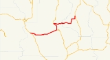
Oregon Route 216 is an Oregon
state highway
running from U.S. Route 26 at Warm Springs Junction to U.S. Route 97 in Grass Valley
. OR 216 is 61.3 miles (98.7 km) long and runs east–west.
. It heads east along the border between the reservation and Mt. Hood National Forest, then continues through Pine Grove
and past Wapinitia
to an intersection with U.S. Route 197 about two miles (3 km) west of Maupin
. At this intersection, OR 216 overlaps U.S. 197 and continues north to Tygh Valley
. The concurrency ends at Tygh Valley, and OR 216 continues east to Grass Valley, ending at an intersection with US 97.
, the Wapinitia Highway was renumbered as part of OR 216.
The Sherars Bridge Highway can be traced to a bridge over the Deschutes River, built in 1860 and rebuilt in 1862. The bridge was purchased by Deschutes County
in 1912, the modern highway built some time thereafter.
Oregon
Oregon is a state in the Pacific Northwest region of the United States. It is located on the Pacific coast, with Washington to the north, California to the south, Nevada on the southeast and Idaho to the east. The Columbia and Snake rivers delineate much of Oregon's northern and eastern...
state highway
State highway
State highway, state road or state route can refer to one of three related concepts, two of them related to a state or provincial government in a country that is divided into states or provinces :#A...
running from U.S. Route 26 at Warm Springs Junction to U.S. Route 97 in Grass Valley
Grass Valley, Oregon
Grass Valley is a city in Sherman County, Oregon, United States. The population was 171 at the 2000 census.-Geography:According to the United States Census Bureau, the city has a total area of , all land.-Demographics:...
. OR 216 is 61.3 miles (98.7 km) long and runs east–west.
Route description
OR 216 begins at an intersection with US 26 at Warm Springs Junction on the Warm Springs Indian ReservationWarm Springs Indian Reservation
The Warm Springs Indian Reservation consists of 1,019.385 sq mi in north central Oregon, in the United States, and is occupied and governed by the Confederated Tribes of Warm Springs.-Tribes:...
. It heads east along the border between the reservation and Mt. Hood National Forest, then continues through Pine Grove
Pine Grove, Oregon
Pine Grove, Oregon may refer to:*Pine Grove, Hood River County, Oregon, a populated place*Pine Grove, Klamath County, Oregon, a populated place*Pine Grove, Umatilla County, Oregon, a locale*Pine Grove, Wasco County, Oregon, a census-designated place...
and past Wapinitia
Wapinitia, Oregon
Wapinitia is an unincorporated community in Wasco County, Oregon, United States. It is near Oregon Route 216 and is approximately south of the county seat of The Dalles, Oregon. The nearest city is Maupin, which is to the east.- External links :...
to an intersection with U.S. Route 197 about two miles (3 km) west of Maupin
Maupin, Oregon
Maupin is a city in Wasco County, Oregon, United States. Located on the Deschutes River, much of the city's economy is related to the river through outdoor activities, such as fishing and rafting...
. At this intersection, OR 216 overlaps U.S. 197 and continues north to Tygh Valley
Tygh Valley, Oregon
* Annual Average High Temperatures: 86 °F 41 °F * Annual Average Low Temperatures 50 °F 26 °F * Highest Recorded Temperature: 110 °F * Lowest Recorded Temperature: -28 °F...
. The concurrency ends at Tygh Valley, and OR 216 continues east to Grass Valley, ending at an intersection with US 97.
Highways comprising
OR 216 comprises the following named highways (see Oregon highways and routes):- The Wapinitia Highway No. 44;
- Part of The Dalles-California Highway No. 4; and
- The Sherars Bridge Highway No. 290.
History
The Wapinitia Highway was originally designated part of OR 50. In 1950, it was redesignated OR 52, as the OR 50 designation was moved to the Warm Springs Highway No. 53, and is now part of US 26. In 1952, when the former OR 90 was renumbered OR 52 to conform to its intersection with ID 52Idaho State Highway 52
State Highway 52 is a state highway in the U.S. State of Idaho that travels along the Payette River from the Oregon State Line and Snake River to Horseshoe Bend.-Route description:...
, the Wapinitia Highway was renumbered as part of OR 216.
The Sherars Bridge Highway can be traced to a bridge over the Deschutes River, built in 1860 and rebuilt in 1862. The bridge was purchased by Deschutes County
Deschutes County, Oregon
-National protected areas:* Deschutes National Forest * Newberry National Volcanic Monument-Demographics:As of the census of 2000, there were 115,367 people, 45,595 households, and 31,962 families residing in the county. The population density was 38 people per square mile . There were 54,583...
in 1912, the modern highway built some time thereafter.
Major intersections
| Highway | Milepost | City | Intersection |
|---|---|---|---|
| Wapinitia | 0.18 | Warm Springs Junction | US 26 |
| Wapinitia / The Dalles-California | 26.03 / 42.43 | Near Maupin Maupin, Oregon Maupin is a city in Wasco County, Oregon, United States. Located on the Deschutes River, much of the city's economy is related to the river through outdoor activities, such as fishing and rafting... |
US 197 (Begin concurrency) |
| The Dalles-California / Sherars Bridge | 33.89 / -0.05 | Tygh Valley Tygh Valley, Oregon * Annual Average High Temperatures: 86 °F 41 °F * Annual Average Low Temperatures 50 °F 26 °F * Highest Recorded Temperature: 110 °F * Lowest Recorded Temperature: -28 °F... |
US 197 (End concurrency) |
| Sherars Bridge | 28.42 | Grass Valley Grass Valley, Oregon Grass Valley is a city in Sherman County, Oregon, United States. The population was 171 at the 2000 census.-Geography:According to the United States Census Bureau, the city has a total area of , all land.-Demographics:... |
US 97 |
Related routes
- U.S. Route 26
- U.S. Route 197
- U.S. Route 97
- U.S. Route 395
- Former OR 50
- OR 52