

Twechar
Encyclopedia
Twechar is a small former mining village
in East Dunbartonshire
, Scotland
. It lies between the larger towns of Kirkintilloch
and Kilsyth
.
The Forth and Clyde Canal
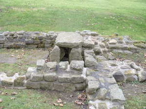
runs close to the village to the north, and closely follows the line of the Antonine Wall
. There are visible remains of the wall on Barhill- and the Roman Fort is a local tourist attraction.
Pits were sunk at Twechar and Gartshore and a row of workers' houses was built on the south bank of the Forth and Clyde canal, just east of Twechar Bridge.
The coal mining industry begun by the Bairds in the 1860s lasted for just over a century. Twechar No.1 Pit, on the north bank of the canal to the east of Twechar Bridge, closed in 1964, while Gartshore 9/11, the very last colliery in the area, was shut down in 1968. Thereafter some Twechar men travelled each day to collieries such as Bedlay and Cardowan
in Lanarkshire
, until they too were closed, during the early 1980s.
Baird & Co. provided rail connections to their local pits at an early date but for many years much of their coal was transported to market by canal boat. During the 1860s the canal company permitted Baird & Co. to place a railway swing bridge
over the canal, a short distance to the west of Twechar road bridge, for the purpose of forming a connection between collieries on either side of the canal. As part of the deal the coal company agreed to transport a proportion of its coal by canal although this requirement lapsed early in the twentieth century. However, the swing bridge continued in use until the mid-1960s, its hand-winding apparatus having been made redundant on 1 January 1963, when the canal closed.
At first there were four rows, supplemented by two more about 1900, by which date the total number of dwellings in the rows was 160. The row nearest the canal included a Gartsherrie Co-operative shop and accordingly was known as the 'Store Row'.
Initially the houses had no sanitation and were lit by paraffin lamps. Communal wash houses were provided at intervals along each row. Most of the houses were of the two-apartment (room & kitchen) variety.
A great improvement was made in 1925, when Baird & Co. (in response to considerable pressure from the miners themselves, over the years) provided good quality modern housing for their mine workers at Burnbrae, Annieston, Sunnyhill and adjacent streets. There were 200 dwellings in all, some two-apartment and some three-apartment, built in two-story blocks of four. They were provided with bathrooms and electric lighting. When these houses were built the old row on the south bank of the canal was demolished. The Barrhill Rows, however, lasted until 1957. The Baird houses of 1925 are currently being demolished and little remains of Burnbrae ,Whitelaw Terrace , Shirva lea and Merryflats ( Nov 09 ). Later housing was provided by Dunbartonshire
County Council
at MacDonald Crescent (1939), Alexander Avenue (1948) and Kelvin View (about 1955).
and Kirkintilloch
opened and secondary age pupils were sent by bus to these schools.
Pupils from Twechar Primary now go on to further education at the new state of the art Kirkintilloch High School http://www.kirkintilloch.e-dunbarton.sch.uk/page_viewer.asp?page=Home&pid=1.
The Roman Catholic children are taught at St Agathas in Kirkintilloch for their primary and the new St Ninians, Kirkintilloch for their secondary education.
 The reopening of the Forth & Clyde Canal, in May 2001, brought with it great opportunities for the development of Twechar, which lies close to the canal's half-way point.
Currently the village is undergoing a regeneration, EDC and private enterprise have put forward proposals to build approximately 200+ new houses, older housing stock in the "National Coal Board
" scheme will be demolished from late 2007 onwards if the plan goes ahead.
Newer small business units have also been built in the small enterprise park opposite the war memorial,and an application for new housing has been raised with the council for new housing next to Kelvin View ( Nov 09 ).
Various new walkways have also been made ,in and around the village and the glen.
The local leisure centre has undergone an expensive renovation and has been re-titled " The Twechar healthy living and enterprise centre." There is also a pharmacy run by M & D Green Dispensing Chemists Ltd. Negotiations to obtain a GP have been ongoing for some time.
An area to the rear of the Masonic Hall ( Lodge Barrhill Twechar 1444 ) has already been developed for boating purposes on the canal , hopefully there will be a community canal boat in place in the near future.
congregation, Twechar Parish Church, which shares a minister with Banton. The Roman Catholic villagers are served by St. John of the Cross Chapel in Twechar. There is also a Church of the Nazarene.
Pit village
A pit village is a term used in the UK for the village serving a deep coal mine.Many of the workers lived in houses that were provided by the colliery. Many villages have experienced depopulation after colliery closures forced people to move to other towns and cities where there are jobs for them...
in East Dunbartonshire
East Dunbartonshire
This article is about the East Dunbartonshire council area of Scotland. See also East Dunbartonshire .East Dunbartonshire is one of the 32 council areas of Scotland. It borders onto the north-west of the City of Glasgow. It contains many of the suburbs of Glasgow as well as containing many of...
, Scotland
Scotland
Scotland is a country that is part of the United Kingdom. Occupying the northern third of the island of Great Britain, it shares a border with England to the south and is bounded by the North Sea to the east, the Atlantic Ocean to the north and west, and the North Channel and Irish Sea to the...
. It lies between the larger towns of Kirkintilloch
Kirkintilloch
Kirkintilloch is a town and former burgh in East Dunbartonshire, Scotland. It lies on the Forth and Clyde Canal, about eight miles northeast of central Glasgow...
and Kilsyth
Kilsyth
Kilsyth is a town of 10,100 roughly halfway between Glasgow and Stirling in North Lanarkshire, Scotland.-Location:...
.
The Forth and Clyde Canal
Forth and Clyde Canal
The Forth and Clyde Canal crosses Scotland, providing a route for sea-going vessels between the Firth of Forth and the Firth of Clyde at the narrowest part of the Scottish Lowlands. The canal is 35 miles long and its eastern end is connected to the River Forth by a short stretch of the River...
runs close to the village to the north, and closely follows the line of the Antonine Wall
Antonine Wall
The Antonine Wall is a stone and turf fortification built by the Romans across what is now the Central Belt of Scotland, between the Firth of Forth and the Firth of Clyde. Representing the northernmost frontier barrier of the Roman Empire, it spanned approximately 39 miles and was about ten feet ...
. There are visible remains of the wall on Barhill- and the Roman Fort is a local tourist attraction.
Mining
There is a long history of mining activity in the Twechar locality but it was not until the coming of William Baird & Co. to the area, about 1860, that a close-knit mining community was created.Pits were sunk at Twechar and Gartshore and a row of workers' houses was built on the south bank of the Forth and Clyde canal, just east of Twechar Bridge.
The coal mining industry begun by the Bairds in the 1860s lasted for just over a century. Twechar No.1 Pit, on the north bank of the canal to the east of Twechar Bridge, closed in 1964, while Gartshore 9/11, the very last colliery in the area, was shut down in 1968. Thereafter some Twechar men travelled each day to collieries such as Bedlay and Cardowan
Cardowan
Cardowan, is a small town in North Lanarkshire, Scotland, now a suburb of Glasgow, situated to the south of Stepps, on the north-eastern outskirts of Glasgow which grew around Cardowan Colliery, Garnkirk Fire-clay works, and clay mines in the immediate area....
in Lanarkshire
Lanarkshire
Lanarkshire or the County of Lanark ) is a Lieutenancy area, registration county and former local government county in the central Lowlands of Scotland...
, until they too were closed, during the early 1980s.
Baird & Co. provided rail connections to their local pits at an early date but for many years much of their coal was transported to market by canal boat. During the 1860s the canal company permitted Baird & Co. to place a railway swing bridge
Swing bridge
A swing bridge is a movable bridge that has as its primary structural support a vertical locating pin and support ring, usually at or near to its centre of gravity, about which the turning span can then pivot horizontally as shown in the animated illustration to the right...
over the canal, a short distance to the west of Twechar road bridge, for the purpose of forming a connection between collieries on either side of the canal. As part of the deal the coal company agreed to transport a proportion of its coal by canal although this requirement lapsed early in the twentieth century. However, the swing bridge continued in use until the mid-1960s, its hand-winding apparatus having been made redundant on 1 January 1963, when the canal closed.
Housing
The original housing provided by William Baird & Co soon proved inadequate and around 1880 the Barrhill Rows were constructed at right angles to Main Street, on its western side.At first there were four rows, supplemented by two more about 1900, by which date the total number of dwellings in the rows was 160. The row nearest the canal included a Gartsherrie Co-operative shop and accordingly was known as the 'Store Row'.
Initially the houses had no sanitation and were lit by paraffin lamps. Communal wash houses were provided at intervals along each row. Most of the houses were of the two-apartment (room & kitchen) variety.
A great improvement was made in 1925, when Baird & Co. (in response to considerable pressure from the miners themselves, over the years) provided good quality modern housing for their mine workers at Burnbrae, Annieston, Sunnyhill and adjacent streets. There were 200 dwellings in all, some two-apartment and some three-apartment, built in two-story blocks of four. They were provided with bathrooms and electric lighting. When these houses were built the old row on the south bank of the canal was demolished. The Barrhill Rows, however, lasted until 1957. The Baird houses of 1925 are currently being demolished and little remains of Burnbrae ,Whitelaw Terrace , Shirva lea and Merryflats ( Nov 09 ). Later housing was provided by Dunbartonshire
Dunbartonshire
Dunbartonshire or the County of Dumbarton is a lieutenancy area and registration county in the west central Lowlands of Scotland lying to the north of the River Clyde. Until 1975 it was a county used as a primary unit of local government with its county town and administrative centre at the town...
County Council
County council
A county council is the elected administrative body governing an area known as a county. This term has slightly different meanings in different countries.-United Kingdom:...
at MacDonald Crescent (1939), Alexander Avenue (1948) and Kelvin View (about 1955).
Schools
The village also had its own secondary education in Twechar School (now Twechar Primary School) until secondary schools in CumbernauldCumbernauld
Cumbernauld is a Scottish new town in North Lanarkshire. It was created in 1956 as a population overspill for Glasgow City. It is the eighth most populous settlement in Scotland and the largest in North Lanarkshire...
and Kirkintilloch
Kirkintilloch
Kirkintilloch is a town and former burgh in East Dunbartonshire, Scotland. It lies on the Forth and Clyde Canal, about eight miles northeast of central Glasgow...
opened and secondary age pupils were sent by bus to these schools.
Pupils from Twechar Primary now go on to further education at the new state of the art Kirkintilloch High School http://www.kirkintilloch.e-dunbarton.sch.uk/page_viewer.asp?page=Home&pid=1.
The Roman Catholic children are taught at St Agathas in Kirkintilloch for their primary and the new St Ninians, Kirkintilloch for their secondary education.
Redevelopment
Currently the village is undergoing a regeneration, EDC and private enterprise have put forward proposals to build approximately 200+ new houses, older housing stock in the "National Coal Board
National Coal Board
The National Coal Board was the statutory corporation created to run the nationalised coal mining industry in the United Kingdom. Set up under the Coal Industry Nationalisation Act 1946, it took over the mines on "vesting day", 1 January 1947...
" scheme will be demolished from late 2007 onwards if the plan goes ahead.
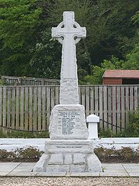
Newer small business units have also been built in the small enterprise park opposite the war memorial,and an application for new housing has been raised with the council for new housing next to Kelvin View ( Nov 09 ).
Various new walkways have also been made ,in and around the village and the glen.
The local leisure centre has undergone an expensive renovation and has been re-titled " The Twechar healthy living and enterprise centre." There is also a pharmacy run by M & D Green Dispensing Chemists Ltd. Negotiations to obtain a GP have been ongoing for some time.
An area to the rear of the Masonic Hall ( Lodge Barrhill Twechar 1444 ) has already been developed for boating purposes on the canal , hopefully there will be a community canal boat in place in the near future.
Church
There is a Church of ScotlandChurch of Scotland
The Church of Scotland, known informally by its Scots language name, the Kirk, is a Presbyterian church, decisively shaped by the Scottish Reformation....
congregation, Twechar Parish Church, which shares a minister with Banton. The Roman Catholic villagers are served by St. John of the Cross Chapel in Twechar. There is also a Church of the Nazarene.