
Blaine, Washington
Encyclopedia
Blaine is a city in Whatcom County, Washington
, United States. The city's northern boundary is the Canadian border. Blaine is the shared home of the Peace Arch
international monument. The population was 4,684 at the 2010 census.
's gold fields. Blaine was officially incorporated on May 20, 1890, and was named after James G. Blaine
(1830–1893), who was a U.S. senator
from the state of Maine
, Secretary of State
, and, in 1884
, the unsuccessful Republican
presidential candidate. The city has a "turn-of-the-century" theme, marked by remodeled buildings and signs resembling designs that existed during the late 19th century and early 20th century.
The world's largest salmon
cannery was operated by the Alaska Packer's Association for decades in Blaine; the cannery site has been converted to a waterfront destination resort on Semiahmoo Spit
. Several saw mills once operated on Blaine's waterfront, and much of the lumber was transported from its wharves and docks to help rebuild San Francisco following the 1906 fire
there. The forests were soon logged, but Blaine's fishing industry remained strong and robust into the second half of the 20th century. Into the 1970s Blaine was home to hundreds of commercial purse seiners and gillnet
ters plying the waters offshore of British Columbia, between Washington State and southeast Alaska. Blaine's two large marinas are still home to hundreds of recreational sailboats and yachts, and a small fleet of determined local fishers provide visitors with dockside sale of fresh salmon, crab and oysters. Nature lovers have always appreciated Blaine's coastal location, its accessible bike and walking trails, and view of mountains and water. Birdwatchers across the continent have discovered the area's high content of migratory birds
and waterfowl: Blaine's Drayton Harbor, Semiahmoo Spit and Boundary Bay are ranked as Important Birding Areas by the Audubon Society.
 The Cains are the most notable family in Blaine's short history, credited with its founding and achievements. At one time owning most of present day Blaine, the Cain brothers erected the biggest store north of Seattle, a lumber and shingle mill, a hotel (largest in the state at the time), the first public wharf, and donated large public tracts of land.
Nathan Cornish and family moved to Blaine in 1889. He became mayor in 1901; his platform was "twelve miles of wooden sidewalk." His daughter, Nellie Cornish
, having failed to open a successful piano teaching business in Blaine, moved to Seattle, where she founded the Cornish College of the Arts
in 1914, which still exists today.
During the formative years of her career in the 1950s, Country singer Loretta Lynn
was often a featured star at Bill's Tavern on Peace Portal Drive in Blaine. William Hafstrom owned the tavern; it no longer exists. Lynn was then living on Loomis Trail Road near Custer, Washington.
, the flatlands of Skagit County, Washington
, the North Cascades
(including Mount Baker
), and the south end of Vancouver Island
. The coastal climate of the area provides fairly mild weather from the rest of the Pacific Northwest
. With annual precipitation of about 1000 mm (40 inches) and its milder location, Blaine enjoys more sunny days and a milder climate than neighboring communities.
between the United States and Canada. The Peace Arch Crossing, which is the northern terminus of I-5
and southern terminus of B.C. provincial Highway 99, serves as the primary passenger vehicle port of entry. The Pacific Border Crossing, approximately one mile to the east, serves as the primary point of entry for heavy truck traffic, and thus is also known as the Truck Crossing. The latter is reached via Washington State Route 543 which departs I-5 on the south side of Blaine and connects at the border to B.C.'s Highway 15 (Surrey's 176th Street
) and then to the Trans-Canada Highway
.
Construction of a new Land Port of Entry (LPOE) was completed by the U.S. General Services Administration in 2011. A large public art installation entitled "Non-Sign II" was erected near the crossing booths. The art piece is a 'blank space' in the shape of a billboard
sign, surrounded by a mass of twisted metal rods. On the Canadian side, a new Port of Entry building was constructed by the Canada Border Services Agency. It was officially opened by Public Safety Minister Peter Van Loan on August 20, 2009. It was built partly to reduce delays for travellers coming to the 2010 Winter Olympics
which were held in Vancouver
and Whistler
February 12–28, 2010.
International border intrigue has always been a part of Blaine's ambiance. Smuggling became an underground industry in 1919 with the passage of the Volstead Act
banning liquor sale and use in the United States. Rum-running
and border jumping thrived along Blaine's shared coastline with British Columbia
, due in part to the area's largest whiskey still being located on Texada Island
, which is located in the northern Strait of Georgia
offshore from the city of Powell River, British Columbia
. This continued until Prohibition was repealed in 1933 (coincidentally, the US Congressional law which re-legalized alcohol is named the Blaine Act
). In subsequent decades, the situation was reversed due to restrictive drinking and entertainment laws in British Columbia, notably a ban on Sunday drinking, which led to Blaine and its sister border towns of Point Roberts and Sumas booming with taverns and adult entertainment of various kinds. Those days are long gone and now Blaine's retail sector booms for goods such as gasoline, dairy products and clothing outlets, as these goods are cheaper in the U.S., as well as the Canadian dollar surpassing the U.S. dollar in recent years.
 In the 1990s, smuggling again reached a zenith with exports of high grade marijuana from neighboring British Columbia, and corresponding flow of cocaine
and handguns from the United States into Canada. As the production of 'BC Bud
' grew across BC, a sometimes dangerous game of cat and mouse played out along Blaine's border with Canada. Smugglers used every technique, from backpacks to helicopter aerial drops to bring tons of the marijuana crop into the US, while a growing phalanx of local, state, provincial and federal law enforcement from both sides of the border sought ways to stem the tide. Following the terrorist attacks of 2001, the addition of hundreds of federal agents and millions of dollars in enforcement technology have pushed much of the smuggling activity into the rugged interior of Washington.
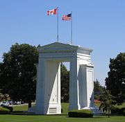
With its location at the intersection of an international border, a major interstate freeway, and the Pacific Ocean, Blaine is frequently in the news. The International Peace Arch, dedicated September 6, 1921 by founder Samuel Hill
, is located in Blaine in Peace Arch State Park and is occasionally used as a focal point for peaceful demonstrations and debate, such as the annual setting of crosses for each American killed so far in the Iraq War. But most of the people who visit or pass by the Park each year remember it for its beauty and peaceful shoreline setting (although the beach is not officially accessible from the park).
The Interstate 5
freeway extends from the U.S./ Mexico border at San Diego, northward to Canada, and terminates in Blaine at the city's northern border
. The country's only pedestrian crosswalk to cross an Interstate freeway exists in Peace Arch State Park. Peace Arch State Park has a sister park on the Canadian side, Peace Arch Provincial Park, the location of which is Douglas
, the Canadian port-of-entry and which is part of the Canadian city of Surrey, British Columbia
. The Peace Arch monument
, located in the Park, symbolizes lasting peace and amity between the U.S. and Canada. One innovative feature that has never been abrogated even during the days since 9/11, is that people entering the Park from either side may have the unique experience of strolling to the opposite park's boundary amid flowers, ponds, and works of art, without having to go through Immigration, thus truly making the Park a place of bi-national mingling. Frequently, weddings ceremonies are performed in the Park.
In 2006, a local group called the Blaine Peace Alliance unsuccessfully solicited City Council support to formalize a sister-city relationship with Pugwash, Nova Scotia
, where promotion of world peace had been an ongoing effort for 50 years. Because Pugwash affiliated itself with the Pugwash Conferences on Science and World Affairs
, the Council ruled such a connection would be "political". Shortly thereafter, the Alliance disbanded.
Since 1937, an annual celebration known as "Hands Across the Border" has been held at the Park, sponsored by the International Peace Arch Association. Hundreds of Scouts from the U.S. and Canada are in attendance and the highways and Ports of Entry on both sides of the border are closed for several hours for the event. There is a procession of Troops and world flags through the Peace Arch, signifying Scout unity around the world. Speeches are made by honored Scouts from Washington and British Columbia, and State, Provincial and local dignitaries attend.
, the city has a total area of 8.5 square miles (22.0 km²), of which, 5.5 square miles (14.3 km²) of it is land and 3.0 square miles (7.6 km²) of it (34.57%) is water.
Blaine's motto is "Where America Begins": the community is also known as "The Gateway to the Pacific Northwest", and the "Peace Arch City". All these phrases are commentaries on Blaine's unique locale. It lies at the northernmost point of the north-south U.S. Interstate 5
and next to Drayton Harbor and Boundary Bay
(the southward extension of Boundary Bay is officially named and often referred to as Semiahmoo Bay
).
Blaine had a small airport, which was popular with light aircraft
owners for its low fuel prices and because it had less fog than other nearby airports. The runway measured 2539 × 40 feet (774 × 12 m). The Blaine city government operated automated fuel pumps. In the spring of 2006 the city government removed several tall trees south of the runway as a safety precaution. Then in 2007, the City Council voted to close the airport before the end of 2008. The airport was officially closed on December 31, 2008. The land upon which the airport rests is adjacent to a shopping center and light industrial park. The area is now zoned for mixed use development, including light industrial manufacturing and commercial.
As of the 2000 census, there were 3,770 people, 1,496 households, and 1,036 families residing in the city. The population density was 680.4 people per square mile (262.7/km²). There were 1,737 housing units at an average density of 313.5 per square mile (121.1/km²). The racial makeup of the city was 87.72% White, 1.19% African American, 1.14% Native American, 4.19% Asian, 0.66% Pacific Islander, 1.33% from other races
, and 3.77% from two or more races. Hispanic or Latino of any race were 4.35% of the population.
There were 1,496 households out of which 32.1% had children under the age of 18 living with them, 52.9% were married couples living together, 12.4% had a female householder with no husband present, and 30.7% were non-families. 25.5% of all households were made up of individuals and 10.1% had someone living alone who was 65 years of age or older. The average household size was 2.48 and the average family size was 2.96.
In the city the age distribution of the population shows 26.5% under the age of 18, 6.9% from 18 to 24, 26.4% from 25 to 44, 25.7% from 45 to 64, and 14.4% who were 65 years of age or older. The median age was 39 years. For every 100 females there were 94.5 males. For every 100 females age 18 and over, there were 90.2 males.
The median income for a household in the city was $36,900, and the median income for a family was $45,056. Males had a median income of $36,381 versus $23,561 for females. The per capita income
for the city was $20,333. About 10.2% of families and 15.5% of the population were below the poverty line, including 16.6% of those under age 18 and 8.3% of those age 65 or over.
Blaine also has a number of manufacturing companies, including Nature's Path Cereal and Totally Chocolate.
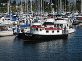
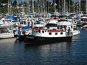
The Port of Bellingham
operates a large marina
in Blaine, serving a variety of pleasure craft and fishing vessels.
#503 serves a population which extends to the south end of nearby Birch Bay, well beyond the city limits of Blaine. The largest share of school services is consolidated on a large (quarter mile square) campus in central Blaine. Approximately 2,500 students of all grades (K-12) attend school in facilities which separately house K-2, 3-5, 6-8, and 9-12th grades respectively. Students from the small nearby US exclave of Point Roberts, Washington
above 3rd grade are bused through the border to Blaine to attend school.
Whatcom County, Washington
Whatcom County is a county located in the U.S. state of Washington. Its name ultimately derives from the Lummi word Xwotʼqom, meaning "noisy water." As of 2010, the population was 201,140. The county seat is at Bellingham, which is also the county's largest city...
, United States. The city's northern boundary is the Canadian border. Blaine is the shared home of the Peace Arch
Peace Arch
The Peace Arch is a monument situated on the Canada – United States border between the communities of Blaine, Washington and Surrey, British Columbia. The Peace Arch, which stands...
international monument. The population was 4,684 at the 2010 census.
History
The area was first settled in the mid-19th century by pioneers who established the town as a seaport for the west coast logging and fishing industries, and as a jumping off point for prospectors heading to British ColumbiaBritish Columbia
British Columbia is the westernmost of Canada's provinces and is known for its natural beauty, as reflected in its Latin motto, Splendor sine occasu . Its name was chosen by Queen Victoria in 1858...
's gold fields. Blaine was officially incorporated on May 20, 1890, and was named after James G. Blaine
James G. Blaine
James Gillespie Blaine was a U.S. Representative, Speaker of the United States House of Representatives, U.S. Senator from Maine, two-time Secretary of State...
(1830–1893), who was a U.S. senator
United States Senate
The United States Senate is the upper house of the bicameral legislature of the United States, and together with the United States House of Representatives comprises the United States Congress. The composition and powers of the Senate are established in Article One of the U.S. Constitution. Each...
from the state of Maine
Maine
Maine is a state in the New England region of the northeastern United States, bordered by the Atlantic Ocean to the east and south, New Hampshire to the west, and the Canadian provinces of Quebec to the northwest and New Brunswick to the northeast. Maine is both the northernmost and easternmost...
, Secretary of State
United States Secretary of State
The United States Secretary of State is the head of the United States Department of State, concerned with foreign affairs. The Secretary is a member of the Cabinet and the highest-ranking cabinet secretary both in line of succession and order of precedence...
, and, in 1884
United States presidential election, 1884
The United States presidential election of 1884 saw the first election of a Democrat as President of the United States since the election of 1856. New York Governor Grover Cleveland narrowly defeated Republican former United States Senator James G. Blaine of Maine to break the longest losing streak...
, the unsuccessful Republican
Republican Party (United States)
The Republican Party is one of the two major contemporary political parties in the United States, along with the Democratic Party. Founded by anti-slavery expansion activists in 1854, it is often called the GOP . The party's platform generally reflects American conservatism in the U.S...
presidential candidate. The city has a "turn-of-the-century" theme, marked by remodeled buildings and signs resembling designs that existed during the late 19th century and early 20th century.
The world's largest salmon
Salmon
Salmon is the common name for several species of fish in the family Salmonidae. Several other fish in the same family are called trout; the difference is often said to be that salmon migrate and trout are resident, but this distinction does not strictly hold true...
cannery was operated by the Alaska Packer's Association for decades in Blaine; the cannery site has been converted to a waterfront destination resort on Semiahmoo Spit
Semiahmoo Spit
Semiahmoo Spit is a spit that protrudes from the westernmost expanse of shore along Drayton Harbor in the city of Blaine, WA located in Whatcom County, WA.-Geomorphology and geography:...
. Several saw mills once operated on Blaine's waterfront, and much of the lumber was transported from its wharves and docks to help rebuild San Francisco following the 1906 fire
1906 San Francisco earthquake
The San Francisco earthquake of 1906 was a major earthquake that struck San Francisco, California, and the coast of Northern California at 5:12 a.m. on Wednesday, April 18, 1906. The most widely accepted estimate for the magnitude of the earthquake is a moment magnitude of 7.9; however, other...
there. The forests were soon logged, but Blaine's fishing industry remained strong and robust into the second half of the 20th century. Into the 1970s Blaine was home to hundreds of commercial purse seiners and gillnet
Gillnet
Gillnetting is a common fishing method used by commercial and artisanal fishermen of all the oceans and in some freshwater and estuary areas. The gillnet also is used by fisheries scientists to monitor fish populations. Because gillnets can be so effective their use is closely monitored and...
ters plying the waters offshore of British Columbia, between Washington State and southeast Alaska. Blaine's two large marinas are still home to hundreds of recreational sailboats and yachts, and a small fleet of determined local fishers provide visitors with dockside sale of fresh salmon, crab and oysters. Nature lovers have always appreciated Blaine's coastal location, its accessible bike and walking trails, and view of mountains and water. Birdwatchers across the continent have discovered the area's high content of migratory birds
Bird migration
Bird migration is the regular seasonal journey undertaken by many species of birds. Bird movements include those made in response to changes in food availability, habitat or weather. Sometimes, journeys are not termed "true migration" because they are irregular or in only one direction...
and waterfowl: Blaine's Drayton Harbor, Semiahmoo Spit and Boundary Bay are ranked as Important Birding Areas by the Audubon Society.
Nathan Cornish and family moved to Blaine in 1889. He became mayor in 1901; his platform was "twelve miles of wooden sidewalk." His daughter, Nellie Cornish
Nellie Cornish
Nellie Centennial Cornish was a pianist, teacher, writer, and founder of the Cornish School in Seattle, Washington. She was influenced by the pedagogical ideas of Maria Montessori as well as Calvin Brainerd Cady's ideas about teaching broader values through music education...
, having failed to open a successful piano teaching business in Blaine, moved to Seattle, where she founded the Cornish College of the Arts
Cornish College of the Arts
-Library:The library at Cornish College specializes in art, dance, design, music, performance production, and theatre. As of 2011 it holds 4700 CDs, 40,000 books, has 2,200 videos, and subscribes to 154 periodicals...
in 1914, which still exists today.
During the formative years of her career in the 1950s, Country singer Loretta Lynn
Loretta Lynn
Loretta Lynn is an American country music singer-songwriter, author and philanthropist. Born in Butcher Hollow, Kentucky to a coal miner father, Lynn married at 13 years old, was a mother soon after, and moved to Washington with her husband, Oliver Lynn. Their marriage was sometimes tumultuous; he...
was often a featured star at Bill's Tavern on Peace Portal Drive in Blaine. William Hafstrom owned the tavern; it no longer exists. Lynn was then living on Loomis Trail Road near Custer, Washington.
Climate
Blaine lies between the mountains east of VancouverVancouver
Vancouver is a coastal seaport city on the mainland of British Columbia, Canada. It is the hub of Greater Vancouver, which, with over 2.3 million residents, is the third most populous metropolitan area in the country,...
, the flatlands of Skagit County, Washington
Skagit County, Washington
Skagit County is a county in the U.S. state of Washington. It is named after the Skagit Indian tribe. As of 2010, the population was 116,901. It is included in the Mount Vernon-Anacortes, Washington, Metropolitan Statistical Area...
, the North Cascades
North Cascades
The North Cascades are a section of the Cascade Range of western North America. They span the border between the Canadian province of British Columbia and the U.S. state of Washington and are officially named in Canada as the Cascade Mountains...
(including Mount Baker
Mount Baker
Mount Baker , also known as Koma Kulshan or simply Kulshan, is an active glaciated andesitic stratovolcano in the Cascade Volcanic Arc and the North Cascades of Washington State in the United States. It is the second-most active volcano in the range after Mount Saint Helens...
), and the south end of Vancouver Island
Vancouver Island
Vancouver Island is a large island in British Columbia, Canada. It is one of several North American locations named after George Vancouver, the British Royal Navy officer who explored the Pacific Northwest coast of North America between 1791 and 1794...
. The coastal climate of the area provides fairly mild weather from the rest of the Pacific Northwest
Pacific Northwest
The Pacific Northwest is a region in northwestern North America, bounded by the Pacific Ocean to the west and, loosely, by the Rocky Mountains on the east. Definitions of the region vary and there is no commonly agreed upon boundary, even among Pacific Northwesterners. A common concept of the...
. With annual precipitation of about 1000 mm (40 inches) and its milder location, Blaine enjoys more sunny days and a milder climate than neighboring communities.
| Month | Jan | Feb | Mar | Apr | May | Jun | Jul | Aug | Sep | Oct | Nov | Dec | Year |
|---|---|---|---|---|---|---|---|---|---|---|---|---|---|
| Avg high °F (°C) |
43 (6) |
48 (9) |
52 (11) |
58 (14) |
64 (18) |
69 (21) |
72 (22) |
72 (22) |
67 (19) |
58 (14) |
49 (9) |
43 (6) |
58 (14) |
| Avg low °F (°C) |
30 (-1) |
32 (0) |
34 (1) |
38 (3) |
43 (6) |
48 (9) |
51 (11) |
51 (11) |
46 (8) |
40 (4) |
35 (2) |
31 (-1) |
40 (4) |
| Precipitation in inches (millimeters) |
5.32 (135.1) |
4.21 (106.9) |
3.61 (91.7) |
2.85 (72.4) |
2.58 (65.5) |
2.14 (54.4) |
1.49 (37.8) |
1.51 (38.4) |
1.91 (48.5) |
3.74 (95.0) |
6.29 (159.8) |
5.79 (147.1) |
41.44 (1052.6) |
| Source: http://www.weather.com/outlook/recreation/outdoors/wxclimatology/monthly/graph/USWA0036?lswe=Blaine,%20WA&lwsa=Weather36HourOutdoorsCommand&from=whatmenu_dropdown_driving | |||||||||||||
Canadian Border
Blaine is home to two main West Coast ports of entryPort of entry
In general, a port of entry is a place where one may lawfully enter a country. It typically has a staff of people who check passports and visas and inspect luggage to assure that contraband is not imported. International airports are usually ports of entry, as are road and rail crossings on a...
between the United States and Canada. The Peace Arch Crossing, which is the northern terminus of I-5
Interstate 5
Interstate 5 is the main Interstate Highway on the West Coast of the United States, running largely parallel to the Pacific Ocean coastline from Canada to Mexico . It serves some of the largest cities on the U.S...
and southern terminus of B.C. provincial Highway 99, serves as the primary passenger vehicle port of entry. The Pacific Border Crossing, approximately one mile to the east, serves as the primary point of entry for heavy truck traffic, and thus is also known as the Truck Crossing. The latter is reached via Washington State Route 543 which departs I-5 on the south side of Blaine and connects at the border to B.C.'s Highway 15 (Surrey's 176th Street
British Columbia Highway 15
Highway 15 , known locally as the Pacific Highway, is a long north–south highway primarily located in the City of Surrey, British Columbia. The southern terminus is with Interstate 5 near Blaine, Washington as Washington State Route 543...
) and then to the Trans-Canada Highway
Trans-Canada Highway
The Trans-Canada Highway is a federal-provincial highway system that joins the ten provinces of Canada. It is, along with the Trans-Siberian Highway and Australia's Highway 1, one of the world's longest national highways, with the main route spanning 8,030 km...
.
Construction of a new Land Port of Entry (LPOE) was completed by the U.S. General Services Administration in 2011. A large public art installation entitled "Non-Sign II" was erected near the crossing booths. The art piece is a 'blank space' in the shape of a billboard
Billboard
Billboard is a weekly American magazine devoted to the music industry, and is one of the oldest trade magazines in the world. It maintains several internationally recognized music charts that track the most popular songs and albums in various categories on a weekly basis...
sign, surrounded by a mass of twisted metal rods. On the Canadian side, a new Port of Entry building was constructed by the Canada Border Services Agency. It was officially opened by Public Safety Minister Peter Van Loan on August 20, 2009. It was built partly to reduce delays for travellers coming to the 2010 Winter Olympics
2010 Winter Olympics
The 2010 Winter Olympics, officially the XXI Olympic Winter Games or the 21st Winter Olympics, were a major international multi-sport event held from February 12–28, 2010, in Vancouver, British Columbia, Canada, with some events held in the suburbs of Richmond, West Vancouver and the University...
which were held in Vancouver
Vancouver
Vancouver is a coastal seaport city on the mainland of British Columbia, Canada. It is the hub of Greater Vancouver, which, with over 2.3 million residents, is the third most populous metropolitan area in the country,...
and Whistler
Whistler, British Columbia
Whistler is a Canadian resort town in the southern Pacific Ranges of the Coast Mountains in the province of British Columbia, Canada, approximately north of Vancouver...
February 12–28, 2010.
International border intrigue has always been a part of Blaine's ambiance. Smuggling became an underground industry in 1919 with the passage of the Volstead Act
Volstead Act
The National Prohibition Act, known informally as the Volstead Act, was the enabling legislation for the Eighteenth Amendment which established prohibition in the United States...
banning liquor sale and use in the United States. Rum-running
Rum-running
Rum-running, also known as bootlegging, is the illegal business of transporting alcoholic beverages where such transportation is forbidden by law...
and border jumping thrived along Blaine's shared coastline with British Columbia
British Columbia
British Columbia is the westernmost of Canada's provinces and is known for its natural beauty, as reflected in its Latin motto, Splendor sine occasu . Its name was chosen by Queen Victoria in 1858...
, due in part to the area's largest whiskey still being located on Texada Island
Texada Island
Texada Island is the largest island in the Strait of Georgia of British Columbia, Canada. Its northern tip is located about southwest of the city of Powell River and west of the Sechelt Peninsula on the Sunshine Coast. A former mining and logging area, the island still has a few quarries and old...
, which is located in the northern Strait of Georgia
Strait of Georgia
The Strait of Georgia or the Georgia Strait is a strait between Vancouver Island and the mainland coast of British Columbia, Canada. It is approximately long and varies in width from...
offshore from the city of Powell River, British Columbia
Powell River, British Columbia
Powell River is a city on the northern Sunshine Coast of southwestern British Columbia, Canada. Most of its population lives near the eastern shores of Malaspina Strait, that part of the larger Georgia Strait between Texada Island and the Mainland...
. This continued until Prohibition was repealed in 1933 (coincidentally, the US Congressional law which re-legalized alcohol is named the Blaine Act
Blaine Act
The Blaine Act was sponsored by Wisconsin Senator John J. Blaine and passed by the United States Senate on February 17, 1933. It initiated the repeal of the Eighteenth Amendment to the United States Constitution, which established Prohibition in the United States. The repeal was formally adopted as...
). In subsequent decades, the situation was reversed due to restrictive drinking and entertainment laws in British Columbia, notably a ban on Sunday drinking, which led to Blaine and its sister border towns of Point Roberts and Sumas booming with taverns and adult entertainment of various kinds. Those days are long gone and now Blaine's retail sector booms for goods such as gasoline, dairy products and clothing outlets, as these goods are cheaper in the U.S., as well as the Canadian dollar surpassing the U.S. dollar in recent years.
Cocaine
Cocaine is a crystalline tropane alkaloid that is obtained from the leaves of the coca plant. The name comes from "coca" in addition to the alkaloid suffix -ine, forming cocaine. It is a stimulant of the central nervous system, an appetite suppressant, and a topical anesthetic...
and handguns from the United States into Canada. As the production of 'BC Bud
BC Bud
BC Bud is a generic term for several varieties of potent cannabis grown in the Canadian provinceof British Columbia. The term has almost become a brand name, especially in California, Oregon, Alaska, Idaho and Washington, to where most of the province's cannabis is exported...
' grew across BC, a sometimes dangerous game of cat and mouse played out along Blaine's border with Canada. Smugglers used every technique, from backpacks to helicopter aerial drops to bring tons of the marijuana crop into the US, while a growing phalanx of local, state, provincial and federal law enforcement from both sides of the border sought ways to stem the tide. Following the terrorist attacks of 2001, the addition of hundreds of federal agents and millions of dollars in enforcement technology have pushed much of the smuggling activity into the rugged interior of Washington.
With its location at the intersection of an international border, a major interstate freeway, and the Pacific Ocean, Blaine is frequently in the news. The International Peace Arch, dedicated September 6, 1921 by founder Samuel Hill
Samuel Hill
Samuel Hill , usually known as Sam Hill, was a businessman, lawyer, railroad executive and advocate of good roads in the Pacific Northwest...
, is located in Blaine in Peace Arch State Park and is occasionally used as a focal point for peaceful demonstrations and debate, such as the annual setting of crosses for each American killed so far in the Iraq War. But most of the people who visit or pass by the Park each year remember it for its beauty and peaceful shoreline setting (although the beach is not officially accessible from the park).
The Interstate 5
Interstate 5 in Washington
Interstate 5 in Washington is a highway in the U.S. state of Washington that extends from its border with Oregon to its border with Canada...
freeway extends from the U.S./ Mexico border at San Diego, northward to Canada, and terminates in Blaine at the city's northern border
British Columbia
British Columbia is the westernmost of Canada's provinces and is known for its natural beauty, as reflected in its Latin motto, Splendor sine occasu . Its name was chosen by Queen Victoria in 1858...
. The country's only pedestrian crosswalk to cross an Interstate freeway exists in Peace Arch State Park. Peace Arch State Park has a sister park on the Canadian side, Peace Arch Provincial Park, the location of which is Douglas
Douglas, British Columbia
Douglas is a locality in Surrey, British Columbia, Canada, just southeast and outside of the boundary of White Rock, that is the Canadian side of the Peace Arch Border Crossing between British Columbia and Whatcom County, Washington in the United States...
, the Canadian port-of-entry and which is part of the Canadian city of Surrey, British Columbia
Surrey, British Columbia
Surrey is a city in the province of British Columbia, Canada. It is a member municipality of Metro Vancouver, the governing body of the Greater Vancouver Regional District...
. The Peace Arch monument
Peace Arch
The Peace Arch is a monument situated on the Canada – United States border between the communities of Blaine, Washington and Surrey, British Columbia. The Peace Arch, which stands...
, located in the Park, symbolizes lasting peace and amity between the U.S. and Canada. One innovative feature that has never been abrogated even during the days since 9/11, is that people entering the Park from either side may have the unique experience of strolling to the opposite park's boundary amid flowers, ponds, and works of art, without having to go through Immigration, thus truly making the Park a place of bi-national mingling. Frequently, weddings ceremonies are performed in the Park.
In 2006, a local group called the Blaine Peace Alliance unsuccessfully solicited City Council support to formalize a sister-city relationship with Pugwash, Nova Scotia
Pugwash, Nova Scotia
-Notable residents:Notable current and former residents of Pugwash include:*Charles Aubrey Eaton , clergyman and politician who served in the United States House of Representatives, representing the from 1925–1933, and the from 1933-1953....
, where promotion of world peace had been an ongoing effort for 50 years. Because Pugwash affiliated itself with the Pugwash Conferences on Science and World Affairs
Pugwash Conferences on Science and World Affairs
The Pugwash Conferences on Science and World Affairs is an international organization that brings together scholars and public figures to work toward reducing the danger of armed conflict and to seek solutions to global security threats...
, the Council ruled such a connection would be "political". Shortly thereafter, the Alliance disbanded.
Since 1937, an annual celebration known as "Hands Across the Border" has been held at the Park, sponsored by the International Peace Arch Association. Hundreds of Scouts from the U.S. and Canada are in attendance and the highways and Ports of Entry on both sides of the border are closed for several hours for the event. There is a procession of Troops and world flags through the Peace Arch, signifying Scout unity around the world. Speeches are made by honored Scouts from Washington and British Columbia, and State, Provincial and local dignitaries attend.
Geography
According to the United States Census BureauUnited States Census Bureau
The United States Census Bureau is the government agency that is responsible for the United States Census. It also gathers other national demographic and economic data...
, the city has a total area of 8.5 square miles (22.0 km²), of which, 5.5 square miles (14.3 km²) of it is land and 3.0 square miles (7.6 km²) of it (34.57%) is water.
Blaine's motto is "Where America Begins": the community is also known as "The Gateway to the Pacific Northwest", and the "Peace Arch City". All these phrases are commentaries on Blaine's unique locale. It lies at the northernmost point of the north-south U.S. Interstate 5
Interstate 5 in Washington
Interstate 5 in Washington is a highway in the U.S. state of Washington that extends from its border with Oregon to its border with Canada...
and next to Drayton Harbor and Boundary Bay
Boundary Bay
Boundary Bay is situated on the Pacific coast of North America on the border between the Canadian province of British Columbia and the U.S. state of Washington....
(the southward extension of Boundary Bay is officially named and often referred to as Semiahmoo Bay
Semiahmoo Bay
Semiahmoo Bay is the southeastern section of Boundary Bay on the Pacific coast of North America. The name "Semiahmoo" is a Coast Salish word for "half moon".From the north to south, the following communities and places are located on its shore:...
).
Blaine had a small airport, which was popular with light aircraft
Aircraft
An aircraft is a vehicle that is able to fly by gaining support from the air, or, in general, the atmosphere of a planet. An aircraft counters the force of gravity by using either static lift or by using the dynamic lift of an airfoil, or in a few cases the downward thrust from jet engines.Although...
owners for its low fuel prices and because it had less fog than other nearby airports. The runway measured 2539 × 40 feet (774 × 12 m). The Blaine city government operated automated fuel pumps. In the spring of 2006 the city government removed several tall trees south of the runway as a safety precaution. Then in 2007, the City Council voted to close the airport before the end of 2008. The airport was officially closed on December 31, 2008. The land upon which the airport rests is adjacent to a shopping center and light industrial park. The area is now zoned for mixed use development, including light industrial manufacturing and commercial.
Demographics
The city's population has been exaggerated at times: "Population now 1,735 as against peak of 14,000 in the 1920s", declared the Dec. 27, 1964 issue of the Seattle Post-Intelligencer.As of the 2000 census, there were 3,770 people, 1,496 households, and 1,036 families residing in the city. The population density was 680.4 people per square mile (262.7/km²). There were 1,737 housing units at an average density of 313.5 per square mile (121.1/km²). The racial makeup of the city was 87.72% White, 1.19% African American, 1.14% Native American, 4.19% Asian, 0.66% Pacific Islander, 1.33% from other races
Race (United States Census)
Race and ethnicity in the United States Census, as defined by the Federal Office of Management and Budget and the United States Census Bureau, are self-identification data items in which residents choose the race or races with which they most closely identify, and indicate whether or not they are...
, and 3.77% from two or more races. Hispanic or Latino of any race were 4.35% of the population.
There were 1,496 households out of which 32.1% had children under the age of 18 living with them, 52.9% were married couples living together, 12.4% had a female householder with no husband present, and 30.7% were non-families. 25.5% of all households were made up of individuals and 10.1% had someone living alone who was 65 years of age or older. The average household size was 2.48 and the average family size was 2.96.
In the city the age distribution of the population shows 26.5% under the age of 18, 6.9% from 18 to 24, 26.4% from 25 to 44, 25.7% from 45 to 64, and 14.4% who were 65 years of age or older. The median age was 39 years. For every 100 females there were 94.5 males. For every 100 females age 18 and over, there were 90.2 males.
The median income for a household in the city was $36,900, and the median income for a family was $45,056. Males had a median income of $36,381 versus $23,561 for females. The per capita income
Per capita income
Per capita income or income per person is a measure of mean income within an economic aggregate, such as a country or city. It is calculated by taking a measure of all sources of income in the aggregate and dividing it by the total population...
for the city was $20,333. About 10.2% of families and 15.5% of the population were below the poverty line, including 16.6% of those under age 18 and 8.3% of those age 65 or over.
Economy
Much of Blaine's economy is based on cross-border Canadian trade. The eastern side of the city accommodates a number of import/export warehouses, freight and courier services and gas stations serving long-haul cargo trucks. The Customs and Border Protection branch of the Department of Homeland Security operates two border inspection stations in Blaine. The Blaine Sector Headquarters of the US Border Patrol employs hundreds of federal law enforcement officers and support staff in the community.Blaine also has a number of manufacturing companies, including Nature's Path Cereal and Totally Chocolate.
The Port of Bellingham
Port of Bellingham
The Port of Bellingham is a government agency in Bellingham, Whatcom County, Washington, United States which operates two large marinas, port facilities and the Bellingham International Airport.-External links:*...
operates a large marina
Marina
A marina is a dock or basin with moorings and supplies for yachts and small boats.A marina differs from a port in that a marina does not handle large passenger ships or cargo from freighters....
in Blaine, serving a variety of pleasure craft and fishing vessels.
School district
Blaine School DistrictBlaine School District
Blaine School District No. 503 is a public school district in Whatcom County, Washington, USA and serves the communities of Blaine and Point Roberts.As of October 2004, the district has an enrollment of 2,272 students.- Mascot :...
#503 serves a population which extends to the south end of nearby Birch Bay, well beyond the city limits of Blaine. The largest share of school services is consolidated on a large (quarter mile square) campus in central Blaine. Approximately 2,500 students of all grades (K-12) attend school in facilities which separately house K-2, 3-5, 6-8, and 9-12th grades respectively. Students from the small nearby US exclave of Point Roberts, Washington
Point Roberts, Washington
Point Roberts is an unincorporated community in Whatcom County, Washington, United States. It has a post office, with the ZIP code of 98281, whose ZIP Code Tabulation Area had a population of 1,314 at the 2010 census.A geopolitical oddity, Point Roberts is a part of the United States that is not...
above 3rd grade are bused through the border to Blaine to attend school.
Surrounding municipalities
External links
- City of Blaine
- History of Blaine at HistoryLinkHistoryLinkHistoryLink is a website that is an encyclopedia of Washington State history. The site has more than 4,500 stories. There are 500 biographies and more than 14,000 images....
- Blaine Washington Community Web Portal
- Bellingham-Whatcom Chamber of Commerce & Industry
- Blaine Community Newspaper
- Blaine Community Chamber of Commerce
- Whatcom County Library System, serving Blaine and surrounding areas
- Peace Arch International Park
- Fishboats in Blaine Harbour, 1954, U.Wash Digital Collections
- NYTimes feature, 2010