
Tropical Storm Bernard
Encyclopedia
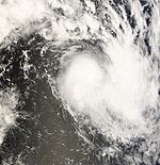
Moderate Tropical Storm Bernard (JTWC
designation: 03S; BoM designation: 01U was a weak and short lived tropical cyclone
which existed during mid-November 2008. The third tropical disturbance and second named storm of the 2008–09 South-West Indian Ocean cyclone season, Bernard developed out of a small area of low pressure
on November 15 located about 795 km (495 mi) east-southeast of Diego Garcia
. Traveling towards the east, the system gradually strengthened and was declared Tropical Disturbance 03-20082009 early on November 19. The disturbance strengthened into a depression the next day before briefly reaching moderate tropical storm status around 1200 UTC
on November 20. As the system began to accelerate, convection associated with it rapidly diminished and the storm dissipated early the next morning.
(JTWC) began monitoring an area of low pressure
accompanied by persistent convection
located about 795 km (495 mi) east-southeast of Diego Garcia
. The low was centered to the east of an upper-level ridge
axis within an area of moderate vertical wind shear
. With less than optimal conditions for development, the JTWC assessed the chances of the low developing into a tropical cyclone within 24 hours as "poor". Over the next several days, the system moved slowly in a general eastward direction with little development. On November 19, convection developed around the center of circulation
after being nearly stationary for a few days. At 0600 UTC
, the Regional Specialized Meteorological Centre
for the southwest Indian Ocean, Météo-France
, designated the system as Tropical Disturbance 03-20082009 while located about 695 km (430 mi) east-southeast of Diego Garcia. As convective banding features
and fair poleward outflow
developed, the JTWC issued a Tropical Cyclone Formation Alert
, stating that the disturbance was likely to develop into a tropical cyclone within 24 hours.
Later that day, Météo-France upgraded the disturbance to a tropical depression, as winds had increased to 55 km/h (35 mph 10-minute winds). At this time, the maximum radius of tropical depression-force winds was 50 km (30 mi). About three hours after being designated as a depression, the JTWC began issuing advisories on Tropical Cyclone 03S as they estimated winds to have reached 65 km/h (40 mph 1-minute winds). Although sea surface temperatures were supportive of development, moderate wind shear was forecast to prevent the system from significantly intensifying. Located to the northeast of a low to mid-level trough
and to the southwest of a near-equatorial ridge the system began to accelerate. At 0600 UTC on November 20, the JTWC assessed the system to have reached its peak intensity with winds of 75 km/h (45 mph 1-minute winds) while located 1,445 km (900 mi) west of the Cocos Islands. Shortly after, Météo-France upgraded the depression to a moderate tropical storm and gave it the name Bernard. Upon being named, Bernard reached its peak intensity with winds of 65 km/h (40 mph) with a minimum pressure of 994 hPa
(mbar
).
Just six hours after being named, Bernard was downgraded to a tropical depression as all deep convection associated with the system dissipated. The sudden decrease in convection was caused by the storms unusually fast movement of 50 km/h (31 mph) towards the east-southeast. In addition, the depression began moving over cooler sea surface temperatures, which would prevent a significant redevelopment of convection. At the same time Météo-France downgraded Bernard to a depression, the JTWC issued their final advisory on Tropical Cyclone 03S as it had weakened below tropical storm status. Early the next morning, Météo-France downgraded the system to a tropical disturbance and issued their final advisory on the dissipating cyclone. As Météo-France issued their final advisory, the remnants of Bernard entered Tropical Cyclone Warning Center in Jakarta's area of responsibility and was designated as Tropical Low 01U. However, this was the only advisory issued by Darwin as the low dissipated shortly after while located about 675 km (420 mi) west-northwest of the Cocos Islands.
Joint Typhoon Warning Center
The Joint Typhoon Warning Center is a joint United States Navy – United States Air Force task force located at the Naval Maritime Forecast Center in Pearl Harbor, Hawaii...
designation: 03S; BoM designation: 01U was a weak and short lived tropical cyclone
Tropical cyclone
A tropical cyclone is a storm system characterized by a large low-pressure center and numerous thunderstorms that produce strong winds and heavy rain. Tropical cyclones strengthen when water evaporated from the ocean is released as the saturated air rises, resulting in condensation of water vapor...
which existed during mid-November 2008. The third tropical disturbance and second named storm of the 2008–09 South-West Indian Ocean cyclone season, Bernard developed out of a small area of low pressure
Low pressure area
A low-pressure area, or "low", is a region where the atmospheric pressure at sea level is below that of surrounding locations. Low-pressure systems form under areas of wind divergence which occur in upper levels of the troposphere. The formation process of a low-pressure area is known as...
on November 15 located about 795 km (495 mi) east-southeast of Diego Garcia
Diego Garcia
Diego Garcia is a tropical, footprint-shaped coral atoll located south of the equator in the central Indian Ocean at 7 degrees, 26 minutes south latitude. It is part of the British Indian Ocean Territory [BIOT] and is positioned at 72°23' east longitude....
. Traveling towards the east, the system gradually strengthened and was declared Tropical Disturbance 03-20082009 early on November 19. The disturbance strengthened into a depression the next day before briefly reaching moderate tropical storm status around 1200 UTC
Coordinated Universal Time
Coordinated Universal Time is the primary time standard by which the world regulates clocks and time. It is one of several closely related successors to Greenwich Mean Time. Computer servers, online services and other entities that rely on having a universally accepted time use UTC for that purpose...
on November 20. As the system began to accelerate, convection associated with it rapidly diminished and the storm dissipated early the next morning.
Meteorological history
On November 15, the Joint Typhoon Warning CenterJoint Typhoon Warning Center
The Joint Typhoon Warning Center is a joint United States Navy – United States Air Force task force located at the Naval Maritime Forecast Center in Pearl Harbor, Hawaii...
(JTWC) began monitoring an area of low pressure
Low pressure area
A low-pressure area, or "low", is a region where the atmospheric pressure at sea level is below that of surrounding locations. Low-pressure systems form under areas of wind divergence which occur in upper levels of the troposphere. The formation process of a low-pressure area is known as...
accompanied by persistent convection
Atmospheric convection
Atmospheric convection is the result of a parcel-environment instability, or temperature difference, layer in the atmosphere. Different lapse rates within dry and moist air lead to instability. Mixing of air during the day which expands the height of the planetary boundary layer leads to...
located about 795 km (495 mi) east-southeast of Diego Garcia
Diego Garcia
Diego Garcia is a tropical, footprint-shaped coral atoll located south of the equator in the central Indian Ocean at 7 degrees, 26 minutes south latitude. It is part of the British Indian Ocean Territory [BIOT] and is positioned at 72°23' east longitude....
. The low was centered to the east of an upper-level ridge
High pressure area
A high-pressure area is a region where the atmospheric pressure at the surface of the planet is greater than its surrounding environment. Winds within high-pressure areas flow outward due to the higher density air near their center and friction with land...
axis within an area of moderate vertical wind shear
Wind shear
Wind shear, sometimes referred to as windshear or wind gradient, is a difference in wind speed and direction over a relatively short distance in the atmosphere...
. With less than optimal conditions for development, the JTWC assessed the chances of the low developing into a tropical cyclone within 24 hours as "poor". Over the next several days, the system moved slowly in a general eastward direction with little development. On November 19, convection developed around the center of circulation
Eye (cyclone)
The eye is a region of mostly calm weather found at the center of strong tropical cyclones. The eye of a storm is a roughly circular area and typically 30–65 km in diameter. It is surrounded by the eyewall, a ring of towering thunderstorms where the second most severe weather of a cyclone...
after being nearly stationary for a few days. At 0600 UTC
Coordinated Universal Time
Coordinated Universal Time is the primary time standard by which the world regulates clocks and time. It is one of several closely related successors to Greenwich Mean Time. Computer servers, online services and other entities that rely on having a universally accepted time use UTC for that purpose...
, the Regional Specialized Meteorological Centre
Regional Specialized Meteorological Centre
A Regional Specialized Meteorological Centre is responsible for the distribution of information, advisories, and warnings regarding the specific program they have a part of, agreed by consensus at the World Meteorological Organization as part of the World Weather Watch.-Tropical...
for the southwest Indian Ocean, Météo-France
Météo-France
Météo-France is the French national meteorological service.The organisation was established by decree in June 1993 and is a department of the Ministry of Transportation. It is headquartered in Paris but many domestic operations have been decentralised to Toulouse...
, designated the system as Tropical Disturbance 03-20082009 while located about 695 km (430 mi) east-southeast of Diego Garcia. As convective banding features
Rainband
A rainband is a cloud and precipitation structure associated with an area of rainfall which is significantly elongated. Rainbands can be stratiform or convective, and are generated by differences in temperature. When noted on weather radar imagery, this precipitation elongation is referred to as...
and fair poleward outflow
Outflow (meteorology)
Outflow, in meteorology, is air that flows outwards from a storm system. It is associated with ridging, or anticyclonic flow. In the low levels of the troposphere, outflow radiates from thunderstorms in the form of a wedge of rain-cooled air, which is visible as a thin rope-like cloud on weather...
developed, the JTWC issued a Tropical Cyclone Formation Alert
Tropical Cyclone Formation Alert
A Tropical Cyclone Formation Alert is a bulletin released by the U.S. Navy-operated Joint Typhoon Warning Center in Honolulu, Hawaii or the Naval Maritime Forecast Center in Norfolk, Virginia, warning of the possibility of a tropical cyclone forming from a tropical disturbance that has been...
, stating that the disturbance was likely to develop into a tropical cyclone within 24 hours.
Later that day, Météo-France upgraded the disturbance to a tropical depression, as winds had increased to 55 km/h (35 mph 10-minute winds). At this time, the maximum radius of tropical depression-force winds was 50 km (30 mi). About three hours after being designated as a depression, the JTWC began issuing advisories on Tropical Cyclone 03S as they estimated winds to have reached 65 km/h (40 mph 1-minute winds). Although sea surface temperatures were supportive of development, moderate wind shear was forecast to prevent the system from significantly intensifying. Located to the northeast of a low to mid-level trough
Trough (meteorology)
A trough is an elongated region of relatively low atmospheric pressure, often associated with fronts.Unlike fronts, there is not a universal symbol for a trough on a weather chart. The weather charts in some countries or regions mark troughs by a line. In the United States, a trough may be marked...
and to the southwest of a near-equatorial ridge the system began to accelerate. At 0600 UTC on November 20, the JTWC assessed the system to have reached its peak intensity with winds of 75 km/h (45 mph 1-minute winds) while located 1,445 km (900 mi) west of the Cocos Islands. Shortly after, Météo-France upgraded the depression to a moderate tropical storm and gave it the name Bernard. Upon being named, Bernard reached its peak intensity with winds of 65 km/h (40 mph) with a minimum pressure of 994 hPa
Pascal (unit)
The pascal is the SI derived unit of pressure, internal pressure, stress, Young's modulus and tensile strength, named after the French mathematician, physicist, inventor, writer, and philosopher Blaise Pascal. It is a measure of force per unit area, defined as one newton per square metre...
(mbar
Bar (unit)
The bar is a unit of pressure equal to 100 kilopascals, and roughly equal to the atmospheric pressure on Earth at sea level. Other units derived from the bar are the megabar , kilobar , decibar , centibar , and millibar...
).
Just six hours after being named, Bernard was downgraded to a tropical depression as all deep convection associated with the system dissipated. The sudden decrease in convection was caused by the storms unusually fast movement of 50 km/h (31 mph) towards the east-southeast. In addition, the depression began moving over cooler sea surface temperatures, which would prevent a significant redevelopment of convection. At the same time Météo-France downgraded Bernard to a depression, the JTWC issued their final advisory on Tropical Cyclone 03S as it had weakened below tropical storm status. Early the next morning, Météo-France downgraded the system to a tropical disturbance and issued their final advisory on the dissipating cyclone. As Météo-France issued their final advisory, the remnants of Bernard entered Tropical Cyclone Warning Center in Jakarta's area of responsibility and was designated as Tropical Low 01U. However, this was the only advisory issued by Darwin as the low dissipated shortly after while located about 675 km (420 mi) west-northwest of the Cocos Islands.
Impact
As Bernard remained out over open waters for the duration of its existence, there was no impact on any land-masses.See also
- 2008–09 South-West Indian Ocean cyclone season
- Timeline of the 2008–09 South-West Indian Ocean cyclone seasonTimeline of the 2008–09 South-West Indian Ocean cyclone seasonBelow is a timeline of the 2008–09 South-West Indian Ocean cyclone season, documenting storm formations, intensifcation, weakening, landfalls, extratropical transitions, as well as dissipation or leaving the area of responsibility....