All Topics  
Trat Province


   Email Print
   Bookmark   Link


Trat Province


Trat is a province
Provinces of Thailand

Thailand is divided into 75 provinces , which are geographically grouped into 6 regions. The capital Bangkok is not a province but a special administrative area and is included as the 76th province since it is administered at the same level as the other 75 provinces....
 (changwat) of Thailand
Thailand

The Kingdom of Thailand is an independent country that lies in the heart of Southeast Asia. It is bordered to the north by Laos and Myanmar, to the east by Laos and Cambodia, to the south by the Gulf of Thailand and Malaysia, and to the west by the Andaman Sea and Myanmar....
. It is located in the east of Thailand, and has borders with Chanthaburi Province
Chanthaburi Province

Chanthaburi is a Provinces of Thailand of Thailand. It is located in the east of Thailand, at the border to Battambang Province and Pailin of Cambodia and the shore to the Gulf of Thailand....
 to the northwest, Cambodia
Cambodia

The Kingdom of Cambodia is a country in South East Asia with a population of over 13 million people. The kingdom's capital and largest city is Phnom Penh....
 to the east, and the Gulf of Thailand
Gulf of Thailand

The Gulf of Thailand is a body of water that borders, but is not part of the South China Sea . The gulf is bordered by Cambodia, Thailand and Vietnam....
 to the south.

Trat is most famous for gemstone
Gemstone

A gemstone or gem, also called a precious or semi-precious stone, is a piece of attractive mineral, which — when cut and polished — is used to make jewellery or other adornments....
 mining and trading.

history of Trat can be traced back to the reign of King Prasat Thong
Prasat Thong

King Prasat Thong was the first king of Prasat Thong dynasty, the 4th dynasty of Ayutthaya kingdom. He was the Defense minister of King Songtham....
 of the Ayutthaya Kingdom
Ayutthaya kingdom

The kingdom of Ayutthaya was a Thai people kingdom that existed from 1351 to 1767. Ayutthaya was friendly towards foreign traders, including the Han Chinese, Vietnamese , Indo-Aryans, Japanese people and Persians, and later the Portuguese people, Spanish people, Dutch and French people, permitting them to set up villages outside the city wa...
. Formerly known as Mueang Thung Yai, Trat has played an important role in the development of country’s stability and economy due to its strategic location.


Discussion
Ask a question about 'Trat Province'
Start a new discussion about 'Trat Province'
Answer questions from other users
Full Discussion Forum


Encyclopedia


Trat is a province
Provinces of Thailand

Thailand is divided into 75 provinces , which are geographically grouped into 6 regions. The capital Bangkok is not a province but a special administrative area and is included as the 76th province since it is administered at the same level as the other 75 provinces....
 (changwat) of Thailand
Thailand

The Kingdom of Thailand is an independent country that lies in the heart of Southeast Asia. It is bordered to the north by Laos and Myanmar, to the east by Laos and Cambodia, to the south by the Gulf of Thailand and Malaysia, and to the west by the Andaman Sea and Myanmar....
. It is located in the east of Thailand, and has borders with Chanthaburi Province
Chanthaburi Province

Chanthaburi is a Provinces of Thailand of Thailand. It is located in the east of Thailand, at the border to Battambang Province and Pailin of Cambodia and the shore to the Gulf of Thailand....
 to the northwest, Cambodia
Cambodia

The Kingdom of Cambodia is a country in South East Asia with a population of over 13 million people. The kingdom's capital and largest city is Phnom Penh....
 to the east, and the Gulf of Thailand
Gulf of Thailand

The Gulf of Thailand is a body of water that borders, but is not part of the South China Sea . The gulf is bordered by Cambodia, Thailand and Vietnam....
 to the south.

Trat is most famous for gemstone
Gemstone

A gemstone or gem, also called a precious or semi-precious stone, is a piece of attractive mineral, which — when cut and polished — is used to make jewellery or other adornments....
 mining and trading.

History

The history of Trat can be traced back to the reign of King Prasat Thong
Prasat Thong

King Prasat Thong was the first king of Prasat Thong dynasty, the 4th dynasty of Ayutthaya kingdom. He was the Defense minister of King Songtham....
 of the Ayutthaya Kingdom
Ayutthaya kingdom

The kingdom of Ayutthaya was a Thai people kingdom that existed from 1351 to 1767. Ayutthaya was friendly towards foreign traders, including the Han Chinese, Vietnamese , Indo-Aryans, Japanese people and Persians, and later the Portuguese people, Spanish people, Dutch and French people, permitting them to set up villages outside the city wa...
. Formerly known as Mueang Thung Yai, Trat has played an important role in the development of country’s stability and economy due to its strategic location. The town of Trat has later become a community of Chinese Merchants.

Trat served as a checkpoint and buffer city in 1767 and was responsible for providing provisions to King Taksin
Taksin

Somdet Phrachao Taksin Maharaj or Somdet Phrachao Krung Thonburi ; ; Teochew: D?nchao; was the first and only monarch of Thonburi kingdom....
 the Great before he moved his navy from Chanthaburi to Ayutthaya
Ayutthaya (city)

Ayutthaya city is the capital of Ayutthaya province in Thailand. The city was founded in 1350 by King Ramathibodi I, who came here to escape a smallpox outbreak in Lop Buri, and proclaimed it the capital of his kingdom, often referred to as the Ayutthaya kingdom or Siam....
, where he expelled the Burmese
Bamar

The Bamar , are the dominant ethnic group of Burma, constituting approximately 68% of the population. However, there is some speculation that the government has slightly inflated this figure....
 and liberated the Kingdom from Burmese rule.

In Rattanakosin era, during the Paknam crisis in 1893 the French colonist army occupied the western part of Chantaburi. In 1904 in order to get back Chantaburi Siam had to give Trat to French Indochina
French Indochina

French Indochina was the part of the French colonial empire in Indochina in southeast Asia. A federation of the three Vietnamese regions, Tonkin, Annam, and Cochinchina, as well as Cambodia, was formed in 1887....
. Trat became part of Thailand again on March 23, 1906 in exchange for many areas east of the Mekong
Mekong

The Mekong River is one of the world?s major rivers. It is the 12th-longest river in the world, and 7th longest in Asia. . Its estimated length is , and it drains an area of ....
 river like Battambang
Battambang Province

Battambang is a provinces of Cambodia of Cambodia. It is in the northwest of the country, and its capital is Battambang. The name literally means loss of stick referring to a legend of Preah Bat Dambang Kranhoung ....
, Siam Nakhon
Siam Nakhon Province

Siam Nakhon is a Thai province which no longer exists. It was a changwat of Thailand located in previously-Cambodian territory, but was ceded to French Indochina in 1906....
 and Sisophon
Banteay Meanchey

Banteay Meanchey is a provinces of Cambodia. It is in the northwest of the country, and its capital is Sisophon. In the Khmer language, Banteay Meanchey means "Fortress of Victory"....
.

During the Indochina War, the French Navy tried to seize Trat again. The French – Thai Battle broke out on 5 January 1941. The battle ended 17 January at Ko Chang
Ko Chang

Ko Chang , also Koh Chang is the second largest island of Thailand , located on the Thai east coast 310 km away from Bangkok near the border to Cambodia in the Gulf of Thailand....
, when three Thai ships were sunk - the HTMS Chonburi, HTMS Songkhla and HTMS Thonburi. Later the Japanese ended the conflict by diplomacy.

Geography

The Cardamom mountain range
Cardamom Mountains

The Kr?vanh Mountains, or literally "Cardamom Mountains" , is a mountain range in the south west of Cambodia. The highest elevation is Phnom Aural at 1,813 meters high....
 forms the boundary to Cambodia in the east of the province, where Trat has borders with three Cambodian provinces: Battambang
Battambang Province

Battambang is a provinces of Cambodia of Cambodia. It is in the northwest of the country, and its capital is Battambang. The name literally means loss of stick referring to a legend of Preah Bat Dambang Kranhoung ....
, Pursat
Pursat Province

Pursat Province is the 4th largest provinces of Cambodia in Cambodia. It is located in the western part of the country and borders clockwise from the north with Battambang Province, the Tonl? Sap, Kampong Chhnang Province, Kampong Speu Province, Koh Kong Province, and Thailand....
 and Koh Kong
Koh Kong Province

Koh Kong is a provinces of Cambodia of Cambodia. The name means "Kong Island Province". Its capital is Koh Kong .The province is subdivided into 8 districts ....
.

The second biggest island
Island

An island or isle is any piece of land that is surrounded by water. Very small islands such as emergent land features on atolls are called islets....
 of Thailand is Ko Chang
Ko Chang

Ko Chang , also Koh Chang is the second largest island of Thailand , located on the Thai east coast 310 km away from Bangkok near the border to Cambodia in the Gulf of Thailand....
, belonging to the province. The island, together with more than 40 surrounding smaller islands, forms the Mu Ko Chang Marine National Park
List of national parks of Thailand

National parks in Thailand are defined as an area of least ten square kilometres that contains natural resources of ecological importance or unique beauty, or flora and fauna of special importance....
.

Other islands of the province include: Ko Kham
Ko Kham

Ko Kham is a small island near Ko Mak, on Trat Province, Thailand.It can be reached with a sea kayak from Ko Mak or by walking during low tide....
, Ko Mak
Ko Mak

Ko Mak is a small island of Trat Province, Thailand. This island is named after the Areca nut ....
, Ko Phi
Ko Phi

Ko Phi is a small unoccupied island near Ko Mak, in Trat Province, Thailand.It can be reached with a sea kayak from Ko Mak. Ko Phi has places to Snorkeling, depending on the direction of wind....
.

Approximate centre:

Symbols

Seal Trat
The provincial seal shows the sea with a mountain in the background.

Provincial tree is the Tropical almond (Terminalia catappa
Terminalia catappa

Terminalia catappa is a large Tropics tree in the Combretum imberbe family, Combretaceae. The tree has been spread widely by humans and the native range is uncertain....
).


Administration

Amphoe Trat
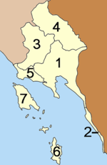
The province is subdivided in 7 districts (amphoe
Amphoe

An amphoe is the second level administrative subdivision of Thailand. Usually translated as district, amphoe make up the Provinces of Thailand....
). These are further subdivided into 38 subdistricts (tambon
Tambon

Tambon is a local government unit in Thailand. Below district and province , they form the third administrative subdivision level. As of the 2000 census there are 7254 tambon, not including the 154 khwaeng of Bangkok, which are set at the same administrative level, thus every Amphoe contains 8-10 tambon....
) and 254 villages (muban
Muban

Muban is the lowest Administrative divisions of Thailand. Usually translated as village, they are the subdivision of tambon. As of the census of 2000 there were 69,307 villages, including some villages in the more rural districts of Bangkok....
).
  1. Mueang Trat
    Amphoe Mueang Trat

    Mueang Trat is the capital district of Trat Province, eastern Thailand....
  2. Khlong Yai
    Amphoe Khlong Yai

    Khlong Yai is a district of Trat Province, eastern Thailand. A border crossing into Cambodia is located at Hat Lek, known as the Cham Yeam crossing in Koh Kong Province of Cambodia....
  3. Khao Saming
    Amphoe Khao Saming

    Khao Saming is a district in Trat Province, eastern Thailand....
  4. Bo Rai
  1. Laem Ngop
    Amphoe Laem Ngop

    Laem Ngop is a district of Trat Province, eastern Thailand....
  2. Ko Kut
    Ko Kut

    Ko Kut is a district of Trat Province, eastern Thailand, consisting of a group of islands. With a population of about 2000 it is the district with the lowest population of all Thailand....
  3. Ko Chang
    Ko Chang

    Ko Chang , also Koh Chang is the second largest island of Thailand , located on the Thai east coast 310 km away from Bangkok near the border to Cambodia in the Gulf of Thailand....


Tourism


Sights

Wat Buppharam (???????????) or Wat Plai Khlong (???????????) It is the province’s oldest temple built around the reign of King Prasat Thong (1648 A.D.). Lately, a temple museum was established and the temple’s landscape has been well tidied, so it has become a local religious centre. Wat Yotha Nimit (?????????????), also known as Wat Bot (????????), is the only royal temple in Trat. The temple was once used as a place to hold the oath of allegiance ceremony. There is an old ordination hall of Ayutthayan art serving as a Wihan called Wihan Yotha Nimit for storing many antiques.

City Pillar Shrine (???????????????????) It is different from other city pillar shrines because of its form as a Chinese pavilion. Every year on the sixth night of the waxing moon period of the sixth lunar month, there is a celebration called, Phli Mueang Day (??????????????) or known among the Chinese as Xia Gong Sae Yit (???????????????) which means the birthday of the City Pillar God.

Wat Phai Lom (??????????) It used to be a resident of Trat’s Father of Education–Than Chaokhun Phra Wimonmethachan Worayannurak. The temple also houses a Buddhist garden for public meditation and Chedi museum of three much revered monks of Trat.

Residang Kampot (??????????????????? ????????) a former residence now used as the Office of Probation, Department of Corrections, still in its original architectural style.

Laem Sok (???????) was used as the residence of Kromluang Chomphonkhetudomsak, the father of Thai Royal Navel Army. Fishermen villages are found nrae the area.

Wat Khiri Wihan (????????????) The temple features fine architecture with a blend of modern art. Principal buildings inside the temple’s precincts include a large Phra Ubosot or ordination hall, Phra Chedi, reception pavilion for HRH Princess Maha Chakri Sirindhorn, monk’s residence, preaching hall, and Chinese pavilion enshrining Phra Phuttha Udom Sombun, Bodhisattva Avalokitesvara, and Phra Sangkatchai.

Laem Klat (????????): A white sandy beach sticking out into the sea with not too deep water ideal for swimming.

Wat Saphan Hin (???????????) Although it is unknown when the temple was built, it is assumed to be more than a hundred years old. There is an old Buddhist ordination hall in the water, approximately 1 km. from the temple.

Hat Sai Ngam (??????????) an approximately 200-metre long white sandy beach running parallel to a grove of pine trees.

Hat Sai Ngoen (???????????) a not-so-wide beach with a pine forest more ideal for relaxing or fishing than swimming.

Hat Muk Kaeo and Hat Sai Kaeo (?????????? ??????????????) have a peaceful atmosphere for recreation. Hat Muk Kaeo is a white sandy beach, which lies along from Hat Sai Ngoen to Hat Sai Kaeo, with the shade of pine and coconut trees all along the beach.

Ratchakarun Thai Red Cross Association’s Khao Lan Center (??????????????? ??????????? ???????) Her Majesty the Queen ordered to establish to help Cambodian refugees. However, the center was closed in 1986 since all the refugees returned to their homeland. Hat Banchuen (??????????), formerly called Hat Maro (???????) This beach has delicate sand grain and clear sea water where it is possible to swim.

Thailand’s Narrowest Area (???????????????????????????) located at Mu 2 Ban Khot Sai, Tambon Hat Lek, on the Trat– Khlong Yai route between Km. 81–82. The area is only 450 metres wide.

Ban Hat Lek Border Market (?????????????????????) is a village on the Thai-Cambodian border. When fighting in Cambodia was over in 1986, it used to serve as an intermediate marketplace for grain trading between farmers in Cambodia and traders in Ko Kong.


Namtok Salatdai (???????????) is situated 7 kilometres from Km. 25 of Highway No. 3157 (Saen Tung-Bo Rai).

Namtok Khlong Kaeo National Park (???????????????????????????) has an area of approximately 65,525 rai (104,840 square kilometres). Interesting places is Namtok Khlong Kaeo.

Ban Nam Chiao (?????????????) It is noted for Ngop Nam Chiao, a native hat to ward off the sun. The hat is woven with local palm leafs from plants grown in mangrove area. It is still widely used today as it is light and comfortable.

Ko Chang Naval Battle Memorial (???????????????????????????) at Laem Ngop, commemorates the Franco-Thai naval engagement on January 17-21, 1941. There are also the Statue of Prince Chumphon, father of the Thai navy, and a warship-shaped museum displaying old equipment and armament of the fleet with exhibits on the Ko Chang naval battle.

Ko Pui (???????) an islet not too far from the shore that makes an ideal attraction for relaxation in shady surroundings. It is conveniently accessible in all seasons and home to coconut groves, herbs and Dinso Phong (white clay body-powder) mentioned at the time of King Rama V’s visit to Trat.

Ao Tan Khu (??????????) is a bay with fine sandy beach popular with local people during holidays.

Mu Ko Chang (????????????) located in the middle of the sea and, thus, having an averagely pleasant climate ideal for vacation. Ko Chang is influenced by monsoons from both the northeast and southwest winds, which bar boat access to the island during May–October.

Mu Ko Chang National Park (??????????????????????????), with an area of 650 square kilometres, covers more than 52 islands. The most famous is Ko Chang. In addition, there are other islands with remaining wonderful nature.

Ko Chang (????????) previously an unsettled island, is now important as a harbour for ships to escape from the monsoon, and dietary or fresh water resources. Ko Chang is the second largest island of the country. The topography contains high mountains and complex stone cliffs.

Ko Chang Naval Battle Site (??????????????????????) The Trat waters near Ao Salak Phet and Ao Salak Khok also added another page in the Thai history of fighting for the country’s sovereignty. 17 January has become a memorial day for the heroic fighting, of which a service is held annually at Ko Chang Naval Battle Memorial in Amphoe Laem Ngop.

Ko Ngam was the first point of confrontation in the Franco–Siamese War in which the French army sent aircraft on a reconnaissance and bombing of the island, whereas Ko Wai is the point where French patrol aircraft crashed after being fired by HTMS Songkhla and HTMS Chon Buri.

Ko Mai Si is a small private island where there is beautiful nature, sandy beaches and clear water –home to diversified marine life and ideal for diving. Various plant species grow wild on the island, which used to be a confrontation site between the Lamotte Piquet and HTMS Thon Buri that was in commission at Ko Lim.

Ao Khlong Son (??????????): A bay in the northernmost west of the island where Ban Khlong Son Community is located, with a beautiful coral reef.

Namtok Khlong Nonsi (??????????????): A small waterfall to the northeast of the island accessible by a 3-km. pathway from Ban Dan Mai or about 4 km. from the national park’s headquarters.

Namtok Than Mayom (????????????) a medium 4-tiered waterfall located some 500 metres through a garden behind the national park’s headquarters, with the 3rd tier being the most beautiful.

Namtok Khlong Phlu (????????????): A large and most breathtaking waterfall on Ko Chang with water cascading down 3 tiers of the cliff to a basin, with an entrance located 3 km. from Ao Khlong Phrao.

Hat Sai Yao (??????????) located near Ao Salak Phet to the south of the island with a long stretch of sandy beach.

Monkey Training Centre (??????????????) located at Hat Sai Khao, the centre provides training as well as shows of monkey’s abilities, especially in collecting coconuts.

Ban Salak Phet (????????????) a large and the oldest community on Ko Chang located in the southern part. The villagers’ main occupation is coastal fishery in an advantageous area sheltered from winds and storms by islands and mountains. There is an old temple in front of the village known as Wat Salak Phet.

Namtok Khiri Phet (?????????????) a single-storeyed waterfall located 3 km. from Ban Salak Phet Community through a rubber plantation.

Namtok Khlong Nueng (??????????????) a small waterfall near Namtok Khiri Phet – Ban Rong Than, located some 2 km. deeper inside the island from the Salak Phet Community with another 480-metre walk. The waterfall cascades down from a narrow gorge for 120 metres.

Bang Bao Fishery Village (????????????????????) a village of houses on stilts built into the sea with bridges connecting them together. Most of the villagers are descendants of the Salak Phet villagers. The area is an ideal berthing area for fishing boats, with mountains and islands providing a good shelter from wind and storms in the monsoon season.

Ban Rong Than (???????????) a small community located near Salak Phet in the southern part of the island. It is a scenic viewpoint where the mist-covered peak of Khao Salak Phet in the north and Ko Maphrao Nai and mountains near Laem Yai in the east are visible.

Ao Bai Lan (?????????) located next to Hat Kai Bae.

Hat Kai Bae (?????????) a sloping and long stretch of beach connecting with Hat Khlong Phrao.

Ko Chang Noi and Laem Chang Noi (???????????????????????????) located in the north of Ko Chang and housing coral reefs between Laem Chang Noi and Ko Chang Noi.

Ko Man Nok–Ko Man Nai (??????????–?????????) small islands opposite Hat Kai Bae with surrounding beaches at low tides and golden seaweeds in the nearby shallows.

Ko Khlum (?????????) an island ideal for fishing with a peculiar scenery of rocky areas.

Ko Lao Ya (??????????) a group of islands located to the south of Ko Chang comprising Ko Lao Ya Nai, Ko Lao Ya Klang and Ko Lao Ya Nok.

Ko Wai (????????) The bay to the north of the island houses coral reefs in a perfect condition whereas the western area of Ao Yai provides home to mostly hard corals and scaly giant clams.

Ko Phrao Nok or Ko Sai Khao (???????????? ???? ???????????) located to the south facing Ao Salak Phet. The island has white sandy beaches and shady coconut grove.

Ko Ngam (????????) a twin island connected by a large sand bar located to the southeast of Ko Chang, with an inlet surrounded by the hilly topography where the sea is calm and scenic.

Ko Kut (???????) Thailand’s easternmost island in Trat waters, the province’s second largest island next to Ko Chang and the country’s fourth largest island. The topography is generally still in its natural condition, with mountains and ridges forming the headwater of many streams from which originate various waterfalls. The most renowned waterfall on Ko Kut is Namtok Wang Chao.

Ko Mak (????????) The topography is mostly coastal plain with a thicket of coconut groves and rubber plantations. Scenic bays and sandy beaches embracing crystal clear water are all around the island such as Ao Ta Nit, Ao Prong, Ao Phat and Ao Daeng

Ko Kradat (??????????) It has a flat paper-like topography with Alocasia plants–‘Kradat’ in Thai–growing wild in abundance. The island has a long and white sandy beach with beautiful coral reefs.

Mu Ko Rayang (??????????????) a group of islands comprising Ko Rayang Nai and Ko Rayang Nok. Ko Rayang Nok is peaceful with white sandy beaches and crystal clear water.

Mu Ko Kra (???????????) a group of islets to the west of Ko Mak, a swallow bird’s nest concession area and a diving spot with beautiful corals.

Mu Ko Rang (???????????) a group of islets located approximately 6 km. to the west of Ko Mak. There is not sufficient plains area for human habitation on Ko Rang, which is surrounded by islands of various sizes.

Local Products

Ruby (???????) Trat has been renowned for its precious red gemstone known as ‘Siamese Ruby’. However, as gemstones in the province begin to reduce, the Siamese ruby is now becoming rare.

Ngop Nam Chiao (????????????) a folk-style hand-made palm leaf hat identified with the Nam Chiao community. The hat is made into a distinct shape looking like an overturned frying pan or soldier’s hat in former times.

Rakam Wan (????????) a sweet variety of zalacca which is the most famous fruits out of the province’s vast array of fruit produce.

Trat Si Thong Pineapple (????????????????) a sweet and crispy variety of Trat’s juicy pineapple with yellowish skin. Seafood Products (??????????????????) dried fish and shrimp shrimp paste, processed food.

Namman Lueang (Yellow Oil) (????????????) herbal rubbing oil produced out of folk wisdom since ancient times. The aromatic vapourizing oil helps to relieve muscular pain, stiffness, dizziness, congested nose and cold.

Thai Ridgeback Dog (?????????????????????) distinctive by its ridged back, smartness and honesty.

Local fighting cock (??????????????) is a breed of cock famous for its talent and good tactics in fighting inhabiting Trat.

Culture


Festivals


The Ko Chang Naval Battle Day (?????????????????????????????????????????????) is organised in late January at the Ko Chang Naval Battle Monument (Anuson Yutthanawi) at Laem Ngop. The event is to commemorate the bravery of the Royal Thai Navy’s action against the French on January 17-21, 1941. Merit-making and tribute rites are performed and there is exhibition by the Royal Thai Navy.

Trat Independence Day (???????????????), on March 23-27, marks the day the province returned to Thai sovereignty after the French occupation. The celebrations are held at the provincial town hall.

Trivia


  • Trat is the only province of Thailand that shares a land border with only one other Thai province (Chanthaburi).
  • Bangkok Senator Nitiphoom Naowarat
    Nitiphoom Naowarat

    Nitipoom Navaratna , , : born 1960, is a columnist. He also got the most voted senator in the year 2006.Biography of Nitipoom Navaratna...
     is from Trat.


External links