
Ko Chang
Encyclopedia
Ko Chang is the third largest island of Thailand
(largest island in the Ko Chang Marine Park archipelago), located on the Thai east coast 310 km away from Bangkok near the border to Cambodia
in the Gulf of Thailand
. The name means Elephant Island. Ko Chang was named for the elephant shape of its headland, although elephants
are not indigenous to the island. At present, there are eight village
s in total. It is a mountainous island and Khao Salak Phet is the highest peak of all at 744 metres. The island is known for several waterfall
s, thriving coral reef
s and rainforest
s. The island has an area of approximately 217 square kilometers.
s to escape from the monsoon
, and dietary or fresh water resources, especially at Ao Salak Phet or Ao Salat which is well known to pirates, Hai Lam
Chinese and Vietnamese.
The island is part of the Mu Ko Chang National Park
. During World War II
, when Thailand was occupied by Japanese forces, Ko Chang was the scene of a naval battle
between the reluctant Royal Thai Navy
and a Vichy France
squadron, in which the Thais were decisively beaten.
Until the mid-1980s the infrastructure on the island was undeveloped, but tourism
has increased significantly since then. Around the year 2000, malaria
was eradicated, the area became a national park
(and began charging entry fees). The island now receives 655,000 visitors annually, about two thirds of them Thai. Ko Chang is one of the few places with virgin forest, but the mad rush to cash in on tourism has had a heavy toll on its virgin forests. Nowadays there are also numerous resorts all over the island. Land prices have been up since then.
Prior to World War II, Ko Chang was little known by anyone. During this period, the few families there made a living growing coconuts and fruit on the mainland. In January 1941, during the Japanese occupation, the Thai Navy fought the French in a battle in the waters to the south-east of Ko Chang. It was the French who were the victors after the Thai naval ship was sunk.
Nothing else happened to Ko Chang until the first backpacker foreigners started arriving on the back of local fishing boats in the mid-1970s. In 1982, Ko Chang along with surrounding area became part of the protected Mu Chang Marine. Only very recently, in less than ten years, Ko Chang has turned itself in to a major tourist destination in Thailand
, both for foreigners and local Thais.
This sudden tourism boom however, has been hampered by controversy concerning land encroachment etcetera.
The island is about 30 km long and almost 14 km wide, totaling 217 km². The national marine park covers of 650 km² of which 70 % is offshore. The interior of the island is mountainous, covered by tropical rain forest. The highest elevation measuring 743m is Khao Salak Phet. There are plenty of sandy beaches on the island, dotted with hotels and resorts.
The west coast settlements of Hat Sai Khao, Hat Kai Mook and Hat Ta Nam attract most of the tourists. The village of Laem Bang Bao on the south coast is also a favored destination. There is a single road linking the west coast. The remaining roads on the west coast have a high gradient, while the topography of the east coast prohibits roads. Most buildings are wooden stilt houses. The island is mostly reached by a ferry departing from Laem Ngop near Trat
.

) in the province of Trat. It was formed on April 30, 1994, when it was split off from Laem Ngop district
, at first being a minor district (King Amphoe).
Following a decision of the Thai government on May 15, 2007, all of the 81 minor districts were to be upgraded to full districts. With the publishing in the Royal Gazette on August 24 the upgrade became official
.
The district is subdivided into two subdistricts (tambon
), which are further subdivided into 9 villages (muban
). There are no municipal (thesaban
) areas, and 2 Tambon administrative organizations (TAO).
Ko Chang consists of the following villages:
Due to its location and being an island, Ko Chang does get more than its fair share of rain, 4,000 mm per year.
Ko Chang has no airport. The nearest airport is in Amphoe Muang Trat on the mainland. Koh Chang Air Taxi however, does offer scenic seaplane service.
Roads
There are only two main roads on Ko Chang, one on the east coast and one on the west coast. Both roads start at Ao Sapparot in the north near the ferry piers. The two main roads run the entirety of the coastlines. There are also shorter roads which branch out to Ploytalay Resort and Keereephet, Khlong Nueng and Klong Phu Waterfalls.
Ferry Boat
At Laem Ngob in Trat Town opposite Ko Chang there are 3 piers offering ferry service to Ko Chang.
Motorbike
These can be either hired or taxied out. The island is full of both motorbike rental places and motorbike-taxi drivers.
Songthaew (public passenger pick-up vehicle)
These run up and down the two main roads and can either be used as public transport or privately hired.
Long-tail Boat
Tourists enjoy hiring long-tail boats to take them to nearby islands.
Some critics, however, worry that the Ko Chang tourism boom won’t survive as they believe that ‘gross over-development will only, over time, frighten off tourists to one of the other more unspoilt islands nearby.
Investors though, claim that what they are now doing in Ko Chang is nothing on the scale of the likes of Samui.
With the development of Ko Kong in Cambodia as a casino resort, it makes Ko Chang even more of an ideal place for a stop-over between the two islands.
This so called tourism boom is relative to a small base. Tourist numbers are a lot less than Samui or Phuket and approx 2/3 of the visitors are Thai.
, the small Indian Civet
, the Javan Mongoose, and 61 resident bird species. The Koh Chang Wart Frog (Limnonectes kohchangae) was originally thought to be an endemic species, but has now been found on the mainland as well.
Klong Plu (น้ำตกคลองพลู) - the most popular, and the only one on the west side of the island. Namtok Khlong Phlu is a large and most breathtaking waterfall on Ko Chang with water cascading down 3 tiers of the cliff to a basin, with an entrance located 3 km. from Ao Khlong Phrao.
Ban Salak Phet (บ้านสลักเพชร) the largest and oldest community on Ko Chang located in the southern part. The villagers’ main occupation is coastal fishery in an advantageous area sheltered from winds and storms by islands and mountains. There is an old temple in front of the village known as Wat Salak Phet built in the reign of King Rama V on his royal visit to the island. Ao Salak Phet is the largest bay on the island.
Bang Bao Fishery Village at Bang Bao Beach(หมู่บ้านประมงบางเบ้า) a village of houses on stilts built into the sea with bridges connecting them together. The villagers still live a simple way of life earning their living from coastal fishery. In the vicinity there is an abundance of cuttlefish and corals.
Ao Bai Lan (อ่าวใบลาน) located next to Hat Kai Bae and accessible by a pathway across the mountain has a scenic view of mountains along the way.
Hat Kai Bae (หาดไก่แบ้) a sloping and long stretch of beach connecting with Hat Khlong Phrao, suitable for swimming.
Hat Khlong Phrao- Laem Chaiyachet (หาดคลองพร้าว-แหลมไชยเชษฐ์) a long stretch of sloping beach connecting with Hat Kai Bae where swimming is possible. The northernmost end of Ao Khlong Phrao connects with Laem Chaiyachet with a scenic rocky cape but swimming is not possible.
Laem Chaichet nestling between White Sand and Klong Prao beaches is a popular place to see the sunset and admire Klong Prao’s natural surroundings. Activities to do here include: snorkeling, kayaking and fishing.
White Sand Beach is one of the island’s longest beaches that attracts a lot of visitors. At the back or the beach are orchards of coconut trees and forests.
Hiking on Ko Chang is popular due to the natural pristine surroundings including waterfalls, especially the routes Klong Son to Kai Bae and Kai Bae to Bang Bao.
Mountain Biking
Mountain bikes are available to rent at Hat Sai Khao and Hat Kaibae.
Elephant Trekking
Elephant Trekking is possible at the Ban Kwan Chang Elephant Camp at Klong Son, it is supported by the Asian Elephant Foundation to provide a natural environment for elephants and their mahouts.
Canoeing
Canoeing through the mangrove forests is most popular.
Diving & Snorkeling
This area does not have deep diving as in the west coast, but some very nice coral dives and a good variation in fish life. There are quite a lot of dive sites. There are several diving schools offering day trips and courses for different levels. For e.g.: Koh Rang national park has sites as Koh Laun, koh tong lang, Hin Kuak Maa, koh yak, koh thain. Then there are sites closer to Koh Chang, such as Hin Luk Bath, Hin Rap South, Hin Run Tek, Hin tai nam.
Spa
Ko Chang has plenty of spas offering various forms of massage, aromatherapy, herbal scrub, and reflexology. Spa service is found at many of the top resorts and hotels.
Located in Nam Chieo district is a cottage industry which produces ‘ngop’ (traditional Thai farming hat).
Baan Bang Bao or Bang Bao Fishery Village is unique in that every dwelling was built in the sea. There are small bridges connecting each one. Some of the abodes have been transformed into guesthouses and seafood restaurants.
Baan Khlong Son or Khlong Son Village has rubber plantations, orchards and traditional fishery. For tourists there are fishing tours, squid fishing or snorkeling to view schools of fishes on Koh Mapring and Koh Chang Noi nearby.
Baan Dan Kao or Dan Kao Village has indigenous folk of Koh Chang Noi who rear the fish in floating baskets especially “Yamsawat Fish” or Blue Spotted Sea Bass which are popular among the locals who prefer to eat live fish.
Baan Dan Mai(Dan Mai Village) and Baan Khlong Non Si (Khlong Non Si Village) have orchards, coconut plantations and traditional fishery. The lychee trees grown here are the traditional breed called “Silaman 200 years”. This breed of lychee tree has the large size and it is believed to be found on Koh Chang Noi only.
Baan Salak Petch or Salak Petch villagers mainly work about coastal fishery. Most houses were built in the sea like those in Bang Bao Village but it is a bigger community. Every house is connected with the wood bridge.
Baan Rong Than or Rong Than Village is an area which used to be the sites, owned by most villagers, for charcoal making from mangrove wood.
Baan Jek Bae or Jek Bae villagers work about traditional fishery, rubber plantation and coconut plantation.
The Ko Chang Yutthanavi Day is organized in late January at the Ko Chang Yutthanavi Memorial on Laem Ngop. The event commemorates the Royal Thai Navy’s fight against the French on January 17, 1941. There is an exhibition by the Royal Thai Navy and merit-making and tribute rites are performed.
Landline telephone, satellite telephone system, mobile phones and internet connection are available on Koh Chang. And, there is a Post Office on the island.
Thailand
Thailand , officially the Kingdom of Thailand , formerly known as Siam , is a country located at the centre of the Indochina peninsula and Southeast Asia. It is bordered to the north by Burma and Laos, to the east by Laos and Cambodia, to the south by the Gulf of Thailand and Malaysia, and to the...
(largest island in the Ko Chang Marine Park archipelago), located on the Thai east coast 310 km away from Bangkok near the border to Cambodia
Cambodia
Cambodia , officially known as the Kingdom of Cambodia, is a country located in the southern portion of the Indochina Peninsula in Southeast Asia...
in the Gulf of Thailand
Gulf of Thailand
The Gulf of Thailand , also known in to Malays as Teluk Siam literally meant Gulf of Siam, is a shallow arm of the South China Sea.-Geography:...
. The name means Elephant Island. Ko Chang was named for the elephant shape of its headland, although elephants
Asian Elephant
The Asian or Asiatic elephant is the only living species of the genus Elephas and distributed in Southeast Asia from India in the west to Borneo in the east. Three subspecies are recognized — Elephas maximus maximus from Sri Lanka, the Indian elephant or E. m. indicus from mainland Asia, and E. m....
are not indigenous to the island. At present, there are eight village
Village
A village is a clustered human settlement or community, larger than a hamlet with the population ranging from a few hundred to a few thousand , Though often located in rural areas, the term urban village is also applied to certain urban neighbourhoods, such as the West Village in Manhattan, New...
s in total. It is a mountainous island and Khao Salak Phet is the highest peak of all at 744 metres. The island is known for several waterfall
Waterfall
A waterfall is a place where flowing water rapidly drops in elevation as it flows over a steep region or a cliff.-Formation:Waterfalls are commonly formed when a river is young. At these times the channel is often narrow and deep. When the river courses over resistant bedrock, erosion happens...
s, thriving coral reef
Coral reef
Coral reefs are underwater structures made from calcium carbonate secreted by corals. Coral reefs are colonies of tiny living animals found in marine waters that contain few nutrients. Most coral reefs are built from stony corals, which in turn consist of polyps that cluster in groups. The polyps...
s and rainforest
Rainforest
Rainforests are forests characterized by high rainfall, with definitions based on a minimum normal annual rainfall of 1750-2000 mm...
s. The island has an area of approximately 217 square kilometers.
History
Ko Chang was an unsettled island in the past but it is now important as a harbour for shipShip
Since the end of the age of sail a ship has been any large buoyant marine vessel. Ships are generally distinguished from boats based on size and cargo or passenger capacity. Ships are used on lakes, seas, and rivers for a variety of activities, such as the transport of people or goods, fishing,...
s to escape from the monsoon
Monsoon
Monsoon is traditionally defined as a seasonal reversing wind accompanied by corresponding changes in precipitation, but is now used to describe seasonal changes in atmospheric circulation and precipitation associated with the asymmetric heating of land and sea...
, and dietary or fresh water resources, especially at Ao Salak Phet or Ao Salat which is well known to pirates, Hai Lam
Hai Lam
Hai Lam is an Norwegian football defender who currently plays for Ham-Kam.He was born in Hamar, joined the senior team of Hamarkameratene from the club's own junior ranks in 2001, and made his league debut on 12 June 2001 against FK Oslo Øst. He later played with Hamarkameratene in the Norwegian...
Chinese and Vietnamese.
The island is part of the Mu Ko Chang National Park
Mu Ko Chang National Park
Mu Ko Chang National Park is located in Ko Chang District, Trat Province, eastern Thailand. It is a marine national park with an area of , covering more than 52 islands. The most notable island within the archipelago is Ko Chang. Established in 1982, it is an IUCN Category II protected area with...
. During World War II
World War II
World War II, or the Second World War , was a global conflict lasting from 1939 to 1945, involving most of the world's nations—including all of the great powers—eventually forming two opposing military alliances: the Allies and the Axis...
, when Thailand was occupied by Japanese forces, Ko Chang was the scene of a naval battle
Battle of Koh Chang
The Battle of Koh Chang took place on 17 January 1941 during the French-Thai War and resulted in a decisive victory by the French over the Royal Thai Navy. During the battle, a flotilla of French warships attacked a smaller force of Thai vessels, including a coastal battleship.In the end, Thailand...
between the reluctant Royal Thai Navy
Royal Thai Navy
The Royal Thai Navy is the navy of Thailand and part of the Royal Thai Armed Forces, it was established in the late 19th century. Admiral Prince Abhakara Kiartiwongse is "The Father of Royal Thai Navy". Similar to the organizational structure of the United States, the Royal Thai Navy includes the...
and a Vichy France
Vichy France
Vichy France, Vichy Regime, or Vichy Government, are common terms used to describe the government of France that collaborated with the Axis powers from July 1940 to August 1944. This government succeeded the Third Republic and preceded the Provisional Government of the French Republic...
squadron, in which the Thais were decisively beaten.
Until the mid-1980s the infrastructure on the island was undeveloped, but tourism
Tourism
Tourism is travel for recreational, leisure or business purposes. The World Tourism Organization defines tourists as people "traveling to and staying in places outside their usual environment for not more than one consecutive year for leisure, business and other purposes".Tourism has become a...
has increased significantly since then. Around the year 2000, malaria
Malaria
Malaria is a mosquito-borne infectious disease of humans and other animals caused by eukaryotic protists of the genus Plasmodium. The disease results from the multiplication of Plasmodium parasites within red blood cells, causing symptoms that typically include fever and headache, in severe cases...
was eradicated, the area became a national park
National park
A national park is a reserve of natural, semi-natural, or developed land that a sovereign state declares or owns. Although individual nations designate their own national parks differently A national park is a reserve of natural, semi-natural, or developed land that a sovereign state declares or...
(and began charging entry fees). The island now receives 655,000 visitors annually, about two thirds of them Thai. Ko Chang is one of the few places with virgin forest, but the mad rush to cash in on tourism has had a heavy toll on its virgin forests. Nowadays there are also numerous resorts all over the island. Land prices have been up since then.
Prior to World War II, Ko Chang was little known by anyone. During this period, the few families there made a living growing coconuts and fruit on the mainland. In January 1941, during the Japanese occupation, the Thai Navy fought the French in a battle in the waters to the south-east of Ko Chang. It was the French who were the victors after the Thai naval ship was sunk.
Nothing else happened to Ko Chang until the first backpacker foreigners started arriving on the back of local fishing boats in the mid-1970s. In 1982, Ko Chang along with surrounding area became part of the protected Mu Chang Marine. Only very recently, in less than ten years, Ko Chang has turned itself in to a major tourist destination in Thailand
Tourism in Thailand
Tourism is a major economic factor in the Kingdom of Thailand, contributing an estimated 6.7% to Thailand's GDP in 2007.-Overview:Among the reasons for the increase in tourism in the 1960s were the stable political atmosphere and the development of Bangkok as a crossroads of international air...
, both for foreigners and local Thais.
This sudden tourism boom however, has been hampered by controversy concerning land encroachment etcetera.
Geography
The topography contains high mountains and complex stone cliffs.The island is about 30 km long and almost 14 km wide, totaling 217 km². The national marine park covers of 650 km² of which 70 % is offshore. The interior of the island is mountainous, covered by tropical rain forest. The highest elevation measuring 743m is Khao Salak Phet. There are plenty of sandy beaches on the island, dotted with hotels and resorts.
The west coast settlements of Hat Sai Khao, Hat Kai Mook and Hat Ta Nam attract most of the tourists. The village of Laem Bang Bao on the south coast is also a favored destination. There is a single road linking the west coast. The remaining roads on the west coast have a high gradient, while the topography of the east coast prohibits roads. Most buildings are wooden stilt houses. The island is mostly reached by a ferry departing from Laem Ngop near Trat
Trat
Trat is a town in Thailand, capital of Trat Province and the Mueang Trat district. The town is located in the east of Thailand, at the mouth of the Trat River, near the border with Cambodia.-Travel and Accommodation:...
.
Administration
The island forms a district (AmphoeAmphoe
An amphoe is the second level administrative subdivision of Thailand. Usually translated as district, amphoe make up the provinces, and are analogous to a county seat...
) in the province of Trat. It was formed on April 30, 1994, when it was split off from Laem Ngop district
Amphoe Laem Ngop
-History:The district was established in 1897 named Ko Chang district. The district office was located in Ban Dan Kao on Ko Chang. The district controlled all islands in Trat province. As the district office was located on an island, it was not convenient for most of people on mainland, thus the...
, at first being a minor district (King Amphoe).
Following a decision of the Thai government on May 15, 2007, all of the 81 minor districts were to be upgraded to full districts. With the publishing in the Royal Gazette on August 24 the upgrade became official
.
The district is subdivided into two subdistricts (tambon
Tambon
Tambon is a local government unit in Thailand. Below district and province , they form the third administrative subdivision level. As of the 2009 there are 7255 tambon, not including the 169 khwaeng of Bangkok, which are set at the same administrative level, thus every district contains 8-10 tambon...
), which are further subdivided into 9 villages (muban
Muban
Muban is the lowest administrative subdivision of Thailand. Usually translated as village, they are the subdivision of tambon. As of 2008, there are 74944 administrative villages in Thailand. As of the 1990 census, the average village consisted of 144 households or 746 persons.A muban does not...
). There are no municipal (thesaban
Thesaban
Thesaban are the municipalities in Thailand. There are three levels of municipalities - city, town and subdistrict municipality. Both Bangkok and Pattaya are special municipal entities outside the thesaban system....
) areas, and 2 Tambon administrative organizations (TAO).
| Nr. | Name | Thai name | Villages | Inh. Population A population is all the organisms that both belong to the same group or species and live in the same geographical area. The area that is used to define a sexual population is such that inter-breeding is possible between any pair within the area and more probable than cross-breeding with individuals... |
|
|---|---|---|---|---|---|
| 1. | Ko Chang | เกาะช้าง | 4 | 3010 | |
| 2. | Ko Chang Tai | เกาะช้างใต้ | 5 | 2346 |
Ko Chang consists of the following villages:
- Salak Phet
- Salak Phet Nuea
- Salak Khok
- Chek Bae
- Ban Dan Mai
- Bang Bao
- Khlong Son
- Khlong Phrao
- Khlong Nonsi
Boundary
Ko Chang is surrounded by 51 islands. To the east of the area lies Cambodia and to the west, the Thai province of Chanthaburi.Climate
Ko Chang has three seasons, they are:- Cool season (Nov-Feb)
- Hot season (March-May)
- Rainy season ( June-Oct
Due to its location and being an island, Ko Chang does get more than its fair share of rain, 4,000 mm per year.
Transportation
AirKo Chang has no airport. The nearest airport is in Amphoe Muang Trat on the mainland. Koh Chang Air Taxi however, does offer scenic seaplane service.
Roads
There are only two main roads on Ko Chang, one on the east coast and one on the west coast. Both roads start at Ao Sapparot in the north near the ferry piers. The two main roads run the entirety of the coastlines. There are also shorter roads which branch out to Ploytalay Resort and Keereephet, Khlong Nueng and Klong Phu Waterfalls.
Ferry Boat
At Laem Ngob in Trat Town opposite Ko Chang there are 3 piers offering ferry service to Ko Chang.
- Located at Ao Thammachat, the ferries depart daily at Ao Sapparot pier.
- Located at Center Point Pier, ferries are hourly to Dan Kao Pier.
- Laem Ngob Pier has less frequent ferries.
Motorbike
These can be either hired or taxied out. The island is full of both motorbike rental places and motorbike-taxi drivers.
Songthaew (public passenger pick-up vehicle)
These run up and down the two main roads and can either be used as public transport or privately hired.
Long-tail Boat
Tourists enjoy hiring long-tail boats to take them to nearby islands.
Tourism
The recent success of Ko Chang as a serious tourist destination has been quite phenomenal. But it remains a lot more peaceful and less developed than islands like Samui and Phuket. It's some 5 hours from Bangkok by bus and there's no airport on the island yet so it should remain more tranquil than Samui or Phuket. Ko Chang too is one of Thailand's most beautiful islands with some white sandy beaches, some half deserted. Some of the beaches are rocky in parts though so it doesn't have ideal swimming beaches like Phuket. The island is also home to a wide range of wildlife, including a good selection of birds, snakes, deer and a number of elephants. The island and its vicinity are great places for snorkeling, diving and jungle hiking.Some critics, however, worry that the Ko Chang tourism boom won’t survive as they believe that ‘gross over-development will only, over time, frighten off tourists to one of the other more unspoilt islands nearby.
Investors though, claim that what they are now doing in Ko Chang is nothing on the scale of the likes of Samui.
With the development of Ko Kong in Cambodia as a casino resort, it makes Ko Chang even more of an ideal place for a stop-over between the two islands.
This so called tourism boom is relative to a small base. Tourist numbers are a lot less than Samui or Phuket and approx 2/3 of the visitors are Thai.
Sights
In 1982 the island together with 51 more surrounding small islands was protected as the Mu Ko Chang Marine National Park. About 85% of the island is part of the national park, mostly the rain forest in the interior of the island. Nearby coral reefs are also contained within the National Park. Notable animals in the park include the stump-tailed MacaqueStump-tailed Macaque
The stump-tailed macaque , also called the bear macaque, is a species of macaque found in Southern Asia. In India, it is found in south of the Brahmaputra river, in northeastern part of the country.Its range in India extends from Assam and Meghalaya to eastern Aruanchal Pradesh, Nagaland, Manipur,...
, the small Indian Civet
Small Indian Civet
The Small Indian Civet or Rasse is a species of civet found across south and South-east Asia as well as in the Indonesian archipelago. The Assamese name Johamaal refers to its glandular odour similar to a scented rice variety called Joha...
, the Javan Mongoose, and 61 resident bird species. The Koh Chang Wart Frog (Limnonectes kohchangae) was originally thought to be an endemic species, but has now been found on the mainland as well.
Klong Plu (น้ำตกคลองพลู) - the most popular, and the only one on the west side of the island. Namtok Khlong Phlu is a large and most breathtaking waterfall on Ko Chang with water cascading down 3 tiers of the cliff to a basin, with an entrance located 3 km. from Ao Khlong Phrao.
- Klong Nonsi - on the east side of the island
- Klong Nueng - said to be the most breathtaking
- Khiri Petch - medium sized, about 3 kilometers from Salak Petch village
- Kongoi - 5 waterfalls near Bangbao
- The Thanmayom - near Thanmayom pier
Ban Salak Phet (บ้านสลักเพชร) the largest and oldest community on Ko Chang located in the southern part. The villagers’ main occupation is coastal fishery in an advantageous area sheltered from winds and storms by islands and mountains. There is an old temple in front of the village known as Wat Salak Phet built in the reign of King Rama V on his royal visit to the island. Ao Salak Phet is the largest bay on the island.
Bang Bao Fishery Village at Bang Bao Beach(หมู่บ้านประมงบางเบ้า) a village of houses on stilts built into the sea with bridges connecting them together. The villagers still live a simple way of life earning their living from coastal fishery. In the vicinity there is an abundance of cuttlefish and corals.
Ao Bai Lan (อ่าวใบลาน) located next to Hat Kai Bae and accessible by a pathway across the mountain has a scenic view of mountains along the way.
Hat Kai Bae (หาดไก่แบ้) a sloping and long stretch of beach connecting with Hat Khlong Phrao, suitable for swimming.
Hat Khlong Phrao- Laem Chaiyachet (หาดคลองพร้าว-แหลมไชยเชษฐ์) a long stretch of sloping beach connecting with Hat Kai Bae where swimming is possible. The northernmost end of Ao Khlong Phrao connects with Laem Chaiyachet with a scenic rocky cape but swimming is not possible.
Laem Chaichet nestling between White Sand and Klong Prao beaches is a popular place to see the sunset and admire Klong Prao’s natural surroundings. Activities to do here include: snorkeling, kayaking and fishing.
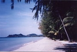
White Sand Beach is one of the island’s longest beaches that attracts a lot of visitors. At the back or the beach are orchards of coconut trees and forests.
Activities
HikingHiking on Ko Chang is popular due to the natural pristine surroundings including waterfalls, especially the routes Klong Son to Kai Bae and Kai Bae to Bang Bao.
Mountain Biking
Mountain bikes are available to rent at Hat Sai Khao and Hat Kaibae.
Elephant Trekking
Elephant Trekking is possible at the Ban Kwan Chang Elephant Camp at Klong Son, it is supported by the Asian Elephant Foundation to provide a natural environment for elephants and their mahouts.
Canoeing
Canoeing through the mangrove forests is most popular.
Diving & Snorkeling
This area does not have deep diving as in the west coast, but some very nice coral dives and a good variation in fish life. There are quite a lot of dive sites. There are several diving schools offering day trips and courses for different levels. For e.g.: Koh Rang national park has sites as Koh Laun, koh tong lang, Hin Kuak Maa, koh yak, koh thain. Then there are sites closer to Koh Chang, such as Hin Luk Bath, Hin Rap South, Hin Run Tek, Hin tai nam.
Spa
Ko Chang has plenty of spas offering various forms of massage, aromatherapy, herbal scrub, and reflexology. Spa service is found at many of the top resorts and hotels.
Local produce
Besides its seafood, Trat province is also renowned for its tropical fruits during the months of April to July, they include: rambutan, durian and pineapples.Located in Nam Chieo district is a cottage industry which produces ‘ngop’ (traditional Thai farming hat).
Nightlife & Drink
Koh Chang nightlife and bar scene is constantly developing, there are a number of nice bars and restaurants to enjoy at. Other than that Ko Chang is not, unlike some of the islands down south, famed for its nightlife.Local Culture
Thai Buddhism is a large part of the people’s lives on Ko Chang and so there are few temples scattered around the island.Lifestyle
Many of the island’s villagers still, until this day, adhere to the traditional Siamese way of life. Visitors are able to soak up the ambience of traditional rural coastal life at a variety of locations.Baan Bang Bao or Bang Bao Fishery Village is unique in that every dwelling was built in the sea. There are small bridges connecting each one. Some of the abodes have been transformed into guesthouses and seafood restaurants.
Baan Khlong Son or Khlong Son Village has rubber plantations, orchards and traditional fishery. For tourists there are fishing tours, squid fishing or snorkeling to view schools of fishes on Koh Mapring and Koh Chang Noi nearby.
Baan Dan Kao or Dan Kao Village has indigenous folk of Koh Chang Noi who rear the fish in floating baskets especially “Yamsawat Fish” or Blue Spotted Sea Bass which are popular among the locals who prefer to eat live fish.
Baan Dan Mai(Dan Mai Village) and Baan Khlong Non Si (Khlong Non Si Village) have orchards, coconut plantations and traditional fishery. The lychee trees grown here are the traditional breed called “Silaman 200 years”. This breed of lychee tree has the large size and it is believed to be found on Koh Chang Noi only.
Baan Salak Petch or Salak Petch villagers mainly work about coastal fishery. Most houses were built in the sea like those in Bang Bao Village but it is a bigger community. Every house is connected with the wood bridge.
Baan Rong Than or Rong Than Village is an area which used to be the sites, owned by most villagers, for charcoal making from mangrove wood.
Baan Jek Bae or Jek Bae villagers work about traditional fishery, rubber plantation and coconut plantation.
Events & Festivals
The Koh Chang Yutthanavi DayThe Ko Chang Yutthanavi Day is organized in late January at the Ko Chang Yutthanavi Memorial on Laem Ngop. The event commemorates the Royal Thai Navy’s fight against the French on January 17, 1941. There is an exhibition by the Royal Thai Navy and merit-making and tribute rites are performed.
Local Food
Similar to the rest of Thailand, including the prices. There are many restaurants at the beach open both daytime and evening. Ko Chang’s restaurants specialize in seafood while offering their customers splendid views. The island also produces its own variety of fruity wines which include: mangosteen, pineapple and grape.Learn
Besides diving, Thai cooking courses on Ko Chang are where wanna-be Thai cuisine chefs can learn to cook up all their favourite dishes such as tom yum kung, sweet green curry and chicken with cashew nuts.Medical Health Care
Ko Chang now has two main medical centers, the Bangkok Koh Chang Hospital and Koh Chang Hospital. There are plenty of clinics also scattered around the island.Retirement
More and more foreigners are living on Ko Chang, many of them retirees. A favourite spot for them are on the beaches. There are some other retirees though, who reside in quieter locations away from the tourist scene.Media/Contact
Nationwide Television, Satellite TV, cable TV and local TV (Koh Chang Television) channels are available on Koh Chang (http://www.kohchangtv.com). International newspapers and magazines are also available in a couple bookstores at White Sand Beach, Lonely beach and Ao Khlong Phrao.Landline telephone, satellite telephone system, mobile phones and internet connection are available on Koh Chang. And, there is a Post Office on the island.