
Transportation in South Dakota
Encyclopedia
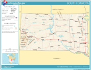
Roads
Montana
Montana is a state in the Western United States. The western third of Montana contains numerous mountain ranges. Smaller, "island ranges" are found in the central third of the state, for a total of 77 named ranges of the Rocky Mountains. This geographical fact is reflected in the state's name,...
are the only states sharing a land border which is not traversed by a paved road.
Interstate highways
Two major interstates pass through South Dakota: Interstate 90Interstate 90 in South Dakota
In the U.S. state of South Dakota, Interstate 90 traverses east–west through the southern half of the state.-Route description:Interstate 90 enters South Dakota in Lawrence County as a four lane divided highway. It enters concurrently with U.S. Route 14, and passes through the town of...
, which runs east and west; and Interstate 29
Interstate 29 in South Dakota
In the U.S. state of South Dakota, Interstate 29 traverses on the eastern side of the state, bypassing through Sioux Falls, the state's largest city.-Route description:...
, running north and south in the eastern portion of the state. Also located in the state are the shorter interstates 190
Interstate 190 (South Dakota)
Interstate 190 is an auxiliary Interstate Highway in the U.S. state of South Dakota. The route runs for about two miles south, connecting I-90 to downtown Rapid City. The entire length overlaps U.S. Route 16. It is the westernmost auxiliary route of Interstate 90, approximately 1150 miles east...
, a spur
Spur route
A spur route is a short road forming a branch from a longer, more important route . A bypass or beltway is never considered a true spur route as it typically reconnects with the major road...
into central Rapid City, and 229
Interstate 229 (South Dakota)
Interstate 229 in South Dakota runs just more than ten miles mostly within the city limits of Sioux Falls, the largest city in the state. It runs from Interstate 29 to Interstate 90...
, a loop
Loop route
A loop route is a highway or other major road that extends out from a typically longer, more important parents road to enter and circle a large city. A loop can function as a bypass for through traffic and also to service outlying suburbs....
around eastern and southern Sioux Falls.
The length of South Dakota's portion of I-29 is 252 miles (405.6 km). Larger cities served by the route include Watertown
Watertown, South Dakota
Watertown is a city in and the county seat of Codington County, South Dakota, United States. The population was 21,482 at the 2010 census. It is also the principal city of the Watertown Micropolitan Statistical Area, which includes all of Codington and Hamlin counties...
, Brookings
Brookings, South Dakota
Brookings is a city in Brookings County, South Dakota, United States. Brookings is the fourth largest city in South Dakota, with a population of 22,056 at the 2010 census. It is the county seat of Brookings County, and home to South Dakota State University, the largest institution of higher...
, Sioux Falls, and Vermillion
Vermillion, South Dakota
Vermillion is a city in and the county seat of Clay County, in the southeastern corner of the U.S. state of South Dakota, and the tenth largest city in the state. According to the 2010 Census, the population was 10,571. Vermillion lies atop a bluff near the Missouri River.The area has been home to...
. The I-29 corridor features generally higher rates of population and economic growth than areas in eastern South Dakota that are further from the interstate.
I-90 runs through the state for a distance of 413 miles (664.7 km), crossing the Missouri River near Chamberlain
Chamberlain, South Dakota
Chamberlain is a city in Brule County, South Dakota, United States. The population was 2,387 at the 2010 census. It is the county seat of Brule County. Chamberlain is home to the Akta Lakota Museum and Cultural Center, which profiles the lives of nomadic Plains Indians...
. Major cities along the route include Sioux Falls, Mitchell
Mitchell, South Dakota
-Demographics:As of the census of 2000, there were 14,558 people, 6,121 households, and 3,599 families residing in the city. The population density was 1,475.7 people per square mile . There were 6,555 housing units at an average density of 664.4 per square mile...
, Rapid City, Sturgis
Sturgis, South Dakota
Sturgis is a city in Meade County, South Dakota, United States. The population was 6,627 as of the 2010 census. It is the county seat of Meade County. Sturgis is famous for being the location of one of the largest annual motorcycle events in the world, which is held annually on the first full week...
and Spearfish
Spearfish, South Dakota
Spearfish is a city in Lawrence County, South Dakota,United States. The population was 10,494 at the 2010 census.- History :Prior to the Black Hills Gold Rush of 1876, the area was used by Native Americans who would spear fish in the creek...
. I-90, being a major route between western national parks and large cities to the east, brings many out-of-state travelers through South Dakota, thus helping to boost the tourism and hospitality industries. A number of tourist attractions are located along the route, including the Corn Palace
Corn Palace
The Corn Palace is a multi-purpose arena/facility located in Mitchell, South Dakota. It is a popular tourist destination, visited by more than 500,000 people each year. The Moorish Revival building is decorated with Crop art; the murals and designs covering the building are made from corn and...
in Mitchell and Wall Drug
Wall Drug
Wall Drug Store, often referred to simply as "Wall Drug", is a tourist attraction located in the town of Wall, South Dakota, United States. It is a shopping mall consisting of a drug store, gift shop, restaurants and various other stores. Unlike a traditional shopping mall, all the stores at Wall...
in Wall
Wall, South Dakota
Wall is a town in Pennington County, South Dakota, United States. The population was 766 at the 2010 census...
.
Other highways
Several major U.S. highways pass through the state. U.S. routes 12U.S. Route 12
U.S. Route 12 or US 12 is an east–west United States highway, running from Grays Harbor on the Pacific Ocean, in the state of Washington, to downtown Detroit, for almost . As a thoroughfare, it has mostly been supplanted by I-90 and I-94, but remains an important road for local travel.The...
, 14
U.S. Route 14
U.S. Route 14 , an east–west route, is one of the original United States highways of 1926. It currently has a length of 1,398 miles , but it had a peak length of 1,429 miles . For much of its length, it runs roughly parallel to Interstate 90.As of 2004, the highway's eastern terminus is in...
, 16
U.S. Route 16
U.S. Route 16 is an east–west United States Highway between Rapid City, South Dakota and Yellowstone National Park in Wyoming....
, 18
U.S. Route 18
U.S. Route 18 is an east–west U.S. highway in the Midwestern United States. The western terminus is in Orin, Wyoming at an interchange with Interstate 25. Its eastern terminus of US 18 is in downtown Milwaukee, Wisconsin. However, US 18 runs concurrent with other U.S...
, and 212
U.S. Route 212
U.S. Route 212 is a spur of U.S. Route 12. Though it currently never intersects U.S. 12, it once had an eastern terminus at U.S. 12 in St. Paul, Minnesota. It runs for 949 miles from Minnesota Highway 62 at Edina, Minnesota to Yellowstone National Park.U.S. 212 passes through the states of...
travel east and west, while U.S. routes 81
U.S. Route 81
U.S. Route 81 is one of the many United States Numbered Highways established in 1926 by the US Department of Agriculture Bureau of Public Roads....
, 83
U.S. Route 83
U.S. Route 83 is one of the longest north–south U.S. Highways in the United States, at . Only four other north–south routes are longer: U.S. Routes 1, 41, 59 and 87. The highway's northern terminus is north of Westhope, North Dakota, at the Canadian border, where it continues as...
, 85
U.S. Route 85
U.S. Route 85 is a north–south United States highway that runs for in the Mountain - Northern Plains states of the United States. The southern terminus of the route is at the United States-Mexico border in El Paso, Texas, connecting with Mexican Federal Highway 45...
and 281
U.S. Route 281
U.S. Route 281 is a north–south United States highway. At 1,872 miles long it is the longest continuous three-digit U.S. Route....
run north and south.
South Dakota Highway 100 is a planned limited access road in Sioux Falls. Originally known as the Eastern Corridor, the highway will wrap around the eastern and southern sections of the city, running from Exit 402 on Interstate 90 in the north and intersecting with Interstate 29 near Tea
Tea, South Dakota
Tea is a city in Lincoln County, South Dakota, United States and is a suburb of Sioux Falls. The population was 3,806 at the 2010 census.-Geography:Tea is located at ....
. Planning for the 17 miles (27.4 km) route began in 1995.
Scenic byways
South Dakota contains two National Scenic BywayNational Scenic Byway
A National Scenic Byway is a road recognized by the United States Department of Transportation for its archeological, cultural, historic, natural, recreational, and/or scenic qualities. The program was established by Congress in 1991 to preserve and protect the nation's scenic but often...
s. The Peter Norbeck National Scenic Byway
Peter Norbeck Scenic Byway
The Peter Norbeck Scenic Byway is a National Scenic Byway in the Black Hills National Forest in South Dakota, USA. It is a loop which is composed of portions of U.S. Route 16A, South Dakota Highway 244, South Dakota Highway 87, and South Dakota Highway 89. Parts of the byway enter Black Hills...
is located in the Black Hills, while the Native American Scenic Byway runs along the Missouri River in the north-central part of the state. Other scenic byways include the Badlands Loop Scenic Byway, the Spearfish Canyon Scenic Byway, and the Wildlife Loop Road Scenic Byway.
Railroads
Railroads have played an important role in South Dakota transportation since the mid-19th century. Historically, the Milwaukee Road and the Chicago & North WesternChicago and North Western Railway
The Chicago and North Western Transportation Company was a Class I railroad in the Midwest United States. It was also known as the North Western. The railroad operated more than of track as of the turn of the 20th century, and over of track in seven states before retrenchment in the late 1970s...
were the state's largest railroads, and the Milwaukee's east-west transcontinental line traversed the northern tier of the state. Some 4420 miles (7,113.3 km) of railroad track were built in South Dakota during the late nineteenth and early twentieth centuries, but only 1839 miles (2,959.6 km) are active. BNSF Railway
BNSF Railway
The BNSF Railway is a wholly owned subsidiary of Berkshire Hathaway Inc., and is headquartered in Fort Worth, Texas. It is one of seven North American Class I railroads and the second largest freight railroad network in North America, second only to the Union Pacific Railroad, its primary...
is currently the largest railroad in South Dakota, primarily operating former Milwaukee Road trackage; the Dakota, Minnesota, and Eastern Railroad is the state's other major carrier, mostly operating former Chicago & North Western trackage. Rail transportation in the state is confined only to freight, however, as South Dakota is one of the few states without any Amtrak
Amtrak
The National Railroad Passenger Corporation, doing business as Amtrak , is a government-owned corporation that was organized on May 1, 1971, to provide intercity passenger train service in the United States. "Amtrak" is a portmanteau of the words "America" and "track". It is headquartered at Union...
service.
Air
South Dakota's largest commercial airports in terms of passenger traffic are the Sioux Falls Regional AirportSioux Falls Regional Airport
Sioux Falls Regional Airport , also known as Joe Foss Field, is a joint civil and military use airport located three nautical miles northwest of the central business district of Sioux Falls, a city in Minnehaha County, South Dakota, United States...
and Rapid City Regional Airport
Rapid City Regional Airport
Rapid City Regional Airport is a city-owned, public-use airport located eight nautical miles southeast of the central business district of Rapid City, in Pennington County, South Dakota, United States.- Facilities and aircraft :...
. Northwest Airlines, Frontier Airlines, and Allegiant Airlines, as well as commuter airlines using the brand affiliation with major airlines serve the two largest airports. Several other cities in the state also have commercial air service, some of which is subsidized by the Essential Air Service
Essential Air Service
Essential Air Service is a U.S. government program enacted to guarantee that small communities in the United States, which, prior to deregulation, were served by certificated airlines, maintained commercial service. Its aim is to maintain a minimal level of scheduled air service to these...
program.
Laws and licenses
The speed limitSpeed limit
Road speed limits are used in most countries to regulate the speed of road vehicles. Speed limits may define maximum , minimum or no speed limit and are normally indicated using a traffic sign...
in South Dakota is 75 miles per hour (121 km/h) on rural interstates, regardless of vehicle type and time of day, and 65 mph (105 km/h) on urban interstates and other highways.
South Dakota license plates are numbered with the first digit referring to the county of origin. Counties 1–9 are ranked by 1950 population, and counties 10–64 are numbered alphabetically.
Studded tires are permitted to be used from October 1 to April 30, except on school buses and fire vehicles which are permitted year round.