

U.S. Route 212
Encyclopedia
U.S. Route 212 is a spur of U.S. Route 12
. Though it currently never intersects U.S. 12, it once had an eastern terminus at U.S. 12 in St. Paul, Minnesota. It runs for 949 miles (1,527 km) from Minnesota Highway 62
at Edina, Minnesota
to Yellowstone National Park
.
U.S. 212 passes through the states of Minnesota
, South Dakota
, Wyoming
, and Montana
. It goes through the cities of Watertown, South Dakota
and Billings, Montana
.
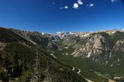
 The western terminus of Highway 212 is at the Montana/Wyoming state line within Yellowstone National Park. Within the park it is contiguous with Northeast Entrance Road, which has its western terminus on the Grand Loop within the Wyoming portion of the park. Highway 212 passes through Cooke City, Montana, then crosses the Wyoming state line and re-emerges into Montana approximately 38 miles (61 km) later. The section of Highway 212 between Cooke City, Montana
and Red Lodge, Montana
is known as the Beartooth Highway
. Rising to an elevation of 10974 feet (3,345 m) above sea level at Beartooth Pass, the highway traces the historical route of Civil War
General Philip Sheridan
over the Beartooth Mountains
. In his book Dateline America published in 1979, the late CBS
correspondent Charles Kuralt
referred to the highway as "the most beautiful drive in America."
 Running northeast from the Beartooth Mountains, Highway 212 joins U.S. Route 310
before passing into the town of Laurel, Montana
. Here Highways 212 joins Interstate 90
eastbound, while Highway 310 ends. Together, Highway 212 and I-90 run east to the city of Billings, Montana
between mile markers 434 and 510, a distance of 76 miles (122 km).
Within the Crow Indian Reservation
, Highway 212 leaves I-90 and runs east and southeast through the high plains of Montana. It is the main east–west road through the Northern Cheyenne Indian Reservation
. Southeast of Alzada, Montana
, Highway 212 recrosses the Wyoming state line; after about 20.3 miles (32.7 km), Highway 212 enters South Dakota
. For the entire length of Highway 212 in Montana between I-90 and the Wyoming state line, it is also known as the Warrior Trail Highway.
. Here is intersects with U.S Route 85, and then continues eastward, skirting the southern end of the Belle Fourche National Wildlife Refuge.
It continues east, passing the town of Nisland
, until connecting with SD-73 south of Newell
. It runs north into Newell, then turns generally east again, passing through the town of Faith
and entering the Cheyenne River Indian Reservation
. It then passes through Dupree
and North Eagle Butte
, finally crossing the Missouri River.
Continuing east, it then intersects U.S. Route 83 near Gettysburg
, where it is co-signed with US-85 briefly, and then continues eastward, passing through Gettysburg and Faulkton
. It intersects with SD-45, where it is cosigned for a brief southern leg, before turning eastward again and passing through Rockham
, Zell
and Redfield
, where it intersects with U.S. Route 281.
Continuing east, it passes through Clark
, before entering Watertown
, becoming 9th Avenue SW. Just east of Watertown, it intersects with Interstate 29
, and continues east to the Minnesota state line.
 Legally, the South Dakota section of U.S. 212 is defined at South Dakota Codified Laws § 31-4-206.http://legis.state.sd.us/statutes/DisplayStatute.aspx?Type=Statute&Statute=31-4-206
Legally, the Minnesota section of U.S. 212 is defined as Routes 155, 12, 187, and 260 in Minnesota Statutes §§ 161.114(2) and 161.115(86), (118), and (191).http://ros.leg.mn/bin/getpub.php?pubtype=STAT_CHAP&year=2006§ion=161#stat.161.114.0http://ros.leg.mn/bin/getpub.php?pubtype=STAT_CHAP&year=2006§ion=161#stat.161.115.0
U.S. Route 12
U.S. Route 12 or US 12 is an east–west United States highway, running from Grays Harbor on the Pacific Ocean, in the state of Washington, to downtown Detroit, for almost . As a thoroughfare, it has mostly been supplanted by I-90 and I-94, but remains an important road for local travel.The...
. Though it currently never intersects U.S. 12, it once had an eastern terminus at U.S. 12 in St. Paul, Minnesota. It runs for 949 miles (1,527 km) from Minnesota Highway 62
Minnesota State Highway 62 (east)
Minnesota State Highway 62 is a highway in the Twin Cities region of Minnesota. The route was part of Hennepin County Road 62 until 1988, when a portion of the route was inherited by the state. The western terminus of the route is at Interstate Highway 494 in Eden Prairie, where the roadway...
at Edina, Minnesota
Edina, Minnesota
Edina is a city in Hennepin County, Minnesota, United States, and a first-ring suburb situated immediately southwest of Minneapolis. Edina began as a small farming and milling community in the 1860s. The population was 47,941 at the 2010 census.-Geography:...
to Yellowstone National Park
Yellowstone National Park
Yellowstone National Park, established by the U.S. Congress and signed into law by President Ulysses S. Grant on March 1, 1872, is a national park located primarily in the U.S. state of Wyoming, although it also extends into Montana and Idaho...
.
U.S. 212 passes through the states of Minnesota
Minnesota
Minnesota is a U.S. state located in the Midwestern United States. The twelfth largest state of the U.S., it is the twenty-first most populous, with 5.3 million residents. Minnesota was carved out of the eastern half of the Minnesota Territory and admitted to the Union as the thirty-second state...
, South Dakota
South Dakota
South Dakota is a state located in the Midwestern region of the United States. It is named after the Lakota and Dakota Sioux American Indian tribes. Once a part of Dakota Territory, South Dakota became a state on November 2, 1889. The state has an area of and an estimated population of just over...
, Wyoming
Wyoming
Wyoming is a state in the mountain region of the Western United States. The western two thirds of the state is covered mostly with the mountain ranges and rangelands in the foothills of the Eastern Rocky Mountains, while the eastern third of the state is high elevation prairie known as the High...
, and Montana
Montana
Montana is a state in the Western United States. The western third of Montana contains numerous mountain ranges. Smaller, "island ranges" are found in the central third of the state, for a total of 77 named ranges of the Rocky Mountains. This geographical fact is reflected in the state's name,...
. It goes through the cities of Watertown, South Dakota
Watertown, South Dakota
Watertown is a city in and the county seat of Codington County, South Dakota, United States. The population was 21,482 at the 2010 census. It is also the principal city of the Watertown Micropolitan Statistical Area, which includes all of Codington and Hamlin counties...
and Billings, Montana
Billings, Montana
Billings is the largest city in the U.S. state of Montana, and is the principal city of the Billings Metropolitan Area, the largest metropolitan area in over...
.
Montana / Wyoming
Cooke City-Silver Gate, Montana
Cooke City-Silver Gate is a census-designated place in Park County, Montana, United States. The population was 140 at the 2000 census.-Geography:Cooke City-Silver Gate is located at ....
and Red Lodge, Montana
Red Lodge, Montana
Red Lodge is a city in and the county seat of Carbon County, Montana, United States. It is part of the Billings, Montana Metropolitan Statistical Area...
is known as the Beartooth Highway
Beartooth Highway
The Beartooth Highway is an All-American Road that has been called "the most beautiful drive in America," by late CBS correspondent Charles Kuralt...
. Rising to an elevation of 10974 feet (3,345 m) above sea level at Beartooth Pass, the highway traces the historical route of Civil War
American Civil War
The American Civil War was a civil war fought in the United States of America. In response to the election of Abraham Lincoln as President of the United States, 11 southern slave states declared their secession from the United States and formed the Confederate States of America ; the other 25...
General Philip Sheridan
Philip Sheridan
Philip Henry Sheridan was a career United States Army officer and a Union general in the American Civil War. His career was noted for his rapid rise to major general and his close association with Lt. Gen. Ulysses S...
over the Beartooth Mountains
Beartooth Mountains
The Beartooth Mountains are located in south central Montana and northwest Wyoming, U.S. and are part of the 900,000 acre Absaroka-Beartooth Wilderness, within Custer, Gallatin and Shoshone National Forests. The Beartooths are the location of Granite Peak, which at 12,807 feet is the highest...
. In his book Dateline America published in 1979, the late CBS
CBS
CBS Broadcasting Inc. is a major US commercial broadcasting television network, which started as a radio network. The name is derived from the initials of the network's former name, Columbia Broadcasting System. The network is sometimes referred to as the "Eye Network" in reference to the shape of...
correspondent Charles Kuralt
Charles Kuralt
Charles Kuralt was an American journalist. He was most widely known for his long career with CBS, first for his "On the Road" segments on The CBS Evening News with Walter Cronkite, and later as the first anchor of CBS News Sunday Morning, a position he held for fifteen years.Kuralt's "On the Road"...
referred to the highway as "the most beautiful drive in America."
U.S. Route 310
U.S. Route 310 is a spur of U.S. Route 10. It runs for from Laurel, Montana to Greybull, Wyoming. It passes through the states of Montana and Wyoming. Near the town of Lovell, Wyoming, US 310 is concurrent with U.S. Route 14A for approximately three miles....
before passing into the town of Laurel, Montana
Laurel, Montana
Laurel is a city in Yellowstone County, Montana, United States. It is part of the Billings, Montana Metropolitan Statistical Area, and is located in the Yellowstone Valley, as an east-west terminal division point of the Burlington-Northern Railroad.. The population was 6,781 at the 2010 census.Both...
. Here Highways 212 joins Interstate 90
Interstate 90 in Montana
Interstate 90 in Montana is a portion of the east–west transcontinental Interstate 90, which links Seattle, Washington to Boston, Massachusetts. The portion in the U.S...
eastbound, while Highway 310 ends. Together, Highway 212 and I-90 run east to the city of Billings, Montana
Billings, Montana
Billings is the largest city in the U.S. state of Montana, and is the principal city of the Billings Metropolitan Area, the largest metropolitan area in over...
between mile markers 434 and 510, a distance of 76 miles (122 km).
Within the Crow Indian Reservation
Crow Nation
The Crow, also called the Absaroka or Apsáalooke, are a Siouan people of Native Americans who historically lived in the Yellowstone River valley, which extends from present-day Wyoming, through Montana and into North Dakota. They now live on a reservation south of Billings, Montana and in several...
, Highway 212 leaves I-90 and runs east and southeast through the high plains of Montana. It is the main east–west road through the Northern Cheyenne Indian Reservation
Northern Cheyenne Indian Reservation
The Northern Cheyenne Indian Reservation, formerly named the Tongue River Indian Reservation, is an Indian reservation that is home to the Northern Cheyenne tribe of the Native Americans. It is located around the small towns of Lame Deer and Ashland, Montana, in parts of Rosebud and Big Horn...
. Southeast of Alzada, Montana
Alzada, Montana
Alzada is an unincorporated community in Carter County in the southeastern corner of the U.S. state of Montana. It is located at the intersection of U.S. Route 212 with Montana Secondary Highways 323 and 326, near the Wyoming and South Dakota borders...
, Highway 212 recrosses the Wyoming state line; after about 20.3 miles (32.7 km), Highway 212 enters South Dakota
South Dakota
South Dakota is a state located in the Midwestern region of the United States. It is named after the Lakota and Dakota Sioux American Indian tribes. Once a part of Dakota Territory, South Dakota became a state on November 2, 1889. The state has an area of and an estimated population of just over...
. For the entire length of Highway 212 in Montana between I-90 and the Wyoming state line, it is also known as the Warrior Trail Highway.
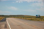
South Dakota
Highway 212 enters South Dakota near the juncture of the Montana, Wyoming and South Dakota state lines, and continues southeast to Belle FourcheBelle Fourche, South Dakota
According to the United States Census Bureau, the city has a total area of , of which are land and is water.-Demographics:As of the census of 2000, there were 4,565 people, 1,854 households, and 1,186 families residing in the city. The population density was 1,446.9 people per square mile...
. Here is intersects with U.S Route 85, and then continues eastward, skirting the southern end of the Belle Fourche National Wildlife Refuge.
It continues east, passing the town of Nisland
Nisland, South Dakota
Nisland is a town in Butte County, South Dakota, United States. The population was 232 at the 2010 census.-Geography:Nisland is located at ....
, until connecting with SD-73 south of Newell
Newell, South Dakota
Newell is a city in Butte County, South Dakota, United States. The population was 603 at the 2010 census.-Geography:Newell is located at .According to the United States Census Bureau, the city has a total area of , all of it land....
. It runs north into Newell, then turns generally east again, passing through the town of Faith
Faith, South Dakota
Faith is a city in Meade County, South Dakota, United States. The population was 421 at the 2010 census. Sue, the most complete Tyrannosaurus rex skeleton known, was discovered about 15 miles north and east of Faith in December 1990.-Geography:...
and entering the Cheyenne River Indian Reservation
Cheyenne River Indian Reservation
The Cheyenne River Indian Reservation was created by the United States in 1889 by breaking up the Great Sioux Reservation, following its victory over the Lakota in a series of wars in the 1870s. The reservation covers almost all of Dewey and Ziebach counties in South Dakota...
. It then passes through Dupree
Dupree, South Dakota
Dupree is a city in Ziebach County, South Dakota, United States. The population was 525 at the 2010 census. It is the county seat of Ziebach County.-Geography:Dupree is located at ....
and North Eagle Butte
North Eagle Butte, South Dakota
North Eagle Butte is a census-designated place in Dewey County, South Dakota, United States, along the 45th parallel. The population was 1,954 at the 2010 census.-Geography:North Eagle Butte is located at ....
, finally crossing the Missouri River.
Continuing east, it then intersects U.S. Route 83 near Gettysburg
Gettysburg, South Dakota
Gettysburg is a city in Potter County, South Dakota, United States, along the 45th parallel. The population was 1,162 at the 2010 census. It is the county seat of Potter County. Gettysburg area historical tornado activity is 42 percent less than the overall U.S...
, where it is co-signed with US-85 briefly, and then continues eastward, passing through Gettysburg and Faulkton
Faulkton, South Dakota
Faulkton is a city in and the county seat of Faulk County, South Dakota, United States. Its nickname is the Carousel City. The population was 736 at the 2010 census.-Geography:Faulkton is located at ....
. It intersects with SD-45, where it is cosigned for a brief southern leg, before turning eastward again and passing through Rockham
Rockham, South Dakota
Rockham is a town in Faulk County, South Dakota, United States. The population was 33 at the 2010 census.-Geography:Rockham is located at .According to the United States Census Bureau, the town has a total area of , all of it land....
, Zell
Zell, South Dakota
Zell is an unincorporated community in Faulk County, South Dakota, United States, near Rockham.Current Population hovers around fifty.To the east is Redfield, to the west is Rockham, to the north is Aberdeen....
and Redfield
Redfield, South Dakota
Redfield is a city in and the county seat of Spink County, South Dakota, United States. The population was 2,333 at the 2010 census. The city is not to be confused with the surrounding Redfield Township, which encompasses unincorporated areas outside of the city limits.-Geography:Redfield is...
, where it intersects with U.S. Route 281.
Continuing east, it passes through Clark
Clark, South Dakota
Clark is a city in Clark County, South Dakota, United States. The population was 1,139 at the 2010 census. It is the county seat of Clark County.-Geography:Clark is located at ....
, before entering Watertown
Watertown, South Dakota
Watertown is a city in and the county seat of Codington County, South Dakota, United States. The population was 21,482 at the 2010 census. It is also the principal city of the Watertown Micropolitan Statistical Area, which includes all of Codington and Hamlin counties...
, becoming 9th Avenue SW. Just east of Watertown, it intersects with Interstate 29
Interstate 29
Interstate 29 is an Interstate Highway in the Midwestern United States. I-29 runs from Kansas City, Missouri, at a junction with Interstate 35 and Interstate 70 to the Canadian border near Pembina, North Dakota, where it connects with Manitoba Highway 75 via the short Manitoba Highway 29.-Route...
, and continues east to the Minnesota state line.
Minnesota
The 160 miles (257.5 km) of Highway 212 in Minnesota are officially designated Minnesota Veterans Memorial Highway. Yellowstone Trail is the original name designation for this same stretch of U.S. 212 from the auto trail days. Yellowstone Trail was one of the first designated names written into law in the state, but not now marked anywhere along the Minnesota portion of U.S. 212.Legally, the Minnesota section of U.S. 212 is defined as Routes 155, 12, 187, and 260 in Minnesota Statutes §§ 161.114(2) and 161.115(86), (118), and (191).http://ros.leg.mn/bin/getpub.php?pubtype=STAT_CHAP&year=2006§ion=161#stat.161.114.0http://ros.leg.mn/bin/getpub.php?pubtype=STAT_CHAP&year=2006§ion=161#stat.161.115.0