
Totness Recreation Park
Encyclopedia
Totness Recreation Park, is a public park near the town of Totness
, South Australia
in the central Mount Lofty Ranges
. Covering 41 hectares (101 acre) of land, the park is divided by the South Eastern Freeway
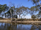
and features a large dam
. It was declared as a reserve in 1970 and re-designated as a recreation park in 1972. The park has no visitor facilities except for access tracks. It is the only park in the district, managed by the Department for Environment and Heritage, that is solely designated for recreation.
While parts of the park are dominated by pest plant species, primarily Gorse
and Blackberry
, it has native plant communities that are of conservation significance. Messmate Stringybark
and Manna Gum woodlands are of particular note, being now uncommon in much of their former range across the Mount Lofty Ranges.
and 2.5 km (1.6 mi) from Mount Barker
. The park covers 41 hectares (101 acre) but is divided by the South Eastern Freeway
, with 9 ha (22 acre) north of the freeway and 32 ha (79 acre) on its south. The only connection between the two sections is a 1.5 metres (5 ft) high, 100 m (328 ft) long, concrete storm water pipe that passes under the freeway. 5.8 ha (14 acre) of the park's southern section is leased for grazing, and fenced off from public access. The park is surrounded by rural properties that are primarily used for grazing. The most prominent feature is a former railway dam in the northern section. Most of the park, and some adjacent rural properties, drain into this dam. Overflow from the dam eventually reaches the Mount Barker Creek and subsequently the Bremer River. There are walking trails throughout the park and dirt vehicle access tracks along the boundaries. A boardwalk, constructed in 2001 in the northern section adjacent to the freeway, enables passage through boggy areas. Apart from the boardwalk there are no built structures and no facilities nor interpretive signs.
The park occupies hill slopes on the eastern side of a ridgeline. The ridge runs from the Bull Creek Range, diving the catchments of the Onkaparinga
and Bremer rivers. Quartzite
and Sandstone
rocks feature in the park's geological formations. The well drained podsol
ic soils of the park are strongly leached and infertile. Soils on the slopes have low water holding capacity and are poor for root development. Soils in the bases of gullies can be deep, and wetter areas become boggy in winter.
Aboriginal Tribe though no cultural artefacts have been found and aboriginal heritage on the site has not been formally investigated. It is managed by the Department for Environment and Heritage (DEH) in association with the Friends of Totness volunteer group. Totness Recreation Park forms part of Yurrebilla; the Greater Mounty Lofty Parklands. Within the Mount Barker District
, it is the only DEH reserve that is dedicated for public recreation. Most of the park is a "Conservation Zone" with no bicycles, swimming, camping, motor vehicles, horse riding or dogs allowed; though dogs on leads are allowed in the northern section and it is recognised that the rules on swimming, dogs and horse riding are not honoured. As with the rest of Adelaide the area has a Mediterranean climate
, with cool wet winters and warm to hot and dry summers. Average annual rainfall is 780 millimetres (31 in), mostly falling from May to August.
The park was registered on the Register of the National Estate in October 1980, based on the park's population of Candlebark Gum (Eucalyptus rubida
) and Eastern Wallaroos (Macropus robustus).
for the large dam in the northern section. This dam was constructed in 1884 and used by the South Australian Railways
to refill steam locomotives. Until 1944 water was piped 5 mi (8 km) to the Mount Barker Railway Station
, mainly for use on trains travelling to Victor Harbour
. The dam also served as a water source for the township of Mount Barker, until replaced by water from the River Murray via the Adelaide-Mannum pipeline in 1955.
The southern section of the park was originally granted to John Dunne in 1853, a significant figure in Mt Barker's early history. The area around the dam was leased by the District Council of Mount Barker for wood and bark harvesting. The bark of the Golden Wattle (Acacia pycnantha) was taken for use in the Mount Barker tannery and Messmate Stringybark (Eucalyptus obliqua
) trees were cut for firewood. Until 1970 the park's land belonged to the South Australian Railways and the state government Department of Transport. It was transferred to the then National Parks Commission in 1970 and dedicated as a reserve. In 1972 it was constituted as a recreation park, under the new National Parks and Wildlife Act, to protect natural habitat and provide recreational opportunities. The section south of the freeway was completely burnt out by the 1983 Ash Wednesday
bushfires. The fire was stopped by the dividing road and the two sections now show different growth patterns with mallee
or coppiced
regrowth in the south and mature woodland in the north.
, Dog Rose
and blackberry
and the south was regrowing from timber cutting. Gorse was dominant enough that the park had been referred to as 'Gorse Park'. Introduced plants were a major issue and still dominate some areas. Park management, to 2007, has been largely directed at controlling Gorse. Undergrowth is slashed each year to manage the fuel load for bushfires.
Over 180 native plant species and 46 weed species have been identified. Gorse, Blackberry and Bridal Creeper are listed as Weeds of National Significance; they are seen as South Australia's most environmentally threatening weeds. Blackberry, Dog Rose and African Daisy are mainly confined to drainage lines and areas near the Dam. Montpellier Broom (Genista monspessulana) is another prominent weed in the park. Phalaris
dominates much of the leased area. In the early 21st century two new weed species were found: Pussy-tails (Pentaschistis thunbergia) and African Orchids (Disa bracteata
). Cinnamon fungus (Phytophtora cinnamomi) is a significant pathogen, damaging plant species throughout the Adelaide hills. It has not been found yet in the park, but is suspected as being present in the southern section. The park has native plant communities that are of conservation significance due to their rarity in the contemporary Adelaide Hills including Messmate Stringybark (Eucalyptus obliqua
) woodland and open forest, and Manna Gum (Eucalyptus viminalis) woodland.
s and occasional Australian Pelican
s have been sighted. In 1980 some Big-headed gudgeons (Philypnodon grandiceps), a small native fish, were released into the dam, presumably as food source for the introduced Redfin Perch (Perca fluviatilis) which are kept for recreational fishing.
Small numbers of Western Grey Kangaroo (Macropus fuliginosus) shelter in the park during the day and feed in neighbouring pastures. Common Ringtail Possums (Pseudocheirus peregrinus), Short-beaked Echidna (Tachyglossus aculeatus) and various bat species are known to inhabit the park. Koala
s are found in the park, though they are not native to the Mount Lofty Ranges. Introduced and feral animal species are commonly sighted including: European Rabbits (Oryctolagus cuniculus), Brown Hares (Lepus capensis), House Mice (Mus musculus), Black Rats (Rattus rattus), Red Foxes (Vulpes vulpes) and deer (Dama dama). Cats and Dogs (probably domestic strays) have been recorded as well as numerous introduced bird species. As of 2006 rabbits are the most significant pest species in the park; destroying soil structure and impeding the regeneration of native plants.
Totness, South Australia
Totness is a recent addition to South Australia, and consists mainly of industrial zoned areas. It is commonly referred to as Mount Barker or Littlehampton but is actually a town of its own...
, South Australia
South Australia
South Australia is a state of Australia in the southern central part of the country. It covers some of the most arid parts of the continent; with a total land area of , it is the fourth largest of Australia's six states and two territories.South Australia shares borders with all of the mainland...
in the central Mount Lofty Ranges
Mount Lofty Ranges
The Mount Lofty Ranges are the range of mountains just to the east of Adelaide in South Australia.-Location and description:The Mount Lofty Ranges stretch from the southernmost point of the Fleurieu Peninsula at Cape Jervis northwards for over before petering out north of Peterborough...
. Covering 41 hectares (101 acre) of land, the park is divided by the South Eastern Freeway
South Eastern Freeway
The South Eastern Freeway is a 66 kilometre four-lane divided carriageway road in South Australia linking the Adelaide-Crafers Highway to the Princes Highway at the Swanport Bridge, a one kilometre long bridge over the River Murray, near Murray Bridge...
and features a large dam
Dam
A dam is a barrier that impounds water or underground streams. Dams generally serve the primary purpose of retaining water, while other structures such as floodgates or levees are used to manage or prevent water flow into specific land regions. Hydropower and pumped-storage hydroelectricity are...
. It was declared as a reserve in 1970 and re-designated as a recreation park in 1972. The park has no visitor facilities except for access tracks. It is the only park in the district, managed by the Department for Environment and Heritage, that is solely designated for recreation.
While parts of the park are dominated by pest plant species, primarily Gorse
Gorse
Gorse, furze, furse or whin is a genus of about 20 plant species of thorny evergreen shrubs in the subfamily Faboideae of the pea family Fabaceae, native to western Europe and northwest Africa, with the majority of species in Iberia.Gorse is closely related to the brooms, and like them, has green...
and Blackberry
Blackberry
The blackberry is an edible fruit produced by any of several species in the Rubus genus of the Rosaceae family. The fruit is not a true berry; botanically it is termed an aggregate fruit, composed of small drupelets. The plants typically have biennial canes and perennial roots. Blackberries and...
, it has native plant communities that are of conservation significance. Messmate Stringybark
Eucalyptus obliqua
Eucalyptus obliqua, commonly known as Australian Oak, Brown Top, Brown Top Stringbark, Messmate, Messmate Stringybark, Stringybark and Tasmanian Oak, is a hardwood tree native to south-eastern Australia....
and Manna Gum woodlands are of particular note, being now uncommon in much of their former range across the Mount Lofty Ranges.
Structure
Totness Recreation Park is approximately 25 kilometres (16 mi) from AdelaideAdelaide
Adelaide is the capital city of South Australia and the fifth-largest city in Australia. Adelaide has an estimated population of more than 1.2 million...
and 2.5 km (1.6 mi) from Mount Barker
Mount Barker, South Australia
Mount Barker is an expanding city, home to 10 258 residents that is 33 kilometres up the South Eastern Freeway, east of Adelaide, in South Australia. It is the seat of the District Council of Mount Barker, is the largest town in the Adelaide Hills, and is one of the fastest growing areas in the...
. The park covers 41 hectares (101 acre) but is divided by the South Eastern Freeway
South Eastern Freeway
The South Eastern Freeway is a 66 kilometre four-lane divided carriageway road in South Australia linking the Adelaide-Crafers Highway to the Princes Highway at the Swanport Bridge, a one kilometre long bridge over the River Murray, near Murray Bridge...
, with 9 ha (22 acre) north of the freeway and 32 ha (79 acre) on its south. The only connection between the two sections is a 1.5 metres (5 ft) high, 100 m (328 ft) long, concrete storm water pipe that passes under the freeway. 5.8 ha (14 acre) of the park's southern section is leased for grazing, and fenced off from public access. The park is surrounded by rural properties that are primarily used for grazing. The most prominent feature is a former railway dam in the northern section. Most of the park, and some adjacent rural properties, drain into this dam. Overflow from the dam eventually reaches the Mount Barker Creek and subsequently the Bremer River. There are walking trails throughout the park and dirt vehicle access tracks along the boundaries. A boardwalk, constructed in 2001 in the northern section adjacent to the freeway, enables passage through boggy areas. Apart from the boardwalk there are no built structures and no facilities nor interpretive signs.
The park occupies hill slopes on the eastern side of a ridgeline. The ridge runs from the Bull Creek Range, diving the catchments of the Onkaparinga
Onkaparinga River
The Onkaparinga River runs from its source between Mount Torrens and Charleston in the Mount Lofty Ranges, and flows south westerly to an estuary at Port Noarlunga. The catchment is over 500 km² in area, and is in part located in the Onkaparinga River National Park.The Onkaparinga River is the...
and Bremer rivers. Quartzite
Quartzite
Quartzite is a hard metamorphic rock which was originally sandstone. Sandstone is converted into quartzite through heating and pressure usually related to tectonic compression within orogenic belts. Pure quartzite is usually white to gray, though quartzites often occur in various shades of pink...
and Sandstone
Sandstone
Sandstone is a sedimentary rock composed mainly of sand-sized minerals or rock grains.Most sandstone is composed of quartz and/or feldspar because these are the most common minerals in the Earth's crust. Like sand, sandstone may be any colour, but the most common colours are tan, brown, yellow,...
rocks feature in the park's geological formations. The well drained podsol
Podsol
In soil science, podzols are the typical soils of coniferous, or boreal forests. They are also the typical soils of eucalypt forests and heathlands in southern Australia...
ic soils of the park are strongly leached and infertile. Soils on the slopes have low water holding capacity and are poor for root development. Soils in the bases of gullies can be deep, and wetter areas become boggy in winter.
Management and access
The park is part of the traditional lands of the PeramangkPeramangk
The Peramangk are an Indigenous Australian people whose traditional lands are primarily located in the Adelaide Hills, but also in the southern stretches of the Fleurieu Peninsula, South Australia...
Aboriginal Tribe though no cultural artefacts have been found and aboriginal heritage on the site has not been formally investigated. It is managed by the Department for Environment and Heritage (DEH) in association with the Friends of Totness volunteer group. Totness Recreation Park forms part of Yurrebilla; the Greater Mounty Lofty Parklands. Within the Mount Barker District
District Council of Mount Barker
The District Council of Mount Barker is a Local Government Area centred on the town of Mount Barker just outside of the Adelaide metropolitan area in South Australia.- Towns and localities :...
, it is the only DEH reserve that is dedicated for public recreation. Most of the park is a "Conservation Zone" with no bicycles, swimming, camping, motor vehicles, horse riding or dogs allowed; though dogs on leads are allowed in the northern section and it is recognised that the rules on swimming, dogs and horse riding are not honoured. As with the rest of Adelaide the area has a Mediterranean climate
Mediterranean climate
A Mediterranean climate is the climate typical of most of the lands in the Mediterranean Basin, and is a particular variety of subtropical climate...
, with cool wet winters and warm to hot and dry summers. Average annual rainfall is 780 millimetres (31 in), mostly falling from May to August.
The park was registered on the Register of the National Estate in October 1980, based on the park's population of Candlebark Gum (Eucalyptus rubida
Eucalyptus rubida
The Candlebark is a medium sized tree of the genus Eucalyptus. It occurs in south eastern Australia and Tasmania, typically in open woodland around the lower slopes of the Great Dividing Range, but also in taller forests...
) and Eastern Wallaroos (Macropus robustus).
History
Most of the park forms a watershedDrainage basin
A drainage basin is an extent or an area of land where surface water from rain and melting snow or ice converges to a single point, usually the exit of the basin, where the waters join another waterbody, such as a river, lake, reservoir, estuary, wetland, sea, or ocean...
for the large dam in the northern section. This dam was constructed in 1884 and used by the South Australian Railways
South Australian Railways
South Australian Railways built and operated railways in South Australia from 1854 to the incorporation of its non-urban railways into the Australian National Railways Commission in 1975, together with the former Commonwealth Railways and the former Tasmanian Government Railways...
to refill steam locomotives. Until 1944 water was piped 5 mi (8 km) to the Mount Barker Railway Station
Mount Barker railway station, South Australia
Mount Barker railway station is a preserved railway station in South Australia on the Victor Harbor railway line, formerly operated by South Australian Railways and it successor, Australian National. With only broad gauge track running through the station, it has been disconnected from the Adelaide...
, mainly for use on trains travelling to Victor Harbour
Victor Harbor, South Australia
Victor Harbor is a city located on the coast of the Fleurieu Peninsula, about 80 km south of Adelaide, South Australia. The city is the largest population centre on the peninsula, with an economy based upon agriculture, fisheries and various industries...
. The dam also served as a water source for the township of Mount Barker, until replaced by water from the River Murray via the Adelaide-Mannum pipeline in 1955.
The southern section of the park was originally granted to John Dunne in 1853, a significant figure in Mt Barker's early history. The area around the dam was leased by the District Council of Mount Barker for wood and bark harvesting. The bark of the Golden Wattle (Acacia pycnantha) was taken for use in the Mount Barker tannery and Messmate Stringybark (Eucalyptus obliqua
Eucalyptus obliqua
Eucalyptus obliqua, commonly known as Australian Oak, Brown Top, Brown Top Stringbark, Messmate, Messmate Stringybark, Stringybark and Tasmanian Oak, is a hardwood tree native to south-eastern Australia....
) trees were cut for firewood. Until 1970 the park's land belonged to the South Australian Railways and the state government Department of Transport. It was transferred to the then National Parks Commission in 1970 and dedicated as a reserve. In 1972 it was constituted as a recreation park, under the new National Parks and Wildlife Act, to protect natural habitat and provide recreational opportunities. The section south of the freeway was completely burnt out by the 1983 Ash Wednesday
Ash Wednesday
Ash Wednesday, in the calendar of Western Christianity, is the first day of Lent and occurs 46 days before Easter. It is a moveable fast, falling on a different date each year because it is dependent on the date of Easter...
bushfires. The fire was stopped by the dividing road and the two sections now show different growth patterns with mallee
Mallee (habit)
Mallee is the growth habit of certain eucalypt species that grow with multiple stems springing from an underground lignotuber, usually to a height of no more than ten metres...
or coppiced
Coppicing
Coppicing is a traditional method of woodland management which takes advantage of the fact that many trees make new growth from the stump or roots if cut down. In a coppiced wood, young tree stems are repeatedly cut down to near ground level...
regrowth in the south and mature woodland in the north.
Flora
When created the park's north was dominated by GorseGorse
Gorse, furze, furse or whin is a genus of about 20 plant species of thorny evergreen shrubs in the subfamily Faboideae of the pea family Fabaceae, native to western Europe and northwest Africa, with the majority of species in Iberia.Gorse is closely related to the brooms, and like them, has green...
, Dog Rose
Dog Rose
Rosa canina is a variable scrambling rose species native to Europe, northwest Africa and western Asia....
and blackberry
Blackberry
The blackberry is an edible fruit produced by any of several species in the Rubus genus of the Rosaceae family. The fruit is not a true berry; botanically it is termed an aggregate fruit, composed of small drupelets. The plants typically have biennial canes and perennial roots. Blackberries and...
and the south was regrowing from timber cutting. Gorse was dominant enough that the park had been referred to as 'Gorse Park'. Introduced plants were a major issue and still dominate some areas. Park management, to 2007, has been largely directed at controlling Gorse. Undergrowth is slashed each year to manage the fuel load for bushfires.
Over 180 native plant species and 46 weed species have been identified. Gorse, Blackberry and Bridal Creeper are listed as Weeds of National Significance; they are seen as South Australia's most environmentally threatening weeds. Blackberry, Dog Rose and African Daisy are mainly confined to drainage lines and areas near the Dam. Montpellier Broom (Genista monspessulana) is another prominent weed in the park. Phalaris
Phalaris
Phalaris was the tyrant of Acragas in Sicily, from approximately 570 to 554 BC.-History:He was entrusted with the building of the temple of Zeus Atabyrius in the citadel, and took advantage of his position to make himself despot. Under his rule Agrigentum seems to have attained considerable...
dominates much of the leased area. In the early 21st century two new weed species were found: Pussy-tails (Pentaschistis thunbergia) and African Orchids (Disa bracteata
Disa bracteata
Disa bracteata is a species of orchid native to South Africa.It is the only orchid species which has naturalised in Australia. It was first recorded in Western Australia in 1944, in South Australia in 1988 and Victoria in 1994. There is also a single recording in Tasmania....
). Cinnamon fungus (Phytophtora cinnamomi) is a significant pathogen, damaging plant species throughout the Adelaide hills. It has not been found yet in the park, but is suspected as being present in the southern section. The park has native plant communities that are of conservation significance due to their rarity in the contemporary Adelaide Hills including Messmate Stringybark (Eucalyptus obliqua
Eucalyptus obliqua
Eucalyptus obliqua, commonly known as Australian Oak, Brown Top, Brown Top Stringbark, Messmate, Messmate Stringybark, Stringybark and Tasmanian Oak, is a hardwood tree native to south-eastern Australia....
) woodland and open forest, and Manna Gum (Eucalyptus viminalis) woodland.
Fauna
Thirty six native bird species have been recorded within the park. The large eucalypts in the north provide nestinge sites for Adelaide Rosellas (Platycercus elegans) and Kookaburras (Dacelo novaeguineae). Some of the species seen are noted as having significant conservation value, either in the Mount Lofty Ranges or in the entire of South Australia. These include Yellow-tailed Black Cockatoo (Calyptorhynchus funereus), Scarlet Robin (Petroica multicolor boodang) and Bassian Thrush (Zoothera lunulata). The dam, and environs, provide a habitat for ducks and water-birds. White-faced Herons (Egretta novaehollandiae), CormorantCormorant
The bird family Phalacrocoracidae is represented by some 40 species of cormorants and shags. Several different classifications of the family have been proposed recently, and the number of genera is disputed.- Names :...
s and occasional Australian Pelican
Australian Pelican
The Australian Pelican is a large water bird, widespread on the inland and coastal waters of Australia and New Guinea, also in Fiji, parts of Indonesia and as a vagrant to New Zealand.-Taxonomy:...
s have been sighted. In 1980 some Big-headed gudgeons (Philypnodon grandiceps), a small native fish, were released into the dam, presumably as food source for the introduced Redfin Perch (Perca fluviatilis) which are kept for recreational fishing.
Small numbers of Western Grey Kangaroo (Macropus fuliginosus) shelter in the park during the day and feed in neighbouring pastures. Common Ringtail Possums (Pseudocheirus peregrinus), Short-beaked Echidna (Tachyglossus aculeatus) and various bat species are known to inhabit the park. Koala
Koala
The koala is an arboreal herbivorous marsupial native to Australia, and the only extant representative of the family Phascolarctidae....
s are found in the park, though they are not native to the Mount Lofty Ranges. Introduced and feral animal species are commonly sighted including: European Rabbits (Oryctolagus cuniculus), Brown Hares (Lepus capensis), House Mice (Mus musculus), Black Rats (Rattus rattus), Red Foxes (Vulpes vulpes) and deer (Dama dama). Cats and Dogs (probably domestic strays) have been recorded as well as numerous introduced bird species. As of 2006 rabbits are the most significant pest species in the park; destroying soil structure and impeding the regeneration of native plants.