

Tornadocane
Encyclopedia
Landphoon, also known as tornadocane, is a term applied to certain Mesoscale Convective System
s that develop a weather radar
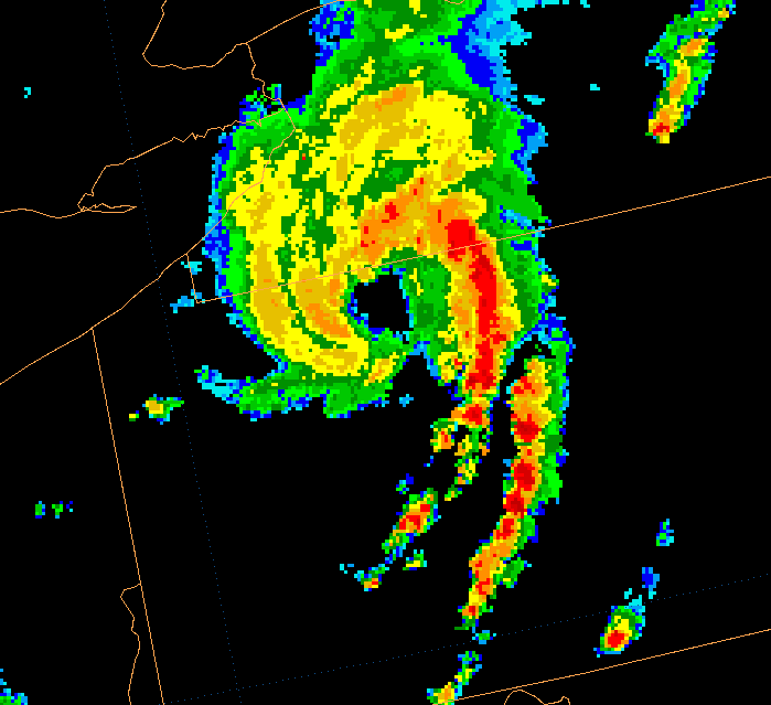
signature in the shape of a hurricane in low levels. These storms have a central eye
free of precipitations with surrounding arms of strong echoes but are really associated with a supercell thunderstorm developing a squall line. These storms are not in any way related to a hurricane other than the fact that they are shaped similarly to one, and have a warm core, like other mesoscale convective systems. The only use of the term tornadocane occurred on April 15, 1999 over Duplin County, North Carolina
, and the term does not exist in any standard dictionary or glossary.
of a supercell thunderstorm and generate a vigorous gust front at the base of the hook echo
region. If the instability and humidity of the air ahead of the front are conducive, a squall line
develops from the supercell toward the southwest (northern hemisphere
) closing the gap of the bounded weak echo region (BWER) and curving into spiral bands seemingly rotating around the BWER. The supercell itself is often associated with tornadoes while the squall line produces microburst
s.
since at least 2000. While it is not a term officially used in warnings issued by any known country's national meteorological center, the term has been used after the fact with cyclones in Australia, including a former tropical depression. Despite its informal status, the term has been used in the university setting at the University of Munich.
while assuming a hurricane shape. It exited the State as a Bow Echo
as the parent supercell decayed and the squall line took over. One tornado spawned from this supercell was .8-1.6 km (.5-1 mi) wide, caused major damage and injured 11 people along a 48 km (30 mi) long damage track.
One death and a 265 km/h (165 mph) wind gust were also reported with this storm. This wind gust is thought to have come from a direct hit to an anemometer
by a tornado, which is in the F3
windspeed range. However, since only damage can be used to rating of a tornado, that recorded wind speed is ineligible for determining the F scale rating of this tornado.
sketch played up the concept of a "Tornadocane" as being such a powerful event that they had "gained sentience and begun to commit identity theft" and that the end of days was upon us.
 Another case of tornadocane happened across the Midwest on July 21, 2003. An area of convection developed across eastern Iowa
near a weak stationary/warm front at 0302 UTC and moved to the east along it. By 1203 UTC, the convective system had matured, taking on the shape of a wavy squall line across western Ohio
and southern Indiana
. The system re-intensified after leaving the Ohio Valley, starting to form a large hook, with occasional hook echoes appearing along its eastern side. A surface low pressure became defined and became more impressive later in the day. By 2244 UTC, a squall line took shape along its band to the south. This began to starve the inner convection and by 0126 UTC, daytime heating had ceased. The squall line ran out ahead of the low, causing the entire convective structure to weaken.
Heavy rainfall and straight wind damages were the main effect of this system. It left a maximum of 102 mm (4 inches) of rain along the path of the system and numerous reports of violent winds. A few weak tornadoes have been reported too.
on May 8, 2009. A wind gust to 106 mph (170.6 km/h) occurred in Carbondale, Illinois
in association with the storm.
Mesoscale Convective System
A mesoscale convective system is a complex of thunderstorms that becomes organized on a scale larger than the individual thunderstorms but smaller than extratropical cyclones, and normally persists for several hours or more...
s that develop a weather radar
Weather radar
Weather radar, also called weather surveillance radar and Doppler weather radar, is a type of radar used to locate precipitation, calculate its motion, estimate its type . Modern weather radars are mostly pulse-Doppler radars, capable of detecting the motion of rain droplets in addition to the...
signature in the shape of a hurricane in low levels. These storms have a central eye
Eye (cyclone)
The eye is a region of mostly calm weather found at the center of strong tropical cyclones. The eye of a storm is a roughly circular area and typically 30–65 km in diameter. It is surrounded by the eyewall, a ring of towering thunderstorms where the second most severe weather of a cyclone...
free of precipitations with surrounding arms of strong echoes but are really associated with a supercell thunderstorm developing a squall line. These storms are not in any way related to a hurricane other than the fact that they are shaped similarly to one, and have a warm core, like other mesoscale convective systems. The only use of the term tornadocane occurred on April 15, 1999 over Duplin County, North Carolina
Duplin County, North Carolina
-Demographics:As of the census of 2000, there were 49,063 people, 18,267 households, and 13,060 families residing in the county. The population density was 60 people per square mile . There were 20,520 housing units at an average density of 25 per square mile...
, and the term does not exist in any standard dictionary or glossary.
Formation
These unusual thunderstorms complexes begin as the rear flank downdraftRear flank downdraft
The rear flank downdraft or RFD is a region of dry air wrapping around the back of a mesocyclone in a supercell thunderstorm. These areas of descending air are thought to be essential in the production of many supercellular tornadoes...
of a supercell thunderstorm and generate a vigorous gust front at the base of the hook echo
Hook echo
The hook echo is one of the classical hallmarks of tornado-producing supercell thunderstorms as seen on a weather radar. The echo is produced by rain, hail, or even debris being wrapped around the supercell...
region. If the instability and humidity of the air ahead of the front are conducive, a squall line
Squall line
A squall line is a line of severe thunderstorms that can form along or ahead of a cold front. In the early 20th century, the term was used as a synonym for cold front. It contains heavy precipitation, hail, frequent lightning, strong straight-line winds, and possibly tornadoes and waterspouts....
develops from the supercell toward the southwest (northern hemisphere
Northern Hemisphere
The Northern Hemisphere is the half of a planet that is north of its equator—the word hemisphere literally means “half sphere”. It is also that half of the celestial sphere north of the celestial equator...
) closing the gap of the bounded weak echo region (BWER) and curving into spiral bands seemingly rotating around the BWER. The supercell itself is often associated with tornadoes while the squall line produces microburst
Microburst
A microburst is a very localized column of sinking air, producing damaging divergent and straight-line winds at the surface that are similar to, but distinguishable from, tornadoes, which generally have convergent damage. There are two types of microbursts: wet microbursts and dry microbursts...
s.
Usage
The term landphoon has been used in AustraliaAustralia
Australia , officially the Commonwealth of Australia, is a country in the Southern Hemisphere comprising the mainland of the Australian continent, the island of Tasmania, and numerous smaller islands in the Indian and Pacific Oceans. It is the world's sixth-largest country by total area...
since at least 2000. While it is not a term officially used in warnings issued by any known country's national meteorological center, the term has been used after the fact with cyclones in Australia, including a former tropical depression. Despite its informal status, the term has been used in the university setting at the University of Munich.
North Carolina case
This tornadocane began as an HP (Heavy Precipitation) supercell on April 15, 1999, and moved across North CarolinaNorth Carolina
North Carolina is a state located in the southeastern United States. The state borders South Carolina and Georgia to the south, Tennessee to the west and Virginia to the north. North Carolina contains 100 counties. Its capital is Raleigh, and its largest city is Charlotte...
while assuming a hurricane shape. It exited the State as a Bow Echo
Bow echo
A bow echo is a term describing the characteristic radar return from a mesoscale convective system that is shaped like an archer’s bow. These systems can produce severe straight-line winds and occasionally tornadoes, causing major damage.-Research:...
as the parent supercell decayed and the squall line took over. One tornado spawned from this supercell was .8-1.6 km (.5-1 mi) wide, caused major damage and injured 11 people along a 48 km (30 mi) long damage track.
One death and a 265 km/h (165 mph) wind gust were also reported with this storm. This wind gust is thought to have come from a direct hit to an anemometer
Anemometer
An anemometer is a device for measuring wind speed, and is a common weather station instrument. The term is derived from the Greek word anemos, meaning wind, and is used to describe any airspeed measurement instrument used in meteorology or aerodynamics...
by a tornado, which is in the F3
Fujita scale
The Fujita scale , or Fujita-Pearson scale, is a scale for rating tornado intensity, based primarily on the damage tornadoes inflict on human-built structures and vegetation...
windspeed range. However, since only damage can be used to rating of a tornado, that recorded wind speed is ineligible for determining the F scale rating of this tornado.
In Popular Culture
A certain Saturday Night LiveSaturday Night Live
Saturday Night Live is a live American late-night television sketch comedy and variety show developed by Lorne Michaels and Dick Ebersol. The show premiered on NBC on October 11, 1975, under the original title of NBC's Saturday Night.The show's sketches often parody contemporary American culture...
sketch played up the concept of a "Tornadocane" as being such a powerful event that they had "gained sentience and begun to commit identity theft" and that the end of days was upon us.
Pennsylvania
Iowa
Iowa is a state located in the Midwestern United States, an area often referred to as the "American Heartland". It derives its name from the Ioway people, one of the many American Indian tribes that occupied the state at the time of European exploration. Iowa was a part of the French colony of New...
near a weak stationary/warm front at 0302 UTC and moved to the east along it. By 1203 UTC, the convective system had matured, taking on the shape of a wavy squall line across western Ohio
Ohio
Ohio is a Midwestern state in the United States. The 34th largest state by area in the U.S.,it is the 7th‑most populous with over 11.5 million residents, containing several major American cities and seven metropolitan areas with populations of 500,000 or more.The state's capital is Columbus...
and southern Indiana
Indiana
Indiana is a US state, admitted to the United States as the 19th on December 11, 1816. It is located in the Midwestern United States and Great Lakes Region. With 6,483,802 residents, the state is ranked 15th in population and 16th in population density. Indiana is ranked 38th in land area and is...
. The system re-intensified after leaving the Ohio Valley, starting to form a large hook, with occasional hook echoes appearing along its eastern side. A surface low pressure became defined and became more impressive later in the day. By 2244 UTC, a squall line took shape along its band to the south. This began to starve the inner convection and by 0126 UTC, daytime heating had ceased. The squall line ran out ahead of the low, causing the entire convective structure to weaken.
Heavy rainfall and straight wind damages were the main effect of this system. It left a maximum of 102 mm (4 inches) of rain along the path of the system and numerous reports of violent winds. A few weak tornadoes have been reported too.
Southern Midwest
Another especially significant landphoon type event took place over southern IllinoisIllinois
Illinois is the fifth-most populous state of the United States of America, and is often noted for being a microcosm of the entire country. With Chicago in the northeast, small industrial cities and great agricultural productivity in central and northern Illinois, and natural resources like coal,...
on May 8, 2009. A wind gust to 106 mph (170.6 km/h) occurred in Carbondale, Illinois
Carbondale, Illinois
Carbondale is a city in Jackson County, in the state of Illinois, within the Southern Illinois region. It is located at the junction of Illinois Route 13 and U.S. Route 51, southeast of St. Louis, Missouri, on the northern edge of the Shawnee National Forest...
in association with the storm.