

Toadstool Geologic Park
Encyclopedia
Oglala National Grassland
The Oglala National Grassland is a United States National Grassland in the northwest corner of Nebraska. It is in northern Sioux and northwestern Dawes counties, on the borders with South Dakota and Wyoming...
in far northwestern Nebraska
Nebraska
Nebraska is a state on the Great Plains of the Midwestern United States. The state's capital is Lincoln and its largest city is Omaha, on the Missouri River....
. It is operated by the United States Forest Service
United States Forest Service
The United States Forest Service is an agency of the United States Department of Agriculture that administers the nation's 155 national forests and 20 national grasslands, which encompass...
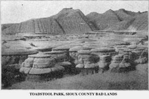
. It contains a badlands
Badlands
A badlands is a type of dry terrain where softer sedimentary rocks and clay-rich soils have been extensively eroded by wind and water. It can resemble malpaís, a terrain of volcanic rock. Canyons, ravines, gullies, hoodoos and other such geological forms are common in badlands. They are often...
landscape and a reconstructed sod house
Sod house
The sod house or "soddy" was a corollary to the log cabin during frontier settlement of Canada and the United States. The prairie lacked standard building materials such as wood or stone; however, sod from thickly-rooted prairie grass was abundant...
. The park is named after its unusual rock formations, many of which resemble toadstools
Amanita muscaria
Amanita muscaria, commonly known as the fly agaric or fly amanita , is a poisonous and psychoactive basidiomycete fungus, one of many in the genus Amanita...
.
About
Toadstool Geologic Park is said to be the "badlandsBadlands
A badlands is a type of dry terrain where softer sedimentary rocks and clay-rich soils have been extensively eroded by wind and water. It can resemble malpaís, a terrain of volcanic rock. Canyons, ravines, gullies, hoodoos and other such geological forms are common in badlands. They are often...
of Nebraska" or the "desert of the Pine Ridge
Pine Ridge (region)
The Pine Ridge is an escarpment between the Niobrara River and the White River in far northwestern Nebraska...
." The park is open 24 hours a day. Toadstool Park is north of Crawford, Nebraska
Crawford, Nebraska
Crawford is a city in Dawes County, Nebraska, United States. The population was 997 at the 2010 census. It was incorporated in 1886 and was named for the late Captain Emmet Crawford who had previously been stationed at nearby Fort Robinson.-Geography:...
; to get to the park, take Nebraska Highway 2
Nebraska Highway 2
Nebraska Highway 2 is a highway in Nebraska. It is a discontinuous highway with 2 segments. The western segment begins at the South Dakota border northwest of Crawford and ends southeast of Grand Island at an intersection with Interstate 80. The eastern segment begins in Lincoln and ends at the...
/Nebraska Highway 71
Nebraska Highway 71
Nebraska Highway 71 is a highway in western Nebraska. Its southern terminus is at the Colorado border south of Kimball, as a continuation of Colorado State Highway 71...
to Toadstool Road. There is a 1-mile loop trail within the park. There are many fossil
Fossil
Fossils are the preserved remains or traces of animals , plants, and other organisms from the remote past...
s along the trail; removing fossils is not allowed. Many fossils of large prehistoric animals such as entelodont
Entelodont
Entelodonts, sometimes nicknamed hell pigs or terminator pigs, is an extinct family of pig-like omnivores endemic to forests and plains of North America, Europe, and Asia from the middle Eocene to early Miocene epochs , existing for approximately .-Taxonomy:Entelodontidae was named by Richard...
s and hyaenodon
Hyaenodon
Hyaenodon is an extinct genus of Hyaenodonts, a group of carnivorous creodonts of the family Hyaenodontidae endemic to all continents except South America, Australia and Antarctica, living from 42—15.9 mya, existing for approximately .-Morphology:Some species of this genus were amongst the largest...
s have been found here.
Nearby attractions
- Fort RobinsonFort RobinsonFort Robinson is a former U.S. Army fort and a present-day state park. Located in the Pine Ridge region of northwest Nebraska, it is west of Crawford on U.S. Route 20.- History :...
- Hudson-Meng Bison KillHudson-Meng Bison KillThe Hudson-Meng Bison Kill site is a fossil site located in the Oglala National Grassland of western Nebraska northwest of Crawford. It contains the 10,000-year-old remains of up to 600 bison.- History :...
- Nebraska National ForestNebraska National ForestThe Nebraska National Forest is a United States National Forest located in the U.S. state of Nebraska. The total area of the national forest is ....
- Chadron State ParkChadron State ParkChadron State Park is a state park of Nebraska, USA, containing part of the Pine Ridge. The park is in northwestern Nebraska south of Chadron, within Nebraska National Forest. It is Nebraska's oldest state park, established in 1921. At , the park contains a modern campground and 16 cabins...