

Tiruvallur District
Encyclopedia
Tiruvallur district is an administrative district in the South India
n state of Tamil Nadu
. The town of Thiruvallur is the district headquarters. The district has a mixture of urban and rural characteristics. The Eastern part of Tiruvallur district is dominated by urban characteristics while the Southern and Northern part of the district has influence of Andhra culture due to its position. The languages spoken in the district are Tamil, Telugu, Hindi, Malayalam and Urdu. The district is dominated by the Hindus while people belonging to other religions are also present.
The district has been divided into three revenue divisions viz, Tiruvallur, Tiruttani
and Ponnari. There are three taluks under Thiruvallur division, two taluks under Tiruttani
divisions and four taluks under Ponneri
division. There are 46 firkas and 820 revenue villages. Likewise there are 14 blocks, 12 Municipalities and 13 town panchayats which implement rural development activities.
The district of Tiruvallur has been carved out by bifurcating erstwhile Chengalpattu district (which was renamed as Chengalpattu-MGR/Kancheepuram at the time of 1991 Census). According to the said bifurcation Tiruvallur revenue division which included Tiruvallur, Tiruttani taluks and Uthukkottai and Pallipattu sub-taluks separated from Chengalpattu district along with Ponneri and Gummindipoondi taluks of Saidapet revenue division and formed this new district. At present this district comprises nine taluks, namely Ambattur, Gummindipoondi, Ponneri, Uthukkottai, Tiruvallur, Poonamallee, Tiruttani, Pallipattu, and Madhavaram.
In the far past, this region was under a chain of regimes commencing from the Pallavas during the 7th century ending with the Nawab of Arcot during the early part of 19th century when it came under the British rule. In 1687, the Golkonda rulers were defeated and the region came under the Moghul emperors of Delhi. The towns and villages of this region were the scene of Carnatic wars. Battles are said to have been fought in this region during the struggle for supremacy between the English and French. The town of Pulicat was the earliest Dutch possession in India founded in 1609 which was ceded to the British in 1825. With this, the region came under the British rule which ended on the 15th August, 1947 with India becoming independent.
state, on the east by the Bay of Bengal
, on the southeast by Chennai district
, on the south by Kanchipuram
and on the west by Vellore district
.The coastal region of the district is mostly flat and dreary; but in the other parts it is undulating and even hilly in some places.
The northern taluks of the district like Ponneri, Uttukkottai, Gummidipundi etc. do not have much to offer from the scenic point of view. In the Tiruttani taluk, a number of hillocks are found scattered. The soil of the district is mostly sandy, mixed with soda or other alkali or stony. Rocks found in and near the surface are in detached masses. Hence, the soil can't be termed as very fertile. The soil found nearer the sea coast is of the inferior erinaceous type which is most suited for raising casuarinas plants. No mineral of any importance is available in the district. There are not many hills of any considerable height in this district. A few conical hills or ridges of small elevation exist like the St. Thomas Mount. Certain hillocks are found in Tiruttani. Most of the hills and hillocks are rocky and no verdant vegetation is seen in the slopes of these hills. The area under forests in this district is quite meager.
The average normal rainfall of the District is 1104 mm. Out of which 52% has been received during North East Monsoon period and 41% has been received during South West Monsoon period.
has a population
of 3,725,697 , roughly equal to the nation of Liberia
or the US state of Oklahoma
. This gives it a ranking of 70th in India (out of a total of 640
). The district has a population density of 1049 PD/sqkm . Its population growth rate
over the decade 2001-2011 was 35.25 %. Thiruvallur has a sex ratio
of 983 females
for every 1000 males, and a literacy rate
of 83.82 %.
It occupies an area
of 3424 km² and has a population of 2,754,756 as of 2001. It is 54.45% urbanised.
The district has a literacy of 76.90%, higher than the state average.
This district has 16940 Small Scale Industries, notable among them being food, wood, textile, chemical, engineering, non-metallic and leather industries.
There are 12 Municipalities
 In retail spending, the Thiruvallur district emerges third in India, only after Noida
and SW Delhi
surpassing Bangalore
and Mumbai
by a clear margin.
South India
South India is the area encompassing India's states of Andhra Pradesh, Karnataka, Kerala and Tamil Nadu as well as the union territories of Lakshadweep and Pondicherry, occupying 19.31% of India's area...
n state of Tamil Nadu
Tamil Nadu
Tamil Nadu is one of the 28 states of India. Its capital and largest city is Chennai. Tamil Nadu lies in the southernmost part of the Indian Peninsula and is bordered by the union territory of Pondicherry, and the states of Kerala, Karnataka, and Andhra Pradesh...
. The town of Thiruvallur is the district headquarters. The district has a mixture of urban and rural characteristics. The Eastern part of Tiruvallur district is dominated by urban characteristics while the Southern and Northern part of the district has influence of Andhra culture due to its position. The languages spoken in the district are Tamil, Telugu, Hindi, Malayalam and Urdu. The district is dominated by the Hindus while people belonging to other religions are also present.
The district has been divided into three revenue divisions viz, Tiruvallur, Tiruttani
Tiruttani
Tiruttani is a town in the Indian state of Tamil Nadu. It is one of the main tourist centre in Thiruvallur district about 84 km from Chennai. Thiruthani Murugan Temple is one of the six abodes of Lord Muruga. Tiruttani is 15 km from Andhra Pradesh state...
and Ponnari. There are three taluks under Thiruvallur division, two taluks under Tiruttani
Tiruttani
Tiruttani is a town in the Indian state of Tamil Nadu. It is one of the main tourist centre in Thiruvallur district about 84 km from Chennai. Thiruthani Murugan Temple is one of the six abodes of Lord Muruga. Tiruttani is 15 km from Andhra Pradesh state...
divisions and four taluks under Ponneri
Ponneri
Ponneri is a town, north of Chennai in Thiruvallur district in the Indian state of Tamil Nadu.- Geography :Ponneri is located at . It has an average elevation of 16 metres .- Demographics:...
division. There are 46 firkas and 820 revenue villages. Likewise there are 14 blocks, 12 Municipalities and 13 town panchayats which implement rural development activities.
Etymology
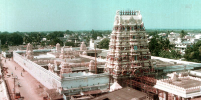
The word "Tiruvallur" is supposedly derived from the Tamil sentence "tiru evvull?" meaning, "Tiru" - god (a common prefix in South India for temple towns), "evvull" - where do I sleep. So, Tiruvallur means, a place/town where, the god, Veera Raghavar asked a saint for a place to sleep for a night.History
Tiruvallur was originally known as Tiruvallur which specifies the sleeping position of the holy lord "Balaji", in the Veeraragava temple of Tiruvallur. Later people began to refer it by names such as Trivellore and Tiruvallur. Today Tiruvallur is well known, one of the reason being the Veeraragava Temple. The new moon day is very auspicious day for the lord and so for the people of the town.The district of Tiruvallur has been carved out by bifurcating erstwhile Chengalpattu district (which was renamed as Chengalpattu-MGR/Kancheepuram at the time of 1991 Census). According to the said bifurcation Tiruvallur revenue division which included Tiruvallur, Tiruttani taluks and Uthukkottai and Pallipattu sub-taluks separated from Chengalpattu district along with Ponneri and Gummindipoondi taluks of Saidapet revenue division and formed this new district. At present this district comprises nine taluks, namely Ambattur, Gummindipoondi, Ponneri, Uthukkottai, Tiruvallur, Poonamallee, Tiruttani, Pallipattu, and Madhavaram.
In the far past, this region was under a chain of regimes commencing from the Pallavas during the 7th century ending with the Nawab of Arcot during the early part of 19th century when it came under the British rule. In 1687, the Golkonda rulers were defeated and the region came under the Moghul emperors of Delhi. The towns and villages of this region were the scene of Carnatic wars. Battles are said to have been fought in this region during the struggle for supremacy between the English and French. The town of Pulicat was the earliest Dutch possession in India founded in 1609 which was ceded to the British in 1825. With this, the region came under the British rule which ended on the 15th August, 1947 with India becoming independent.
Geography
It is bounded on the north by Andhra PradeshAndhra Pradesh
Andhra Pradesh , is one of the 28 states of India, situated on the southeastern coast of India. It is India's fourth largest state by area and fifth largest by population. Its capital and largest city by population is Hyderabad.The total GDP of Andhra Pradesh is $100 billion and is ranked third...
state, on the east by the Bay of Bengal
Bay of Bengal
The Bay of Bengal , the largest bay in the world, forms the northeastern part of the Indian Ocean. It resembles a triangle in shape, and is bordered mostly by the Eastern Coast of India, southern coast of Bangladesh and Sri Lanka to the west and Burma and the Andaman and Nicobar Islands to the...
, on the southeast by Chennai district
Chennai district
The Chennai District is a district in the state of Tamil nadu, in India. It is the smallest of all the districts in the state, but has the highest population. The district is a city district which means that it does not have a district headquarters. Most of the city region of Chennai comes under...
, on the south by Kanchipuram
Kanchipuram district
Kanchipuram district is a district in the northeast of the state of Tamil Nadu in India. It is bounded in the west by Vellore and Thiruvannamalai districts, in the north by Thiruvallur District and Chennai District, in the south by Viluppuram District and in the east by the Bay of Bengal. It lies...
and on the west by Vellore district
Vellore District
Vellore district is one of the 32 districts in the Tamil Nadu state of India. Vellore City is the headquarters of this district. It had a population of 3,477,317 as of 2001. It is 37.62% urbanised...
.The coastal region of the district is mostly flat and dreary; but in the other parts it is undulating and even hilly in some places.
The northern taluks of the district like Ponneri, Uttukkottai, Gummidipundi etc. do not have much to offer from the scenic point of view. In the Tiruttani taluk, a number of hillocks are found scattered. The soil of the district is mostly sandy, mixed with soda or other alkali or stony. Rocks found in and near the surface are in detached masses. Hence, the soil can't be termed as very fertile. The soil found nearer the sea coast is of the inferior erinaceous type which is most suited for raising casuarinas plants. No mineral of any importance is available in the district. There are not many hills of any considerable height in this district. A few conical hills or ridges of small elevation exist like the St. Thomas Mount. Certain hillocks are found in Tiruttani. Most of the hills and hillocks are rocky and no verdant vegetation is seen in the slopes of these hills. The area under forests in this district is quite meager.
The average normal rainfall of the District is 1104 mm. Out of which 52% has been received during North East Monsoon period and 41% has been received during South West Monsoon period.
Demographics
According to the 2011 census2011 census of India
The 15th Indian National census was conducted in two phases, houselisting and population enumeration. Houselisting phase began on April 1, 2010 and involved collection of information about all buildings...
has a population
Demographics of India
The demographics of India are inclusive of the second most populous country in the world, with over 1.21 billion people , more than a sixth of the world's population. Already containing 17.5% of the world's population, India is projected to be the world's most populous country by 2025, surpassing...
of 3,725,697 , roughly equal to the nation of Liberia
Liberia
Liberia , officially the Republic of Liberia, is a country in West Africa. It is bordered by Sierra Leone on the west, Guinea on the north and Côte d'Ivoire on the east. Liberia's coastline is composed of mostly mangrove forests while the more sparsely populated inland consists of forests that open...
or the US state of Oklahoma
Oklahoma
Oklahoma is a state located in the South Central region of the United States of America. With an estimated 3,751,351 residents as of the 2010 census and a land area of 68,667 square miles , Oklahoma is the 28th most populous and 20th-largest state...
. This gives it a ranking of 70th in India (out of a total of 640
Districts of India
A district is an administrative division of an Indian state or territory. Districts are further subdivided, in some cases into Sub-Divisions, and otherwise directly into tehsils or talukas.District officials include:...
). The district has a population density of 1049 PD/sqkm . Its population growth rate
Family planning in India
Family planning in India is based on efforts largely sponsored by the Indian government. In the 1965-2009 period, contraceptive usage has more than tripled and the fertility rate has more than halved , but the national fertility rate is still high enough to cause long-term population growth...
over the decade 2001-2011 was 35.25 %. Thiruvallur has a sex ratio
Sex ratio
Sex ratio is the ratio of males to females in a population. The primary sex ratio is the ratio at the time of conception, secondary sex ratio is the ratio at time of birth, and tertiary sex ratio is the ratio of mature organisms....
of 983 females
Women in India
The status of women in India has been subject to many great changes over the past few millennia. From equal status with men in ancient times through the low points of the medieval period, to the promotion of equal rights by many reformers, the history of women in India has been eventful...
for every 1000 males, and a literacy rate
Literacy in India
Literacy in India is key for socio-economic progress, and the Indian literacy rate grew to 74.04% in 2011 from 12% at the end of British rule in 1947. Although this was a greater than sixfold improvement, the level is well below the world average literacy rate of 84%, and India currently has the...
of 83.82 %.
It occupies an area
Area
Area is a quantity that expresses the extent of a two-dimensional surface or shape in the plane. Area can be understood as the amount of material with a given thickness that would be necessary to fashion a model of the shape, or the amount of paint necessary to cover the surface with a single coat...
of 3424 km² and has a population of 2,754,756 as of 2001. It is 54.45% urbanised.
The district has a literacy of 76.90%, higher than the state average.
Economy
Tiruvallur district is one of the fastest developing districts in Tamil Nadu in terms of Industrial Development. The district has many leading industries like Madras Refineries, Madras Fertilizers, Manali Petro Chemicals, MRF, Ashok Leyland, TI Cycles, Britannia India Ltd, Parry India Ltd and Hindustan Motors. It also boasts of the Ennore Thermal Power Station and the Avadi Tank Factory. The District has 16 Industrial Estates, all in operation : 11 developed by the Government and 5 by Private Organisation.Government
- Ambattur Industrial Estate, Ambattur.
- Electrical Industrial Estate, Kakalur.
- SIDCO Industrial Estate, Chennai - 98.
- Industrial Estate, Madhavaram.
- SIDCO Industrial Estate, Kakalur
- Petrochemical Industrial Estate, Vichoor
- SIDCO Industrial Estate, R.K. Pet
- SIDCO Industrial Estate, Gummidipoondi
- Industrial Estate, Mugappair
Private
- G.K. Industrial Estate, Porur
- M.M.Industrial Estate, Alapakkam
- Moccaram Industries, Velappan Chavadi
- Nagappa Industrial Estate, Puzhal
- Ekambara Naicker Industrial Estate, Alapakkam
This district has 16940 Small Scale Industries, notable among them being food, wood, textile, chemical, engineering, non-metallic and leather industries.
Administration
The following are the Taluks of the district.- TiruvallurTiruvallurTiruvallur is a temple town and Grade I municipality in Tiruvallur district in the Indian state of Tamil Nadu. It is located on the Cooum river about northwest of the city of Chennai , the capital city of Tamil Nadu. It is the administrative headquarters of Tiruvallur district...
- PoonamalleePoonamalleePoonamallee is a town in the Poonamallee taluk of the Thiruvallur district in the Indian state of Tamil Nadu...
- PonneriPonneriPonneri is a town, north of Chennai in Thiruvallur district in the Indian state of Tamil Nadu.- Geography :Ponneri is located at . It has an average elevation of 16 metres .- Demographics:...
- GummidipoondiGummidipoondiGummidipoondi is an industrial town in Thiruvallur district in the Indian state of Tamil Nadu.Gummdipoondi lies on the National Highway 5 from Chennai to Calcutta. This road is part of the Golden Quadrilateral which is a project launched by the Vajpayee Government...
- UthukottaiUthukottaiUthukottai is a border town in Tamil Nadu next to Andra Pradesh, on the banks of the Arani river. It has a channel which helps channel water from the Krishna river to Tamil Nadu....
- TiruttaniTiruttaniTiruttani is a town in the Indian state of Tamil Nadu. It is one of the main tourist centre in Thiruvallur district about 84 km from Chennai. Thiruthani Murugan Temple is one of the six abodes of Lord Muruga. Tiruttani is 15 km from Andhra Pradesh state...
- PallipattuPallipattuPallipat is a town in Tiruvallur district in the state of Tamil Nadu, India .-Geography:Pallipat is located at . It has an average elevation of 154 metres .-Demographics:...
- AmbatturAmbattur-Administration:Ambattur comes under the new Sriperumbudur parliamentary constituency. It was previously under the North Chennai parliamentary constituency and along with Villivakkam, it was the largest assembly constituency in India. The delimitation process of assembly constituencies has given...
- Madhavaram
There are 12 Municipalities
- Ambattur
- Avadi
- Kattivakkam
- Madavaram
- Maduravayal
- Manali
- Poonamallee
- Tiruttani
- Tiruvallur
- Tiruverkadu
- Tiruvottiyur
- Valasaravakkam
Economy
Noida
Noida , short for the New Okhla Industrial Development Area, is an area in India under the management of the New Okhla Industrial Development Authority . Noida came into administrative existence on 17 April 1976 and celebrates 17 April as "Noida Day". It was set up as part of an urbanization...
and SW Delhi
Delhi
Delhi , officially National Capital Territory of Delhi , is the largest metropolis by area and the second-largest by population in India, next to Mumbai. It is the eighth largest metropolis in the world by population with 16,753,265 inhabitants in the Territory at the 2011 Census...
surpassing Bangalore
Bangalore
Bengaluru , formerly called Bengaluru is the capital of the Indian state of Karnataka. Bangalore is nicknamed the Garden City and was once called a pensioner's paradise. Located on the Deccan Plateau in the south-eastern part of Karnataka, Bangalore is India's third most populous city and...
and Mumbai
Mumbai
Mumbai , formerly known as Bombay in English, is the capital of the Indian state of Maharashtra. It is the most populous city in India, and the fourth most populous city in the world, with a total metropolitan area population of approximately 20.5 million...
by a clear margin.
Administration and Politics
| Assembly Constituency |
Political Party |
Elected Representative |
|---|---|---|
| Gummidipoondi Gummidipoondi Gummidipoondi is an industrial town in Thiruvallur district in the Indian state of Tamil Nadu.Gummdipoondi lies on the National Highway 5 from Chennai to Calcutta. This road is part of the Golden Quadrilateral which is a project launched by the Vajpayee Government... |
DMDK | C. H. Shekar C. H. Shekar C. H. Shekar is an Indian politician and incumbent Member of the Tamil Nadu Legislative Assembly from the Gummidipundi constituency. He represents the Desiya Murpokku Dravidar Kazhagam party.- References :... |
| Ponneri Ponneri Ponneri is a town, north of Chennai in Thiruvallur district in the Indian state of Tamil Nadu.- Geography :Ponneri is located at . It has an average elevation of 16 metres .- Demographics:... |
AIADMK | Pon. Raja Pon. Raja Pon. Raja is an Indian politician and incumbent Member of the Tamil Nadu Legislative Assembly from the Ponneri constituency. He represents the Anna Dravida Munnetra Kazhagam party.- References :... |
| Tiruvottiyur Tiruvottiyur Tiruvottiyur is located within the city premises of Chennai. It is located to the north of Chennai. Due to its proximity to Parrys and Chennai Central, it is fast becoming a sought after residential destination... |
AIADMK | K. Kuppan |
| Ambattur Ambattur -Administration:Ambattur comes under the new Sriperumbudur parliamentary constituency. It was previously under the North Chennai parliamentary constituency and along with Villivakkam, it was the largest assembly constituency in India. The delimitation process of assembly constituencies has given... |
AIADMK | S. Vedachalam |
| Poonamallee Poonamallee Poonamallee is a town in the Poonamallee taluk of the Thiruvallur district in the Indian state of Tamil Nadu... |
AIADMK | R. Manimaran |
| Tiruvallur Tiruvallur Tiruvallur is a temple town and Grade I municipality in Tiruvallur district in the Indian state of Tamil Nadu. It is located on the Cooum river about northwest of the city of Chennai , the capital city of Tamil Nadu. It is the administrative headquarters of Tiruvallur district... |
AIADMK | B. V. Ramanaa B. V. Ramanaa B. V. Ramanaa is an Indian politician and incumbent member of the Tamil Nadu legislative assembly from Tiruvallur constituency. He is currently the Minister for Environment, Government of Tamil Nadu. He represents Anna Dravida Munnetra Kazhagam party.... |
| Madavaram Madavaram Madhavaram is a greater municipality in Thiruvallur district in the Indian state of Tamil Nadu. Madhavaram is one among the nine taluks namely Ambattur, Gummindipoondi, Ponneri, Uthukkottai, Tiruvallur, Poonamallee, Tiruttani and Pallipattu, Madhavaram of Thiruvallur district. Madhavaram is a... |
AIADMK | Moorthy Moorthy Moorthy is a character in Raja Rao's novel Kanthapura, which records the influence of Gandhian ideals on a remote South Indian village during the years of the Indian independence movement. Though it is a story of Gandhiji's charismatic effect on the village, the Mahatma does not appear in the novel... |
| Maduravoyal Maduravoyal Maduravoyal is a suburb of Chennai in Thiruvallur district in the Indian state of Tamil Nadu. It is located 2 miles west of Chennai corporation limits. It is on the Chennai-Bangalore National highway. The second phase of Chennai Bypass cuts through Maduravoyal to reach the northern borders of... |
CPI-M | Bhima Rao |
| Tiruttani Tiruttani Tiruttani is a town in the Indian state of Tamil Nadu. It is one of the main tourist centre in Thiruvallur district about 84 km from Chennai. Thiruthani Murugan Temple is one of the six abodes of Lord Muruga. Tiruttani is 15 km from Andhra Pradesh state... |
DMDK | M. Arun Subramanian M. Arun Subramanian M. Arun Subramanian is an Indian politician and incumbent Member of the Tamil Nadu Legislative Assembly from the Tiruttani constituency. He represents the Desiya Murpokku Dravidar Kazhagam party.- References :... |
| Lok Sabha Constituency |
Political Party |
Elected Representative |
| Thiruvallur | AIADMK | P. Venugopal P. Venugopal P. Venugopal is an Indian politician and incumbent member of the Parliament of India from Thiruvallur Constituency. He represents the All India Anna Dravida Munnetra Kazhagam party.- References :... |
| Source: Indian Elections / Election Commission of India. | ||
External links
- Sri Anandavalli Sametha Thirunandeeswarar Temple, Manavur, Tiruvallur District
- Tiruvallur District
- Website of Sri Viswaroopa Panchamukha Hanuman Ashram
- Website of Loka Kshema Yagna Trust - charitable organization based in Tiruvallur