

Tiruchirappalli district
Encyclopedia
Tiruchirapalli District also known as Tiruchchirapalli District or Trichy District, is located along the Kaveri River
in Tamil Nadu
, India
. The main town in Tiruchirapalli District is the city of Tiruchirapalli
, also known as Trichy.
During the British Raj
, Tiruchirapalli was known as Trichinopoly
, and was a district of the Madras Presidency
; it was renamed upon India's declaration of independence in 1947.
 Tiruchirapalli district lies at the heart of Tamil Nadu. The district has an area of 4,404 square kilometers. It is bounded in the northwest by Namakkal district
, in the northeast by Perambalur district, in the east by Thanjavur district
, in the southeast by Pudukkottai district
, in the south by Madurai district
and Sivagangai district, in the southwest by Dindigul district
and, in the west by Karur district
. Kaveri river flows through the length of the district and is the principal source of irrigation and water supply.
Tiruchirapalli district has a population
of 2,713,858, roughly equal to the nation of Kuwait
or the US state of Nevada
. This gives it a ranking of 146th in India (out of a total of 640
). The district has a population density of 602 PD/sqkm . Its population growth rate
over the decade 2001-2011 was 12.22 %. Tiruchirappalli has a sex ratio
of 1013 females
for every 1000 males, and a literacy rate
of 83.56 %.
According to the 2011 provisional population results, the district has a population of 2,713,858. The density is 602 persons per km2. The district has a literacy of 83.6%, higher than the state's average.
Tamil
is the principal language spoken and Tamils
are the predominant linguistic group in the district. Considerable amount of Sri Lankan Tamils are also found in certain pockets of Tiruchirapalli. Hindus formed the majority of the population at 84.39% of the population followed by Christians at 9.02%, Muslims at 6.46% and others at 0.12%.
.jpg) Tiruchirapalli District consists of 8 Taluks:
Tiruchirapalli District consists of 8 Taluks:
 Tiruchirapalli District consists of the following urban centres:
Kaveri River
The Kaveri , also spelled Cauvery in English, is a large Indian river. The origin of the river is traditionally placed at Talakaveri, Kodagu in the Western Ghats in Karnataka, flows generally south and east through Karnataka and Tamil Nadu and across the southern Deccan plateau through the...
in Tamil Nadu
Tamil Nadu
Tamil Nadu is one of the 28 states of India. Its capital and largest city is Chennai. Tamil Nadu lies in the southernmost part of the Indian Peninsula and is bordered by the union territory of Pondicherry, and the states of Kerala, Karnataka, and Andhra Pradesh...
, India
India
India , officially the Republic of India , is a country in South Asia. It is the seventh-largest country by geographical area, the second-most populous country with over 1.2 billion people, and the most populous democracy in the world...
. The main town in Tiruchirapalli District is the city of Tiruchirapalli
Tiruchirapalli
Tiruchirappalli ) , also called Tiruchi or Trichy , is a city in the Indian state of Tamil Nadu and the administrative headquarters of Tiruchirappalli District. It is the fourth largest municipal corporation in Tamil Nadu and also the fourth largest urban agglomeration in the state...
, also known as Trichy.
During the British Raj
British Raj
British Raj was the British rule in the Indian subcontinent between 1858 and 1947; The term can also refer to the period of dominion...
, Tiruchirapalli was known as Trichinopoly
Trichinopoly District (Madras Presidency)
The Trichinopoly district was a district of the erstwhile Madras Presidency of British India. It covered the present-day districts of Tiruchirappalli, Karur, Ariyalur and Perambalur in the Indian state of Tamil Nadu. The administrative headquarters was the town of Trichinopoly, Trichy or Tiruchi,...
, and was a district of the Madras Presidency
Madras Presidency
The Madras Presidency , officially the Presidency of Fort St. George and also known as Madras Province, was an administrative subdivision of British India...
; it was renamed upon India's declaration of independence in 1947.
Geography
Namakkal District
Namakkal District is an administrative district in the state of Tamil Nadu, India. The district was bifurcated from Salem District with Namakkal town as Head Quarters on 25-07-1996 and started to function independently from 01-01-1997...
, in the northeast by Perambalur district, in the east by Thanjavur district
Thanjavur District
Thanjavur District is one of the 32 districts of the state of Tamil Nadu, in southeastern India. Its headquarters is Thanjavur.-Geography:...
, in the southeast by Pudukkottai district
Pudukkottai District
Pudukkottai District is a district of Tamil Nadu state in southern India. The city of Pudukkottai is the district headquarters...
, in the south by Madurai district
Madurai District
Madurai district is one of the 32 districts of the state of Tamil Nadu, in southeastern India. The city of Madurai serves as the district headquarters. It houses the world famous Sri Meenakshi Sundareshwarar temple and is situated on the banks of river Vaigai. Thiruparankundram is one of the major...
and Sivagangai district, in the southwest by Dindigul district
Dindigul District
Dindigul District is an administrative region in the south of Tamil Nadu, India. The district was carved out of Madurai District in the year 1985...
and, in the west by Karur district
Karur District
Karur District is located center along the Kaveri & Amaravati rivers in the Indian State of Tamil Nadu. The main town in Karur District is the city of Karur, which is also the district headquarter. It had a population of 935,686 as of 2001. It is 33.27% urbanized as per Census 2001...
. Kaveri river flows through the length of the district and is the principal source of irrigation and water supply.
Demographics
According to the 2011 census2011 census of India
The 15th Indian National census was conducted in two phases, houselisting and population enumeration. Houselisting phase began on April 1, 2010 and involved collection of information about all buildings...
Tiruchirapalli district has a population
Demographics of India
The demographics of India are inclusive of the second most populous country in the world, with over 1.21 billion people , more than a sixth of the world's population. Already containing 17.5% of the world's population, India is projected to be the world's most populous country by 2025, surpassing...
of 2,713,858, roughly equal to the nation of Kuwait
Kuwait
The State of Kuwait is a sovereign Arab state situated in the north-east of the Arabian Peninsula in Western Asia. It is bordered by Saudi Arabia to the south at Khafji, and Iraq to the north at Basra. It lies on the north-western shore of the Persian Gulf. The name Kuwait is derived from the...
or the US state of Nevada
Nevada
Nevada is a state in the western, mountain west, and southwestern regions of the United States. With an area of and a population of about 2.7 million, it is the 7th-largest and 35th-most populous state. Over two-thirds of Nevada's people live in the Las Vegas metropolitan area, which contains its...
. This gives it a ranking of 146th in India (out of a total of 640
Districts of India
A district is an administrative division of an Indian state or territory. Districts are further subdivided, in some cases into Sub-Divisions, and otherwise directly into tehsils or talukas.District officials include:...
). The district has a population density of 602 PD/sqkm . Its population growth rate
Family planning in India
Family planning in India is based on efforts largely sponsored by the Indian government. In the 1965-2009 period, contraceptive usage has more than tripled and the fertility rate has more than halved , but the national fertility rate is still high enough to cause long-term population growth...
over the decade 2001-2011 was 12.22 %. Tiruchirappalli has a sex ratio
Sex ratio
Sex ratio is the ratio of males to females in a population. The primary sex ratio is the ratio at the time of conception, secondary sex ratio is the ratio at time of birth, and tertiary sex ratio is the ratio of mature organisms....
of 1013 females
Women in India
The status of women in India has been subject to many great changes over the past few millennia. From equal status with men in ancient times through the low points of the medieval period, to the promotion of equal rights by many reformers, the history of women in India has been eventful...
for every 1000 males, and a literacy rate
Literacy in India
Literacy in India is key for socio-economic progress, and the Indian literacy rate grew to 74.04% in 2011 from 12% at the end of British rule in 1947. Although this was a greater than sixfold improvement, the level is well below the world average literacy rate of 84%, and India currently has the...
of 83.56 %.
According to the 2011 provisional population results, the district has a population of 2,713,858. The density is 602 persons per km2. The district has a literacy of 83.6%, higher than the state's average.
Tamil
Tamil language
Tamil is a Dravidian language spoken predominantly by Tamil people of the Indian subcontinent. It has official status in the Indian state of Tamil Nadu and in the Indian union territory of Pondicherry. Tamil is also an official language of Sri Lanka and Singapore...
is the principal language spoken and Tamils
Tamil people
Tamil people , also called Tamils or Tamilians, are an ethnic group native to Tamil Nadu, India and the north-eastern region of Sri Lanka. Historic and post 15th century emigrant communities are also found across the world, notably Malaysia, Singapore, Mauritius, South Africa, Australia, Canada,...
are the predominant linguistic group in the district. Considerable amount of Sri Lankan Tamils are also found in certain pockets of Tiruchirapalli. Hindus formed the majority of the population at 84.39% of the population followed by Christians at 9.02%, Muslims at 6.46% and others at 0.12%.
Taluks
- ManapparaiManapparaiManapparai is a town and a municipality in Tiruchirappalli district in the Indian state of Tamil Nadu. Manapparai is the headquarters of the Manapparai Taluk-Demographics:...
- SrirangamSrirangamSrirangam , Old name is Vellithirumutha gramam and Tamil name is Thiruvarangam , is an island and a part of the city of Tiruchirapalli , in South India....
- TiruchirapalliTiruchirapalliTiruchirappalli ) , also called Tiruchi or Trichy , is a city in the Indian state of Tamil Nadu and the administrative headquarters of Tiruchirappalli District. It is the fourth largest municipal corporation in Tamil Nadu and also the fourth largest urban agglomeration in the state...
- LalgudiLalgudiLalgudi is a town in Tiruchirapalli district in the Indian state of Tamil Nadu.-Geography:Lalgudi is a town located around 20KM from Tiruchirapalli on NH227 Tiruchirapalli-Chidambaram. Lalgudi lies close to Coleroon River...
- ManachanallurManachanallurManachanallur is a panchayat town in Tiruchirappalli district in the Indian state of Tamil Nadu. It is well known for its numerous rice mills and is the location of one of Tiruchirappali's best colleges, Chidambaram Pillai Women's College, a college founded by the well known R.M.S.T family of...
- ThuraiyurThuraiyurThuraiyur is a town and a municipality in Tiruchirappalli district in the Indian state of Tamil Nadu. Thuraiyur Municipality - It was upgraded to III Grade Municipality from Town Panchayat on 17.01.1970. It was upgraded to II Grade Municipality in May 1998.- Economy :Two decades ago agriculture...
- MusiriMusiriMusiri is a panchayat town in Tiruchirappalli district in the Indian state of Tamil Nadu. Musiri is located at . It has an average elevation of 82 metres . It is the site of an ancient inland port on the Kaveri River also called Pseudostomus or 'one with false mouths'.-Demographics: India...
- ThottiyamThottiyamThottiyam is a panchayat town in Tiruchirappalli district in the Indian state of Tamil Nadu. It is situated 60 km north-west of Tiruchirapalli on Tiruchy-Namakkal State Highway and further it connects Namakkal-Salem-Bangalore National Highway...
Urban centres
- Trichy city
- ManapparaiManapparaiManapparai is a town and a municipality in Tiruchirappalli district in the Indian state of Tamil Nadu. Manapparai is the headquarters of the Manapparai Taluk-Demographics:...
town - ThuraiyurThuraiyurThuraiyur is a town and a municipality in Tiruchirappalli district in the Indian state of Tamil Nadu. Thuraiyur Municipality - It was upgraded to III Grade Municipality from Town Panchayat on 17.01.1970. It was upgraded to II Grade Municipality in May 1998.- Economy :Two decades ago agriculture...
town - ThuvakudiThuvakudiThuvakudi is a 3rd Grade Municipality in Tiruchirappalli City in the Indian state of Tamil Nadu. It is approximately 335 km from the nearest cosmopolis — Chennai...
town - LalgudiLalgudiLalgudi is a town in Tiruchirapalli district in the Indian state of Tamil Nadu.-Geography:Lalgudi is a town located around 20KM from Tiruchirapalli on NH227 Tiruchirapalli-Chidambaram. Lalgudi lies close to Coleroon River...
town panchayat - ManachanallurManachanallurManachanallur is a panchayat town in Tiruchirappalli district in the Indian state of Tamil Nadu. It is well known for its numerous rice mills and is the location of one of Tiruchirappali's best colleges, Chidambaram Pillai Women's College, a college founded by the well known R.M.S.T family of...
town panchayat - MusiriMusiriMusiri is a panchayat town in Tiruchirappalli district in the Indian state of Tamil Nadu. Musiri is located at . It has an average elevation of 82 metres . It is the site of an ancient inland port on the Kaveri River also called Pseudostomus or 'one with false mouths'.-Demographics: India...
town panchayat - ThottiyamThottiyamThottiyam is a panchayat town in Tiruchirappalli district in the Indian state of Tamil Nadu. It is situated 60 km north-west of Tiruchirapalli on Tiruchy-Namakkal State Highway and further it connects Namakkal-Salem-Bangalore National Highway...
town panchayat - Kolli HillsKolli HillsKolli Hills or Kolli Malai is a small mountain range located in central Tamil Nadu in Namakkal district of India. The mountains are about 1000 to 1300 m in height and cover an area of approximately 280 km². The Kolli Hills has 72 hair pin bends to reach the top of the hills...
(Kollimalai) tourist town
Major industries
- Boiler Manufacturing Industries
- Cement Factories
- Light and heavy engineering
- Leather Tanneries
- Food processing Industries
- Sugar Mills
- (Traditional) Cigar Making (village) Industries.
- Hosiery and garments (to a small extent)
- IT/BPO
Natural resources and water bodies
- River Cauvery
- River Coleeron
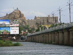
Tourism
Places to visit in Tiruchirappalli District.- Mukkombu
- Srirangam Temple
- Thiruvanai koil
- Vayalur Murugan Temple
- Kulumandi Amman Temple,Puthur-Sholanganallur
- Samayapuram Mariamman Temple
- Vekkaliamman Temple, Woriyur
- Rock Fort and Uchipillaiyar Temple
- Kallanai
Major crops
The rivers Cauvery and Coleeron start branching out to form the Cauvery delta irrigating vast tracts of land in the district.- Rice (vast tracts)
- Sugarcane (vast tracts)
- Banana/plantain
- Coconut
- Cotton (small tracts)
- betel
- Corn
- groundnut