

Thurlby by Bourne
Encyclopedia
Thurlby is a village and civil parish in the District of South Kesteven
in the English
county of Lincolnshire
, on the edge of The Fens
. It is sometimes referred to as Thurlby by Bourne to distinguish it from other villages in Lincolnshire called Thurlby. The parish had a population of 2,136 at the 2001 census, although this has increased by hundreds as of the 2011 census.
 Geographically Thurlby is on the western edge of the Lincolnshire fens
.
Thurlby lies between Bourne
and Baston
, at . Most of the village lies to the west of the A15 road but a part, including the parish church, is to the east. A Methodist chapel, Trinity Methodist Church, was established in 1912. The parish includes Northorpe
, which is continuous with Thurlby, and the outlying hamlets of Obthorpe
and Kate's Bridge
.
Thurlby Fen, to the east of the main road, falls within the drainage area of the Welland and Deepings Internal Drainage Board
.
The ecclesiastical parish of Thurlby share the same boundaries as the civil parish, with a single parish church
of St Firmin. This is part of the Ness group of the Deanery
of Aveland
and Ness with Stamford. The incumbent is Rev Canon Janet M Beadle .
Thurlby also has a hill, this hill is called Swallow Hill, on the hill there are many houses and up until around 1998, there was very little pavement near the top and people had to walk on the road. There is also a small estate with a 'private' road. This estate is called Swift Way. (Known as Swallow Heights during the development phase).
There is one public house, called the Horseshoe, located on the A15/High street junction. The village has a modern primary school sharing a site with the community hall and Lawrance Park a shop with post office, and a Veterinary practice.. A pre-school also exists halfway up Northorpe from the A15.
A firm of agricultural engineers, a furniture store, and a petrol station operate in Kate's Bridge.
Northorpe and Thurlby are served by half-hourly Delaine buses between Bourne
, Lincolnshire
, and Peterborough
, Cambridgeshire
, and a daily service to Stamford
, Lincolnshire
. Buses arrive from Bourne en route to Peterborough at 7 minutes and 37 minutes past the hour at Northorpe, and 8 minutes and 38 minutes past the hour at Thurlby. Buses arrive from Peterborough en route to Bourne at 28 minutes and 58 minutes past the hour at Thurlby, and 29 minutes and 59 minutes past the hour at Northorpe.
The nearest airport to the village is East Midlands Airport, which is situated in the neighbouring county of Leicestershire, with regular flights across Europe. The nearest train stations are located at Stamford and at Peterborough, both with regular scheduled services to London King's Cross.
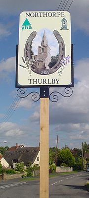
In 1979 a local resident, Mr Harold Sneath, bequeathed his home, Capstones, to the Youth Hostels Association
(YHA) to use as youth hostel
. Following the foot and mouth crisis of 2001 YHA looked to close the hostel to reduce costs. Lincolnshire County Council and South Kesteven District Council
were opposed to the closure and resolution was achieved by the two councils buying the building and leasing it back to YHA. The signpost for Thurlby now shows the YHA logo on it to reflect the ownership of the hostel.
passes through the parish to the east of the road. The A151 road itself broadly follows the route of the Roman Road
King street
.
The church of St Firmin dates back to before the Norman Conquest, reportedly to 925 AD. It has features of Saxo-norman and Perpendicular style.
Thurlby is mentioned in the Domesday survey as Turolvebi.
Thurlby railway station
was on the Bourne and Essendine railway, opened in 1860 and closed in 1951.
The races are usually held on the first Sunday in July.
Lawrance Park at comprises the community hall, large park and childrens play area. It is a sporting venue in the village, with many events taking place both in the hall (circuit training, indoor bowls and line dancing) and on the park (football and school games). Hourly Taekwondo
lessons may be undertaken at the Lawrance Park Hall every Wednesday at 7.30pm and Saturday at 11.30am. Thurlby also has a small but enthusiastic tennis club.
Thurlby has two football teams. The junior side Thurlby Tigers and the mens side Thurlby United. Both sides play home fixtures at Lawrance Park.
Car boot sales take place at Lawrance Park twice a year, at the end of March and the end of September.
South Kesteven
South Kesteven is a local government district in Lincolnshire, England, forming part of the traditional Kesteven division of the county. It covers Grantham, Stamford, Bourne and Market Deeping.-History:...
in the English
England
England is a country that is part of the United Kingdom. It shares land borders with Scotland to the north and Wales to the west; the Irish Sea is to the north west, the Celtic Sea to the south west, with the North Sea to the east and the English Channel to the south separating it from continental...
county of Lincolnshire
Lincolnshire
Lincolnshire is a county in the east of England. It borders Norfolk to the south east, Cambridgeshire to the south, Rutland to the south west, Leicestershire and Nottinghamshire to the west, South Yorkshire to the north west, and the East Riding of Yorkshire to the north. It also borders...
, on the edge of The Fens
The Fens
The Fens, also known as the , are a naturally marshy region in eastern England. Most of the fens were drained several centuries ago, resulting in a flat, damp, low-lying agricultural region....
. It is sometimes referred to as Thurlby by Bourne to distinguish it from other villages in Lincolnshire called Thurlby. The parish had a population of 2,136 at the 2001 census, although this has increased by hundreds as of the 2011 census.
The Village
The Fens
The Fens, also known as the , are a naturally marshy region in eastern England. Most of the fens were drained several centuries ago, resulting in a flat, damp, low-lying agricultural region....
.
Thurlby lies between Bourne
Bourne, Lincolnshire
Bourne is a market town and civil parish on the western edge of the Fens, in the District of South Kesteven in southern Lincolnshire, England.-The town:...
and Baston
Baston
Baston is a parish on the edge of The Fens and in the administrative district of South Kesteven, Lincolnshire, England. Like most fen-edge parishes, it was laid out more than a thousand years ago, in an elongated form, to afford the produce from a variety of habitats for the villagers...
, at . Most of the village lies to the west of the A15 road but a part, including the parish church, is to the east. A Methodist chapel, Trinity Methodist Church, was established in 1912. The parish includes Northorpe
Northorpe
Northorpe is a growing hamlet in the parish of Thurlby, in South Kesteven, southern Lincolnshire and is about a mile south of Bourne.Northorpe is near to Elsea and Math Woods, the latter of which is rumored to be haunted by Nanny Rutt, but they are still popular places in which to walk dogs...
, which is continuous with Thurlby, and the outlying hamlets of Obthorpe
Obthorpe
Obthorpe is a hamlet located in the English county of Lincolnshire.It is about a mile south of the village of Thurlby and is in its civil parish that, in turn, forms part of the district of South Kesteven....
and Kate's Bridge
Kate's Bridge
Kate's Bridge is a landmark settlement on the A15 road, in the parish of Thurlby, about south of Bourne, Lincolnshire, England. Its size is indicated by the fact that the road signs announcing it at its two ends are on the same pole....
.
Thurlby Fen, to the east of the main road, falls within the drainage area of the Welland and Deepings Internal Drainage Board
Internal Drainage Board
An internal drainage board is a type of operating authority which is established in areas of special drainage need in England and Wales with permissive powers to undertake work to secure clean water drainage and water level management within drainage districts...
.
The ecclesiastical parish of Thurlby share the same boundaries as the civil parish, with a single parish church
Parish church
A parish church , in Christianity, is the church which acts as the religious centre of a parish, the basic administrative unit of episcopal churches....
of St Firmin. This is part of the Ness group of the Deanery
Deanery
A Deanery is an ecclesiastical entity in both the Roman Catholic Church and the Church of England. A deanery is either the jurisdiction or residence of a Dean.- Catholic usage :...
of Aveland
Aveland
Aveland was a Wapentake of Kesteven from the time of the Danelaw until the Local Government Act 1888. Its meeting place was The Aveland at in the parish of Aslackby.-Origins:...
and Ness with Stamford. The incumbent is Rev Canon Janet M Beadle .
Thurlby also has a hill, this hill is called Swallow Hill, on the hill there are many houses and up until around 1998, there was very little pavement near the top and people had to walk on the road. There is also a small estate with a 'private' road. This estate is called Swift Way. (Known as Swallow Heights during the development phase).
There is one public house, called the Horseshoe, located on the A15/High street junction. The village has a modern primary school sharing a site with the community hall and Lawrance Park a shop with post office, and a Veterinary practice.. A pre-school also exists halfway up Northorpe from the A15.
A firm of agricultural engineers, a furniture store, and a petrol station operate in Kate's Bridge.
Northorpe and Thurlby are served by half-hourly Delaine buses between Bourne
Bourne
-General:*A winterbourne * Bourne , a surname*The Bourne shell, in Unix*Jason Bourne, a fictional character who is the protagonist of a trilogy of novels by Robert Ludlum and of a film series based on the books*Bourne Co...
, Lincolnshire
Lincolnshire
Lincolnshire is a county in the east of England. It borders Norfolk to the south east, Cambridgeshire to the south, Rutland to the south west, Leicestershire and Nottinghamshire to the west, South Yorkshire to the north west, and the East Riding of Yorkshire to the north. It also borders...
, and Peterborough
Peterborough
Peterborough is a cathedral city and unitary authority area in the East of England, with an estimated population of in June 2007. For ceremonial purposes it is in the county of Cambridgeshire. Situated north of London, the city stands on the River Nene which flows into the North Sea...
, Cambridgeshire
Cambridgeshire
Cambridgeshire is a county in England, bordering Lincolnshire to the north, Norfolk to the northeast, Suffolk to the east, Essex and Hertfordshire to the south, and Bedfordshire and Northamptonshire to the west...
, and a daily service to Stamford
Stamford
-Places:In the United Kingdom:*Stamford, Lincolnshire, a town in England*Stamford Hill, London*Stamford Bridge, East Riding of Yorkshire**Battle of Stamford Bridge*Stamford Bridge , the home ground for Chelsea Football Club...
, Lincolnshire
Lincolnshire
Lincolnshire is a county in the east of England. It borders Norfolk to the south east, Cambridgeshire to the south, Rutland to the south west, Leicestershire and Nottinghamshire to the west, South Yorkshire to the north west, and the East Riding of Yorkshire to the north. It also borders...
. Buses arrive from Bourne en route to Peterborough at 7 minutes and 37 minutes past the hour at Northorpe, and 8 minutes and 38 minutes past the hour at Thurlby. Buses arrive from Peterborough en route to Bourne at 28 minutes and 58 minutes past the hour at Thurlby, and 29 minutes and 59 minutes past the hour at Northorpe.
The nearest airport to the village is East Midlands Airport, which is situated in the neighbouring county of Leicestershire, with regular flights across Europe. The nearest train stations are located at Stamford and at Peterborough, both with regular scheduled services to London King's Cross.
In 1979 a local resident, Mr Harold Sneath, bequeathed his home, Capstones, to the Youth Hostels Association
Youth Hostels Association (England & Wales)
The Youth Hostels Association is a charitable organisation, registered with the Charity Commission, providing youth hostel accommodation in England and Wales...
(YHA) to use as youth hostel
Hostel
Hostels provide budget oriented, sociable accommodation where guests can rent a bed, usually a bunk bed, in a dormitory and share a bathroom, lounge and sometimes a kitchen. Rooms can be mixed or single-sex, although private rooms may also be available...
. Following the foot and mouth crisis of 2001 YHA looked to close the hostel to reduce costs. Lincolnshire County Council and South Kesteven District Council
South Kesteven
South Kesteven is a local government district in Lincolnshire, England, forming part of the traditional Kesteven division of the county. It covers Grantham, Stamford, Bourne and Market Deeping.-History:...
were opposed to the closure and resolution was achieved by the two councils buying the building and leasing it back to YHA. The signpost for Thurlby now shows the YHA logo on it to reflect the ownership of the hostel.
History
The Roman Car DykeCar Dyke
The Car Dyke was, and to large extent still is, an eighty-five mile long ditch which runs along the western edge of the Fens in eastern England. It is generally accepted as being of Roman age and, for many centuries, to have been taken as marking the western edge of the Fens...
passes through the parish to the east of the road. The A151 road itself broadly follows the route of the Roman Road
Roman roads in Britain
Roman roads, together with Roman aqueducts and the vast standing Roman army , constituted the three most impressive features of the Roman Empire. In Britain, as in other provinces, the Romans constructed a comprehensive network of paved trunk roads Roman roads, together with Roman aqueducts and the...
King street
King Street (Roman road)
King Street is the name of a modern road on the line of a Roman road |Durobrivae]]. The whole is I.D. Margary's Roman road number 26. -The Roman road's route:Archaeological work has revealed more of its length than is in use nowadays...
.
The church of St Firmin dates back to before the Norman Conquest, reportedly to 925 AD. It has features of Saxo-norman and Perpendicular style.
Thurlby is mentioned in the Domesday survey as Turolvebi.
Thurlby railway station
Thurlby railway station
Thurlby railway station was a station in Thurlby by Bourne, Lincolnshire on the Great Northern Railway between Essendine and Bourne. It was closed in 1951. -History:The station opened on 16 May 1860.It closed on 18 June 1951.-External links:**...
was on the Bourne and Essendine railway, opened in 1860 and closed in 1951.
Sport and leisure
The Thurlby 10k Road Race and the fun run approx 3Km is organised each year by a group of volunteers.The races are usually held on the first Sunday in July.
Lawrance Park at comprises the community hall, large park and childrens play area. It is a sporting venue in the village, with many events taking place both in the hall (circuit training, indoor bowls and line dancing) and on the park (football and school games). Hourly Taekwondo
Taekwondo
Taekwondo is a Korean martial art and the national sport of South Korea. In Korean, tae means "to strike or break with foot"; kwon means "to strike or break with fist"; and do means "way", "method", or "path"...
lessons may be undertaken at the Lawrance Park Hall every Wednesday at 7.30pm and Saturday at 11.30am. Thurlby also has a small but enthusiastic tennis club.
Thurlby has two football teams. The junior side Thurlby Tigers and the mens side Thurlby United. Both sides play home fixtures at Lawrance Park.
Car boot sales take place at Lawrance Park twice a year, at the end of March and the end of September.