
Thorpe, Derbyshire
Encyclopedia
Thorpe is a village and civil parish
in the English
county of Derbyshire
; it is on the Derbyshire/Staffordshire border, on the east bank of the River Dove
, about four miles north of Ashbourne
.
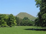
Thorpe is at the southern end of the Peak District National Park almost at the foot of Thorpe Cloud
, and is an excellent base for exploring Dovedale
and the Manifold Valley
.
The Dovedale Dash
, a 4¾ mile cross-country running race held annually each November, was first organised here in 1953.
It formerly had a railway station, Thorpe Cloud railway station
, served by the LNWR Ashbourne to Buxton
branch line, which linked with the Cromford and High Peak Railway
at Parsley Hay. This former trackbed now forms the long distance Tissington Trail
cycle and footpath trail. There is a small car park at the station site, and many walkers/cyclists leave the trail at this point to visit Dovedale
or the nearby picturesque village of Ilam
.
Civil parish
In England, a civil parish is a territorial designation and, where they are found, the lowest tier of local government below districts and counties...
in the English
England
England is a country that is part of the United Kingdom. It shares land borders with Scotland to the north and Wales to the west; the Irish Sea is to the north west, the Celtic Sea to the south west, with the North Sea to the east and the English Channel to the south separating it from continental...
county of Derbyshire
Derbyshire
Derbyshire is a county in the East Midlands of England. A substantial portion of the Peak District National Park lies within Derbyshire. The northern part of Derbyshire overlaps with the Pennines, a famous chain of hills and mountains. The county contains within its boundary of approx...
; it is on the Derbyshire/Staffordshire border, on the east bank of the River Dove
River Dove, Derbyshire
The River Dove is the principal river of the southwestern Peak District, in the Midlands of England and is around in length. It rises on Axe Edge Moor near Buxton and flows generally south to its confluence with the River Trent at Newton Solney. From there, its waters reach the North Sea via the...
, about four miles north of Ashbourne
Ashbourne, Derbyshire
Ashbourne is a small market town in the Derbyshire Dales, England. It has a population of 10,302.The town advertises itself as 'The Gateway to Dovedale'.- Local customs :...
.
Thorpe is at the southern end of the Peak District National Park almost at the foot of Thorpe Cloud
Thorpe Cloud
Thorpe Cloud is an isolated limestone hill lying between the villages of Thorpe and Ilam at the southern end of Dovedale. It is a popular hill amongst the many day-trippers who visit the area, and provides a fine viewpoint north up the dale and south across the Midland plain.Like much of the dale,...
, and is an excellent base for exploring Dovedale
Dovedale
Dovedale is a popular dale in the Peak District, England. It is owned by the National Trust, and annually attracts a million visitors. The valley is cut by the River Dove and runs for just over between Milldale in the north and a wooded ravine near Thorpe Cloud and Bunster Hill in the south...
and the Manifold Valley
River Manifold
The River Manifold is a river in Staffordshire, England. It is a tributary of the River Dove ....
.
The Dovedale Dash
Dovedale Dash
The Dovedale Dash is a 4¾ mile cross-country running race held annually along the banks of the River Dove, along Dovedale, and between the villages of Ilam and Thorpe in the Peak District, England....
, a 4¾ mile cross-country running race held annually each November, was first organised here in 1953.
It formerly had a railway station, Thorpe Cloud railway station
Thorpe Cloud railway station
Thorpe Cloud railway station was opened in 1899 between the villages of Thorpe and Fenny Bentley in Derbyshire, south east of Buxton.-History:...
, served by the LNWR Ashbourne to Buxton
Buxton
Buxton is a spa town in Derbyshire, England. It has the highest elevation of any market town in England. Located close to the county boundary with Cheshire to the west and Staffordshire to the south, Buxton is described as "the gateway to the Peak District National Park"...
branch line, which linked with the Cromford and High Peak Railway
Cromford and High Peak Railway
The Cromford and High Peak Railway in Derbyshire, England, was completed in 1831, to carry minerals and goods between the Cromford Canal wharf at High Peak Junction and the Peak Forest Canal at Whaley Bridge -Origins:...
at Parsley Hay. This former trackbed now forms the long distance Tissington Trail
Tissington Trail
right|thumb|200px|The Trail at the site of the former Tissington station, now a picnic site.The Tissington Trail is a bridleway and walk/cycle path in Derbyshire, England...
cycle and footpath trail. There is a small car park at the station site, and many walkers/cyclists leave the trail at this point to visit Dovedale
Dovedale
Dovedale is a popular dale in the Peak District, England. It is owned by the National Trust, and annually attracts a million visitors. The valley is cut by the River Dove and runs for just over between Milldale in the north and a wooded ravine near Thorpe Cloud and Bunster Hill in the south...
or the nearby picturesque village of Ilam
Ilam, Staffordshire
Ilam is a village in the Staffordshire Peak District, lying on the River Manifold. This article describes some of the main features of the village and surroundings.- Ilam village :...
.