

Ilam, Staffordshire
Encyclopedia
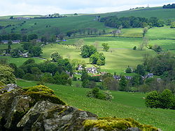
Village
A village is a clustered human settlement or community, larger than a hamlet with the population ranging from a few hundred to a few thousand , Though often located in rural areas, the term urban village is also applied to certain urban neighbourhoods, such as the West Village in Manhattan, New...
in the Staffordshire
Staffordshire
Staffordshire is a landlocked county in the West Midlands region of England. For Eurostat purposes, the county is a NUTS 3 region and is one of four counties or unitary districts that comprise the "Shropshire and Staffordshire" NUTS 2 region. Part of the National Forest lies within its borders...
Peak District
Peak District
The Peak District is an upland area in central and northern England, lying mainly in northern Derbyshire, but also covering parts of Cheshire, Greater Manchester, Staffordshire, and South and West Yorkshire....
, lying on the River Manifold
River Manifold
The River Manifold is a river in Staffordshire, England. It is a tributary of the River Dove ....
. This article describes some of the main features of the village and surroundings.
Ilam village
Ilam is best known as the location of the neo-Gothic Ilam Hall, a stately home built in the 1820s, and now a youth hostelYHA
YHA may refer to:* YHA Australia, a youth hostel association in Australia* Youth Hostels Association , a youth hostel charity in the United Kingdom* Youth Hostel Association of New Zealand, a youth hostel association in New Zealand...
owned by the National Trust
National Trust for Places of Historic Interest or Natural Beauty
The National Trust for Places of Historic Interest or Natural Beauty, usually known as the National Trust, is a conservation organisation in England, Wales and Northern Ireland...
. It is set in large parklands that are open to visitors.
Ilam is about 4 miles from Ashbourne
Ashbourne, Derbyshire
Ashbourne is a small market town in the Derbyshire Dales, England. It has a population of 10,302.The town advertises itself as 'The Gateway to Dovedale'.- Local customs :...
at the entrance to the scenic Manifold Valley. Ilam is very picturesque, with its "Swiss chalet
Chalet
A chalet , also called Swiss chalet, is a type of building or house, native to the Alpine region, made of wood, with a heavy, gently sloping roof with wide, well-supported eaves set at right angles to the front of the house.-Definition and origin:...
" style houses and matching school house. It also lies close to the popular Dovedale
Dovedale
Dovedale is a popular dale in the Peak District, England. It is owned by the National Trust, and annually attracts a million visitors. The valley is cut by the River Dove and runs for just over between Milldale in the north and a wooded ravine near Thorpe Cloud and Bunster Hill in the south...
valley.
While most of the buildings in the village are from the past two centuries, Ilam dates from Saxon times or earlier.
Recently the village has attracted praise for its commitment to eco- friendly
Environmentally friendly
Environmentally friendly are terms used to refer to goods and services, laws, guidelines and policies claimed to inflict minimal or no harm on the environment....
policies. Ilam became the first community in the United Kingdom to phase out incandescent light bulb
Incandescent light bulb
The incandescent light bulb, incandescent lamp or incandescent light globe makes light by heating a metal filament wire to a high temperature until it glows. The hot filament is protected from air by a glass bulb that is filled with inert gas or evacuated. In a halogen lamp, a chemical process...
s, cutting annual carbon emissions by 4 tonnes. The initiative was part of the Ilam Climate Change Project, supported by the Marches Energy Agency.
Geography
Ilam is situated in the Manifold Valley near the southern end where it joins the River Dove. The Dove forms the county boundary between StaffordshireStaffordshire
Staffordshire is a landlocked county in the West Midlands region of England. For Eurostat purposes, the county is a NUTS 3 region and is one of four counties or unitary districts that comprise the "Shropshire and Staffordshire" NUTS 2 region. Part of the National Forest lies within its borders...
and Derbyshire
Derbyshire
Derbyshire is a county in the East Midlands of England. A substantial portion of the Peak District National Park lies within Derbyshire. The northern part of Derbyshire overlaps with the Pennines, a famous chain of hills and mountains. The county contains within its boundary of approx...
. Upstream from Ilam is the famous Dovedale
Dovedale
Dovedale is a popular dale in the Peak District, England. It is owned by the National Trust, and annually attracts a million visitors. The valley is cut by the River Dove and runs for just over between Milldale in the north and a wooded ravine near Thorpe Cloud and Bunster Hill in the south...
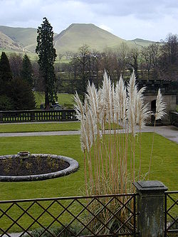
walk to Milldale. At the Ilam end, the walk crosses the Dove on a famous line of stepping stones. A wide and picturesque curve of the Manifold provides an ideal setting for Ilam Hall.
River Manifold
The River Manifold flows underground from Wetton Mill, and rises again at Ilam in the grounds of the hall. At some times of the year, the river bed is completely dry apart from the occasional pool. The River HampsRiver Hamps
The River Hamps is a river in Staffordshire, England. It is tributary of the River Manifold, which itself flows into the River Dove near Ilam. For its entire length the river flows through the Peak District National Park.- Etymology :...
is a tributary of the Manifold which also flows underground leaving a dry river bed. At Ilam Hall, the Manifold rises a few yards downstream from a local spring. During certain weather conditions, when muddy water flows upstream of Wetton Mill, there is a clear difference between the clear water from the spring, and the muddy water rising just downstream.
Ilam Hall
See Ilam ParkIlam Park
Ilam Park is a country park situated in Ilam, on both banks of the River Manifold five miles north west of Ashbourne, England, and in the ownership of the National Trust...
A hall has been here since John Port had the first one built in 1546. Both William Congreve
William Congreve
William Congreve was an English playwright and poet.-Early life:Congreve was born in Bardsey, West Yorkshire, England . His parents were William Congreve and his wife, Mary ; a sister was buried in London in 1672...
and Dr Samuel Johnson
Samuel Johnson
Samuel Johnson , often referred to as Dr. Johnson, was an English author who made lasting contributions to English literature as a poet, essayist, moralist, literary critic, biographer, editor and lexicographer...
stayed at the hall when it was owned by the Port family. Congreve wrote his first play, The Old Bachelor here and Paradise valley inspired Johnson to write his novel Rasselas.
In 1820 the estate was bought by Jesse Watts-Russell, a wealthy industrialist. It was Watts-Russell who was responsible for the Swiss look of Ilam; he found that the valley and surrounding hills reminded him of the Alps, and consequently had some new cottages built in the Swiss style and rehoused most of the villagers (who were living in estate-owned houses anyway). He also built the school in 1857 and funded it, at a time when schooling was not compulsory.
His son, John Charles Watts-Russell
John Charles Watts-Russell
John Charles Watts-Russell JP was a 19th century New Zealand politician, a member of the Canterbury Provincial Council and a member of the Legislative Council. He was supposedly the wealthiest of the early settlers, and his homestead became the centre of entertainment in Christchurch...
, moved to New Zealand and built another Ilam Hall. The farm/homestead that he created later grew and became the Ilam area
Ilam, New Zealand
Ilam is a leafy suburb of Christchurch, New Zealand about five kilometres west of the city centre. It is the location of the University of Canterbury....
of Christchurch
Christchurch
Christchurch is the largest city in the South Island of New Zealand, and the country's second-largest urban area after Auckland. It lies one third of the way down the South Island's east coast, just north of Banks Peninsula which itself, since 2006, lies within the formal limits of...
. The site of the homestead was one of the main social centres of early Christchurch society. The present homestead was built in 1914 after fire destroyed the first two buildings.
The Conservative politician Robert William Hanbury
Robert William Hanbury
Robert William Hanbury PC was a British Conservative politician. He served as President of the Board of Agriculture from 1900 to 1903.-Background and education:...
(1845–1903), lived and was buried here.
In 1934 Sir Robert McDougal bought the hall and gave it to the National Trust
National Trust for Places of Historic Interest or Natural Beauty
The National Trust for Places of Historic Interest or Natural Beauty, usually known as the National Trust, is a conservation organisation in England, Wales and Northern Ireland...
to become a Youth Hostel and it is still run as such today. The grounds are open to the public, and are a starting point for one of the prettiest river walks in the area.
The Church of the Holy Cross
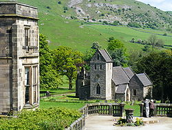
Some of its Saxon origins can be seen in its carved stone Saxon font, and in two stone cross shafts in the churchyard. Arthur Mee records that the Church was restored
Victorian restoration
Victorian restoration is the term commonly used to refer to the widespread and extensive refurbishment and rebuilding of Church of England churches and cathedrals that took place in England and Wales during the 19th-century reign of Queen Victoria...
in the 19th century by Sir Gilbert Scott
Gilbert Scott
Gilbert Scott may refer to several of a family of British architects:* Sir George Gilbert Scott , who was principally known for his architectural designs for the Foreign and Commonwealth Office and St Pancras Station...
, with three chapels, but "still has the 13th century base of its tower, and a wall of the same age. Its most ancient jewel is the wonderful font, so old that it is Saxon or Norman, the round bowl carved with humans and dragons."
It is in the Chapel of St Bertram, built in 1618 by the Meverell, Port and Hurt families, that the remains and shrine of the St Bertam
St Bertelin
Beorhthelm is an Anglo-Saxon saint about whom the only evidence is legendary. He is said to have had a hermitage on the island of Bethnei, which later became the town of Stafford. Later he went to a more hilly area, possibly near Ilam, where he died. His shrine is in the Church of the Holy...
(or Bertelin) can be found. St Bertam was a 8th Century son of a Mercian king who renounced his royal heritage for prayer and meditation after his wife and child were killed by wolves. He is said to have converted many to Christianity, and his shrine became a point of pilgrimage in the Middle Ages, it being reputed to be able to work miraculous cures.
Dovedale House
This is a large old house near the entrance of Ilam Hall. It used to be the vicarage and is now run as a residential Youth centre. Owned by the Church of England, it is under the management of the Diocese of Lichfield. It was opened as a residential centre in 1967.School
The village primary school is still open and serves quite a wide area because schools as far afield as Alstonfield have closed. (Children travel to secondary schools at AshbourneAshbourne, Derbyshire
Ashbourne is a small market town in the Derbyshire Dales, England. It has a population of 10,302.The town advertises itself as 'The Gateway to Dovedale'.- Local customs :...
, Warslow
Warslow
Warslow is a small village in Staffordshire, England. It is located in the Peak District National Park about north of Ashbourne.Although in the county of Staffordshire, the village lies close to the Derbyshire border, and in fact has a Derbyshire postal address, i.e...
or Leek
Leek, Staffordshire
Leek is a market town in the county of Staffordshire, England, on the River Churnet. It is an ancient borough and was granted its royal charter in 1214.It is the administrative centre for the Staffordshire Moorlands District Council...
.)
Village Cross
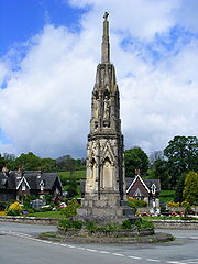
Blore
Blore is a small village and parish in the Staffordshire Moorlands District of England.It is on an acclivity above Dovedale, three and a half miles north west of Ashbourne, including the hamlet of Swinscoe, one mile to the south and a part of the parochial chapelry of Calton.The ecclesiastical...
, this is an ornate gothic-style obelisk of local limestone. Standing on a three step plinth, it has two tiers of statues surmounted by a spire with a cross at the top. In style, it bears some resemblance to the decorated facade of Lichfield Cathedral.
Being sandstone, the Cross is crumbling severely. There is now (notice viewed May 2009) a proposal for restoration. Meanwhile, the top has been netted to catch any falling pieces, but fragments are still falling from the lower sections.
Manifold Valley Agricultural Show
The Manifold Valley Agricultural Show has for a number of years been held within the parish. This show has usually been held on the second Saturday of August. The wide range of categories and activities provides a valuable social focus for this largely agricultural area. 2009 saw the 30th Annual Agricultural Show, held on Saturday 8 August. The venue is farmland owned by and above Casterne Hall just under a mile north of the village, on the plateau about half way towards Stanshope. The road continues towards WettonWetton, Staffordshire
Wetton is a village in the Peak District National Park, North Staffordshire, at the top of the east side of the Manifold Valley. The population recorded in the 2001 Census was 157. This article describes the location, some of the main features of the village, and a number of places of historical or...
and Alstonefield
Alstonefield
Alstonefield is a village and civil parish in the Peak District National Park and the Staffordshire Moorlands district of Staffordshire, England. It is about to the North of Ashbourne, drive East from Leek and south from Buxton...
.