
Theodore, Australian Capital Territory
Encyclopedia
- TheodoreTheodore, QueenslandTheodore is a town in Queensland, Australia, situated on the Dawson River. The town - like the Canberra suburb - is named in honour of Labor politician Ted Theodore, Premier of Queensland and Treasurer of Australia in the ministry of Prime Minister James Scullin...
is also the name of a town in QueenslandQueenslandQueensland is a state of Australia, occupying the north-eastern section of the mainland continent. It is bordered by the Northern Territory, South Australia and New South Wales to the west, south-west and south respectively. To the east, Queensland is bordered by the Coral Sea and Pacific Ocean...
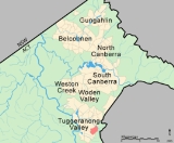
Theodore is a suburb in the Canberra
Canberra
Canberra is the capital city of Australia. With a population of over 345,000, it is Australia's largest inland city and the eighth-largest city overall. The city is located at the northern end of the Australian Capital Territory , south-west of Sydney, and north-east of Melbourne...
, Australia
Australia
Australia , officially the Commonwealth of Australia, is a country in the Southern Hemisphere comprising the mainland of the Australian continent, the island of Tasmania, and numerous smaller islands in the Indian and Pacific Oceans. It is the world's sixth-largest country by total area...
district of Tuggeranong
Tuggeranong
Tuggeranong is the southernmost town centre of Canberra, the capital city of Australia. It comprises 19 suburbs with a total of 31,819 dwellings, housing 87,119 people of the 324,034 people in the Australian Capital Territory . The district occupies 117 square kilometres to the east of the...
. The postcode is 2905. The suburb is named after Edward Glanville Theodore
Ted Theodore
Edward Granville Theodore was an Australian politician. He was Premier of Queensland 1919–25, a federal politician representing a New South Wales seat 1927–31, and Federal Treasurer 1929–30.-Early life:...
(1884–1950), a Queensland
Queensland
Queensland is a state of Australia, occupying the north-eastern section of the mainland continent. It is bordered by the Northern Territory, South Australia and New South Wales to the west, south-west and south respectively. To the east, Queensland is bordered by the Coral Sea and Pacific Ocean...
premier and deputy Prime Minister. It was gazetted on 5 August 1975. Streets are named after people involved with the civilian war effort during the world wars. The main street through the suburb is named after Sir Lawrence Wackett
Lawrence Wackett
Sir Lawrence James Wackett KBE, DFC, AFC is widely regarded as "father of the Australian aircraft industry". He has been described as "one of the towering figures in the history of Australian aviation covering, as he did, virtually all aspects of activities: pilot, designer of airframes and...
KBE, DFC, AFC
Air Force Cross (United Kingdom)
The Air Force Cross is a military decoration awarded to personnel of the United Kingdom Armed Forces, and formerly also to officers of the other Commonwealth countries, for "an act or acts of valour, courage or devotion to duty whilst flying, though not in active operations against the enemy"...
, who is widely regarded as the "father of the Australian aircraft industry".
On Census night 2006, Theodore had a population of 4,109 people., and had a median age of 30 compared to the Australian median age of 37.
It is next to the suburbs of Conder
Conder, Australian Capital Territory
Conder is one of three suburbs in the Lanyon Valley in Canberra, Australia. It lies in the district of Tuggeranong. The three suburbs are presently the southernmost suburbs of the city, although the small settlement of Tharwa exists only a short distance further south.Named after artist Charles...
and Calwell
Calwell, Australian Capital Territory
Calwell is a medium sized suburb of Canberra, Australia in the district of Tuggeranong. Tuggeranong Hill is on its southern border and the Tuggeranong Homestead is to the north...
. It is bounded by the Monaro Highway
Monaro Highway
The Monaro Highway is a state highway in New South Wales, the Australian Capital Territory and Victoria, Australia. The Victorian section was formerly known as the Cann Valley Highway until the 1980s....
and Tharwa drive. Located in the suburb is Theodore Primary School and a neighbourhood oval. It borders on Tuggeranong Hill
Tuggeranong Hill
Tuggeranong Hill is located in Tuggeranong, Canberra. It is sometimes referred to as Mount Tuggeranong due to its prominence.Lanyon Valley is almost completely surrounded by hills and mountains and consequently television transmissions from Black Mountain are affected. To overcome this, there is a...
and the Canberra Nature Park
Canberra Nature Park
The Canberra Nature Park is actually 30 separate protected areas in Canberra, Australian Capital Territory, ranging from bushland hills to lowland native grassland...
of Tuggeranong Hill nature reserve.
Geology
Silurian
The Silurian is a geologic period and system that extends from the end of the Ordovician Period, about 443.7 ± 1.5 Mya , to the beginning of the Devonian Period, about 416.0 ± 2.8 Mya . As with other geologic periods, the rock beds that define the period's start and end are well identified, but the...
age 414 Mya.
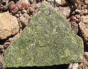
Deakin Volcanics Rhyodacite
Rhyodacite
Rhyodacite is an extrusive volcanic rock intermediate in composition between dacite and rhyolite. It is the extrusive equivalent of granodiorite. Phenocrysts of sodium rich plagioclase, sanidine, quartz, and biotite or hornblende are typically set in an aphanitic to glassy light to intermediate...
and sediment
Sediment
Sediment is naturally occurring material that is broken down by processes of weathering and erosion, and is subsequently transported by the action of fluids such as wind, water, or ice, and/or by the force of gravity acting on the particle itself....
s are in the east.
Deakin Volcanics red-purple and green grey rhyodacite are in the center.
Deakin Volcanics green grey and purple rhyodacite are in the west.
Deakin Volcanics cream rhyolite
Rhyolite
This page is about a volcanic rock. For the ghost town see Rhyolite, Nevada, and for the satellite system, see Rhyolite/Aquacade.Rhyolite is an igneous, volcanic rock, of felsic composition . It may have any texture from glassy to aphanitic to porphyritic...
is in high south east parts.
Quaternary
Quaternary
The Quaternary Period is the most recent of the three periods of the Cenozoic Era in the geologic time scale of the ICS. It follows the Neogene Period, spanning 2.588 ± 0.005 million years ago to the present...
alluvium
Alluvium
Alluvium is loose, unconsolidated soil or sediments, eroded, deposited, and reshaped by water in some form in a non-marine setting. Alluvium is typically made up of a variety of materials, including fine particles of silt and clay and larger particles of sand and gravel...
is in the north lower parts, washed off the surrounding slopes.