
Calwell, Australian Capital Territory
Encyclopedia
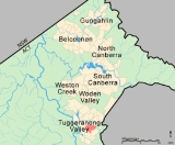
Calwell is a medium sized suburb of Canberra
, Australia
in the district of Tuggeranong
. Tuggeranong Hill
is on its southern border and the Tuggeranong Homestead
is to the north. Calwell is located close to the Monaro Highway
which provides a direct route to Canberra City and to Cooma
.
 The suburb was named after the Labor politician, Arthur Augustus Calwell, PC (1896-1973)
. The suburb name was gazetted 5 August 1975. Streets in the suburb are named for Victorian politicians. Outtrim Avenue between Johnson Drvie and the Calwell Shopping Centre is named after Alfred Richard Outtrim
who represented Maryborough
from 1885 to 1920.
, Theodore
and Isabella Plains
. Prior to the development of the Lanyon Market Place
in the late 1990s, the Calwell Centre also serviced Conder
, Banks
and Gordon
. Among the retail and service outlets are a Woolworths supermarket, Caltex Woolworths service station
, tavern
, Chinese restaurant
, car wash and several other businesses.
The Calwell Club opened in 2004 and is located adjacent to the centre.
, runs services in the hall at St Francis of Assisi Primary School.
bus routes. On weekdays, routes 11 and 67 operate between Tuggeranong
Interchange and Woden
Interchange. Route 11 operates every 30 minutes until 6pm and hourly from 6pm to 11.30pm and route 67 operates hourly. During peak periods
route 111 replaces route 11 which extends the route from Woden Interchange to the City Interchange; route 267 replaces route 67 and extends the route from Woden Interchange to the Parliamentary Triangle
and the City. Routes 768 and 769 also provide a peak period service between Calwell, Kingston
, the Parliamentary Triangle and the City. On weekends and public holidays routes 912 and 915 provide a service between Tuggeranong Interchange and Calwell.
All Canberra taxi companies and Queanbeyan taxis also service Calwell.
of Silurian
age form the base rock of Calwell.
Canberra
Canberra is the capital city of Australia. With a population of over 345,000, it is Australia's largest inland city and the eighth-largest city overall. The city is located at the northern end of the Australian Capital Territory , south-west of Sydney, and north-east of Melbourne...
, Australia
Australia
Australia , officially the Commonwealth of Australia, is a country in the Southern Hemisphere comprising the mainland of the Australian continent, the island of Tasmania, and numerous smaller islands in the Indian and Pacific Oceans. It is the world's sixth-largest country by total area...
in the district of Tuggeranong
Tuggeranong
Tuggeranong is the southernmost town centre of Canberra, the capital city of Australia. It comprises 19 suburbs with a total of 31,819 dwellings, housing 87,119 people of the 324,034 people in the Australian Capital Territory . The district occupies 117 square kilometres to the east of the...
. Tuggeranong Hill
Tuggeranong Hill
Tuggeranong Hill is located in Tuggeranong, Canberra. It is sometimes referred to as Mount Tuggeranong due to its prominence.Lanyon Valley is almost completely surrounded by hills and mountains and consequently television transmissions from Black Mountain are affected. To overcome this, there is a...
is on its southern border and the Tuggeranong Homestead
Tuggeranong Homestead
Tuggeranong Homestead is located in the Australian Capital Territory in the area now covered by the suburb of Richardson.The first authorised landowner of the Tuggeranong area following white settlement was Peter Murdoch, aide-de-camp of Thomas Brisbane, who was awarded a grant of 2,000 acres in...
is to the north. Calwell is located close to the Monaro Highway
Monaro Highway
The Monaro Highway is a state highway in New South Wales, the Australian Capital Territory and Victoria, Australia. The Victorian section was formerly known as the Cann Valley Highway until the 1980s....
which provides a direct route to Canberra City and to Cooma
Cooma, New South Wales
-Education: is Cooma's only public high school, it serves the town and seven of the neighbouring rural towns and villages such as Berridale, Jindabyne, Nimmitabel, Bredbo and Dalgety....
.
History
Arthur Calwell
Arthur Augustus Calwell Australian politician, was a member of the Australian House of Representatives for 32 years from 1940 to 1972, Immigration Minister in the government of Ben Chifley from 1945 to 1949 and Leader of the Australian Labor Party from 1960 to 1967.-Early life:Calwell was born in...
. The suburb name was gazetted 5 August 1975. Streets in the suburb are named for Victorian politicians. Outtrim Avenue between Johnson Drvie and the Calwell Shopping Centre is named after Alfred Richard Outtrim
Alfred Richard Outtrim
Alfred Richard Outtrim was a long serving Victorian politician who gained a reputation as a competent government minister a promoter of women's suffrage and regional development....
who represented Maryborough
Maryborough, Victoria
-Education:Maryborough has three schools:*Highview Christian Community College*Maryborough Education Centre Years Prep–12*St Augustine's Primary School Grades Prep–6-Music:...
from 1885 to 1920.
Calwell Centre
The Calwell Centre is a designated group centre located on Webber Crescent in the north of the suburb. The centre was developed in the early 1990s to serve Calwell, RichardsonRichardson, Australian Capital Territory
Richardson is a suburb in the Canberra, Australia, district of Tuggeranong. The postcode is 2905. The suburb is named after the author Henry Handel Richardson, nom de plume of Ethel Florence Lindesay Richardson . It was gazetted on 5 May 1975. Streets are named after writers, especially female...
, Theodore
Theodore, Australian Capital Territory
Theodore is a suburb in the Canberra, Australia district of Tuggeranong. The postcode is 2905. The suburb is named after Edward Glanville Theodore , a Queensland premier and deputy Prime Minister. It was gazetted on 5 August 1975. Streets are named after people involved with the civilian war...
and Isabella Plains
Isabella Plains, Australian Capital Territory
Isabella Plains is a suburb in the Canberra, Australia district of Tuggeranong. The postcode is 2905. The suburb is indirectly named after Isabella Maria Brisbane , who was the daughter of Thomas Brisbane the colonial Governor of New South Wales when the area was first explored by white settlers...
. Prior to the development of the Lanyon Market Place
Lanyon Market Place
Lanyon Marketplace is a group centre in district of Tuggeranong in the city of Canberra. The centre primarily services the Lanyon Valley at the southern end of Tuggeranong, consisting of the suburbs of Conder, Gordon and Banks; the centre also services other suburbs to the north and Tharwa to the...
in the late 1990s, the Calwell Centre also serviced Conder
Conder, Australian Capital Territory
Conder is one of three suburbs in the Lanyon Valley in Canberra, Australia. It lies in the district of Tuggeranong. The three suburbs are presently the southernmost suburbs of the city, although the small settlement of Tharwa exists only a short distance further south.Named after artist Charles...
, Banks
Banks, Australian Capital Territory
Banks is a suburb in the Canberra, Australia district of Tuggeranong. It is the most southerly suburb of Canberra. The suburb is named after Sir Joseph Banks , the botanist who accompanied Captain James Cook to the Pacific Ocean on which he entered Botany Bay in 1770. The suburb was gazetted on 12...
and Gordon
Gordon, Australian Capital Territory
Gordon is a suburb in the Canberra, Australia district of Tuggeranong. The postcode is 2906. The suburb is named after the poet Adam Lindsay Gordon . It was gazetted on 12 March 1987...
. Among the retail and service outlets are a Woolworths supermarket, Caltex Woolworths service station
Filling station
A filling station, also known as a fueling station, garage, gasbar , gas station , petrol bunk , petrol pump , petrol garage, petrol kiosk , petrol station "'servo"' in Australia or service station, is a facility which sells fuel and lubricants...
, tavern
Tavern
A tavern is a place of business where people gather to drink alcoholic beverages and be served food, and in some cases, where travelers receive lodging....
, Chinese restaurant
Restaurant
A restaurant is an establishment which prepares and serves food and drink to customers in return for money. Meals are generally served and eaten on premises, but many restaurants also offer take-out and food delivery services...
, car wash and several other businesses.
The Calwell Club opened in 2004 and is located adjacent to the centre.
Government schools
- Calwell High School, located on Casey Crescent, opened in 1990 and caters for students in Years 7 to 10.
- Calwell Primary School, located on Downard Street, opened in 1989 and caters for students From Pre School to Year 6.
Non-government schools
- St Francis of Assisi Primary School, located on Casey Crescent, is a Catholic school that began operating from Holy Family School, Gowrie in 1988 and caters for students in Kindergarten to Year 6.
Churches
St Mary in the Valley Anglican Parish Centre is located on the corner of Were Street and Webber Crescent; in addition to Church services the Parish also manages the Calwell Community Centre. Alliance Church Tuggeranong is also located on Were Street. Corpus Christi Catholic Parish, based in GowrieGowrie, Australian Capital Territory
Gowrie is a suburb of Canberra, Australia, located in the northern end of the Tuggeranong Valley. Tuggeranong suburbs are the southernmost of Australia's capital city...
, runs services in the hall at St Francis of Assisi Primary School.
Transport
Calwell is serviced by several ACTIONACTION
ACTION is a public bus service operating in Canberra, ACT, Australia. It is operated by the ACT Department of Territory and Municipal Services...
bus routes. On weekdays, routes 11 and 67 operate between Tuggeranong
Tuggeranong Town Centre
Tuggeranong Town Centre services the southernmost Canberra district of Tuggeranong. It is located on the south-western side of Lake Tuggeranong and composed of a large three-storey mall, the Tuggeranong Hyperdome, as well as a smaller shopping complex, the Homeworld, and many other buildings and...
Interchange and Woden
Woden Town Centre
Woden Town Centre is the main commercial centre of the district of Woden Valley in Canberra, Australia. It is located in the Canberra suburb of Phillip....
Interchange. Route 11 operates every 30 minutes until 6pm and hourly from 6pm to 11.30pm and route 67 operates hourly. During peak periods
Rush hour
A rush hour or peak hour is a part of the day during which traffic congestion on roads and crowding on public transport is at its highest. Normally, this happens twice a day—once in the morning and once in the evening, the times during when the most people commute...
route 111 replaces route 11 which extends the route from Woden Interchange to the City Interchange; route 267 replaces route 67 and extends the route from Woden Interchange to the Parliamentary Triangle
Parliamentary Triangle, Canberra
The Parliamentary Triangle is the ceremonial precinct of Canberra, containing some of Australia's most significant buildings. The triangle is formed by Commonwealth, Kings and Constitution avenues...
and the City. Routes 768 and 769 also provide a peak period service between Calwell, Kingston
Kingston, Australian Capital Territory
Kingston is the oldest and most densely populated suburb of Canberra, Australian Capital Territory, Australia. The suburb is named after Charles Cameron Kingston, the former Premier of South Australia and minister in the first Australian Commonwealth Government. It is adjacent to the suburbs of...
, the Parliamentary Triangle and the City. On weekends and public holidays routes 912 and 915 provide a service between Tuggeranong Interchange and Calwell.
All Canberra taxi companies and Queanbeyan taxis also service Calwell.
Geology
Deakin Volcanics green grey and purple rhyodaciteRhyodacite
Rhyodacite is an extrusive volcanic rock intermediate in composition between dacite and rhyolite. It is the extrusive equivalent of granodiorite. Phenocrysts of sodium rich plagioclase, sanidine, quartz, and biotite or hornblende are typically set in an aphanitic to glassy light to intermediate...
of Silurian
Silurian
The Silurian is a geologic period and system that extends from the end of the Ordovician Period, about 443.7 ± 1.5 Mya , to the beginning of the Devonian Period, about 416.0 ± 2.8 Mya . As with other geologic periods, the rock beds that define the period's start and end are well identified, but the...
age form the base rock of Calwell.