
The Sow of Atholl
Encyclopedia
Scotland
Scotland is a country that is part of the United Kingdom. Occupying the northern third of the island of Great Britain, it shares a border with England to the south and is bounded by the North Sea to the east, the Atlantic Ocean to the north and west, and the North Channel and Irish Sea to the...
hill which is situated 27 kilometres WNW of the town of Blair Atholl
Blair Atholl
Blair Atholl is a small town in Perthshire, Scotland, built about the confluence of the Rivers Tilt and Garry in one of the few areas of flat land in the midst of the Grampian Mountains. The Gaelic place-name Blair, from blàr, 'field, plain', refers to this location...
in Perth and Kinross
Perth and Kinross
Perth and Kinross is one of 32 council areas in Scotland, and a Lieutenancy Area. It borders onto the Aberdeenshire, Angus, Dundee City, Fife, Clackmannanshire, Stirling, Argyll and Bute and Highland council areas. Perth is the administrative centre...
council area. It stands on the western side of the Pass of Drumochter
Pass of Drumochter
The Pass of Drumochter is the main mountain pass between the northern and southern central Scottish Highlands. The A9 road passes through here, as does the Highland Main Line, the railway between Inverness and the south of Scotland...
in a group of hills which lie around Coire Dhomhain.
Overview
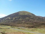
The Sow is a steep conical hill which reaches a height of 803 metres (2634 feet) it qualifies as a Corbett and a MarilynMarilyn (hill)
A Marilyn is a mountain or hill in the United Kingdom, Republic of Ireland or Isle of Man with a relative height of at least 150 metres , regardless of absolute height or other merit...
. It throws down its least precipitous slopes to the SE in a broad ridge to Dalnaspidal Lodge from where the hill is often climbed. It stands immediately next to the A9 and the Highland Main Line
Highland Main Line
The Highland Main Line is a railway line in Scotland. It is long and runs through the Scottish Highlands linking a series of small towns and villages with Perth at one end and Inverness at the other. Today, services between Inverness and Edinburgh, Glasgow and London use the line...
as they pass the highest point of the Drumochter Pass and the hill is well seen from the road and railway. The hill's strange Anglicised
Anglicisation
Anglicisation, or anglicization , is the process of converting verbal or written elements of any other language into a form that is more comprehensible to an English speaker, or, more generally, of altering something such that it becomes English in form or character.The term most often refers to...
name is believed to be a “more recent and fanciful name”, a response to match the hill known as the Boar of Badenoch which lies 2.5 km to the north. Its more ancient and correct name is Meall an Dobharchain which translates from the Scottish Gaelic as Watercress Hill and this refers to the marshy ground on the lower SE flanks of the hill where watercress
Watercress
Watercresses are fast-growing, aquatic or semi-aquatic, perennial plants native from Europe to central Asia, and one of the oldest known leaf vegetables consumed by human beings...
would have grown in the past. Although Watercress Hill is the accepted translation today, in 1854 The New Statistical Account Of Scotland referred to the hill as Carnan Dóbhrain which can be translated as Small Cairn of the Otters.
Geography
The Sow of Atholl is not a hill rich in geographical highlights, its steep slopes are covered in heatherCalluna
Calluna vulgaris is the sole species in the genus Calluna in the family Ericaceae. It is a low-growing perennial shrub growing to tall, or rarely to and taller, and is found widely in Europe and Asia Minor on acidic soils in open sunny situations and in moderate shade...
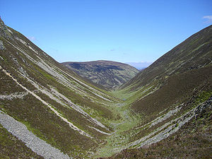
interspersed with grass and the occasional boulder. Its one noteworthy feature is the steep valley to the west of the hill which prevents a straight forward walk to the adjoining Munro of Sgairneach Mhòr
Sgairneach Mhòr
Sgairneach Mhòr is a Scottish mountain which lies in a group of seven Munros near the summit of the Pass of Drumochter and are known as the Drumochter mountains or informerly as the “A9 Munros”...
which lies three km to the SW. The nameless steep glen has been cited as a fine example of a Parabolic
Parabola
In mathematics, the parabola is a conic section, the intersection of a right circular conical surface and a plane parallel to a generating straight line of that surface...
glacial
Glacier
A glacier is a large persistent body of ice that forms where the accumulation of snow exceeds its ablation over many years, often centuries. At least 0.1 km² in area and 50 m thick, but often much larger, a glacier slowly deforms and flows due to stresses induced by its weight...
valley. It drops 200 metres from the summit plateau of the Sow in a short distance and although the slopes are not unmanageable for a walker, most will contour round the head of the valley when traversing between The Sow and Sgairneach Mhòr rather than take a direct route. The presence of this steep valley gives The Sow its required prominence to give it the status of a separate mountain. All rainfall on the hill goes south to join the drainage basin
Drainage basin
A drainage basin is an extent or an area of land where surface water from rain and melting snow or ice converges to a single point, usually the exit of the basin, where the waters join another waterbody, such as a river, lake, reservoir, estuary, wetland, sea, or ocean...
of the River Tay
River Tay
The River Tay is the longest river in Scotland and the seventh-longest in the United Kingdom. The Tay originates in western Scotland on the slopes of Ben Lui , then flows easterly across the Highlands, through Loch Dochhart, Loch Lubhair and Loch Tay, then continues east through Strathtay , in...
and reaches the east coast of Scotland at the Firth of Tay
Firth of Tay
The Firth of Tay is a firth in Scotland between the council areas of Fife, Perth and Kinross, the City of Dundee and Angus, into which Scotland's largest river in terms of flow, the River Tay, empties....
.
Biology
The Sow has several interesting biological specimens on its surface. MenziesiaMenziesia
Menziesia is a genus of flowering plant in the family Ericaceae.Species include:* Menziesia ciliicalyx* Menziesia ferruginea - False azalea or Fool's huckleberry* Menziesia multiflora...
Caerulea, (Norwegian blue heather) is to be found growing on its slopes, this is a subarctic
Subarctic
The Subarctic is a region in the Northern Hemisphere immediately south of the true Arctic and covering much of Alaska, Canada, the north of Scandinavia, Siberia, and northern Mongolia...
plant which requires steep, partially stabilised block scree
Scree
Scree, also called talus, is a term given to an accumulation of broken rock fragments at the base of crags, mountain cliffs, or valley shoulders. Landforms associated with these materials are sometimes called scree slopes or talus piles...
slopes and peat
Peat
Peat is an accumulation of partially decayed vegetation matter or histosol. Peat forms in wetland bogs, moors, muskegs, pocosins, mires, and peat swamp forests. Peat is harvested as an important source of fuel in certain parts of the world...
y soil. At one time The Sow of Atholl was thought to be only site in the British Isles
British Isles
The British Isles are a group of islands off the northwest coast of continental Europe that include the islands of Great Britain and Ireland and over six thousand smaller isles. There are two sovereign states located on the islands: the United Kingdom of Great Britain and Northern Ireland and...
where Menziesia Caerulea grew but it has now been located growing in the Ben Alder
Ben Alder
Ben Alder is the highest mountain in the remote area of the Scottish Highlands between Loch Ericht and Glen Spean. The vast summit plateau is home of one of Britain's highest bodies of standing water, Lochan a' Garbh Coire. It is the 25th highest Munro, and due to its remote location, one of the...
range as well. Other plants native to subarctic regions such as Cornus suecica
Cornus suecica
Cornus suecica is a species of flowering plant in the genus Cornus , native to cool temperate and subarctic regions of Europe and Asia, and also locally in extreme northeastern and northwestern North America.These plants are herbaceous perennials growing to 5–15 cm tall, with few pairs of...
(Eurasian Dwarf Cornel) and Sibbaldia procumbens http://www.swcoloradowildflowers.com/Yellow%20Enlarged%20Photo%20Pages/sibbaldia%20procumbens.htm are to be found on the hill.
Ascents and view
The Sow of Atholl is climbed directly from the A9 road and with a starting altitude of around 400 metres it is not a hard climb. The most popular point to commence a direct ascent is Dalnaspidal Lodge where there is lay-by parking. The flat area around the lodge is quite boggy and is prone to flooding after wet weather due to presence of a sluice dam. The route goes straight up the SE flanks of the hill which are its least steep. The start at Dalnaspidal gives the opportunity to climb The Sow along with the Corbett Meall na Leitreach which lies five km to the south across Loch Garry. Another possible starting point is 2.5 km further north on the A9 at the summit of the Pass of Drumochter although the climb from here is steeper. The Sow can be climbed as part of a round of Coire Dhomhain, taking in the other Munros of Sgairneach Mhòr, Beinn UdlamainBeinn Udlamain
Beinn Udlamain is a Scottish mountain which stands just to the west of the summit of the Pass of Drumochter and east of Loch Ericht, some 30 km west-northwest of the village of Blair Atholl. The mountain’s summit stands on the border between the Highland and Perth and Kinross council...
and A' Mharconaich
A' Mharconaich
A' Mharconaich is a Scottish mountain that is located 29 km WNW of Blair Atholl in the Highland council area. It is in a group of mountains that lie west of the A9 road near the summit of the Pass of Drumochter and are known accordingly as the Drumochter Hills...
. The top of the hill is marked by a small cairn
Cairn
Cairn is a term used mainly in the English-speaking world for a man-made pile of stones. It comes from the or . Cairns are found all over the world in uplands, on moorland, on mountaintops, near waterways and on sea cliffs, and also in barren desert and tundra areas...
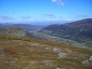
made up of a few rocks. The highlight of the view is a fine prospect both north and south down the Pass of Drumochter..