

The Narrows (Zion National Park)
Encyclopedia
Zion National Park
Zion National Park is located in the Southwestern United States, near Springdale, Utah. A prominent feature of the park is Zion Canyon, which is 15 miles long and up to half a mile deep, cut through the reddish and tan-colored Navajo Sandstone by the North Fork of the Virgin River...
, (near Springdale, Utah
Springdale, Utah
Springdale is a town in Washington County, Utah, United States. The population was 457 at the 2000 census. It is located immediately outside the boundaries of Zion National Park, and is oriented around the resulting tourist industry. It was originally settled as a Mormon farming community in 1862...
) is a section of canyon on the North Fork of the Virgin River
Virgin River
The Virgin River is a tributary of the Colorado River in the U.S. states of Utah, Nevada, and Arizona. The river is about long. It was designated Utah's first wild and scenic river in 2009, during the centennial celebration of Zion National Park.-Course:...
. The hike of The Narrows is one of the premier hikes on the Colorado Plateau
Colorado Plateau
The Colorado Plateau, also called the Colorado Plateau Province, is a physiographic region of the Intermontane Plateaus, roughly centered on the Four Corners region of the southwestern United States. The province covers an area of 337,000 km2 within western Colorado, northwestern New Mexico,...
. The term The Narrows refers to both the through-hike of The Narrows, and to The Narrows themselves, especially the 3.6 mile (6 km) long section of canyon between the end of the Riverside Walk Trail and Big Springs. The through-hike is accessed by driving east on the Zion-Mount Carmel Highway out the east entrance of the park, then north on the mostly dirt "North Fork Road" to Chamberlain Ranch trailhead. The Narrows lies north of, and upstream of, the main Zion Canyon. Hiking the Narrows was rated # 5 in the National Geographic ranking of America's Best 100 Adventures.
History
Mormon Pioneer and Explorer Nephi Johnson was guided to Zion Canyon in November, 1858 by a friendly Paiute Indian, and was probably the first European-American to see The Narrows. Soon after, in 1861 and 1862, the towns of Virgin and Springdale, just south of Zion Canyon, were founded. The next year, Isaac Behunin built a cabin in upper Zion Canyon for summer farming.The Narrows was first descended (and named) in 1872 by geologist and explorer Grove Karl Gilbert
Grove Karl Gilbert
Grove Karl Gilbert , known by the abbreviated name G. K. Gilbert in academic literature, was an American geologist....
as part of the Wheeler Survey
Wheeler Survey
The Wheeler Survey was a survey of a portion of the United States lying west of the 100th meridian. It comprised multiple expeditions, and was supervised by First Lieutenant George Montague Wheeler....
. His party traveled from Navajo Lake through the Narrows to Zion Canyon and Springdale
Springdale, Utah
Springdale is a town in Washington County, Utah, United States. The population was 457 at the 2000 census. It is located immediately outside the boundaries of Zion National Park, and is oriented around the resulting tourist industry. It was originally settled as a Mormon farming community in 1862...
on horseback. John Wesley Powell
John Wesley Powell
John Wesley Powell was a U.S. soldier, geologist, explorer of the American West, and director of major scientific and cultural institutions...
had traversed the nearby Parunaweap Canyon (the East Fork of the Virgin) earlier in the same year.
From when Zion became a National Park (1919), tourists were guided up the Narrows on horseback well into the 1960s. The through-hike of The Narrows became popular starting in the late 1960s.
Geography
The Virgin RiverVirgin River
The Virgin River is a tributary of the Colorado River in the U.S. states of Utah, Nevada, and Arizona. The river is about long. It was designated Utah's first wild and scenic river in 2009, during the centennial celebration of Zion National Park.-Course:...
runs south through upland aspen
Aspen
Populus section Populus, of the Populus genus, includes the aspen trees and the white poplar Populus alba. The five typical aspens are all native to cold regions with cool summers, in the north of the Northern Hemisphere, extending south at high altitudes in the mountains. The White Poplar, by...
forest
Forest
A forest, also referred to as a wood or the woods, is an area with a high density of trees. As with cities, depending where you are in the world, what is considered a forest may vary significantly in size and have various classification according to how and what of the forest is composed...
from near Navajo Lake at 9200 feet (2800 m) elevation, 11 miles (18 km) to Chamberlain Ranch, 5900 feet (1800 m), where the through-hike of The Narrows starts. The river turns west
West
West is a noun, adjective, or adverb indicating direction or geography.West is one of the four cardinal directions or compass points. It is the opposite of east and is perpendicular to north and south.By convention, the left side of a map is west....
and a gorge starts to form within 2 miles (3 km). By the time the North Fork enters Zion National Park
Zion National Park
Zion National Park is located in the Southwestern United States, near Springdale, Utah. A prominent feature of the park is Zion Canyon, which is 15 miles long and up to half a mile deep, cut through the reddish and tan-colored Navajo Sandstone by the North Fork of the Virgin River...
, 5 miles (8 km) from Chamberlain Ranch, the gorge is 500 feet (150 m) deep. Three and a half miles (6 km) further, at the confluence
Confluence (geography)
In geography, a confluence is the meeting of two or more bodies of water. It usually refers to the point where two streams flow together, merging into a single stream...
with Deep Creek, the gorge is 1300 feet (400 m) deep, and the combined river turns south. The gorge from here is continuous and has vertical sandstone
Sandstone
Sandstone is a sedimentary rock composed mainly of sand-sized minerals or rock grains.Most sandstone is composed of quartz and/or feldspar because these are the most common minerals in the Earth's crust. Like sand, sandstone may be any colour, but the most common colours are tan, brown, yellow,...
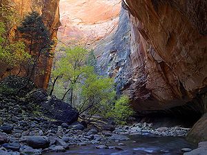
walls from 40 to 100 feet (10 to 30 m) apart, with pockets of forest on both sides. From Deep Creek to Big Springs is 2.7 miles (4 km). At Big Springs, the canyon narrows again, and the true Narrows begin. For most of the next 3.6 mile (6 km) stretch to the Mouth of the Narrows, the river runs wall to wall, with vertical sandstone cliffs on both sides. A mile (2 km) south of the Mouth of the Narrows is the Temple of Sinawava, where the river enters main Zion Canyon, a flat-floored, quarter to half-mile (400 to 800 m) wide canyon with sandstone mountains on each side, their summits 2400 feet (731.5 m) above. Eight miles (13 km) further south, where the canyon widens again, is the town of Springdale and the southern boundary of Zion National Park
Zion National Park
Zion National Park is located in the Southwestern United States, near Springdale, Utah. A prominent feature of the park is Zion Canyon, which is 15 miles long and up to half a mile deep, cut through the reddish and tan-colored Navajo Sandstone by the North Fork of the Virgin River...
.
Hiking The Narrows

The Narrows can be hiked either as a through-hike from Chamberlain Ranch to the Temple of Sinawava; or as an up-and-back hike from the Temple of Sinawava. The through-hike can be done in a day or as a two-day backpack trip. Chamberlain Ranch is accessed by the dirt North Fork Road east of the Park, and is situated in a rolling forest of aspen and scrub oak. No sign of the spectacular gorge ahead can be seen from the ranch. The hiker proceeds down the river and into an ever-deepening gorge, eventually getting to The Narrows and ending at the Temple of Sinawava. The hike is 16 miles (26 km) long and is very tiring because it is in the river itself. Permits are required before hiking the Narrows from the top and can be obtained at the Zion National Park Backcountry Desk.
The Narrows can also be explored from the bottom up, and the best places visited with less effort. The farther one goes upstream, the less crowded the canyon becomes.
Hiking in the river is strenuous. The water is often murky and the bottom of the river is covered with round, basalt rocks about the size of bowling balls. This makes foot protection and use of trekking poles or a walking stick essential. In the spring, The Narrows might be closed due to flooding while the snow melts off the upland areas to the north if the flow rate is higher than 120 cuft/s. During the summer, thunderstorms can cause The Narrows to flash flood
Flash flood
A flash flood is a rapid flooding of geomorphic low-lying areas—washes, rivers, dry lakes and basins. It may be caused by heavy rain associated with a storm, hurricane, or tropical storm or meltwater from ice or snow flowing over ice sheets or snowfields...
. Rain showers upriver can cause flash floods in the canyon without it raining over the canyon itself. Hikers should exercise caution when hiking The Narrows during rainy periods, as the winding canyon and sheer walls make approaching flash floods all the more sudden and difficult to evade.