
Test Way
Encyclopedia
The Test Way is a 49 miles (79 km) long-distance footpath
in England
from Walbury Hill
in West Berkshire
to Eling
in Hampshire
.
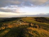
The northern end of the footpath
starts in the car park on Walbury Hill
. It passes through the towns of Romsey
and Totton and the villages of Linkenholt
, Ibthorpe
, Hurstbourne Tarrant
, St Mary Bourne
, Longparish
, Forton
, Wherwell
, Chilbolton
, Stockbridge
, Horsebridge
and Mottisfont
. The southern end of the footpath is at Eling Quay.
The trail also passes alongside Horsebridge railway station
. Much of the route between Kimbridge and Chilbolton follows the route of the former Andover and Redbridge Railway
.
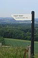
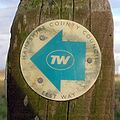
The entire route is waymarked
by metal and plastic disks found attached to wooden and metal posts, trees and street furniture
. There are several wooden 'finger' signs along the route that countdown the number of miles along the footpath
in both directions.
This route is shown as a series of green diamonds on Ordnance Survey 1:25,000 maps and as a series of red diamonds on Ordnance Survey 1:50,000 maps
Walbury Hill
is also the start of the Wayfarers Walk
.
:
Trail
A trail is a path with a rough beaten or dirt/stone surface used for travel. Trails may be for use only by walkers and in some places are the main access route to remote settlements...
in England
England
England is a country that is part of the United Kingdom. It shares land borders with Scotland to the north and Wales to the west; the Irish Sea is to the north west, the Celtic Sea to the south west, with the North Sea to the east and the English Channel to the south separating it from continental...
from Walbury Hill
Walbury Hill
Walbury Hill is the highest point in the traditional county of Berkshire in the UK at above sea level. It is also the highest point in the South East of England, West Berkshire being a constituent part of the South East of England...
in West Berkshire
West Berkshire
West Berkshire is a local government district in the ceremonial county of Berkshire, England, governed by a unitary authority . Its administrative capital is Newbury, located almost equidistantly between Bristol and London.-Geography:...
to Eling
Eling
Eling may refer to:*Eling, Berkshire*Totton and Eling, Hampshire*Eling Park, Chongqing...
in Hampshire
Hampshire
Hampshire is a county on the southern coast of England in the United Kingdom. The county town of Hampshire is Winchester, a historic cathedral city that was once the capital of England. Hampshire is notable for housing the original birthplaces of the Royal Navy, British Army, and Royal Air Force...
.
The northern end of the footpath
Trail
A trail is a path with a rough beaten or dirt/stone surface used for travel. Trails may be for use only by walkers and in some places are the main access route to remote settlements...
starts in the car park on Walbury Hill
Walbury Hill
Walbury Hill is the highest point in the traditional county of Berkshire in the UK at above sea level. It is also the highest point in the South East of England, West Berkshire being a constituent part of the South East of England...
. It passes through the towns of Romsey
Romsey
Romsey is a small market town in the county of Hampshire, England.It is 8 miles northwest of Southampton and 11 miles southwest of Winchester, neighbouring the village of North Baddesley...
and Totton and the villages of Linkenholt
Linkenholt
Linkenholt is a village near Andover in Hampshire, England with about 40 inhabitants. It was recorded in the Domesday Book of 1086 as Linchehou, when it was part of the land of the Abbey of St Peter of Gloucester....
, Ibthorpe
Ibthorpe
Ibthorpe is a village in Hampshire, England....
, Hurstbourne Tarrant
Hurstbourne Tarrant
Hurstbourne Tarrant is a village in Hampshire, England. It lies to the north of the county in the Test Valley.The Tarrant part of the name originates from 1226, when the village was given to the Cistercian Tarrant nunnery....
, St Mary Bourne
St Mary Bourne
St Mary Bourne is small village and civil parish in northwest Hampshire. It lies in the valley of the Bourne Rivulet, a tributary of the River Test 5 miles northeast of the town of Andover.-Governance:...
, Longparish
Longparish
Longparish is a small village in Hampshire, England. It lies on the western bank of the River Test.A Victorian monument, Dead Man's Plack, stands nearby.-External links:* * *...
, Forton
Forton, Hampshire
Forton is a village and civil parish in Hampshire, England. Its nearest town is Andover, which lies approximately 4 miles north-west. The village lies east to the River Test....
, Wherwell
Wherwell
Wherwell is a village on the River Test in Hampshire, England. The name may derive from its bubbling springs resulting in the Middle Ages place name “Hwerwyl” noted in AD 955, possibly meaning “kettle springs” or “cauldron springs.” Pronunciation of the name has ranged from “Hurrell” to “Wer-rel”...
, Chilbolton
Chilbolton
Chilbolton is a village and civil parish in Hampshire, England, near to Stockbridge. Its most notable feature is the Chilbolton Observatory situated on the disused RAF Chilbolton airfield...
, Stockbridge
Stockbridge, Hampshire
Stockbridge is a small town and civil parish in Hampshire, England. It has an acreage of and a population of little under 600 people according to the 2001 census in Hampshire, England. It lies on the River Test, in the Test Valley district and renowned for trout fishing. The A30 road goes through...
, Horsebridge
Horsebridge
Horsebridge is a small village in the civil parish of King's Somborne in the Test Valley district of Hampshire, England. Its nearest town is Stockbridge, which lies approximately 3.6 miles north-east from the village...
and Mottisfont
Mottisfont
Mottisfont is a village and civil parish in the Test Valley district of Hampshire, England, approximately 7km north west of Romsey. The village is best known as the location of Mottisfont Abbey...
. The southern end of the footpath is at Eling Quay.
The trail also passes alongside Horsebridge railway station
Horsebridge railway station
Horsebridge was a railway station on the closed Sprat and Winkle Line which served the Hampshire village of Houghton. It closed in 1964, a casualty of the closure programme proposed by the Beeching Axe which sounded the death knell for many rural railway stations.- Working years :The station,...
. Much of the route between Kimbridge and Chilbolton follows the route of the former Andover and Redbridge Railway
Sprat and Winkle Line
The Sprat and Winkle Line was the familiar name of a railway line which ran between Andover and Redbridge in Hampshire, UK. It was also known as the Andover to Redbridge Line....
.
The entire route is waymarked
Waymarking
Waymarking is an activity where people locate and log interesting locations around the world, usually with a GPS receiver and a digital camera. Waymarking differs from geocaching in that there is no physical container to locate at the given coordinates. Waymarking identifies points of interest for...
by metal and plastic disks found attached to wooden and metal posts, trees and street furniture
Street furniture
Street furniture is a collective term for objects and pieces of equipment installed on streets and roads for various purposes, including traffic barriers,...
. There are several wooden 'finger' signs along the route that countdown the number of miles along the footpath
Trail
A trail is a path with a rough beaten or dirt/stone surface used for travel. Trails may be for use only by walkers and in some places are the main access route to remote settlements...
in both directions.
This route is shown as a series of green diamonds on Ordnance Survey 1:25,000 maps and as a series of red diamonds on Ordnance Survey 1:50,000 maps
Walbury Hill
Walbury Hill
Walbury Hill is the highest point in the traditional county of Berkshire in the UK at above sea level. It is also the highest point in the South East of England, West Berkshire being a constituent part of the South East of England...
is also the start of the Wayfarers Walk
Wayfarers Walk
The Wayfarer's Walk is a long distance footpath in England from Walbury Hill, Berkshire to Emsworth, Hampshire.The footpath can be walked in either direction...
.
Places of interest
The following places of interest and hills can be found along the length of the Test Way, listed from Walbury HillWalbury Hill
Walbury Hill is the highest point in the traditional county of Berkshire in the UK at above sea level. It is also the highest point in the South East of England, West Berkshire being a constituent part of the South East of England...
:
- Combe GibbetCombe GibbetCombe Gibbet is a gibbet at the top of Gallows Down, near the village and just within the civil parish of Combe in Berkshire .-Location:...
- Ham Hill
- Hart Hill Down
- Wallop Hill Down
- Mottisfont AbbeyMottisfont AbbeyMottisfont Abbey is a historical abbey and country estate in England. Sheltered in the valley of the River Test, the property is now operated by the National Trust. About 200,000 people visit each year...
- Roke ManorRoke ManorRoke Manor is the name of the 17th century manor house approximately 2 km north-west of Romsey in Hampshire, England. The house and grounds are currently owned by Roke Manor Research Limited.- History :...
- Lower Test nature reserve
The route
These maps show the footpath in relation to nearby major roads. Maps are not on the same scale.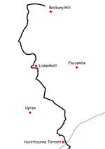 | 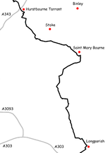 | 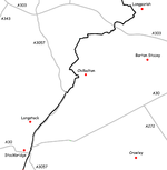 | 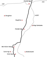 | 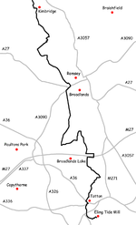 |
See also
- Long-distance footpaths in the UK
- North Wessex Downs Area of Outstanding Natural BeautyNorth Wessex Downs AONBThe North Wessex Downs Area of Outstanding Natural Beauty is located in the English counties of Berkshire, Hampshire, Oxfordshire and Wiltshire...