
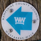
Wayfarers Walk
Encyclopedia
Trail
A trail is a path with a rough beaten or dirt/stone surface used for travel. Trails may be for use only by walkers and in some places are the main access route to remote settlements...
in England from Walbury Hill
Walbury Hill
Walbury Hill is the highest point in the traditional county of Berkshire in the UK at above sea level. It is also the highest point in the South East of England, West Berkshire being a constituent part of the South East of England...
, Berkshire
Berkshire
Berkshire is a historic county in the South of England. It is also often referred to as the Royal County of Berkshire because of the presence of the royal residence of Windsor Castle in the county; this usage, which dates to the 19th century at least, was recognised by the Queen in 1957, and...
to Emsworth
Emsworth
Emsworth is a large village the south coast of England, situated on the Hampshire side of the border between Hampshire and West Sussex. The village lies at the north end of an arm of Chichester Harbour, a large but shallow inlet of the English Channel....
, Hampshire
Hampshire
Hampshire is a county on the southern coast of England in the United Kingdom. The county town of Hampshire is Winchester, a historic cathedral city that was once the capital of England. Hampshire is notable for housing the original birthplaces of the Royal Navy, British Army, and Royal Air Force...
.
The footpath can be walked in either direction. The north-west end is at the car park on top of Walbury Hill, near to the landmark Combe Gibbet
Combe Gibbet
Combe Gibbet is a gibbet at the top of Gallows Down, near the village and just within the civil parish of Combe in Berkshire .-Location:...
, and the south-east end is Emsworth
Emsworth
Emsworth is a large village the south coast of England, situated on the Hampshire side of the border between Hampshire and West Sussex. The village lies at the north end of an arm of Chichester Harbour, a large but shallow inlet of the English Channel....
town square.
The footpath approximates an ancient route that might have been used by drovers
Droving
Droving is the practice of moving livestock over large distances by walking them "on the hoof".Droving stock to market, usually on foot and often with the aid of dogs, has a very long history in the old world...
taking cattle
Cattle
Cattle are the most common type of large domesticated ungulates. They are a prominent modern member of the subfamily Bovinae, are the most widespread species of the genus Bos, and are most commonly classified collectively as Bos primigenius...
for export. It passes through the towns of New Alresford
New Alresford
New Alresford or simply Alresford is a small town and civil parish in the City of Winchester district of Hampshire, England. It is situated some 12 km north-east of the city of Winchester and 20 km south-west of the town of Alton...
, Droxford
Droxford
Droxford is a village in Hampshire, England, lying in the Meon valley, and lies around 3¾ miles east of Bishop's Waltham within the new South Downs National Park. The A32 passes through the village between Gosport and Alton...
, Hambledon
Hambledon, Hampshire
Hambledon is a small village and civil parish in the county of Hampshire in England, situated about north of Portsmouth.Hambledon is best known as the 'Cradle of Cricket'. It is thought that Hambledon Club, one of the oldest cricket clubs known, was formed about 1750...
, Havant
Havant
Havant is a town in south east Hampshire on the South coast of England, between Portsmouth and Chichester. It gives its name to the borough comprising the town and the surrounding area. The town has rapidly grown since the end of the Second World War.It has good railway connections to London,...
and Emsworth
Emsworth
Emsworth is a large village the south coast of England, situated on the Hampshire side of the border between Hampshire and West Sussex. The village lies at the north end of an arm of Chichester Harbour, a large but shallow inlet of the English Channel....
and the villages of North Oakley
North Oakley
North Oakley is a hamlet in the civil parish of Hannington in the Basingstoke and Deane district of Hampshire, England. Its nearest town is Tadley, which lies approximately north-east from the village.-Governance:...
, Deane
Deane, Hampshire
Deane is a village and civil parish in the county of Hampshire, England. Its name appears in the name of the borough in which it is placed, Basingstoke and Deane.-Governance:...
, Dummer, Brown Candover
Brown Candover
Brown Candover is a village in Hampshire, England. The village belongs to the parish of the Candovers and its nearest town is New Alresford, 5 miles away from the village.-Governance:...
, Abbotstone
Abbotstone
Abbotstone is a hamlet in the United Kingdom in English county of Hampshire. It lies at an elevation of within the district of the City of Winchester, and the closest town is New Alresford. It is now in the parish of Itchen Stoke, but was formerly its own parish. Abbotstone lies along the...
, Cheriton
Cheriton, Hampshire
Cheriton Is a small village and civil parish located near the city of Winchester, in Hampshire, England. The settlement is perhaps most famous for being the location of the Battle of Cheriton in the English Civil War. Cheriton is also the Source of the River Itchen.Facilities and ServicesCheriton...
, Hinton Ampner
Hinton Ampner
Hinton Ampner House is a stately home with gardens within the parish of Hinton Ampner, near Alresford, Hampshire, England.The house and garden are owned by the National Trust and are open to the public....
, Kilmeston
Kilmeston
Kilmeston is a small village and civil parish in the City of Winchester district of Hampshire, England....
, Soberton
Soberton
Soberton is a village in the Meon Valley, Hampshire, England and is bordered by villages such as Newtown and Droxford. It is listed in the Domesday Book under its original name, 'Sudbertone'/'Sudbertune', and comes under Winchester City Council....
, and Denmead
Denmead
Denmead is a village in Hampshire, England. It is part of the City of Winchester district. As of 2005, it had a population of 6,457 and an electorate of 4,987....
.
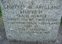
By the path is a memorial to the first flight of Geoffrey de Havilland
Geoffrey de Havilland
Captain Sir Geoffrey de Havilland, OM, CBE, AFC, RDI, FRAeS, was a British aviation pioneer and aircraft engineer...
. The footpath also passes close to Watership Down, Hampshire
Watership Down, Hampshire
Watership Down is a hill, or down, at Ecchinswell in the civil parish of Ecchinswell, Sydmonton and Bishops Green in the English county of Hampshire. It rises fairly steeply on its northern flank , but to the south the slope is much gentler . .The Down is best known as the setting for Richard...
.
The footpath is waymarked
Waymarking
Waymarking is an activity where people locate and log interesting locations around the world, usually with a GPS receiver and a digital camera. Waymarking differs from geocaching in that there is no physical container to locate at the given coordinates. Waymarking identifies points of interest for...
by metal and plastic disks found attached to wooden and metal posts, trees and street furniture. It has also spawned several circular routes that use sections of the main footpath. These are also waymarked.
This route is shown as a series of green diamonds on Ordnance Survey 1:25,000 maps and as a series of red diamonds on Ordnance Survey 1:50,000 maps.
Walbury Hill is also the start of the Test Way
Test Way
The Test Way is a long-distance footpath in England from Walbury Hill in West Berkshire to Eling in Hampshire.The northern end of the footpath starts in the car park on Walbury Hill...
.
Places of interest
The following places of interest, hillfort sites and hills can be found along the length of the Walk (listed from southeast to northwest):- Fort Purbrook
- The source of the River ItchenRiver Itchen, HampshireThe River Itchen is a river in Hampshire, England. It flows from mid-Hampshire to join with Southampton Water below the Itchen Bridge in the city of Southampton. The river has a total length of , and is noted as one of England's - if not one of the World's - premier chalk streams for fly fishing,...
- Tidley Hill
- Watership DownWatership DownWatership Down is a classic heroic fantasy novel, written by English author Richard Adams, about a small group of rabbits. Although the animals in the story live in their natural environment, they are anthropomorphised, possessing their own culture, language , proverbs, poetry, and mythology...
- Ladle HillLadle HillLadle Hill lies on Great Litchfield Down, near the village of Burghclere and Watership Down, in north Hampshire. It is immediately to the East of Beacon Hill. Part of the hill is a biological SSSI, number 1000642, first notified in 1978. It is 232 metres high and has a hill forts and Tumulus...
and iron age hillfort and SSSI - Pilot Hill and Dean Hill
- Walbury HillWalbury HillWalbury Hill is the highest point in the traditional county of Berkshire in the UK at above sea level. It is also the highest point in the South East of England, West Berkshire being a constituent part of the South East of England...
and the iron age hillfort of Walbury Camp - The start of the Test WayTest WayThe Test Way is a long-distance footpath in England from Walbury Hill in West Berkshire to Eling in Hampshire.The northern end of the footpath starts in the car park on Walbury Hill...
Map
These maps show the footpath in relation to nearby major roads. Maps are not on the same scale.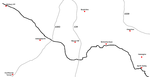 | 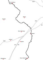 | 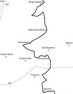 | 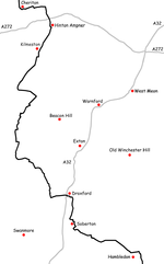 | 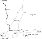 |
See also
- Long-distance footpaths in the UK
- North Wessex Downs Area of Outstanding Natural BeautyNorth Wessex Downs AONBThe North Wessex Downs Area of Outstanding Natural Beauty is located in the English counties of Berkshire, Hampshire, Oxfordshire and Wiltshire...
External links
- Hampshire County Council information on the Wayfarer's Walk
- Wayfarer's Walk (Walking on the Web)
- Wayfarer's Walk (Long Distance Walkers’ Association)