
Södertörn
Encyclopedia
Peninsula
A peninsula is a piece of land that is bordered by water on three sides but connected to mainland. In many Germanic and Celtic languages and also in Baltic, Slavic and Hungarian, peninsulas are called "half-islands"....
in eastern Södermanland
Södermanland
', sometimes referred to under its Latin form Sudermannia or Sudermania, is a historical province or landskap on the south eastern coast of Sweden. It borders Östergötland, Närke, Västmanland and Uppland. It is also bounded by lake Mälaren and the Baltic sea.In Swedish, the province name is...
, Sweden
Sweden
Sweden , officially the Kingdom of Sweden , is a Nordic country on the Scandinavian Peninsula in Northern Europe. Sweden borders with Norway and Finland and is connected to Denmark by a bridge-tunnel across the Öresund....
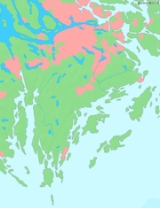
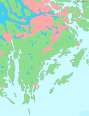
, which is bordered by:
- Lake MälarenMälarenLake Mälaren is the third-largest lake in Sweden, after Lakes Vänern and Vättern. Its area is 1,140 km² and its greatest depth is 64 m. Mälaren spans 120 kilometers from east to west...
and the inlet of SaltsjönSaltsjönSaltsjön is a bay of the Baltic Sea that extends from Stockholm archipelago to the inner city of Stockholm. Its innermost part reaches the eastern shore of Gamla stan at Skeppsbrokajen. It is navigable for large craft and the major ferry lines to and from Stockholm pass through it...
(a part of Baltic SeaBaltic SeaThe Baltic Sea is a brackish mediterranean sea located in Northern Europe, from 53°N to 66°N latitude and from 20°E to 26°E longitude. It is bounded by the Scandinavian Peninsula, the mainland of Europe, and the Danish islands. It drains into the Kattegat by way of the Øresund, the Great Belt and...
) to the north, - Himmerfjärden and Hallsfjärden (parts of Baltic Sea) to the west and
- The Baltic SeaBaltic SeaThe Baltic Sea is a brackish mediterranean sea located in Northern Europe, from 53°N to 66°N latitude and from 20°E to 26°E longitude. It is bounded by the Scandinavian Peninsula, the mainland of Europe, and the Danish islands. It drains into the Kattegat by way of the Øresund, the Great Belt and...
(Stockholm ArchipelagoStockholm archipelagoThe Stockholm archipelago is the largest archipelago of Sweden, and one of the largest archipelagos of the Baltic Sea.-Geography:The archipelago extends from Stockholm roughly 60 kilometers to the east...
) to the east and the south.
However, even though the peninsula is typically thought of as part of the Swedish mainland, its connection to the mainland is broken by the Södertälje Canal
Södertälje Canal
The Södertälje Canal is a canal connecting the lake Mälaren with the Baltic Sea, at the city of Södertälje. It is 5,2 km long, and it has one lock. The size of this lock is the largest in Scandinavia by allowed ship size. The lock is 135 m long and 17 m wide. The water level difference between...
, and it can actually be called an island.
Since 2005, the whole of Södertörn has been included in Greater Stockholm. Before that, the southern parts of the peninsula, which lie within Nynäshamn
Nynäshamn Municipality
Nynäshamn Municipality is a municipality in Stockholm County in east central Sweden. Its seat is located in the city of Nynäshamn....
municipality, and the western parts, which are in Södertälje
Södertälje Municipality
Södertälje Municipality is a municipality in Stockholm County in east central Sweden. Its seat is located in the city of Södertälje....
were not part of Greater Stockholm.
The northern areas of Södertörn are to a large extent made up of rift-valley
Rift valley
A rift valley is a linear-shaped lowland between highlands or mountain ranges created by the action of a geologic rift or fault. This action is manifest as crustal extension, a spreading apart of the surface which is subsequently further deepened by the forces of erosion...
countryside (and urban areas) with high ground which is either pine forest or bare. The long valleys of the south become level ground, while those in the north contain salt water. The bedrock is almost entirely gneiss
Gneiss
Gneiss is a common and widely distributed type of rock formed by high-grade regional metamorphic processes from pre-existing formations that were originally either igneous or sedimentary rocks.-Etymology:...
.
The peninsula’s name (á [...] Taurinum in 1225, Tør in 1283, a Tørinne in 1383 and eventually ‘‘Södertörn’’ since 1645) derives from the Old Norse
Old Norse
Old Norse is a North Germanic language that was spoken by inhabitants of Scandinavia and inhabitants of their overseas settlements during the Viking Age, until about 1300....
dialect word tor, meaning "broken rocky beaches", which cut deep into the coast of Södertörn.
The highest point on Södertörn is Tornberget (in Haninge
Haninge Municipality
Haninge Municipality is a municipality in Stockholm County in east central Sweden. Its seat is located in Handen.Haninge Municipality was formed in 1971 when Västerhaninge and Österhaninge were united....
municipality) at 110.9 metres above sea level. It is located in Hanveden, a large area of forest south of Stockholm
Stockholm
Stockholm is the capital and the largest city of Sweden and constitutes the most populated urban area in Scandinavia. Stockholm is the most populous city in Sweden, with a population of 851,155 in the municipality , 1.37 million in the urban area , and around 2.1 million in the metropolitan area...
, which eastern areas partially form the Tyresta National Park
Tyresta National Park
Tyresta National Park is a national park with a surrounding nature reserve in Sweden, located in Haninge and Tyresö municipalities in Stockholm County....
.
The southernmost parts of Södertörn were connected to Stockholm in 1901, when the Nynäs railway line was opened. The railway runs between Nynäshamn
Nynäshamn Municipality
Nynäshamn Municipality is a municipality in Stockholm County in east central Sweden. Its seat is located in the city of Nynäshamn....
in the south and Älvsjö
Älvsjö
Älvsjö is a district of the city of Stockholm Municipality in Sweden. Located in Söderort and a district in the borough Älvsjö. It has the biggest rentable facility in northern Europe called Stockholm International Fairs. In 2008, total population was 956 inhabitants....
in the north, where it joins to the main southern railway.
Municipalities of Södertörn
- BotkyrkaBotkyrka MunicipalityBotkyrka Municipality is a municipality in Stockholm County in east central Sweden, not far from the capital Stockholm. Its seat is located in the town of Tumba....
- HaningeHaninge MunicipalityHaninge Municipality is a municipality in Stockholm County in east central Sweden. Its seat is located in Handen.Haninge Municipality was formed in 1971 when Västerhaninge and Österhaninge were united....
- HuddingeHuddinge MunicipalityHuddinge Municipality is a municipality in Stockholm County in east central Sweden. Its seat is located in Huddinge, which is a part of Stockholm urban area.The municipality is the second most populated in Stockholm County....
- NackaNacka MunicipalityNacka Municipality is a municipality in Stockholm County in east central Sweden. Its seat is located at Nacka. The municipality is situated just east of the capital Stockholm and the western parts are considered a suburban part of the Stockholm urban area.The present municipality was created in...
(east of Skurusundet) - NynäshamnNynäshamn MunicipalityNynäshamn Municipality is a municipality in Stockholm County in east central Sweden. Its seat is located in the city of Nynäshamn....
- SalemSalem MunicipalitySalem Municipality is a municipality in Stockholm County in east central Sweden. The name traces its origins from Slaem in the 16th century, but was later changed to Salem, the Biblical name of Jerusalem...
- Söderort, the southern part of Stockholm MunicipalityStockholm MunicipalityStockholm Municipality or the City of Stockholm is a municipality in Stockholm County in east central Sweden. It is the largest of the 290 municipalities of the country in terms of population, but one of the smaller in terms of area, making it the most densely populated...
- SödertäljeSödertälje MunicipalitySödertälje Municipality is a municipality in Stockholm County in east central Sweden. Its seat is located in the city of Södertälje....
(east of the Södertälje Canal) - TyresöTyresö MunicipalityTyresö Municipality is a municipality in Stockholm County in east central Sweden on the coast of the Baltic Sea. Its seat is located in Bollmora.Most of Tyresö Municipality lies within the Stockholm urban area.-History:...
All these municipalities are located both in Stockholm County
Stockholm County
Stockholm County is a county or län on the Baltic sea coast of Sweden. It borders Uppsala County and Södermanland County. It also borders Mälaren and the Baltic Sea. The city of Stockholm is the capital of Sweden. Stockholm County is divided by the historic provinces of Uppland and Södermanland...
and the province
Provinces of Sweden
The provinces of Sweden, landskap, are historical, geographical and cultural regions. Sweden has 25 provinces and they have no administrative function, but remain historical legacies and the means of cultural identification....
Södermanland
Södermanland
', sometimes referred to under its Latin form Sudermannia or Sudermania, is a historical province or landskap on the south eastern coast of Sweden. It borders Östergötland, Närke, Västmanland and Uppland. It is also bounded by lake Mälaren and the Baltic sea.In Swedish, the province name is...
. Though incorrect, the two remaining municipalities to fulfil these criteria — Södertälje
Södertälje Municipality
Södertälje Municipality is a municipality in Stockholm County in east central Sweden. Its seat is located in the city of Södertälje....
and Nykvarn
Nykvarn Municipality
Nykvarn Municipality is a municipality in Stockholm County in east central Sweden. Its seat is located in the town of Nykvarn.Nykvarn is a young municipality, and is the result of the splitting of Södertälje Municipality in 1999...
— both located west of Södertälje Canal, are sometimes also thought of as part of Södertörn.