
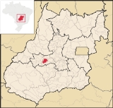
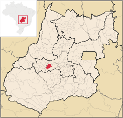
São Luís de Montes Belos
Encyclopedia
| São Luís de Montes Belo | |
|---|---|
| State | Goiás Goiás Goiás is a state of Brazil, located in the central part of the country. The name Goiás comes from the name of an indigenous community... |
| Area: | 826.2 km² |
| Population: | 26,784 (IBGE 2007) |
| Elevation: | 579 m (1,900 ft) above sea level |
| Postcode (CEP): | 76100-000 |
| IBGE statistical microregion: | Anicuns Microregion Anicuns Microregion The Anicuns Microregion is a geographical division in the state of Goiás, Brazil. It is made up of 13 municipalities located near Anicuns, a small city and municipality west of Goiânia... |
| Became a city: | 1953 |
| Mayor: | Marisa Assis de Oliveira Guimarães |
| Distance to Goiânia Goiânia -Climate:The city has a tropical wet and dry climate with an average temperature of . There's a wet season, from October to April, and a dry one, from May to September. Annual rainfall is around 1,520 mm.... : |
122 km |
| Website: | none |
| Geographical coordinates: | 16°31′20"S 50°22′44"W |
City
A city is a relatively large and permanent settlement. Although there is no agreement on how a city is distinguished from a town within general English language meanings, many cities have a particular administrative, legal, or historical status based on local law.For example, in the U.S...
and municipality
Municipality
A municipality is essentially an urban administrative division having corporate status and usually powers of self-government. It can also be used to mean the governing body of a municipality. A municipality is a general-purpose administrative subdivision, as opposed to a special-purpose district...
in the State of Goiás
Goiás
Goiás is a state of Brazil, located in the central part of the country. The name Goiás comes from the name of an indigenous community...
, Brazil
Brazil
Brazil , officially the Federative Republic of Brazil , is the largest country in South America. It is the world's fifth largest country, both by geographical area and by population with over 192 million people...
.
Location
It is located in the Anicuns MicroregionAnicuns Microregion
The Anicuns Microregion is a geographical division in the state of Goiás, Brazil. It is made up of 13 municipalities located near Anicuns, a small city and municipality west of Goiânia...
, 123 kilometers from the state capital, Goiânia
Goiânia
-Climate:The city has a tropical wet and dry climate with an average temperature of . There's a wet season, from October to April, and a dry one, from May to September. Annual rainfall is around 1,520 mm....
, to which it is connected by highway GO-060. It is bounded by the following municipalities: Sanclerlândia
Sanclerlândia
Sanclerlândia is a small town and municipality in western Goiás state, Brazil. The population was 7,641 in 2005 and the total area of the municipality was 496.8 km².-Location:...
, Adelândia
Adelândia
Adelândia is a small town and municipality in eastern Goiás state, Brazil.-Location:The distance to the state capital Goiânia is 129 km. while the distance to the regional center São Luís de Montes Belos is 6 km....
, Turvânia
Turvânia
Turvânia is a small town and municipality in eastern Goiás state, Brazil.-Location:Turvânia is located west of Goiânia, east of São Luís de Montes Belos....
, Firminópolis
Firminópolis
Firminópolis is a small town and municipality in eastern Goiás state, Brazil.-Location and connections:*Distance to São Luís de Montes Belos: 9 km....
, Aurilândia
Aurilândia
Aurilândia is a small town and municipality in eastern Goiás state, Brazil.-Location:The distance to the state capital is 146 km. while the distance to the main regional center São Luís de Montes Belos is 23 km....
, Sanclerlândia
Sanclerlândia
Sanclerlândia is a small town and municipality in western Goiás state, Brazil. The population was 7,641 in 2005 and the total area of the municipality was 496.8 km².-Location:...
and Córrego do Ouro
Córrego do Ouro
Córrego do Ouro is a small town and municipality in eastern Goiás state, Brazil.-Location and Highway Connections:Córrego do Ouro is located in the Iporá Microregion west of the state capital, Goiânia. It is 45 km. northwest of São Luís de Montes Belos, the largest town in the region. ...
. The distance to Goiânia
Goiânia
-Climate:The city has a tropical wet and dry climate with an average temperature of . There's a wet season, from October to April, and a dry one, from May to September. Annual rainfall is around 1,520 mm....
is 129 km. Highway communications are made by GO-060 / Trindade
Trindade, Goiás
Trindade is a city and municipality in Goiás state, Brazil. It is famous for the religious celebrations held there in July and is now the third most important pilgrimage site in Brazil....
/ Nazário
Nazário
Nazário is a small town and municipality in eastern Goiás state, Brazil.-Location:Nazário is located 74 km. west of the state capital, Goiânia a few kilometers west of the Rio dos Bois, a major tributary of the Paranaíba River. The regional center, Anicuns, is 21 km to the northwest...
/ Turvânia
Turvânia
Turvânia is a small town and municipality in eastern Goiás state, Brazil.-Location:Turvânia is located west of Goiânia, east of São Luís de Montes Belos....
/ Firminópolis
Firminópolis
Firminópolis is a small town and municipality in eastern Goiás state, Brazil.-Location and connections:*Distance to São Luís de Montes Belos: 9 km....
.
Demographics
The population density was 32.42 inhab/km² (2007). The urban population was 23,439 and the rural population was 3,345 (2007).
Geography
The average elevation is 630 meters above sea level and most of the land is flat or hilly. There are many rivers, the most important being the Fartura, Cerrado, and São Domingos. The main streams are the Santana, Santa Rosa, São Manoel and Diamantina. The climate of the region is hot and semi-humid, with an average temperature ranging from 27°C fto 28°C. According to the weather station in São Luís, the minimum temperature is 19°C and the maximum, 35°C.The economy
Cattle raising is the most important economic activity in São Luís. The pasture land is extensive and the main breeds raised are GirGir cattle
The Gir or Gyr is one of the principal Zebu breeds originating in India. It has been used locally in the improvement of other breeds including the Red Sindhi and the Sahiwal. It was also one of the breeds used in the development of the Brahman breed in North America...
and Nelore
Rei Ayanami
is a fictional character from the Neon Genesis Evangelion franchise, a Japanese anime from Gainax. She is the First Child and pilot of the Evangelion Unit 00....
. Most cattle are shipped out to be slaughtered in larger urban centers. Swine, poultry, and horse raising are also important activities, as well as traditional agriculture. The size of the cattle herd was 120,000 in 2006. IBGE
Milk production is important in the region and there are two dairies. The town has been chosen to implement a Technological Milk Center (Centro Tecnológico do Leite (CTL), which will be a training site for the technicians who assist the cattle farmers.
The main natural resource is wood, which is used in construction and in the furniture industry. This small furniture industry has given the town the rather exaggerated nickname, ""Capital Industrial do Oeste Goiano"". The main agricultural products are bananas 425 hectares, hearts of palm, rice, and corn.
Education and Health
There was a campus of the UEG - Faculdade de Educação, Ciências e Letras de São Luiz de Montes Belos (763 students in 2004)The adult literacy rate was 87.9% (2000) (the national average was 86.4%). In the health sector there were 2 hospitals with 72 beds (2006). The infant mortality rate was 26.08 (2000) (national average was 33.0). On the Municipal Human Development Index
Human Development Index
The Human Development Index is a composite statistic used to rank countries by level of "human development" and separate "very high human development", "high human development", "medium human development", and "low human development" countries...
São Luís had a classification of 0.752. This ranked it 71 out of 242 municipalities in the state and 1,812 out of 5,507 municipalities in the country (2000).
For the complete list see frigoletto.com.br
History
The settlement of São Luís began in 1857 with a ranch belonging to the Neto family. This was near a stream flowing near the São Luíz hills, where there were fertile lands that lent themselves to the cultivation of sugar cane and the raising of cattle. The founder, José Neto Cerqueira Leão Sobrinho gave the name of São Luíz de Montes Belos in honor of Saint Louis and the beautiful hills nearby. In 1948 it was raised to the category of district belonging to GoiásGoiás, Goiás
Goiás is a small city and municipality in the state of Goiás in Brazil. The population was 24,072 in a total area of 3,108 km² . It is the former capital of the state and preserves much of its colonial heritage...
. In 1953 it became a municipality. The spelling of the name "Luís" is sometimes with "z" instead of "s" and is often without the accent on the letter "i". Official spelling used by Seplan is São Luis de Montes Belos. The first mayor was "Nenen de Brito", Deusdedit de Brito, his birth certificate name; respectful man who continually served the people of São Luis de Montes Belos as a representative for 28 years.
See also
- List of municipalities in Goiás
- Microregions of Goiás
The first Mayor was "Nenen de Brito", Deusdedit Brito.