
Nazário
Encyclopedia
| Nazário | |
|---|---|
| State | Goiás Goiás Goiás is a state of Brazil, located in the central part of the country. The name Goiás comes from the name of an indigenous community... |
| Area: | 300.1 km² |
| Population: | 4,954 (IBGE 2007) |
| Population Density; | 24,07 hab/km² (2007) |
| Elevation: | 615m above sea level |
| Postcode (CEP): | 76180-000 |
| IBGE statistical microregion: | Anicuns Microregion Anicuns Microregion The Anicuns Microregion is a geographical division in the state of Goiás, Brazil. It is made up of 13 municipalities located near Anicuns, a small city and municipality west of Goiânia... |
| Became a city: | 1958 |
| Distance to Goiânia Goiânia -Climate:The city has a tropical wet and dry climate with an average temperature of . There's a wet season, from October to April, and a dry one, from May to September. Annual rainfall is around 1,520 mm.... : |
142 km. |
| Mayor: | João Augusto Machado |
| Website: | none |
| Geographical Coordinates: | 16°35′05"S 49°52′55"W |
Town
A town is a human settlement larger than a village but smaller than a city. The size a settlement must be in order to be called a "town" varies considerably in different parts of the world, so that, for example, many American "small towns" seem to British people to be no more than villages, while...
and municipality
Municipality
A municipality is essentially an urban administrative division having corporate status and usually powers of self-government. It can also be used to mean the governing body of a municipality. A municipality is a general-purpose administrative subdivision, as opposed to a special-purpose district...
in eastern Goiás
Goiás
Goiás is a state of Brazil, located in the central part of the country. The name Goiás comes from the name of an indigenous community...
state, Brazil
Brazil
Brazil , officially the Federative Republic of Brazil , is the largest country in South America. It is the world's fifth largest country, both by geographical area and by population with over 192 million people...
.
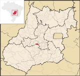
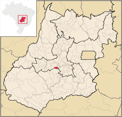
Location
Nazário is located 74 km. west of the state capital, GoiâniaGoiânia
-Climate:The city has a tropical wet and dry climate with an average temperature of . There's a wet season, from October to April, and a dry one, from May to September. Annual rainfall is around 1,520 mm....
a few kilometers west of the Rio dos Bois, a major tributary of the Paranaíba River
Paranaíba River
The Paranaíba River is a Brazilian river whose source lies in the state of Minas Gerais in the Mata da Corda mountains, municipality of Rio Paranaíba, at an altitude of 1,148 meters; on the other face of this mountain chain are the sources of the Abaeté river, tributary of the São Francisco River...
. The regional center, Anicuns
Anicuns
Anicuns is a small city and municipality in central Goiás state, Brazil.-Geographical Facts:Anicuns is located in the Anicuns Microregion, which includes 13 cities with a population of 103276 inhabitants in a total area of 5483.10 km²....
, is 21 km to the northwest. Highway connections from Goiânia
Goiânia
-Climate:The city has a tropical wet and dry climate with an average temperature of . There's a wet season, from October to April, and a dry one, from May to September. Annual rainfall is around 1,520 mm....
are made by state highway BR-069 west from Goiânia
Goiânia
-Climate:The city has a tropical wet and dry climate with an average temperature of . There's a wet season, from October to April, and a dry one, from May to September. Annual rainfall is around 1,520 mm....
, through Trindade
Trindade
-Transportation:Trindade are linked with São Tomé and Príncipe's only highways linking to the capital city of São Tomé, another linking Neves and Santana and another linking to Guadalupe as well....
, Santa Bárbara de Goiás
Santa Bárbara de Goiás
Santa Bárbara de Goiás is a small town and municipality in eastern Goiás state, Brazil.-Location:Santa Bárbara is located due west of Goiânia. Nearby towns are Trindade , and Nazário is 25 km...
, and then 12 kilometers west to Nazário. Neighboring municipalities are Turvânia
Turvânia
Turvânia is a small town and municipality in eastern Goiás state, Brazil.-Location:Turvânia is located west of Goiânia, east of São Luís de Montes Belos....
, Anicuns
Anicuns
Anicuns is a small city and municipality in central Goiás state, Brazil.-Geographical Facts:Anicuns is located in the Anicuns Microregion, which includes 13 cities with a population of 103276 inhabitants in a total area of 5483.10 km²....
, Avelinópolis
Avelinópolis
Avelinópolis is a small town and municipality in eastern Goiás state, Brazil.-Communications and Location:The distance to the regional center of is 26 km. Highway connections from the state capital are made by state highway BR-069 west from Goiânia, through Trindade, Santa Bárbara de Goiás,...
, and Santa Bárbara de Goiás
Santa Bárbara de Goiás
Santa Bárbara de Goiás is a small town and municipality in eastern Goiás state, Brazil.-Location:Santa Bárbara is located due west of Goiânia. Nearby towns are Trindade , and Nazário is 25 km...
Demographics
In 2007 there were 6,702 people living in the urban area and 521 living in the rural area. The population has increased by about 1,000 people since 1980. Between 2000 and 2007 the geometric population growth rate was 1.23.%.The economy
The economy was based on agriculture, cattle raising, services, and a small number of modest transformation industries. There was 1 meat-packing plant—Gelnex Indústria e Comércio Ltda—and 1 banking institution—Banco Itaú S.A.In 2007 there were 39,600 head of cattle. The main agricultural products were rice, bananas, coffee, sugarcane, beans, oranges, manioc, and corn. Corn was the only crop with more than 1,000 planted hectares.
Health and education
The health sector was modest with 1 hospital (18 beds). The infant mortality rate was 16.30, well below the national rate of 35.0 in 2000. the educational sector was composed ofThe school system had 6 schools and 2,236 students (2006). There were no institutions of higher learning. The adult literacy rate was 87.0%, higher than the national average of 86.4% in 2000.
History
The name of the town comes from the first name of its founder, Nazário de Pereira Oliveira, who first settled in the region in the nineteenth century.He built the first house at the meeting of the waterways Córrego dos Buriti and Rio dos Bois. Later a chapel was erected in honor of Our Lady of the Conception. Moved by religious faith several families arrived and by 1930 the settlement took on the name of Nazário. At first it was a district of the now extinct municipality of Novo Horizonte, which later, in 1938 became Anicuns
Anicuns
Anicuns is a small city and municipality in central Goiás state, Brazil.-Geographical Facts:Anicuns is located in the Anicuns Microregion, which includes 13 cities with a population of 103276 inhabitants in a total area of 5483.10 km²....
. In 1948 Nazário got its emancipation and became an independent municipalitiy. Source: Sepin
Ranking on the Municipal Human Development Index
Human Development Index
The Human Development Index is a composite statistic used to rank countries by level of "human development" and separate "very high human development", "high human development", "medium human development", and "low human development" countries...
- MHDI: 0.765
- State ranking: 47 (out of 242 municipalities)
- National ranking: 1,459 (out of 5,507 municipalities)
For the complete list see frigoletto.com.br
See also
- List of municipalities in Goiás
- Microregions of Goiás