
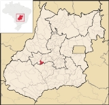
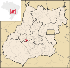
Aurilândia
Encyclopedia
| Aurilândia | |
|---|---|
| State | Goiás Goiás Goiás is a state of Brazil, located in the central part of the country. The name Goiás comes from the name of an indigenous community... |
| Area: | 567.0 km² |
| Population: | 3,719 (IBGE 2007 estimate) |
| Elevation: | 520 m above sea level |
| Postcode (CEP): | 76120-000 |
| IBGE statistical microregion: | Anicuns Microregion Anicuns Microregion The Anicuns Microregion is a geographical division in the state of Goiás, Brazil. It is made up of 13 municipalities located near Anicuns, a small city and municipality west of Goiânia... |
| Became a city: | 1948 |
| Distance to Goiânia Goiânia -Climate:The city has a tropical wet and dry climate with an average temperature of . There's a wet season, from October to April, and a dry one, from May to September. Annual rainfall is around 1,520 mm.... : |
146 km |
| Website: | none (March 2008) |
| Coordinates | 15°41′06"S 50°28′54"W |
Town
A town is a human settlement larger than a village but smaller than a city. The size a settlement must be in order to be called a "town" varies considerably in different parts of the world, so that, for example, many American "small towns" seem to British people to be no more than villages, while...
and municipality
Municipality
A municipality is essentially an urban administrative division having corporate status and usually powers of self-government. It can also be used to mean the governing body of a municipality. A municipality is a general-purpose administrative subdivision, as opposed to a special-purpose district...
in eastern Goiás
Goiás
Goiás is a state of Brazil, located in the central part of the country. The name Goiás comes from the name of an indigenous community...
state, Brazil
Brazil
Brazil , officially the Federative Republic of Brazil , is the largest country in South America. It is the world's fifth largest country, both by geographical area and by population with over 192 million people...
.
Location
The distance to the state capital is 146 km. while the distance to the main regional center São Luís de Montes BelosSão Luís de Montes Belos
São Luís de Montes Belos is a small city and municipality in the State of Goiás, Brazil.-Location:It is located in the Anicuns Microregion, 123 kilometers from the state capital, Goiânia, to which it is connected by highway GO-060...
is 23 km.
Highway connections from Goiânia are made by state highway BR-069 west from Goiânia
Goiânia
-Climate:The city has a tropical wet and dry climate with an average temperature of . There's a wet season, from October to April, and a dry one, from May to September. Annual rainfall is around 1,520 mm....
, through Trindade
Trindade
-Transportation:Trindade are linked with São Tomé and Príncipe's only highways linking to the capital city of São Tomé, another linking Neves and Santana and another linking to Guadalupe as well....
, São Luís de Montes Belos
São Luís de Montes Belos
São Luís de Montes Belos is a small city and municipality in the State of Goiás, Brazil.-Location:It is located in the Anicuns Microregion, 123 kilometers from the state capital, Goiânia, to which it is connected by highway GO-060...
, and then 23 kilometers south to Aurilândia.
Neighboring municipalities are São Luís de Montes Belos
São Luís de Montes Belos
São Luís de Montes Belos is a small city and municipality in the State of Goiás, Brazil.-Location:It is located in the Anicuns Microregion, 123 kilometers from the state capital, Goiânia, to which it is connected by highway GO-060...
, Firminópolis
Firminópolis
Firminópolis is a small town and municipality in eastern Goiás state, Brazil.-Location and connections:*Distance to São Luís de Montes Belos: 9 km....
, São João da Paraúna
São João da Paraúna
São João da Paraúna is a small town and municipality in western Goiás state, Brazil.-Location:São João is located west of Goiânia, 36 km...
, and Paraúna
Paraúna
Paraúna is a small town and municipality in southwestern Goiás state, Brazil. It has strange rock formations and is a large producer of cotton and soybeans.-Location:...
.
Demographics
- Population density: 6,58 inhab/km² (2007)
- Population growth rate: -1.93% 1996/2007
- Population in 1980: 4,953
- Population in 2007: 3,719
- Urban population: 2,762
Economy
The main economic activities are cattle raising, agriculture, commerce, and small transformation industries. Public administration is the largest employer. There is a large informal economy. There were 61,200 head of cattle (6,000 milking cows) in 2006. The main agricultural products were bananas, hearts of palm, rice, manioc, and corn. There were 400 automobiles and pickup trucks in 2007, giving a ratio of 9 inhabitants for each motor vehicle.- Number of farms: 341
- Total agricultural area: 50,397 ha.
- Planted area: 610 ha.
- Area of natural pasture: 39,767e
- Persons employed in agriculture: 986 (IBGE 2006)
Health and education
The infant mortality rate in 2000 was 24.88. There was 1 small hospital (2007) with 19 beds. The literacy rate in 2000 was 84.3%. There were 3 schools with 826 students in 2006.The score on the Municipal Human Development Index
Human Development Index
The Human Development Index is a composite statistic used to rank countries by level of "human development" and separate "very high human development", "high human development", "medium human development", and "low human development" countries...
was 0.732, giving it a state ranking of 140 (out of 242 municipalities) and a national ranking of 2,390 (out of 5,507 municipalities). For the complete list see frigoletto.com.br