
Conowingo Dam
Overview
Dam
A dam is a barrier that impounds water or underground streams. Dams generally serve the primary purpose of retaining water, while other structures such as floodgates or levees are used to manage or prevent water flow into specific land regions. Hydropower and pumped-storage hydroelectricity are...
in the Lower Susquehanna River
Susquehanna River
The Susquehanna River is a river located in the northeastern United States. At long, it is the longest river on the American east coast that drains into the Atlantic Ocean, and with its watershed it is the 16th largest river in the United States, and the longest river in the continental United...
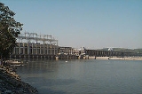
. The dam, one of the largest non-federal hydroelectric dams in the US, is classified as a medium height, masonry gravity type dam. The dam is located in Maryland
Maryland
Maryland is a U.S. state located in the Mid Atlantic region of the United States, bordering Virginia, West Virginia, and the District of Columbia to its south and west; Pennsylvania to its north; and Delaware to its east...
, spanning the Cecil
Cecil County, Maryland
Cecil County is a county located in the U.S. state of Maryland. It is part of the Delaware Valley. It was named for Cæcilius Calvert, 2nd Baron Baltimore , who was the first Proprietary Governor of the colony of Maryland from 1632 until his death in 1675. The county seat is Elkton. The newspaper...
and Harford
Harford County, Maryland
Harford County is a county in the U.S. state of Maryland. In 2010, its population was 244,826. Its county seat is Bel Air. Harford County forms part of the Baltimore-Washington Metropolitan Area.-History:...
county border — 9.9 miles (15.9 km) from the river mouth
River
A river is a natural watercourse, usually freshwater, flowing towards an ocean, a lake, a sea, or another river. In a few cases, a river simply flows into the ground or dries up completely before reaching another body of water. Small rivers may also be called by several other names, including...
at the Chesapeake Bay
Chesapeake Bay
The Chesapeake Bay is the largest estuary in the United States. It lies off the Atlantic Ocean, surrounded by Maryland and Virginia. The Chesapeake Bay's drainage basin covers in the District of Columbia and parts of six states: New York, Pennsylvania, Delaware, Maryland, Virginia, and West...
, about
5 miles (8 km) south of the Pennsylvania
Pennsylvania
The Commonwealth of Pennsylvania is a U.S. state that is located in the Northeastern and Mid-Atlantic regions of the United States. The state borders Delaware and Maryland to the south, West Virginia to the southwest, Ohio to the west, New York and Ontario, Canada, to the north, and New Jersey to...
border and 45 miles (72.4 km) northeast of Baltimore.
The dam is named for the town of Conowingo, Maryland
Conowingo, Maryland
Conowingo is a small community in western Cecil County, Maryland, USA.Conowingo is a Susquehannock word for "at the rapids".Conowingo was originally located on the eastern bank of the Susquehanna River at the confluence of the Conowingo Creek with the river...
.
Unanswered Questions