
Susitna River
Encyclopedia
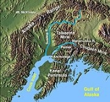
The Susitna River (Sasut Na’ in Ahtna
) is a 313 miles (503.7 km) long river
in the Southcentral Alaska. It is the 15th largest river in the United States of America, ranked by average discharge volume at its mouth. The river stretches from the Susitna Glacier
to Cook Inlet
.
Indian
name meaning "sandy river" published by the Russia
n Hydrog. Dept. as "R(eka) Sushitna," meaning Sushitna River, on Chart 1378 dated 1847. The Susitna River appears to have been first explored in 1834, by a "Creole
named Malakov", and the name may have been obtained by the Russians at that time. The present spelling of the name has evolved due to euphemistic reasons.
, flows southwest to Cook Inlet
, 24 miles (38.6 km) west of Anchorage, Alaska
Cook Inlet
Low.
There are several rivers flowing into the Susitna River including East Fork Susitna River and West Fork Susitna River. The Little Susitna River is a separate river system which flows into the Cook Inlet
on the other side of Susitna Flats.
The Susitna along with the Matanuska River
, drains the broad Matanuska-Susitna Valley
south of the Alaska Range
.
It rises in the Susitna Glacier
on Mount Hayes
in the Alaska Range
near 63°30′N 147°15′W. It flows in winding course generally southwest to Curry, then south, along the west side of the Talkeetna Mountains
, past Talkeetna
, Chulitna River, and Susitna
, and drains into Cook Inlet
approximately 25 miles (40 km) west of Anchorage
.
It receives the Yentna River
from the northwest approximately 5 miles (8 km) north of Susitna
. It is navigable to 85 mile (137 km) upstream from its mouth to Talkeetna
.
The Susitna River is one of Southcentral Alaska's premier sport fishing
streams, with significant runs of Chinook
and Coho salmon
, along with resident grayling
, burbot
, and rainbow trout
. Located within a roadless area, access to the river is difficult and is made usually by power boat or by floatplane.
Matanuska-Susitna Borough owns much of the land along the Susitna and Deshka River
s. The impacts of summer recreational use and tourists have caused loss of riparian vegetation
and bank erosion
along the Deshka River
's lower reaches, which has been partially remedied through a restoration project in the summer of 2002. However, the borough
currently lacks either regulations to prevent further damage or the means to enforce such regulations.
Alaska Native people meaning "sandy river". The Susitna appears to have been first explored in 1834 by a Creole
Indian
named Malakor. The 1890 census
reported that Susitna Village
on the east bank of the river had 146 Kenai
Natives and 27 houses.
22 miles (35.4 km) North-East of North Foreland
.
Mount Susitna
,
a prominent landmark along the upper part of the inlet,
is about 6 miles (10 km) West of the Susitna River at a point 13 miles (20.9 km) above the mouth.
(1330) The channels across the flats at the mouth of Susitna River have depths of 2 feet (609.6 mm) or less at low water and change during the winter and spring because of ice and freshet
action.
The channels above the mouth are said to change frequently in the spring and early summer.
(1331) Launches
navigate Susitna River to Yentna River
,
about 20 miles (32.2 km) above Cook Inlet
,
thence run occasionally up the Yentna River
to the forks about 65 miles (104.6 km) from the Susitna River.
The tides are not felt more than 7 miles (11.3 km) from the inlet,
and above this the current is swift.
Overhead power cables with a least clearance of 37 feet (11.3 m) cross the Susitna River about 5 miles (8 km) above its mouth.
(1332) Alexander, Alaska is a small settlement on the west side of Susitna River 10 miles (16.1 km) above the mouth.
Susitna, Alaska
is on the East side 18 miles (29 km) above the mouth and just below the mouth of the Yentna River
;
launches
run to and from Anchorage, Alaska
.
Mail is delivered to both settlements twice monthly by airplane from Anchorage, Alaska
.
(1333) Susitna Flats lies between big Susitna River and Little Susitna River and to the East of the latter.
Susitna Flats Light 61°15′10"N 150°29′17"W,
19 feet (5.8 m) above the water,
is shown from a skeleton tower and is equipped with a racon
.
(1334) Little Susitna River, 9 miles (14 km) West of Point MacKenzie,
is said to be navigable for landing craft
and skiff
s at high water
for about 8 miles (13 km).
(1335) Caution:
the depths offshore and in the approach to Little Susitna River are subject to drastic and continual change.
in south-central Alaska
. It spans the Susitna River
on the eastern edge of Denali State Park
near Gold Creek. The bridge is on the National Register of Historic Places
.
Construction of the bridge took place from October 1920 to February 1921. The span is 503 ft., with a height of 71 ft. in the center; the steel weighs 2,000 tons, and rests on two concrete piers, each 50 ft. high and 70 x 40 ft. in cross-section, and each containing 1,500 cubic yards of concrete. The location was chosen, just downstream of a curve, after observing the pattern of ice jams through the preceding three years.
Between April 12 and May 10 the ice breaks-up for the summer.
Ahtna language
Ahtna or Ahtena is the Na-Dené language of the Ahtna ethnic group of the Copper River area of Alaska. The language is also known as Copper River or Mednovskiy...
) is a 313 miles (503.7 km) long river
River
A river is a natural watercourse, usually freshwater, flowing towards an ocean, a lake, a sea, or another river. In a few cases, a river simply flows into the ground or dries up completely before reaching another body of water. Small rivers may also be called by several other names, including...
in the Southcentral Alaska. It is the 15th largest river in the United States of America, ranked by average discharge volume at its mouth. The river stretches from the Susitna Glacier
Susitna Glacier
Susitna Glacier is an alpine or valley glacier in the Alaska Range. Susitna Glacier flows over a seismically active area. The 7.9-magnitude 2002 Denali earthquake struck the region in November 2002. The earthquake initiated with thrust movement on the previously unrecognized Susitna Glacier fault ....
to Cook Inlet
Cook Inlet
Cook Inlet stretches from the Gulf of Alaska to Anchorage in south-central Alaska. Cook Inlet branches into the Knik Arm and Turnagain Arm at its northern end, almost surrounding Anchorage....
.
History
TanainaTanaina
Tanaina may refer to:*An Alaska Native ethnic group also known as Dena’ina*An Athabascan language of Alaska, also known as Dena'ina*Tanaina, Alaska, a census-designated place...
Indian
Native Americans in the United States
Native Americans in the United States are the indigenous peoples in North America within the boundaries of the present-day continental United States, parts of Alaska, and the island state of Hawaii. They are composed of numerous, distinct tribes, states, and ethnic groups, many of which survive as...
name meaning "sandy river" published by the Russia
Russia
Russia or , officially known as both Russia and the Russian Federation , is a country in northern Eurasia. It is a federal semi-presidential republic, comprising 83 federal subjects...
n Hydrog. Dept. as "R(eka) Sushitna," meaning Sushitna River, on Chart 1378 dated 1847. The Susitna River appears to have been first explored in 1834, by a "Creole
Creole peoples
The term Creole and its cognates in other languages — such as crioulo, criollo, créole, kriolu, criol, kreyol, kreol, kriulo, kriol, krio, etc. — have been applied to people in different countries and epochs, with rather different meanings...
named Malakov", and the name may have been obtained by the Russians at that time. The present spelling of the name has evolved due to euphemistic reasons.
Description
The Susitna River heads at Susitna Glacier, in Alaska RangeAlaska Range
The Alaska Range is a relatively narrow, 650-km-long mountain range in the southcentral region of the U.S. state of Alaska, from Lake Clark at its southwest end to the White River in Canada's Yukon Territory in the southeast...
, flows southwest to Cook Inlet
Cook Inlet
Cook Inlet stretches from the Gulf of Alaska to Anchorage in south-central Alaska. Cook Inlet branches into the Knik Arm and Turnagain Arm at its northern end, almost surrounding Anchorage....
, 24 miles (38.6 km) west of Anchorage, Alaska
Anchorage, Alaska
Anchorage is a unified home rule municipality in the southcentral part of the U.S. state of Alaska. It is the northernmost major city in the United States...
Cook Inlet
Cook Inlet
Cook Inlet stretches from the Gulf of Alaska to Anchorage in south-central Alaska. Cook Inlet branches into the Knik Arm and Turnagain Arm at its northern end, almost surrounding Anchorage....
Low.
There are several rivers flowing into the Susitna River including East Fork Susitna River and West Fork Susitna River. The Little Susitna River is a separate river system which flows into the Cook Inlet
Cook Inlet
Cook Inlet stretches from the Gulf of Alaska to Anchorage in south-central Alaska. Cook Inlet branches into the Knik Arm and Turnagain Arm at its northern end, almost surrounding Anchorage....
on the other side of Susitna Flats.
The Susitna along with the Matanuska River
Matanuska River
The Matanuska River is a river, approximately 75 miles long, in Southcentral Alaska, United States. It drains a broad valley south of the Alaska Range known as the Matanuska-Susitna Valley....
, drains the broad Matanuska-Susitna Valley
Matanuska-Susitna Valley
Matanuska-Susitna Valley is an area in Southcentral Alaska south of the Alaska Range about 35 miles north of Anchorage, Alaska....
south of the Alaska Range
Alaska Range
The Alaska Range is a relatively narrow, 650-km-long mountain range in the southcentral region of the U.S. state of Alaska, from Lake Clark at its southwest end to the White River in Canada's Yukon Territory in the southeast...
.
It rises in the Susitna Glacier
Susitna Glacier
Susitna Glacier is an alpine or valley glacier in the Alaska Range. Susitna Glacier flows over a seismically active area. The 7.9-magnitude 2002 Denali earthquake struck the region in November 2002. The earthquake initiated with thrust movement on the previously unrecognized Susitna Glacier fault ....
on Mount Hayes
Mount Hayes
Mount Hayes is the highest mountain in the eastern Alaska Range. Despite not being a fourteener, it is one of the largest peaks in the United States in terms of rise above local terrain. For example, the Northeast Face rises 8,000 feet in approximately 2 miles...
in the Alaska Range
Alaska Range
The Alaska Range is a relatively narrow, 650-km-long mountain range in the southcentral region of the U.S. state of Alaska, from Lake Clark at its southwest end to the White River in Canada's Yukon Territory in the southeast...
near 63°30′N 147°15′W. It flows in winding course generally southwest to Curry, then south, along the west side of the Talkeetna Mountains
Talkeetna Mountains
The Talkeetna Mountains are a mountain range in Alaska. The Matanuska and Susitna River valleys, with towns such as Trapper Creek, Talkeetna, Wasilla, Palmer, Sutton, and Chickaloon, roughly bound the Talkeetnas in the westerly parts of the range. Sovereign Mountain rises to 8849 feet in the...
, past Talkeetna
Talkeetna, Alaska
Talkeetna is a census-designated place in Matanuska-Susitna Borough, Alaska, United States. It is part of the Anchorage, Alaska Metropolitan Statistical Area. At the 2000 census the population was 772.-Geography:...
, Chulitna River, and Susitna
Susitna, Alaska
Susitna is a census-designated place in Matanuska-Susitna Borough, Alaska, United States. It is part of the Anchorage, Alaska Metropolitan Statistical Area...
, and drains into Cook Inlet
Cook Inlet
Cook Inlet stretches from the Gulf of Alaska to Anchorage in south-central Alaska. Cook Inlet branches into the Knik Arm and Turnagain Arm at its northern end, almost surrounding Anchorage....
approximately 25 miles (40 km) west of Anchorage
Anchorage, Alaska
Anchorage is a unified home rule municipality in the southcentral part of the U.S. state of Alaska. It is the northernmost major city in the United States...
.
It receives the Yentna River
Yentna River
The Yentna River is a river in South Central Alaska, formed by its East Fork and West Fork at , flows South-East to Susitna River, North-West of Anchorage, Alaska; Cook Inlet Low.- History :...
from the northwest approximately 5 miles (8 km) north of Susitna
Susitna, Alaska
Susitna is a census-designated place in Matanuska-Susitna Borough, Alaska, United States. It is part of the Anchorage, Alaska Metropolitan Statistical Area...
. It is navigable to 85 mile (137 km) upstream from its mouth to Talkeetna
Talkeetna, Alaska
Talkeetna is a census-designated place in Matanuska-Susitna Borough, Alaska, United States. It is part of the Anchorage, Alaska Metropolitan Statistical Area. At the 2000 census the population was 772.-Geography:...
.
The Susitna River is one of Southcentral Alaska's premier sport fishing
Fishing
Fishing is the activity of trying to catch wild fish. Fish are normally caught in the wild. Techniques for catching fish include hand gathering, spearing, netting, angling and trapping....
streams, with significant runs of Chinook
Chinook salmon
The Chinook salmon, Oncorhynchus tshawytscha, is the largest species in the pacific salmon family. Other commonly used names for the species include King salmon, Quinnat salmon, Spring salmon and Tyee salmon...
and Coho salmon
Coho salmon
The Coho salmon, Oncorhynchus kisutch, is a species of anadromous fish in the salmon family. Coho salmon are also known as silver salmon or "silvers". It is the state animal of Chiba, Japan.-Description:...
, along with resident grayling
Grayling (genus)
Thymallus is a genus of freshwater fish in the salmon family of order Salmoniformes; it is the only genus of subfamily Thymallinae. The type species is T. thymallus, the grayling. The genus's five distinct species are generically called graylings, but without qualification this also refers...
, burbot
Burbot
The burbot is the only gadiform fish inhabiting freshwaters. It is also known as mariah, the lawyer, and eelpout. It is closely related to the marine common ling and the cusk...
, and rainbow trout
Rainbow trout
The rainbow trout is a species of salmonid native to tributaries of the Pacific Ocean in Asia and North America. The steelhead is a sea run rainbow trout usually returning to freshwater to spawn after 2 to 3 years at sea. In other words, rainbow trout and steelhead trout are the same species....
. Located within a roadless area, access to the river is difficult and is made usually by power boat or by floatplane.
Matanuska-Susitna Borough owns much of the land along the Susitna and Deshka River
Deshka River
The Deshka River is a river in southern-central Alaska.The Deshka River is one of Southcentral Alaska's premier sport fishing streams, with significant runs of Chinook and coho salmon, along with resident grayling, burbot, northern pike, and rainbow trout...
s. The impacts of summer recreational use and tourists have caused loss of riparian vegetation
Vegetation
Vegetation is a general term for the plant life of a region; it refers to the ground cover provided by plants. It is a general term, without specific reference to particular taxa, life forms, structure, spatial extent, or any other specific botanical or geographic characteristics. It is broader...
and bank erosion
Erosion
Erosion is when materials are removed from the surface and changed into something else. It only works by hydraulic actions and transport of solids in the natural environment, and leads to the deposition of these materials elsewhere...
along the Deshka River
Deshka River
The Deshka River is a river in southern-central Alaska.The Deshka River is one of Southcentral Alaska's premier sport fishing streams, with significant runs of Chinook and coho salmon, along with resident grayling, burbot, northern pike, and rainbow trout...
's lower reaches, which has been partially remedied through a restoration project in the summer of 2002. However, the borough
Borough
A borough is an administrative division in various countries. In principle, the term borough designates a self-governing township although, in practice, official use of the term varies widely....
currently lacks either regulations to prevent further damage or the means to enforce such regulations.
Etymology
Susitna River was named by the Dena’inaDena’ina
The Dena'ina are an Alaska Native people, an extended tribe of American Indian lineage. They are the original inhabitants of the southcentral Alaska region ranging from Seldovia in the south to Chickaloon in the northeast, Talkeetna in the north, Lime Village in the Northwest and Pedro Bay in the...
Alaska Native people meaning "sandy river". The Susitna appears to have been first explored in 1834 by a Creole
Creole peoples
The term Creole and its cognates in other languages — such as crioulo, criollo, créole, kriolu, criol, kreyol, kreol, kriulo, kriol, krio, etc. — have been applied to people in different countries and epochs, with rather different meanings...
Indian
Native Americans in the United States
Native Americans in the United States are the indigenous peoples in North America within the boundaries of the present-day continental United States, parts of Alaska, and the island state of Hawaii. They are composed of numerous, distinct tribes, states, and ethnic groups, many of which survive as...
named Malakor. The 1890 census
Census
A census is the procedure of systematically acquiring and recording information about the members of a given population. It is a regularly occurring and official count of a particular population. The term is used mostly in connection with national population and housing censuses; other common...
reported that Susitna Village
Susitna, Alaska
Susitna is a census-designated place in Matanuska-Susitna Borough, Alaska, United States. It is part of the Anchorage, Alaska Metropolitan Statistical Area...
on the east bank of the river had 146 Kenai
Kenai
-Places:* Kenai, Alaska, a city in Kenai Peninsula Borough, Alaska* Kenai Peninsula, a large peninsula in south-central Alaska* Kenai River, a river on the Kenai Peninsula* Kenai Mountains, a mountain range in Alaska* Kenai Fjords National Park...
Natives and 27 houses.
Location
(1329) Susitna River is on the North side of Cook InletCook Inlet
Cook Inlet stretches from the Gulf of Alaska to Anchorage in south-central Alaska. Cook Inlet branches into the Knik Arm and Turnagain Arm at its northern end, almost surrounding Anchorage....
22 miles (35.4 km) North-East of North Foreland
North Foreland
North Foreland is a chalk headland on the Kent coast of southeast England.North Foreland forms the eastern end of the Isle of Thanet. It presents a bold cliff to the sea, and commands views over the southern North Sea.-Lighthouse:...
.
Mount Susitna
Mount Susitna
Mount Susitna is a mountain in the U.S. state of Alaska. It is located on the west bank of the lower Susitna River, about northwest of Anchorage, Alaska...
,
a prominent landmark along the upper part of the inlet,
is about 6 miles (10 km) West of the Susitna River at a point 13 miles (20.9 km) above the mouth.
(1330) The channels across the flats at the mouth of Susitna River have depths of 2 feet (609.6 mm) or less at low water and change during the winter and spring because of ice and freshet
Freshet
A freshet can refer to one of two things:* A flood resulting from heavy rain or a spring thaw. Whereas heavy rain often causes a flash flood, a spring thaw event is generally a more incremental process, depending upon local climate and topography...
action.
The channels above the mouth are said to change frequently in the spring and early summer.
(1331) Launches
Launch (boat)
A launch in contemporary usage refers to a large motorboat. The name originally referred to the largest boat carried by a warship. The etymology of the word is given as Portuguese lancha "barge", from Malay lancha, lancharan, "boat," from lanchar "velocity without effort," "action of gliding...
navigate Susitna River to Yentna River
Yentna River
The Yentna River is a river in South Central Alaska, formed by its East Fork and West Fork at , flows South-East to Susitna River, North-West of Anchorage, Alaska; Cook Inlet Low.- History :...
,
about 20 miles (32.2 km) above Cook Inlet
Cook Inlet
Cook Inlet stretches from the Gulf of Alaska to Anchorage in south-central Alaska. Cook Inlet branches into the Knik Arm and Turnagain Arm at its northern end, almost surrounding Anchorage....
,
thence run occasionally up the Yentna River
Yentna River
The Yentna River is a river in South Central Alaska, formed by its East Fork and West Fork at , flows South-East to Susitna River, North-West of Anchorage, Alaska; Cook Inlet Low.- History :...
to the forks about 65 miles (104.6 km) from the Susitna River.
The tides are not felt more than 7 miles (11.3 km) from the inlet,
and above this the current is swift.
Overhead power cables with a least clearance of 37 feet (11.3 m) cross the Susitna River about 5 miles (8 km) above its mouth.
(1332) Alexander, Alaska is a small settlement on the west side of Susitna River 10 miles (16.1 km) above the mouth.
Susitna, Alaska
Susitna, Alaska
Susitna is a census-designated place in Matanuska-Susitna Borough, Alaska, United States. It is part of the Anchorage, Alaska Metropolitan Statistical Area...
is on the East side 18 miles (29 km) above the mouth and just below the mouth of the Yentna River
Yentna River
The Yentna River is a river in South Central Alaska, formed by its East Fork and West Fork at , flows South-East to Susitna River, North-West of Anchorage, Alaska; Cook Inlet Low.- History :...
;
launches
Launch (boat)
A launch in contemporary usage refers to a large motorboat. The name originally referred to the largest boat carried by a warship. The etymology of the word is given as Portuguese lancha "barge", from Malay lancha, lancharan, "boat," from lanchar "velocity without effort," "action of gliding...
run to and from Anchorage, Alaska
Anchorage, Alaska
Anchorage is a unified home rule municipality in the southcentral part of the U.S. state of Alaska. It is the northernmost major city in the United States...
.
Mail is delivered to both settlements twice monthly by airplane from Anchorage, Alaska
Anchorage, Alaska
Anchorage is a unified home rule municipality in the southcentral part of the U.S. state of Alaska. It is the northernmost major city in the United States...
.
(1333) Susitna Flats lies between big Susitna River and Little Susitna River and to the East of the latter.
Susitna Flats Light 61°15′10"N 150°29′17"W,
19 feet (5.8 m) above the water,
is shown from a skeleton tower and is equipped with a racon
Racon
A racon is a radar transponder commonly used to mark maritime navigational hazards. The word is a portmanteau of RAdar and beaCON.When a racon receives a radar pulse, it responds with a signal on the same frequency which puts an image on the radar display...
.
(1334) Little Susitna River, 9 miles (14 km) West of Point MacKenzie,
is said to be navigable for landing craft
Landing craft
Landing craft are boats and seagoing vessels used to convey a landing force from the sea to the shore during an amphibious assault. Most renowned are those used to storm the beaches of Normandy, the Mediterranean, and many Pacific islands during WWII...
and skiff
Skiff
The term skiff is used for a number of essentially unrelated styles of small boat. The word is related to ship and has a complicated etymology: "skiff" comes from the Middle English skif, which derives from the Old French esquif, which in turn derives from the Old Italian schifo, which is itself of...
s at high water
High Water
High Water is an album by hip hop artist El-P, released on March 9, 2004 through Thirsty Ear Recordings.Made in conjunction with jazz pianist Matthew Shipp and the group for which he is artistic director, The Blue Series Continuum, the album is a striking departure from El-P's usual style, almost...
for about 8 miles (13 km).
(1335) Caution:
the depths offshore and in the approach to Little Susitna River are subject to drastic and continual change.
Bridges
The Susitna River Bridge is a railroad bridge of the Alaska RailroadAlaska Railroad
The Alaska Railroad is a Class II railroad which extends from Seward and Whittier, in the south of the state of Alaska, in the United States, to Fairbanks , and beyond to Eielson Air Force Base and Fort Wainwright in the interior of that state...
in south-central Alaska
Alaska
Alaska is the largest state in the United States by area. It is situated in the northwest extremity of the North American continent, with Canada to the east, the Arctic Ocean to the north, and the Pacific Ocean to the west and south, with Russia further west across the Bering Strait...
. It spans the Susitna River
Susitna River
The Susitna River is a long river in the Southcentral Alaska. It is the 15th largest river in the United States of America, ranked by average discharge volume at its mouth. The river stretches from the Susitna Glacier to Cook Inlet....
on the eastern edge of Denali State Park
Denali State Park
Denali State Park is a state park in the U.S. state of Alaska. It is located adjacent in the Matanuska-Susitna Borough to the east side of Denali National Park and Preserve, along the Parks Highway....
near Gold Creek. The bridge is on the National Register of Historic Places
National Register of Historic Places
The National Register of Historic Places is the United States government's official list of districts, sites, buildings, structures, and objects deemed worthy of preservation...
.
Construction of the bridge took place from October 1920 to February 1921. The span is 503 ft., with a height of 71 ft. in the center; the steel weighs 2,000 tons, and rests on two concrete piers, each 50 ft. high and 70 x 40 ft. in cross-section, and each containing 1,500 cubic yards of concrete. The location was chosen, just downstream of a curve, after observing the pattern of ice jams through the preceding three years.
Ice
Between approximately October 19 and November 14 the Susitna River ices or freezes over for the winter.Between April 12 and May 10 the ice breaks-up for the summer.
Tributaries
- East Fork Susitna River
- West Fork Susitna River
- Yentna RiverYentna RiverThe Yentna River is a river in South Central Alaska, formed by its East Fork and West Fork at , flows South-East to Susitna River, North-West of Anchorage, Alaska; Cook Inlet Low.- History :...
- Deshka RiverDeshka RiverThe Deshka River is a river in southern-central Alaska.The Deshka River is one of Southcentral Alaska's premier sport fishing streams, with significant runs of Chinook and coho salmon, along with resident grayling, burbot, northern pike, and rainbow trout...
- Talkeetna RiverTalkeetna RiverThe Talkeetna River is a river in Alaska.-History:Tanaina Indian name reported in 1898 to mean "river of plenty" by G. H...
- Chulitna River
- Oshetna River
- Tyone River
- Maclaren River