
Suffolk Coast and Heaths AONB
Encyclopedia
The Suffolk Coast and Heaths AONB is an Area of Outstanding Natural Beauty
in Suffolk
, England.
The AONB covers ancient woodland, commercial forestry, the estuaries of the Alde
, Blyth
, Deben, Orwell
and Stour
rivers, farmland, salt marsh
, heathland, mudflats, reed bed
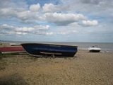
s, small towns and villages, shingle beach
es and low eroding cliffs along 60 miles of coastline.
Features include the coastal towns of Aldeburgh
and Southwold
. Bawdsey
, Covehithe
, Dunwich
, Minsmere
, Orford
, Orford Ness
, Sizewell
, Thorpeness
, Walberswick
and the RSPB Minsmere
Reserve. There are three National Nature Reserves in the area and many Sites of Special Scientific Interest. Three long distance footpaths pass through the AONB: the Suffolk Coast Path, the Sandlings Walk
and the Stour and Orwell Walk.
Area of Outstanding Natural Beauty
An Area of Outstanding Natural Beauty is an area of countryside considered to have significant landscape value in England, Wales or Northern Ireland, that has been specially designated by the Countryside Agency on behalf of the United Kingdom government; the Countryside Council for Wales on...
in Suffolk
Suffolk
Suffolk is a non-metropolitan county of historic origin in East Anglia, England. It has borders with Norfolk to the north, Cambridgeshire to the west and Essex to the south. The North Sea lies to the east...
, England.
The AONB covers ancient woodland, commercial forestry, the estuaries of the Alde
River Alde
The River Alde is a river in Suffolk, England, with a source near Laxfield in the same area as the River Blyth. Initially a stream, it becomes tidal and widens considerably when it reaches Snape. It meanders east past Aldeburgh, after which this part of the river was named...
, Blyth
River Blyth, Suffolk
The River Blyth is a river in Suffolk, England, with a tidal estuary between Southwold and Walberswick.It can be crossed by pedestrians by a public footbridge called the Bailey Bridge about a mile upstream from the sea or by the Walberswick rowing boat ferry between 9am-5pm daily.The estuary mouth...
, Deben, Orwell
River Orwell
The River Orwell flows through the county of Suffolk in England. Its source river, above the tidal limit at Stoke Bridge, is known as the River Gipping. It broadens into an estuary at Ipswich where the Ipswich dock has operated since the 7th century and then flows into the North Sea at Felixstowe...
and Stour
River Stour, Suffolk
The River Stour is a river in East Anglia, England. It is 76 km long and forms most of the county boundary between Suffolk to the north, and Essex to the south. It rises in eastern Cambridgeshire, passes to the east of Haverhill, through Cavendish, Sudbury and the Dedham Vale, and joins the...
rivers, farmland, salt marsh
Salt marsh
A salt marsh is an environment in the upper coastal intertidal zone between land and salt water or brackish water, it is dominated by dense stands of halophytic plants such as herbs, grasses, or low shrubs. These plants are terrestrial in origin and are essential to the stability of the salt marsh...
, heathland, mudflats, reed bed
Reed bed
Reed beds are natural habitats found in floodplains, waterlogged depressions andestuaries. Reed beds are part of a succession from young reed colonising open water or wet ground through a gradation of increasingly dry ground...
s, small towns and villages, shingle beach
Shingle beach
A shingle beach is a beach which is armoured with pebbles or small- to medium-sized cobbles. Typically, the stone composition may grade from characteristic sizes ranging from two to 200 mm diameter....
es and low eroding cliffs along 60 miles of coastline.
Features include the coastal towns of Aldeburgh
Aldeburgh
Aldeburgh is a coastal town in Suffolk, East Anglia, England. Located on the River Alde, the town is notable for its Blue Flag shingle beach and fisherman huts where freshly caught fish are sold daily, and the Aldeburgh Yacht Club...
and Southwold
Southwold
Southwold is a town on the North Sea coast, in the Waveney district of the English county of Suffolk. It is located on the North Sea coast at the mouth of the River Blyth within the Suffolk Coast and Heaths Area of Outstanding Natural Beauty. The town is around south of Lowestoft and north-east...
. Bawdsey
Bawdsey
Bawdsey is a village and civil parish in Suffolk, eastern England. Located near Felixstowe, it had an estimated population of 340 in 2007.Bawdsey Manor is notable as the place where radar research took place early in World War II, before moving to Worth Matravers, which is four miles to the west of...
, Covehithe
Covehithe
Covehithe, formerly North Hales, is a hamlet in a parish in Blything district, Suffolk, England. Lying on the coast around North-east of Southwold,also 8 miles South from the town of Lowestoft...
, Dunwich
Dunwich
Dunwich is a small town in Suffolk, England, within the Suffolk Coast and Heaths AONB.Dunwich was the capital of East Anglia 1500 years ago but the harbour and most of the town have since disappeared due to coastal erosion. Its decline began in 1286 when a sea surge hit the East Anglian coast, and...
, Minsmere
Minsmere
Minsmere is a hamlet on the Suffolk coast a couple of miles south of Dunwich, within the Suffolk Coast and Heaths AONB.Ranulf de Glanvill built an abbey on the marshes here in the 12th century, but this was abandoned in favour of Leiston Abbey in 1363...
, Orford
Orford, Suffolk
Orford is a small town in Suffolk, England, within the Suffolk Coast and Heaths AONB.Like many Suffolk coastal towns it was of some importance as a port and fishing village in the Middle Ages. It still has a fine mediaeval castle, built to dominate the River Ore.The main geographical feature of the...
, Orford Ness
Orford Ness
Orford Ness is a cuspate foreland shingle spit on the Suffolk coast in Great Britain, linked to the mainland at Aldeburgh and stretching along the coast to Orford and down to North Wier Point, opposite Shingle Street. It is divided from the mainland by the River Alde, and was formed by longshore...
, Sizewell
Sizewell
Sizewell is a small fishing village with a few holiday homes in the county of Suffolk, England. It is located on the East Anglian coast just north of the larger holiday villages of Thorpeness and Aldeburgh, and two miles from the town of Leiston. It is within the Suffolk Coast and Heaths AONB.The...
, Thorpeness
Thorpeness
Thorpeness is a village in the county of Suffolk, England. It is part of the parish of Aldringham cum Thorpe and is within the Suffolk Coast and Heaths AONB.- Development of the community :...
, Walberswick
Walberswick
Walberswick is a village on the Suffolk coast in England, across the River Blyth from Southwold. Coastal erosion and the shifting of the mouth of the River Blyth meant that the neighbouring town of Dunwich was lost as a port in the last years of the 13th century...
and the RSPB Minsmere
RSPB Minsmere
Minsmere RSPB reserve is a nature reserve owned and run by the Royal Society for the Protection of Birds in Suffolk, England. It lies on the Suffolk coast to the south of Southwold and north of Aldeburgh within the Suffolk Coast and Heaths Area of Outstanding Natural Beauty and the Suffolk...
Reserve. There are three National Nature Reserves in the area and many Sites of Special Scientific Interest. Three long distance footpaths pass through the AONB: the Suffolk Coast Path, the Sandlings Walk
Sandlings Walk
The Sandlings Walk is a long-distance path in Suffolk, England. It runs through an area of lowland heath, Britain's rarest wildlife habitat, and the Suffolk Coast and Heaths Area of Outstanding Natural Beauty....
and the Stour and Orwell Walk.
See also
- Suffolk Coast Path