
Stony Clove Notch
Encyclopedia
Stony Clove Notch is a narrow pass
, roughly 2,220 feet (677 m) in elevation located in the Town of Hunter
in Greene County
, New York
, deep in the Catskill Mountains
. It is traversed by New York State Route 214
, although in the past the Ulster and Delaware Railroad
went through it as well.
The notch divides Hunter
and Plateau mountain
s. There is just enough room for the road, and the steep, soaring slopes of both mountains are some of the Catskills' most striking scenery, with landslides and rocky cliffs visible. It sits at one end of the range of mountains known as the Devil's Path
, and early visitors found it a terrifying place to visit.
Today it is a popular destination not only for tourists
in the region but for outdoor recreationists as well. One of the Catskills' major hiking
trail
s crosses the road near the notch, and ice climbers
and snowboard
ers have lately been attracted to the cliffs and slopes in winter.
, when meltwater that had accumulated in what is now the Schoharie
headlands to the north of the notch gradually began eroding
its way through the gap between the mountains, eventually becoming the Stony Clove Creek
. As painter and writer Charles Lanman
said in the 1840s:
Catskill historian Alf Evers
suggests that those interested in getting an idea of what Stony Clove Notch was like before the construction of the roads visit nearby Diamond Notch, where it is still possible to put one foot on Southwest Hunter Mountain
and another on West Kill Mountain
.
A few years later, at great expense, the route through the notch was widened to allow enough room for a single wagon by Charles Edwards, a local tanner
. Later excavations allowed the Stony Clove and Catskill Mountain Railroad to build a narrow gauge rail line through the gap. It was later upgraded to standard gauge and used until 1940, with a flagstop Stony Clove Notch Railroad Station
located nearby. The railbed remains visible in the woods to the east almost all the way to the height of land.
The Stoney Clove Turnpike was a private company that incorporated in 1873 to upgrade and improve the existing wagon road. It eventually became today's Route 214.
and Esopus
watershed
s.
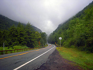 The approach from the Schoharie to the north, where the two mountains can be seen from 214's junction with Route 23A
, is characterized by a steady upward climb after the creek has been crossed, the two mountains seeming more and more immense until they just about swallow the road. Evers recommends coming this way when thunderstorm
s are brewing to the south if one wishes to understand attitudes such as Lanman's. "Lightning
and thunder
will be tossed back and forth from one mountain to the other," he writes. "And it will not be hard for a man with a normal amount of imagination to put himself in the place of his ancestors and see the Stony Clove transformed into the very gates of Hell."
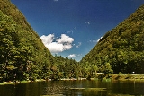
From the south, via Phoenicia
, the approach up Stony Clove has less drama, since Hunter and Plateau are not visible until the notch is considerably closer. However, it offers much sylvan scenery, winding along Stony Clove Creek
as it gradually gets higher and higher. Finally, at the Devil's Tombstone public campground it straightens out and the notch becomes apparent as it sweeps by Notch Pond and up to the height of land.
and red spruce
can be seen along the west (Hunter) side of the road from the pond up into the notch. Scrubby paper birch
, also common to boreal forests, is the dominant deciduous species on the Plateau side.
Most of the lands around the notch are protected area
s of the Catskill Park portion of New York's Forest Preserve
. The Plateau lands are the western end of the Indian Head Wilderness Area; Hunter's are currently classified a step lower, as the Hunter Mountain Wild Forest, though a pending update to the Catskill State Land Master Plan would combine it with other properties to classify it, too, as wilderness.
crosses the road (the only road crossing in its entire 24.2-mile (39 km) length). Most are bound for one of the three High Peaks in the area: Plateau, Hunter and Southwest Hunter
. Potable water is available for hikers and people using the day-use facilities from several pumps next to the parking lot.
The climb up Plateau offers the best chance to appreciate just how stark the notch is. After crossing the old railbed, the trail begins a steady ascent of 1,400 vertical feet (427 m) to the popular Orchard Point lookout, which offers a view across the notch to all the nearby peaks plus West Kill Mountain
beyond Southwest Hunter. From there it is two miles (3.2 km) across the aptly named Plateau to the mountain's actual summit.
To the west, the ascent is not so severe, although there are some steep sections, most famously near a ledge lower down on the trail called the Devil's Portal. There are no views, although there is a nice level section traversing along the back of Hunter to the Devil's Acre Lean-to, where the Hunter Mountain Trail leads to the top of the Catskills' second-highest peak. The Acre is also the beginning of the sometimes-difficult bushwhack to Southwest Hunter.
Currently, the Long Path
long-distance trail joins the Devil's Path here for the trip up Plateau after a two-mile (3 km) roadwalk. Future plans will relocate it into the deep forest, far from the highway.
In winter, ice climbers can also be found here seeking thrills on the cliffs on the Plateau side via a short hike; climbing is not otherwise done much in the Catskills due to the loose sedimentary rock
of the region. Snowboarders have also found the slope offers challenging wilderness runs.
Hunters have also come in-season, although the topography can make the area fatally dangerous. In fall 2000 a local high school teacher was found dead after having fallen off one of the cliffs on the Hunter side during a hunt.
Mountain pass
A mountain pass is a route through a mountain range or over a ridge. If following the lowest possible route, a pass is locally the highest point on that route...
, roughly 2,220 feet (677 m) in elevation located in the Town of Hunter
Hunter (town), New York
Hunter is a town in Greene County, New York. The population was 2,732 at the 2010 census.The Town of Hunter contain two villages one named Hunter and the other called Tannersville. The town is on the County's south border.- History :...
in Greene County
Greene County, New York
Greene County is a county located in the U.S. state of New York. Its name is in honor of the American Revolutionary War general Nathanael Greene. Its county seat is Catskill...
, New York
New York
New York is a state in the Northeastern region of the United States. It is the nation's third most populous state. New York is bordered by New Jersey and Pennsylvania to the south, and by Connecticut, Massachusetts and Vermont to the east...
, deep in the Catskill Mountains
Catskill Mountains
The Catskill Mountains, an area in New York State northwest of New York City and southwest of Albany, are a mature dissected plateau, an uplifted region that was subsequently eroded into sharp relief. They are an eastward continuation, and the highest representation, of the Allegheny Plateau...
. It is traversed by New York State Route 214
New York State Route 214
New York State Route 214 is a short but scenic state highway in the heart of the Catskill Park. It runs north–south from near the hamlet of Phoenicia up near an old railroad route into the narrow pass known as Stony Clove Notch, then down into the upper Schoharie Creek valley to end...
, although in the past the Ulster and Delaware Railroad
Ulster and Delaware Railroad
The Ulster and Delaware Railroad Company was a Class I railroad located in New York State, headquartered in Rondout and founded in 1866. It was often advertised as "The Only All-Rail Route To the Catskill Mountains." At its greatest extent, the U&D ran from Kingston Point, on the Hudson River,...
went through it as well.
The notch divides Hunter
Hunter Mountain (New York)
Hunter Mountain is in the towns of Hunter and Lexington, just south of the village of Hunter, in Greene County, New York, USA. At approximately 4,040 feet in elevation, it is the highest peak in the county and the second-highest peak in the Catskill Mountains.While the mountain is closely...
and Plateau mountain
Mountain
Image:Himalaya_annotated.jpg|thumb|right|The Himalayan mountain range with Mount Everestrect 58 14 160 49 Chomo Lonzorect 200 28 335 52 Makalurect 378 24 566 45 Mount Everestrect 188 581 920 656 Tibetan Plateaurect 250 406 340 427 Rong River...
s. There is just enough room for the road, and the steep, soaring slopes of both mountains are some of the Catskills' most striking scenery, with landslides and rocky cliffs visible. It sits at one end of the range of mountains known as the Devil's Path
Devil's Path (Catskills)
The Devil's Path is the name of a mountain range and hiking trail in the Greene County portion of New York's Catskill Mountains. The mountains commonly considered to be part of the Devil's Path are, from west to east, West Kill, Hunter, Plateau, Sugarloaf, Twin, and Indian Head.The name comes from...
, and early visitors found it a terrifying place to visit.
Today it is a popular destination not only for tourists
Tourism
Tourism is travel for recreational, leisure or business purposes. The World Tourism Organization defines tourists as people "traveling to and staying in places outside their usual environment for not more than one consecutive year for leisure, business and other purposes".Tourism has become a...
in the region but for outdoor recreationists as well. One of the Catskills' major hiking
Hiking
Hiking is an outdoor activity which consists of walking in natural environments, often in mountainous or other scenic terrain. People often hike on hiking trails. It is such a popular activity that there are numerous hiking organizations worldwide. The health benefits of different types of hiking...
trail
Trail
A trail is a path with a rough beaten or dirt/stone surface used for travel. Trails may be for use only by walkers and in some places are the main access route to remote settlements...
s crosses the road near the notch, and ice climbers
Ice climbing
Ice climbing, as the term indicates, is the activity of ascending inclined ice formations. Usually, ice climbing refers to roped and protected climbing of features such as icefalls, frozen waterfalls, and cliffs and rock slabs covered with ice refrozen from flows of water. For the purposes of...
and snowboard
Snowboard
Snowboards are boards, usually with a width the length of one's foot, with the ability to glide on snow. Snowboards are differentiated from monoskis by the stance of the user...
ers have lately been attracted to the cliffs and slopes in winter.
Natural origins
Stony Clove Notch was created during the end of the last Ice AgeWisconsin glaciation
The last glacial period was the most recent glacial period within the current ice age occurring during the last years of the Pleistocene, from approximately 110,000 to 10,000 years ago....
, when meltwater that had accumulated in what is now the Schoharie
Schoharie Creek
Schoharie Creek in New York, USA flows north from the foot of Indian Head Mountain in the Catskill Mountains through the Schoharie Valley to the Mohawk River. It is twice impounded north of Prattsville to create New York City's Schoharie Reservoir and the Blenheim-Gilboa Power Project.Two notable...
headlands to the north of the notch gradually began eroding
Erosion
Erosion is when materials are removed from the surface and changed into something else. It only works by hydraulic actions and transport of solids in the natural environment, and leads to the deposition of these materials elsewhere...
its way through the gap between the mountains, eventually becoming the Stony Clove Creek
Stony Clove Creek
Stony Clove Creek is a creek in the Catskill Mountains in New York. It is a tributary of Esopus Creek, which in turn is a tributary of the Hudson River. It joins the Esopus in the village of Phoenicia, and has two smaller tributaries up north of Phoenicia....
Human use
When the first Europeans were taken through the notch, it was narrow enough that not only was travel through it possible only on foot, those travelers had to go through in single fileFile (formation)
A file is a military term for a number of troops drawn up in line ahead, i.e. one behind the other in a column. The number of files is the measure of the width of a formation of troops in several ranks one behind the other.- Ancient Greek use :...
. As painter and writer Charles Lanman
Charles Lanman
Charles Lanman was an author, government official, artist, librarian, and explorer.-Early life and education:Charles Lanman was born at Monroe, Michigan, on June 14, 1819, the son of Charles James Lanman, and the grandson of United States Senator James Lanman...
said in the 1840s:
Catskill historian Alf Evers
Alf Evers
Alf Evers , was an American historian who lived in Ulster County, New York for much of his life and wrote lengthy, definitive histories of the Catskills and Woodstock, serving the latter as town historian...
suggests that those interested in getting an idea of what Stony Clove Notch was like before the construction of the roads visit nearby Diamond Notch, where it is still possible to put one foot on Southwest Hunter Mountain
Southwest Hunter Mountain
Southwest Hunter Mountain is a subpeak of Hunter Mountain, located in Greene County, New York.SW Hunter is considered one of the Catskills' High Peaks in its own right, because of its separation from the main summit, and its topographic prominence.Hunter Mountain is named after John Hunter, who...
and another on West Kill Mountain
West Kill Mountain
West Kill Mountain, or Westkill Mountain, is located in Greene County, New York.The mountain is named after the West Kill stream which flows along its northern side, and is part of the Devil's Path range of the Catskill Mountains....
.
A few years later, at great expense, the route through the notch was widened to allow enough room for a single wagon by Charles Edwards, a local tanner
Tanning
Tanning is the making of leather from the skins of animals which does not easily decompose. Traditionally, tanning used tannin, an acidic chemical compound from which the tanning process draws its name . Coloring may occur during tanning...
. Later excavations allowed the Stony Clove and Catskill Mountain Railroad to build a narrow gauge rail line through the gap. It was later upgraded to standard gauge and used until 1940, with a flagstop Stony Clove Notch Railroad Station
Stony Clove Notch Railroad Station
This Ulster and Delaware station, branch MP 9.8, was at the summit of a grade that went to the Stony Clove Notch, where the Stony Clove Valley came to a pinch, and was but a few yards wide. It was a flagstop, where people would have to signal a train to stop for them. This station never made much...
located nearby. The railbed remains visible in the woods to the east almost all the way to the height of land.
The Stoney Clove Turnpike was a private company that incorporated in 1873 to upgrade and improve the existing wagon road. It eventually became today's Route 214.
Geography
The notch divides the SchoharieSchoharie Creek
Schoharie Creek in New York, USA flows north from the foot of Indian Head Mountain in the Catskill Mountains through the Schoharie Valley to the Mohawk River. It is twice impounded north of Prattsville to create New York City's Schoharie Reservoir and the Blenheim-Gilboa Power Project.Two notable...
and Esopus
Esopus Creek
Esopus Creek is a tributary of the Hudson River that drains the east-central Catskill Mountains of the U.S. state of New York. From its source at Winnisook Lake on the slopes of Slide Mountain, the Catskills' highest peak, it flows across Ulster County to the Hudson at Saugerties. Many tributaries...
watershed
Drainage basin
A drainage basin is an extent or an area of land where surface water from rain and melting snow or ice converges to a single point, usually the exit of the basin, where the waters join another waterbody, such as a river, lake, reservoir, estuary, wetland, sea, or ocean...
s.
New York State Route 23A
New York State Route 23A is an east–west state highway in Greene County, New York, in the United States. It serves as a alternate route of NY 23 through the northern Catskill Mountains...
, is characterized by a steady upward climb after the creek has been crossed, the two mountains seeming more and more immense until they just about swallow the road. Evers recommends coming this way when thunderstorm
Thunderstorm
A thunderstorm, also known as an electrical storm, a lightning storm, thundershower or simply a storm is a form of weather characterized by the presence of lightning and its acoustic effect on the Earth's atmosphere known as thunder. The meteorologically assigned cloud type associated with the...
s are brewing to the south if one wishes to understand attitudes such as Lanman's. "Lightning
Lightning
Lightning is an atmospheric electrostatic discharge accompanied by thunder, which typically occurs during thunderstorms, and sometimes during volcanic eruptions or dust storms...
and thunder
Thunder
Thunder is the sound made by lightning. Depending on the nature of the lightning and distance of the listener, thunder can range from a sharp, loud crack to a long, low rumble . The sudden increase in pressure and temperature from lightning produces rapid expansion of the air surrounding and within...
will be tossed back and forth from one mountain to the other," he writes. "And it will not be hard for a man with a normal amount of imagination to put himself in the place of his ancestors and see the Stony Clove transformed into the very gates of Hell."
From the south, via Phoenicia
Phoenicia, New York
Phoenicia is a hamlet in Ulster County, New York, United States. The population was 381 at the 2000 census.Phoenicia is located in the northeast part of Town of Shandaken, on Route 28. It is the largest community in the town...
, the approach up Stony Clove has less drama, since Hunter and Plateau are not visible until the notch is considerably closer. However, it offers much sylvan scenery, winding along Stony Clove Creek
Stony Clove Creek
Stony Clove Creek is a creek in the Catskill Mountains in New York. It is a tributary of Esopus Creek, which in turn is a tributary of the Hudson River. It joins the Esopus in the village of Phoenicia, and has two smaller tributaries up north of Phoenicia....
as it gradually gets higher and higher. Finally, at the Devil's Tombstone public campground it straightens out and the notch becomes apparent as it sweeps by Notch Pond and up to the height of land.
Environment
The notch is noteworthy as one of the few locations in the Catskills where boreal forest occurs below 3,000 feet (914 m) in elevation. Forest fires in 1893 which destroyed 3,000 acres (12 km²) around the notch, mostly on the Plateau side, and the steep terrain have left depleted, thin soils where balsam firBalsam Fir
The balsam fir is a North American fir, native to most of eastern and central Canada and the northeastern United States .-Growth:It is a small to medium-size evergreen tree typically tall, rarely to tall, with a narrow conic crown...
and red spruce
Red Spruce
Picea rubens is a species of spruce native to eastern North America, ranging from eastern Quebec to Nova Scotia, and from New England south in the Adirondack Mountains and Appalachians to western North Carolina.-Physical description:...
can be seen along the west (Hunter) side of the road from the pond up into the notch. Scrubby paper birch
Paper Birch
Betula papyrifera is a species of birch native to northern North America.-Description:...
, also common to boreal forests, is the dominant deciduous species on the Plateau side.
Most of the lands around the notch are protected area
Protected area
Protected areas are locations which receive protection because of their recognised natural, ecological and/or cultural values. There are several kinds of protected areas, which vary by level of protection depending on the enabling laws of each country or the regulations of the international...
s of the Catskill Park portion of New York's Forest Preserve
Forest Preserve (New York)
New York's Forest Preserve is all the land owned by the state within the Adirondack and Catskill parks, managed by its Department of Environmental Conservation. These properties are required to be kept "forever wild" by Article 14 of the state constitution, and thus enjoy the highest degree of...
. The Plateau lands are the western end of the Indian Head Wilderness Area; Hunter's are currently classified a step lower, as the Hunter Mountain Wild Forest, though a pending update to the Catskill State Land Master Plan would combine it with other properties to classify it, too, as wilderness.
Recreation
A medium-sized parking lot sits next to Notch Pond just below the notch, right where the popular Devil's Path hiking trailDevil's Path (hiking trail)
The Devil's Path is a hiking trail in the Greene County section of the Catskill Mountains of New York, often described as the toughest hiking trail in the Eastern United States...
crosses the road (the only road crossing in its entire 24.2-mile (39 km) length). Most are bound for one of the three High Peaks in the area: Plateau, Hunter and Southwest Hunter
Southwest Hunter Mountain
Southwest Hunter Mountain is a subpeak of Hunter Mountain, located in Greene County, New York.SW Hunter is considered one of the Catskills' High Peaks in its own right, because of its separation from the main summit, and its topographic prominence.Hunter Mountain is named after John Hunter, who...
. Potable water is available for hikers and people using the day-use facilities from several pumps next to the parking lot.
The climb up Plateau offers the best chance to appreciate just how stark the notch is. After crossing the old railbed, the trail begins a steady ascent of 1,400 vertical feet (427 m) to the popular Orchard Point lookout, which offers a view across the notch to all the nearby peaks plus West Kill Mountain
West Kill Mountain
West Kill Mountain, or Westkill Mountain, is located in Greene County, New York.The mountain is named after the West Kill stream which flows along its northern side, and is part of the Devil's Path range of the Catskill Mountains....
beyond Southwest Hunter. From there it is two miles (3.2 km) across the aptly named Plateau to the mountain's actual summit.
To the west, the ascent is not so severe, although there are some steep sections, most famously near a ledge lower down on the trail called the Devil's Portal. There are no views, although there is a nice level section traversing along the back of Hunter to the Devil's Acre Lean-to, where the Hunter Mountain Trail leads to the top of the Catskills' second-highest peak. The Acre is also the beginning of the sometimes-difficult bushwhack to Southwest Hunter.
Currently, the Long Path
Long Path
The Long Path is a long-distance hiking trail beginning at the George Washington Bridge in Fort Lee, New Jersey and currently ending at Altamont, New York, in the Albany area...
long-distance trail joins the Devil's Path here for the trip up Plateau after a two-mile (3 km) roadwalk. Future plans will relocate it into the deep forest, far from the highway.
In winter, ice climbers can also be found here seeking thrills on the cliffs on the Plateau side via a short hike; climbing is not otherwise done much in the Catskills due to the loose sedimentary rock
Sedimentary rock
Sedimentary rock are types of rock that are formed by the deposition of material at the Earth's surface and within bodies of water. Sedimentation is the collective name for processes that cause mineral and/or organic particles to settle and accumulate or minerals to precipitate from a solution....
of the region. Snowboarders have also found the slope offers challenging wilderness runs.
Hunters have also come in-season, although the topography can make the area fatally dangerous. In fall 2000 a local high school teacher was found dead after having fallen off one of the cliffs on the Hunter side during a hunt.
See also
- Notch LakeNotch LakeNotch Lake is an artificial lake in Edgewood, New York, in the Town of Hunter in the Catskill Mountains. It is located near the Stony Clove Notch, and is located near the edge of the Devil's Tombstone Campsite, bordering New York State Route 214. There is also a parking lot near the shore...
- Stony Clove CreekStony Clove CreekStony Clove Creek is a creek in the Catskill Mountains in New York. It is a tributary of Esopus Creek, which in turn is a tributary of the Hudson River. It joins the Esopus in the village of Phoenicia, and has two smaller tributaries up north of Phoenicia....
- Town of Hunter Government Website and Area Information