
Notch Lake
Encyclopedia
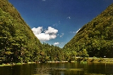
Notch Lake is an artificial lake in Edgewood, New York, in the Town of Hunter
in the Catskill Mountains
. It is located near the Stony Clove Notch
, and is located near the edge of the Devil's Tombstone Campsite, bordering New York State Route 214
. There is also a parking lot near the shore. It is the beginning of the Stony Clove Creek
.
One thing unusual about it is that it is one of the few places in the Catskills where there is a patch of Boreal Forest growing below 3,000 feet above sea level. A fire occurred near the northern shore in the 1990s.
Camping is not allowed at the day-use area next to the parking lot and Pond, however, camping is allowed a short walk South along Route 214 at the Devil's Tombstone Campground.
Hunter (town), New York
Hunter is a town in Greene County, New York. The population was 2,732 at the 2010 census.The Town of Hunter contain two villages one named Hunter and the other called Tannersville. The town is on the County's south border.- History :...
in the Catskill Mountains
Catskill Mountains
The Catskill Mountains, an area in New York State northwest of New York City and southwest of Albany, are a mature dissected plateau, an uplifted region that was subsequently eroded into sharp relief. They are an eastward continuation, and the highest representation, of the Allegheny Plateau...
. It is located near the Stony Clove Notch
Stony Clove Notch
Stony Clove Notch is a narrow pass, roughly 2,220 feet in elevation located in the Town of Hunter in Greene County, New York, deep in the Catskill Mountains. It is traversed by New York State Route 214, although in the past the Ulster and Delaware Railroad went through it as well.The notch divides...
, and is located near the edge of the Devil's Tombstone Campsite, bordering New York State Route 214
New York State Route 214
New York State Route 214 is a short but scenic state highway in the heart of the Catskill Park. It runs north–south from near the hamlet of Phoenicia up near an old railroad route into the narrow pass known as Stony Clove Notch, then down into the upper Schoharie Creek valley to end...
. There is also a parking lot near the shore. It is the beginning of the Stony Clove Creek
Stony Clove Creek
Stony Clove Creek is a creek in the Catskill Mountains in New York. It is a tributary of Esopus Creek, which in turn is a tributary of the Hudson River. It joins the Esopus in the village of Phoenicia, and has two smaller tributaries up north of Phoenicia....
.
One thing unusual about it is that it is one of the few places in the Catskills where there is a patch of Boreal Forest growing below 3,000 feet above sea level. A fire occurred near the northern shore in the 1990s.
Camping is not allowed at the day-use area next to the parking lot and Pond, however, camping is allowed a short walk South along Route 214 at the Devil's Tombstone Campground.