
.gif)
State Route 9 (Utah)
Encyclopedia
State Route 9 is a state highway in southern Utah
, serving Zion National Park
. It starts at the western terminus at exit 16 on I-15. It passes through Zion National Park, ending at the eastern junction with US-89. The entire length of the highway has been designated the Zion Park Scenic Byway
. There is a fee to travel through Zion National Park, but the highway is open to private vehicles year-round. A separate fee is required for vehicles 7'10" wide and/or 11'4" tall or larger. This fee pays for a ranger to stop traffic from the other side of the Zion - Mt. Carmel Tunnel to allow the larger vehicles to pass through.
There is a smaller tunnel in Zion National Park that does not require an escort. Commercial vehicles are prohibited from using SR-9 and are directed to use SR-20
instead.
 SR-9 begins at I-15, Exit 16, at Harrisburg Junction, just north of St. George. Immediately upon exiting I-15, SR-9 enters the Coral Canyon Development, which features an 18-hole golf course. Coral Canyon is split by the city boundaries of Hurricane
and Washington
Cities. Upon leaving this development, SR-9 passes through two ridges and begins its descent into the aptly named Purgatory Flats, home of the County Fairgrounds and a penitentiary. The 'flats' are a relatively level area between two sharply defined ridges. Quail Lake, which is in fact a reservoir, lies about a mile to the north of the road between these two ridges. Upon passing through the second ridge, SR-9 crosses the Virgin River & climbs a small plateau to the region of Hurricane
known as Brentwood. The road descends from this plateau into downtown Hurricane
, where SR-59
splits to the south and the Arizona Border. SR-9 then swings north towards the town of La Verkin
, crossing an old bridge over the La Verkin River Ravine, before entering that town. In La Verkin
, SR-17
takes off to the north, where it meets back up with I-15. After leaving La Verkin, SR-9 heads uphill and passes several mesa
s before eventually going through the small towns of Virgin, Rockville and Springdale.
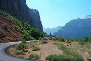
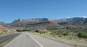
 This scenic section of SR-9 twists and turns along 14 miles (22.5 km) through Zion National Park
to Mount Carmel Junction
. This section of the road is called the Zion-Mount Carmel Highway. The highway begins on the south side of Zion National Park
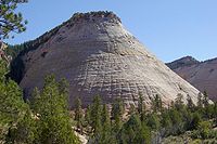
following along the Virgin River. The road then turns at the junction of Pine Creek and the Virgin River and continues up Pine Creek Canyon, up the Switchbacks and into the Zion-Mt. Carmel Tunnel. On the east side of the tunnel the highway continues through impressive scenery, past the Canyon Overlook Trailhead, the East Rim Trailhead and the unique Zion landmark, Checkerboard Mesa. Finally the road exits the park through the east entrance and 12 miles (19.3 km) later ends at the junction of SR-9 and US-89 in Mount Carmel Junction.
 The road from Hurricane north through La Verkin to US-91 at Anderson Junction was added to the state highway system in 1912, and a branch was added from La Verkin Junction east to Zion National Park
in 1916 and beyond to Mt. Carmel Junction in 1923. In the 1920s, the State Road Commission assigned State Route 15 to the road from Anderson Junction to the park, while State Route 16 included the branch to Hurricane (and continued southeast to Arizona
via present SR-59). In 1927, the state legislature extended SR-15 through the park to Mt. Carmel Junction, and added a new State Route 17, which formed a cutoff from US-91 at Harrisburg Junction east to Hurricane. SR-17 also included SR-16 from Hurricane north to La Verkin Junction and southeast to Big Plain Junction, where the realigned SR-16 turned north to SR-15 at Rockville. The portion of SR-17 from Hurricane to Big Plain Junction was split off as SR-59 in 1931, leaving SR-15 and SR-17 as a loop off US-91 through Hurricane and La Verkin, with SR-15 continuing east through Zion National Park.
Construction began through and east of the national park in 1927, on the portion that had been added to the state highway system in 1923 and to SR-15 in 1927. The Nevada Construction Company completed the Zion-Mt. Carmel Tunnel in 1930, after three years of construction and a cost of $1,896,000. SR-15 and SR-17 were swapped in 1969, giving SR-15 the route from Harrisburg Junction and SR-17 its present route. In the 1977 renumbering, SR-15 was renumbered SR-9 due to the existence of Interstate 15.
Utah
Utah is a state in the Western United States. It was the 45th state to join the Union, on January 4, 1896. Approximately 80% of Utah's 2,763,885 people live along the Wasatch Front, centering on Salt Lake City. This leaves vast expanses of the state nearly uninhabited, making the population the...
, serving Zion National Park
Zion National Park
Zion National Park is located in the Southwestern United States, near Springdale, Utah. A prominent feature of the park is Zion Canyon, which is 15 miles long and up to half a mile deep, cut through the reddish and tan-colored Navajo Sandstone by the North Fork of the Virgin River...
. It starts at the western terminus at exit 16 on I-15. It passes through Zion National Park, ending at the eastern junction with US-89. The entire length of the highway has been designated the Zion Park Scenic Byway
Utah Scenic Byways
The legislature in the U.S. state of Utah has designated a system of Utah Scenic Byways in addition to the National Scenic Byways that are defined within the state. Some of the state designated routes overlap with the federal designations...
. There is a fee to travel through Zion National Park, but the highway is open to private vehicles year-round. A separate fee is required for vehicles 7'10" wide and/or 11'4" tall or larger. This fee pays for a ranger to stop traffic from the other side of the Zion - Mt. Carmel Tunnel to allow the larger vehicles to pass through.
There is a smaller tunnel in Zion National Park that does not require an escort. Commercial vehicles are prohibited from using SR-9 and are directed to use SR-20
Utah State Route 20
State Route 20 is a state highway in southern Utah, running in Iron and Garfield Counties, without directly serving or connecting any cities. It serves as a truck connection between I-15 and US-89 and an access to Bryce Canyon National Park. It may also be used to travel between Salt Lake City...
instead.
St. George to Zion National Park
Hurricane, Utah
Hurricane is a city in Washington County, Utah. Its population was 13,748 at the 2010 U.S. Census. Along with several other areas of southwestern Utah, the Hurricane area has seen a large population growth since the 1970s, and it has blended in with neighboring city of St...
and Washington
Washington, Utah
Washington is a city in Washington County, Utah, United States. The population was 8,186 at the 2000 census, and 18,761 as of the 2010 Census. Washington is east of St...
Cities. Upon leaving this development, SR-9 passes through two ridges and begins its descent into the aptly named Purgatory Flats, home of the County Fairgrounds and a penitentiary. The 'flats' are a relatively level area between two sharply defined ridges. Quail Lake, which is in fact a reservoir, lies about a mile to the north of the road between these two ridges. Upon passing through the second ridge, SR-9 crosses the Virgin River & climbs a small plateau to the region of Hurricane
Hurricane, Utah
Hurricane is a city in Washington County, Utah. Its population was 13,748 at the 2010 U.S. Census. Along with several other areas of southwestern Utah, the Hurricane area has seen a large population growth since the 1970s, and it has blended in with neighboring city of St...
known as Brentwood. The road descends from this plateau into downtown Hurricane
Hurricane, Utah
Hurricane is a city in Washington County, Utah. Its population was 13,748 at the 2010 U.S. Census. Along with several other areas of southwestern Utah, the Hurricane area has seen a large population growth since the 1970s, and it has blended in with neighboring city of St...
, where SR-59
Utah State Route 59
State Route 59 is a state highway in the U.S. state of Utah. The highway connects Hurricane to the twin cities of Hildale and Colorado City, Arizona. The highway connects to US-89A through Arizona State Route 389...
splits to the south and the Arizona Border. SR-9 then swings north towards the town of La Verkin
La Verkin, Utah
La Verkin is a city in Washington County, Utah, United States. The population was 4,719 as of 2010, an increase from 3,392 in 2000. La Verkin is within walking distance of Hurricane, Utah, and the two cities have historically had close ties....
, crossing an old bridge over the La Verkin River Ravine, before entering that town. In La Verkin
La Verkin, Utah
La Verkin is a city in Washington County, Utah, United States. The population was 4,719 as of 2010, an increase from 3,392 in 2000. La Verkin is within walking distance of Hurricane, Utah, and the two cities have historically had close ties....
, SR-17
Utah State Route 17
State Route 17 is a state highway in southern Utah, running for in Washington County from La Verkin to Anderson Junction near Toquerville. It serves as a shortcut from I-15 to Zion National Park.-Route description:...
takes off to the north, where it meets back up with I-15. After leaving La Verkin, SR-9 heads uphill and passes several mesa
Mesa
A mesa or table mountain is an elevated area of land with a flat top and sides that are usually steep cliffs. It takes its name from its characteristic table-top shape....
s before eventually going through the small towns of Virgin, Rockville and Springdale.
Zion National Park to Mount Carmel Junction, Utah
Zion National Park
Zion National Park is located in the Southwestern United States, near Springdale, Utah. A prominent feature of the park is Zion Canyon, which is 15 miles long and up to half a mile deep, cut through the reddish and tan-colored Navajo Sandstone by the North Fork of the Virgin River...
to Mount Carmel Junction
Mount Carmel Junction, Utah
Mount Carmel Junction and Mount Carmel are unincorporated areas located east of Zion National Park and north of Kanab in Kane County, Utah, United States. They lie in close proximity to the beautiful Coral Pink Sand Dunes state park....
. This section of the road is called the Zion-Mount Carmel Highway. The highway begins on the south side of Zion National Park
Zion National Park
Zion National Park is located in the Southwestern United States, near Springdale, Utah. A prominent feature of the park is Zion Canyon, which is 15 miles long and up to half a mile deep, cut through the reddish and tan-colored Navajo Sandstone by the North Fork of the Virgin River...
following along the Virgin River. The road then turns at the junction of Pine Creek and the Virgin River and continues up Pine Creek Canyon, up the Switchbacks and into the Zion-Mt. Carmel Tunnel. On the east side of the tunnel the highway continues through impressive scenery, past the Canyon Overlook Trailhead, the East Rim Trailhead and the unique Zion landmark, Checkerboard Mesa. Finally the road exits the park through the east entrance and 12 miles (19.3 km) later ends at the junction of SR-9 and US-89 in Mount Carmel Junction.
History
Zion National Park
Zion National Park is located in the Southwestern United States, near Springdale, Utah. A prominent feature of the park is Zion Canyon, which is 15 miles long and up to half a mile deep, cut through the reddish and tan-colored Navajo Sandstone by the North Fork of the Virgin River...
in 1916 and beyond to Mt. Carmel Junction in 1923. In the 1920s, the State Road Commission assigned State Route 15 to the road from Anderson Junction to the park, while State Route 16 included the branch to Hurricane (and continued southeast to Arizona
Arizona
Arizona ; is a state located in the southwestern region of the United States. It is also part of the western United States and the mountain west. The capital and largest city is Phoenix...
via present SR-59). In 1927, the state legislature extended SR-15 through the park to Mt. Carmel Junction, and added a new State Route 17, which formed a cutoff from US-91 at Harrisburg Junction east to Hurricane. SR-17 also included SR-16 from Hurricane north to La Verkin Junction and southeast to Big Plain Junction, where the realigned SR-16 turned north to SR-15 at Rockville. The portion of SR-17 from Hurricane to Big Plain Junction was split off as SR-59 in 1931, leaving SR-15 and SR-17 as a loop off US-91 through Hurricane and La Verkin, with SR-15 continuing east through Zion National Park.
Construction began through and east of the national park in 1927, on the portion that had been added to the state highway system in 1923 and to SR-15 in 1927. The Nevada Construction Company completed the Zion-Mt. Carmel Tunnel in 1930, after three years of construction and a cost of $1,896,000. SR-15 and SR-17 were swapped in 1969, giving SR-15 the route from Harrisburg Junction and SR-17 its present route. In the 1977 renumbering, SR-15 was renumbered SR-9 due to the existence of Interstate 15.
Major intersections
| County | Location | Mile | Destinations | Notes |
|---|---|---|---|---|
| Washington | Washington, Hurricane |
0.000 | – Las Vegas, Cedar City, Salt Lake | Interchange |
| 0.512 | Coral Canyon Boulevard | Interchange | ||
| 1.107 | Telegraph Street | Former SR-212; older US-91 | ||
| Hurricane | ||||
| 2.766 | – Quail Creek State Park Quail Creek State Park Quail Creek State Park is a state park of Utah, USA, featuring a reservoir. The park is located west of Hurricane and south of Harrisburg. Quail Creek State Park offers camping, boating, swimming, and fishing.... |
|||
| 9.776 | – Grand Canyon Grand Canyon The Grand Canyon is a steep-sided canyon carved by the Colorado River in the United States in the state of Arizona. It is largely contained within the Grand Canyon National Park, the 15th national park in the United States... |
|||
| La Verkin | 12.458 | |||
| Rockville | 28.102 | Bridge Road (Rockville Bridge) | Former SR-16 | |
| Zion National Park Zion National Park Zion National Park is located in the Southwestern United States, near Springdale, Utah. A prominent feature of the park is Zion Canyon, which is 15 miles long and up to half a mile deep, cut through the reddish and tan-colored Navajo Sandstone by the North Fork of the Virgin River... |
Floor of the Valley Road Floor of the Valley Road The Floor of the Valley Road, also known as the Zion Canyon Scenic Drive, follows the canyon of the North Fork of the Virgin River, also known as Zion Canyon, through Zion National Park, Utah... |
|||
| Kane | Mt. Carmel Junction | 57.075 |