

Mount Carmel Junction, Utah
Encyclopedia
Mount Carmel Junction and Mount Carmel are unincorporated area
s located 12 miles (19.3 km) east of Zion National Park
and 17 miles (27.4 km) north of Kanab
in Kane County
, Utah
, United States
. They lie in close proximity to the beautiful Coral Pink Sand Dunes state park
.
The resort community of Mount Carmel Junction sits at the junction of U.S. Route 89 and State Route 9
in southwestern Utah. Mount Carmel is one mile (1.6 km) north of the junction. Mount Carmel is set in the high desert of the Colorado Plateau.
were the prehistoric settlers in the area. Among other areas, nearby Parunuweap (East Fork of the Virgin River) contains evidence to their presence. This group occupied the area until about the 13th century. The people were agriculturalists who maintained a diet of mostly maize.
's plan to settle all of Utah Territory. In 1865 more settlers were sent by the church. Nearby Orderville
and Glendale
(called Berryville at this time) were also being settled. Before long, Indians forced them to leave the area. It was not until 7 years later in 1871 that the settlers returned and this time settled down permanently. This time the town was settled in the name of Mount Carmel to honor the mountain in Palestine. In 1875 Elder Howard O. Spencer presided over Mount Carmel and Glendale. He reported that most homes were temporary, but permanent structures were underway. Doctor Meeks moved to Orderville in 1876 where he died at the age of 91. He left behind two wives and several children.
Few, perhaps less than three families ever settled in Mt. Carmel Jct., but one of the few was Jack Morrison. He contemplated the idea that a road must be built connecting Zion Canyon to the east side of the park. Jack explored the area and came to the conclusion that the road must come down in the area now known as Mount Carmel Junction. There were old wagon trails that Jack used to navigate his way down to the valley. The hills were steep forcing Jack to attach a Cedar tree to the back of his Model-T-Ford. Jack came home excited and declared to his wife Fern that: "I think I know where the road from Zion is going to come down. I'd like to use my Veteran and homestead rights to file on that land."
A cattle rancher had filed grazing rights on the land, but Jack was patient and in 1931 he was able to homestead the land now known as Mount Carmel Junction. The land was unkind. It was covered with gullies, quicksand and many layers of sand. The area was also prone to violent flash floods. The task was difficult but Jack set to work building strategic dams to aid in landscaping the area. To support their endeavor and his family Jack had to work on the railroad, leaving his wife and four children often. Fern Morrison enjoyed baking and constructed a lean-to so she could sell pies to passers-by. In 1940, Jack and Fern built a restaurant. This was still a remote and wild area and it was hard to survive before the Zion-Mount Carmel Highway was completed. Jack and Fern lost two children in the flash floods of the East Fork of the Virgin River that runs through the junction. The East Fork is now known as Parunuweap or the Barracks and is popular hike that is similar to the Zion Narrows but in a remote and pristine area just outside of the park boundary. Jack died in 1961, from cancer after spending much of his life working in the coal mines. Fern, a strong willed and hard working woman continued to build. She lived to the age of 90, dying in 1998. What stands at the junction today was done in her lifetime and was rare for a woman to do at those times. Fern kept the original little home she gave birth to her children in and built around it. There are also two original Zion Canyon cabins that are a part of that home.
Artist Maynard Dixon
,http://www.thunderbirdfoundation.com/maynard-dixon.cfm famed for his paintings of the American West, built a summer home
in Mount Carmel Junction in 1939. After his death in Tucson, Arizona, in 1946, his ashes were buried on a high bluff above the Mount Carmel art studio being built on the property.
 John Wesley Powell
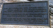
visited the area as part of the Powell Survey of 1872. He was the first European-American to descend the East Fork of the Virgin River from the current location of Mount Carmel Junction to Shunesburg. A plaque can be found just east of the Zion National Park boundary in the East Fork, that reads:
"Major John Wesley Powell 1834-1902 explorer, scientist, Steven V. Jones 1840-1920 teacher, topographer, Joseph W. Young 1829-1873 Mormon pioneer leader, Descended Labyrinth Falls 1/2 mile below Monday, September 30, 1872 during first Parunuweap Canyon traverse. Powell named this canyon from the Paiute Indian word 'Parunuweap' which means roaring water canyon. Dedicated September 30, 1972."
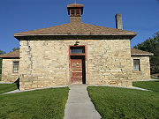 The Historic Rock Church in Mount Carmel was used to school the children living in the Mount Carmel
area. The log building was built in 1880 and used as a church, school house and recreation hall. In 1890 it was converted into the stone structure.
"The rock for the building was hauled by team and wagon from a hill about a mile south of town. Later a lumber wing was added, making it into a two-room school. At first the floors were of rough pine lumber. Then hardwood floors were installed, which made them 'nicer for dancing.'"
In 1919 it burned down. In 1923 it was rebuilt, this time with rock. After the small building was rebuilt, the rock structure was used almost entirely as a church. The children who once attended school in the log building rode to nearby Orderville in a covered wagon each day to attend school. The Historic Rock Church is on the National Register of Historic Places.
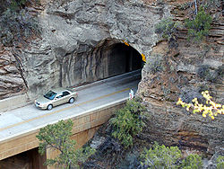 In 1919, a Congressional bill designating Zion National Park
was signed into law. In 1923 the task of finding a way to open Zion Canyon to the east side of the park began. Four different routes were considered including two options through Parunuweap and another through North Creek. The route chosen went up the side of Pine Creek canyon on switchbacks, through a tunnel and then along Clear Creek to the east boundary of the park, and hence to Highway 89 at Mt. Carmel Junction. Construction work on the Zion-Mount Carmel Tunnel and the Zion-Mount Carmel Highway
began in 1927. The tunnel especially was considered quite an engineering feat for the time, requiring boring 5613 feet (1,710.8 m) through solid rock. July 4, 1930, the tunnel and highway were dedicated, linking Zion Canyon
to the land east of the park and making it easier to visit Grand Canyon
and Bryce Canyon
National Parks.
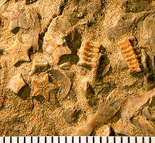 The north-south trending Sevier Fault is 2 miles (3.2 km) east of the main highway through Mount Carmel Junction. Sandstone cliffs lie to the south and the White Cliffs of the Grand Staircase
can be seen to the east. About halfway between Mount Carmel Junction and Kanab are the Coral Pink Sand Dunes. North on U.S. Route 89 are hoodoo formations similar to those in Bryce Canyon and Cedar Breaks. The Middle Jurassic Carmel Formation, named after Mount Carmel, is well exposed in this area. Crinoid
fossils are abundant in this unit, forming an encrinite in places. Crinoids have pentameral symmetry and here the stalks have broken down into tiny, individual star-shaped fossils (columnals). The crinoid is Isocrinus nicoleti, the first cosmopolitan crinoid reported from North American Jurassic strata (Tang et al., 2007).
Unincorporated area
In law, an unincorporated area is a region of land that is not a part of any municipality.To "incorporate" in this context means to form a municipal corporation, a city, town, or village with its own government. An unincorporated community is usually not subject to or taxed by a municipal government...
s located 12 miles (19.3 km) east of Zion National Park
Zion National Park
Zion National Park is located in the Southwestern United States, near Springdale, Utah. A prominent feature of the park is Zion Canyon, which is 15 miles long and up to half a mile deep, cut through the reddish and tan-colored Navajo Sandstone by the North Fork of the Virgin River...
and 17 miles (27.4 km) north of Kanab
Kanab, Utah
Kanab is a city in and the county seat of Kane County, Utah, United States. The area was first settled in 1864 and the town was founded in 1870 when ten Mormon families moved into the area. The population was 3,564 at the 2000 census...
in Kane County
Kane County, Utah
As of the census of 2000, there were 6,046 people, 2,237 households, and 1,628 families residing in the county. The population density was 2 people per square mile . There were 3,767 housing units at an average density of 1 per square mile...
, Utah
Utah
Utah is a state in the Western United States. It was the 45th state to join the Union, on January 4, 1896. Approximately 80% of Utah's 2,763,885 people live along the Wasatch Front, centering on Salt Lake City. This leaves vast expanses of the state nearly uninhabited, making the population the...
, United States
United States
The United States of America is a federal constitutional republic comprising fifty states and a federal district...
. They lie in close proximity to the beautiful Coral Pink Sand Dunes state park
Coral Pink Sand Dunes State Park
Coral Pink Sand Dunes State Park is a state park of Utah, USA, located between Mount Carmel Junction and Kanab, south and west of U.S. Highway 89 in southwestern Utah...
.
The resort community of Mount Carmel Junction sits at the junction of U.S. Route 89 and State Route 9
State Route 9 (Utah)
State Route 9 is a state highway in southern Utah, serving Zion National Park. It starts at the western terminus at exit 16 on I-15. It passes through Zion National Park, ending at the eastern junction with US-89. The entire length of the highway has been designated the Zion Park Scenic Byway...
in southwestern Utah. Mount Carmel is one mile (1.6 km) north of the junction. Mount Carmel is set in the high desert of the Colorado Plateau.
History
The Virgin AnasaziVirgin Anasazi
The Virgin Anasazi were the westernmost Ancestral Puebloan group in the American Southwest. They occupied the area in and around the Virgin River and Muddy Rivers, the western Colorado Plateau, the Moapa Valley and were bordered to the south by the Colorado River. They occupied areas in present day...
were the prehistoric settlers in the area. Among other areas, nearby Parunuweap (East Fork of the Virgin River) contains evidence to their presence. This group occupied the area until about the 13th century. The people were agriculturalists who maintained a diet of mostly maize.
Settlement
Doctor Priddy Meeks settled the town of Winsor in 1864, at the site of present day Mount Carmel Junction, as part of Brigham YoungBrigham Young
Brigham Young was an American leader in the Latter Day Saint movement and a settler of the Western United States. He was the President of The Church of Jesus Christ of Latter-day Saints from 1847 until his death in 1877, he founded Salt Lake City, and he served as the first governor of the Utah...
's plan to settle all of Utah Territory. In 1865 more settlers were sent by the church. Nearby Orderville
Orderville, Utah
Orderville is a town in Kane County, Utah, United States. The population was 596 at the 2000 census.-Geography:Orderville is located at ....
and Glendale
Glendale, Utah
Glendale is a town in Kane County, Utah, United States. The population was 355 at the 2000 census. It was founded in 1862 by Mormon pioneers John and William Berry, abandoned in 1866 due to Indian attacks, and resettled in 1871.-Geography:...
(called Berryville at this time) were also being settled. Before long, Indians forced them to leave the area. It was not until 7 years later in 1871 that the settlers returned and this time settled down permanently. This time the town was settled in the name of Mount Carmel to honor the mountain in Palestine. In 1875 Elder Howard O. Spencer presided over Mount Carmel and Glendale. He reported that most homes were temporary, but permanent structures were underway. Doctor Meeks moved to Orderville in 1876 where he died at the age of 91. He left behind two wives and several children.
Few, perhaps less than three families ever settled in Mt. Carmel Jct., but one of the few was Jack Morrison. He contemplated the idea that a road must be built connecting Zion Canyon to the east side of the park. Jack explored the area and came to the conclusion that the road must come down in the area now known as Mount Carmel Junction. There were old wagon trails that Jack used to navigate his way down to the valley. The hills were steep forcing Jack to attach a Cedar tree to the back of his Model-T-Ford. Jack came home excited and declared to his wife Fern that: "I think I know where the road from Zion is going to come down. I'd like to use my Veteran and homestead rights to file on that land."
A cattle rancher had filed grazing rights on the land, but Jack was patient and in 1931 he was able to homestead the land now known as Mount Carmel Junction. The land was unkind. It was covered with gullies, quicksand and many layers of sand. The area was also prone to violent flash floods. The task was difficult but Jack set to work building strategic dams to aid in landscaping the area. To support their endeavor and his family Jack had to work on the railroad, leaving his wife and four children often. Fern Morrison enjoyed baking and constructed a lean-to so she could sell pies to passers-by. In 1940, Jack and Fern built a restaurant. This was still a remote and wild area and it was hard to survive before the Zion-Mount Carmel Highway was completed. Jack and Fern lost two children in the flash floods of the East Fork of the Virgin River that runs through the junction. The East Fork is now known as Parunuweap or the Barracks and is popular hike that is similar to the Zion Narrows but in a remote and pristine area just outside of the park boundary. Jack died in 1961, from cancer after spending much of his life working in the coal mines. Fern, a strong willed and hard working woman continued to build. She lived to the age of 90, dying in 1998. What stands at the junction today was done in her lifetime and was rare for a woman to do at those times. Fern kept the original little home she gave birth to her children in and built around it. There are also two original Zion Canyon cabins that are a part of that home.
Artist Maynard Dixon
Maynard Dixon
Maynard Dixon was a 20th-century American artist whose body of work focused on the American West. He was married for a time to American photographer Dorothea Lange.-Biography:...
,http://www.thunderbirdfoundation.com/maynard-dixon.cfm famed for his paintings of the American West, built a summer home
Maynard and Edith Hamlin Dixon House and Studio
The Maynard and Edith Hamlin Dixon House and Studio is a residence and former painting studio in Mount Carmel, Utah. Maynard Dixon was a prominent artist in the 1920s through 1940s who is best known for his landscape paintings of the American West. He moved to Mount Carmel in 1939 shortly after...
in Mount Carmel Junction in 1939. After his death in Tucson, Arizona, in 1946, his ashes were buried on a high bluff above the Mount Carmel art studio being built on the property.
John Wesley Powell - Parunuweap
John Wesley Powell
John Wesley Powell was a U.S. soldier, geologist, explorer of the American West, and director of major scientific and cultural institutions...
visited the area as part of the Powell Survey of 1872. He was the first European-American to descend the East Fork of the Virgin River from the current location of Mount Carmel Junction to Shunesburg. A plaque can be found just east of the Zion National Park boundary in the East Fork, that reads:
"Major John Wesley Powell 1834-1902 explorer, scientist, Steven V. Jones 1840-1920 teacher, topographer, Joseph W. Young 1829-1873 Mormon pioneer leader, Descended Labyrinth Falls 1/2 mile below Monday, September 30, 1872 during first Parunuweap Canyon traverse. Powell named this canyon from the Paiute Indian word 'Parunuweap' which means roaring water canyon. Dedicated September 30, 1972."
Historic Rock Church
area. The log building was built in 1880 and used as a church, school house and recreation hall. In 1890 it was converted into the stone structure.
"The rock for the building was hauled by team and wagon from a hill about a mile south of town. Later a lumber wing was added, making it into a two-room school. At first the floors were of rough pine lumber. Then hardwood floors were installed, which made them 'nicer for dancing.'"
In 1919 it burned down. In 1923 it was rebuilt, this time with rock. After the small building was rebuilt, the rock structure was used almost entirely as a church. The children who once attended school in the log building rode to nearby Orderville in a covered wagon each day to attend school. The Historic Rock Church is on the National Register of Historic Places.
Zion-Mount Carmel Highway History
Zion National Park
Zion National Park is located in the Southwestern United States, near Springdale, Utah. A prominent feature of the park is Zion Canyon, which is 15 miles long and up to half a mile deep, cut through the reddish and tan-colored Navajo Sandstone by the North Fork of the Virgin River...
was signed into law. In 1923 the task of finding a way to open Zion Canyon to the east side of the park began. Four different routes were considered including two options through Parunuweap and another through North Creek. The route chosen went up the side of Pine Creek canyon on switchbacks, through a tunnel and then along Clear Creek to the east boundary of the park, and hence to Highway 89 at Mt. Carmel Junction. Construction work on the Zion-Mount Carmel Tunnel and the Zion-Mount Carmel Highway
State Route 9 (Utah)
State Route 9 is a state highway in southern Utah, serving Zion National Park. It starts at the western terminus at exit 16 on I-15. It passes through Zion National Park, ending at the eastern junction with US-89. The entire length of the highway has been designated the Zion Park Scenic Byway...
began in 1927. The tunnel especially was considered quite an engineering feat for the time, requiring boring 5613 feet (1,710.8 m) through solid rock. July 4, 1930, the tunnel and highway were dedicated, linking Zion Canyon
Zion Canyon
Zion Canyon is a deep and narrow gorge in southwestern Utah, United States, carved by the North Fork of the Virgin River...
to the land east of the park and making it easier to visit Grand Canyon
Grand Canyon National Park
Grand Canyon National Park is the United States' 15th oldest national park and is located in Arizona. Within the park lies the Grand Canyon, a gorge of the Colorado River, considered to be one of the Wonders of the World. The park covers of unincorporated area in Coconino and Mohave counties.Most...
and Bryce Canyon
Bryce Canyon National Park
Bryce Canyon National Park is a national park located in southwestern Utah in the United States. The major feature of the park is Bryce Canyon which, despite its name, is not a canyon but a giant natural amphitheater created by erosion along the eastern side of the Paunsaugunt Plateau...
National Parks.
Geology
Grand Staircase
For the similarly named structure on the RMS Titanic, see Grand Staircase of the TitanicFor the stairs in the White House see Grand Staircase ...
can be seen to the east. About halfway between Mount Carmel Junction and Kanab are the Coral Pink Sand Dunes. North on U.S. Route 89 are hoodoo formations similar to those in Bryce Canyon and Cedar Breaks. The Middle Jurassic Carmel Formation, named after Mount Carmel, is well exposed in this area. Crinoid
Crinoid
Crinoids are marine animals that make up the class Crinoidea of the echinoderms . Crinoidea comes from the Greek word krinon, "a lily", and eidos, "form". They live both in shallow water and in depths as great as 6,000 meters. Sea lilies refer to the crinoids which, in their adult form, are...
fossils are abundant in this unit, forming an encrinite in places. Crinoids have pentameral symmetry and here the stalks have broken down into tiny, individual star-shaped fossils (columnals). The crinoid is Isocrinus nicoleti, the first cosmopolitan crinoid reported from North American Jurassic strata (Tang et al., 2007).