
.gif)
State Route 89A (Arizona)
Encyclopedia
State Route 89A is a 83.85 miles (134.9 km) state highway
that runs from Prescott
north to Flagstaff
in the U.S. state
of Arizona
. The highway begins at SR 89 and heads northward from Prescott, entering Jerome
. From Jerome, the route then heads to Cottonwood
and Sedona
. The highway is notable for its scenic value as it passes through Sedona and the Oak Creek Canyon
. The route then enters Flagstaff
, where it crosses Interstate 17
(I-17) and I-40
. The highway ends at I-40 Business in Flagstaff. What is now SR 89A became a state highway in the late 1920s as SR 79. The highway was extended and improved several times through 1938. SR 79 was renumbered to U.S. Route 89A (US 89A) in 1941 and then to SR 89A in the early 1990s.
northward through the towns of Jerome
, Cottonwood
and Sedona
to its northern terminus in Flagstaff
. The highway is known for its scenic views as it passes through the Sedona and Oak Creek Canyon
.
. The road heads east from the junction with SR 89 as a four-lane divided highway
with diamond interchange
s located at most intersections. It continues as a divided highway until it reaches Fain Road in Prescott Valley
. The route continues beyond this intersection as a two-lane undivided highway through desert.
 As SR 89A moves to the northeast, it begins to ascend the Black Hills mountain range. The roadway follows the terrain through a series of hairpin turn
s as the it climbs in elevation. Once SR 89A reaches passes over the mountains, it begins its descent into the Verde Valley
. During its descent, SR 89A enters the town of Jerome
. In Jerome, the highway provides access to the nearby Jerome State Historical Park.
, it turns southeast at an intersection with Clarkdale Parkway. The route continues towards the southeast through Clarkdale before entering the town of Cottonwood
. In Cottonwood, the highway follows the old alignment of Cottonwood Street before reaching an intersection with Main Street.
The historic route of 89A from Clarkdale to Cottonwood, when part of US 89A, ran through the old downtown areas of each city. From Jerome, the route continued along 11th Street (now Clarkdale Parkway), turning right at Main Street in Clarkdale, and then right again at Broadway. It continued past Tuzigoot National Monument
, becoming Main Street in Cottonwood, and providing access to Dead Horse Ranch State Park
. The route intersects Cottonwood Street, where the bypass route now intersects Main Street. This portion is now signed as "Historic U.S. 89A."
 Following the intersection with Cottonwood Street, the road follows Main Street to an intersection with SR 260, which heads to the south toward Camp Verde
and I-17
. SR 89A then moves northeastward towards Sedona
.
As the highway leaves Cottonwood
, it again becomes a divided highway north of Rocking Chair Road, heading into desert. Before reaching Sedona, SR 89A provides access to Red Rock State Park
. The route remains a divided highway until it reaches Sedona, an arts and resort community known for its red sandstone
formations. As it enters the city of Sedona, the route is known as the Si Birch Memorial Highway. The route continues east through Sedona, providing access to the Sedona Airport
. SR 89A continues towards the east through Sedona to an intersection with SR 179, which heads south from this intersection through the southern part of Sedona to provide access to I-17
.
along this portion of the highway. The roadway leaves the creek as it begins to ascend through the canyon. Upon ascending, the road goes through a series of hairpin turn
s towards the Mogollon Rim
. The roadway continues northward away from the canyon towards Flagstaff
. It curves northeastward as it passes to the west of the Forest Highlands Gold Club. The route continues to the northeast to I-17 in Flagstaff near Flagstaff Pulliam Airport
. SR 89A begins to run concurrently
with I-17
as a freeway northward. The two highways continue north to an interchange with I-40
, where I-17 terminates. The route continues north along Milton Road, passing to the west of Northern Arizona University
before reaching its northern terminus at Interstate 40 Business in Flagstaff.
 The routing of SR 89A was first defined as a state highway in 1927 as SR 79 by the Arizona Department of Transportation
(ADOT). At the time, only the portion from Prescott to Clarkdale was built, but the remaining portion to Flagstaff had been planned. By 1929, the highway had been extended north to Sedona, although the entire highway was not paved at this time. A graded dirt road was built the following year between Flagstaff and Sedona. The southern half of the section between Sedona and Flagstaff had been improved to a gravel road by 1934, with the northern half under construction. The next year, the construction on the northern section near Flagstaff was complete. The southern end of the highway near Prescott and the section between Jerome and Cottonwood had been paved by this time. By 1938, the entire route had been paved.
By 1941, the highway was redesignated from SR 79 to US 89A. Before the establishment of the route for I-17
, the only route to Flagstaff was through Prescott. There were two routes available: US 89A through Jerome, Cottonwood, Clarkdale, Sedona and Oak Creek Canyon or north through Chino Valley via US 89 to US 66. Upon the completion of I-17 by 1971, the section concurrent with that freeway was upgraded to Interstate standards. The route was redesignated from US 89A to SR 89A in 1993.
!County
!Location
!Mile
!Exit
!Junction
!Notes
|-
|rowspan=8|Yavapai
|rowspan=3|Prescott
|0.00
|317
|
|
|-
|0.96
|318
|Larry Caldwell Drive
|
|-
|1.42
|319
|Granite Dells Parkway
|
|-
|rowspan=4|Prescott Valley
|4.21
|322
|Glassford Hill Road
|
|-
|4.96
|323
|Viewpoint Drive
|
|-
|5.62
|
|Fain Road
|Y interchange, Fain Road continues 8 miles to meet
|-
|
|colspan=3 align="center"|End freeway
|-
|Cottonwood
|36.23
|
|
|
|-
|rowspan=4|Coconino
|Sedona
|54.80
|
|
|
|-
|rowspan=3|Flagstaff
|79.66
|
|
|South end of I-17 overlap
|-
|82.62
|
| – Los Angeles
, Albuquerque
|North end of I-17 overlap
|-
|83.85
|
| – Los Angeles
, Page
, Grand Canyon
|Old US 66
State highway
State highway, state road or state route can refer to one of three related concepts, two of them related to a state or provincial government in a country that is divided into states or provinces :#A...
that runs from Prescott
Prescott, Arizona
Prescott is a city in Yavapai County, Arizona, USA. It was designated "Arizona's Christmas City" by Arizona Governor Rose Mofford in the late 1980s....
north to Flagstaff
Flagstaff, Arizona
Flagstaff is a city located in northern Arizona, in the southwestern United States. In 2010, the city's population was 65,870. The population of the Metropolitan Statistical Area was at 134,421 in 2010. It is the county seat of Coconino County...
in the U.S. state
U.S. state
A U.S. state is any one of the 50 federated states of the United States of America that share sovereignty with the federal government. Because of this shared sovereignty, an American is a citizen both of the federal entity and of his or her state of domicile. Four states use the official title of...
of Arizona
Arizona
Arizona ; is a state located in the southwestern region of the United States. It is also part of the western United States and the mountain west. The capital and largest city is Phoenix...
. The highway begins at SR 89 and heads northward from Prescott, entering Jerome
Jerome, Arizona
Jerome is a town in Yavapai County, Arizona, United States. According to 2006 Census Bureau estimates, the population of the town is 353.-History:...
. From Jerome, the route then heads to Cottonwood
Cottonwood, Arizona
Cottonwood is a city in Yavapai County, Arizona, United States. According to 2006 Census Bureau estimates, the population of the city is 11,171.-Geography:Cottonwood is located at ....
and Sedona
Sedona, Arizona
Sedona is a city that straddles the county line between Coconino and Yavapai counties in the northern Verde Valley region of the U.S. state of Arizona...
. The highway is notable for its scenic value as it passes through Sedona and the Oak Creek Canyon
Oak Creek Canyon
Oak Creek Canyon is a river gorge located along the Mogollon Rim in northern Arizona located between the cities of Flagstaff and Sedona. The canyon is often described as a smaller cousin of the Grand Canyon because of its scenic beauty...
. The route then enters Flagstaff
Flagstaff, Arizona
Flagstaff is a city located in northern Arizona, in the southwestern United States. In 2010, the city's population was 65,870. The population of the Metropolitan Statistical Area was at 134,421 in 2010. It is the county seat of Coconino County...
, where it crosses Interstate 17
Interstate 17
Interstate 17 , also known as the Black Canyon Freeway, is an intrastate Interstate Highway located entirely within the state of Arizona, United States. I-17's southern terminus lies within Phoenix, at Interstate 10, and its northern terminus is in Flagstaff, at Interstate 40...
(I-17) and I-40
Interstate 40 in Arizona
Interstate 40 is an east–west Interstate Highway that has a section in the U.S. state of Arizona connecting sections in California to New Mexico. It enters Arizona from the west at a crossing of the Colorado River southwest of Kingman...
. The highway ends at I-40 Business in Flagstaff. What is now SR 89A became a state highway in the late 1920s as SR 79. The highway was extended and improved several times through 1938. SR 79 was renumbered to U.S. Route 89A (US 89A) in 1941 and then to SR 89A in the early 1990s.
Route description
SR 89A runs from its southern terminus in PrescottPrescott, Arizona
Prescott is a city in Yavapai County, Arizona, USA. It was designated "Arizona's Christmas City" by Arizona Governor Rose Mofford in the late 1980s....
northward through the towns of Jerome
Jerome, Arizona
Jerome is a town in Yavapai County, Arizona, United States. According to 2006 Census Bureau estimates, the population of the town is 353.-History:...
, Cottonwood
Cottonwood, Arizona
Cottonwood is a city in Yavapai County, Arizona, United States. According to 2006 Census Bureau estimates, the population of the city is 11,171.-Geography:Cottonwood is located at ....
and Sedona
Sedona, Arizona
Sedona is a city that straddles the county line between Coconino and Yavapai counties in the northern Verde Valley region of the U.S. state of Arizona...
to its northern terminus in Flagstaff
Flagstaff, Arizona
Flagstaff is a city located in northern Arizona, in the southwestern United States. In 2010, the city's population was 65,870. The population of the Metropolitan Statistical Area was at 134,421 in 2010. It is the county seat of Coconino County...
. The highway is known for its scenic views as it passes through the Sedona and Oak Creek Canyon
Oak Creek Canyon
Oak Creek Canyon is a river gorge located along the Mogollon Rim in northern Arizona located between the cities of Flagstaff and Sedona. The canyon is often described as a smaller cousin of the Grand Canyon because of its scenic beauty...
.
Prescott to Jerome
The southern terminus of SR 89A is located at a junction with SR 89 north of Prescott near the Antelope Hills Golf Course and Ernest A. Love FieldErnest A. Love Field
Prescott Municipal Airport, Ernest A. Love Field is a city-owned public-use airport located seven nautical miles north of the central business district of the City of Prescott, in Yavapai County, Arizona, United States...
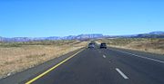
. The road heads east from the junction with SR 89 as a four-lane divided highway
Divided Highway
Divided Highway is a compilation album by American rock band The Doobie Brothers, released in 2003. . All tracks are taken from the albums Cycles and Brotherhood .-Track listing:...
with diamond interchange
Diamond interchange
A diamond interchange is a common type of road junction, used where a freeway crosses a minor road. The freeway itself is grade-separated from the minor road, one crossing the other over a bridge...
s located at most intersections. It continues as a divided highway until it reaches Fain Road in Prescott Valley
Prescott Valley, Arizona
Prescott Valley is a town in Yavapai County, Arizona, United States, just east of Prescott. Prescott Valley was the seventh fastest-growing place among all cities and towns in Arizona between 1990 and 2000...
. The route continues beyond this intersection as a two-lane undivided highway through desert.
Hairpin turn
A hairpin turn , named for its resemblance to a hairpin/bobby pin, is a bend in a road with a very acute inner angle, making it necessary for an oncoming vehicle to turn almost 180° to continue on the road. Such turns in ramps and trails may be called switchbacks in American English, by analogy...
s as the it climbs in elevation. Once SR 89A reaches passes over the mountains, it begins its descent into the Verde Valley
Verde Valley
The Verde Valley is a valley in central Arizona in the United States of America. The Verde River runs through it. It is overlooked by Mingus Mountain and the Mogollon Rim.- History :The first notice of this region appears in the report of one Espejo,...
. During its descent, SR 89A enters the town of Jerome
Jerome, Arizona
Jerome is a town in Yavapai County, Arizona, United States. According to 2006 Census Bureau estimates, the population of the town is 353.-History:...
. In Jerome, the highway provides access to the nearby Jerome State Historical Park.
Jerome to Sedona
Upon exiting Jerome, SR 89A heads northeast through the Verde Valley. After it enters the town of ClarkdaleClarkdale, Arizona
Clarkdale is a town in Yavapai County, Arizona, United States. According to 2006 Census Bureau estimates, the population of the town is 3,836.Clarkdale, formerly a mining town, is now largely a retirement community with an eye for the arts.-History:...
, it turns southeast at an intersection with Clarkdale Parkway. The route continues towards the southeast through Clarkdale before entering the town of Cottonwood
Cottonwood, Arizona
Cottonwood is a city in Yavapai County, Arizona, United States. According to 2006 Census Bureau estimates, the population of the city is 11,171.-Geography:Cottonwood is located at ....
. In Cottonwood, the highway follows the old alignment of Cottonwood Street before reaching an intersection with Main Street.
The historic route of 89A from Clarkdale to Cottonwood, when part of US 89A, ran through the old downtown areas of each city. From Jerome, the route continued along 11th Street (now Clarkdale Parkway), turning right at Main Street in Clarkdale, and then right again at Broadway. It continued past Tuzigoot National Monument
Tuzigoot National Monument
Tuzigoot National Monument preserves a 2 to 3 story pueblo ruin on the summit of a limestone and sandstone ridge just east of Clarkdale, Arizona, 120 feet above the Verde River floodplain. The pueblo has 110 rooms...
, becoming Main Street in Cottonwood, and providing access to Dead Horse Ranch State Park
Dead Horse Ranch State Park
Dead Horse Ranch State Park is a state park of Arizona, USA, on the Verde River in an area known as the Verde River Greenway. Located at approximately elevation, Dead Horse Ranch State Park covers of land with of hiking trails, 150 campground sites and several picnic areas, along with 23 group...
. The route intersects Cottonwood Street, where the bypass route now intersects Main Street. This portion is now signed as "Historic U.S. 89A."
Camp Verde, Arizona
Camp Verde is a town in Yavapai County, Arizona, United States. According to 2006 Census Bureau estimates, the population of the town is 10,610....
and I-17
Interstate 17
Interstate 17 , also known as the Black Canyon Freeway, is an intrastate Interstate Highway located entirely within the state of Arizona, United States. I-17's southern terminus lies within Phoenix, at Interstate 10, and its northern terminus is in Flagstaff, at Interstate 40...
. SR 89A then moves northeastward towards Sedona
Sedona, Arizona
Sedona is a city that straddles the county line between Coconino and Yavapai counties in the northern Verde Valley region of the U.S. state of Arizona...
.
As the highway leaves Cottonwood
Cottonwood, Arizona
Cottonwood is a city in Yavapai County, Arizona, United States. According to 2006 Census Bureau estimates, the population of the city is 11,171.-Geography:Cottonwood is located at ....
, it again becomes a divided highway north of Rocking Chair Road, heading into desert. Before reaching Sedona, SR 89A provides access to Red Rock State Park
Red Rock State Park
Red Rock State Park is a state park of Arizona, USA, featuring a red sandstone canyon outside the city of Sedona. This day-use park hosts numerous environmental education events for the public and for school or private groups.-Natural history:...
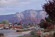
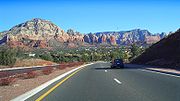
. The route remains a divided highway until it reaches Sedona, an arts and resort community known for its red sandstone
Sandstone
Sandstone is a sedimentary rock composed mainly of sand-sized minerals or rock grains.Most sandstone is composed of quartz and/or feldspar because these are the most common minerals in the Earth's crust. Like sand, sandstone may be any colour, but the most common colours are tan, brown, yellow,...
formations. As it enters the city of Sedona, the route is known as the Si Birch Memorial Highway. The route continues east through Sedona, providing access to the Sedona Airport
Sedona Airport
Sedona Airport is a small non-towered airport located two miles southwest of the central business district of Sedona, a city in Yavapai County, Arizona, United States. The airport covers and has one runway and one helipad.Although most U.S...
. SR 89A continues towards the east through Sedona to an intersection with SR 179, which heads south from this intersection through the southern part of Sedona to provide access to I-17
Interstate 17
Interstate 17 , also known as the Black Canyon Freeway, is an intrastate Interstate Highway located entirely within the state of Arizona, United States. I-17's southern terminus lies within Phoenix, at Interstate 10, and its northern terminus is in Flagstaff, at Interstate 40...
.
Sedona to Flagstaff
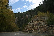
The highway heads northeast into a wooded area from Sedona and follows Oak Creek as it enters Oak Creek Canyon. SR 89A then curves to the north as it follows the creek and provides access to Slide Rock State ParkSlide Rock State Park
Slide Rock State Park is a state park of Arizona, USA, taking its name from a natural water slide formed by the slippery bed of Oak Creek. The park is located in Oak Creek Canyon north of Sedona. Slide Rock State Park is located on Coconino National Forest land and is co-managed by the Arizona...
along this portion of the highway. The roadway leaves the creek as it begins to ascend through the canyon. Upon ascending, the road goes through a series of hairpin turn
Hairpin turn
A hairpin turn , named for its resemblance to a hairpin/bobby pin, is a bend in a road with a very acute inner angle, making it necessary for an oncoming vehicle to turn almost 180° to continue on the road. Such turns in ramps and trails may be called switchbacks in American English, by analogy...
s towards the Mogollon Rim
Mogollon Rim
The Mogollon Rim is a topographical and geological feature running across the U.S. state of Arizona. It extends approximately from northern Yavapai County eastward to near the border with New Mexico.-Description:...
. The roadway continues northward away from the canyon towards Flagstaff
Flagstaff, Arizona
Flagstaff is a city located in northern Arizona, in the southwestern United States. In 2010, the city's population was 65,870. The population of the Metropolitan Statistical Area was at 134,421 in 2010. It is the county seat of Coconino County...
. It curves northeastward as it passes to the west of the Forest Highlands Gold Club. The route continues to the northeast to I-17 in Flagstaff near Flagstaff Pulliam Airport
Flagstaff Pulliam Airport
Flagstaff Pulliam Airport is a city-owned public-use airport located four nautical miles south of the central business district of Flagstaff, a city in Coconino County, Arizona, United States...
. SR 89A begins to run concurrently
Concurrency (road)
A concurrency, overlap, or coincidence in a road network is an instance of one physical road bearing two or more different highway, motorway, or other route numbers...
with I-17
Interstate 17
Interstate 17 , also known as the Black Canyon Freeway, is an intrastate Interstate Highway located entirely within the state of Arizona, United States. I-17's southern terminus lies within Phoenix, at Interstate 10, and its northern terminus is in Flagstaff, at Interstate 40...
as a freeway northward. The two highways continue north to an interchange with I-40
Interstate 40 in Arizona
Interstate 40 is an east–west Interstate Highway that has a section in the U.S. state of Arizona connecting sections in California to New Mexico. It enters Arizona from the west at a crossing of the Colorado River southwest of Kingman...
, where I-17 terminates. The route continues north along Milton Road, passing to the west of Northern Arizona University
Northern Arizona University
Northern Arizona University is a public university located in Flagstaff, Arizona, United States. It is accredited by the North Central Association of Colleges and Schools, and has 39 satellite campuses in the state of Arizona. The university offers both undergraduate and graduate degrees.As of...
before reaching its northern terminus at Interstate 40 Business in Flagstaff.
History
Arizona Department of Transportation
The Arizona Department of Transportation is an Arizona state government agency charged with facilitating mobility within the state. In addition to managing the state's highway system, the agency is also involved with public transportation and municipal airports...
(ADOT). At the time, only the portion from Prescott to Clarkdale was built, but the remaining portion to Flagstaff had been planned. By 1929, the highway had been extended north to Sedona, although the entire highway was not paved at this time. A graded dirt road was built the following year between Flagstaff and Sedona. The southern half of the section between Sedona and Flagstaff had been improved to a gravel road by 1934, with the northern half under construction. The next year, the construction on the northern section near Flagstaff was complete. The southern end of the highway near Prescott and the section between Jerome and Cottonwood had been paved by this time. By 1938, the entire route had been paved.
By 1941, the highway was redesignated from SR 79 to US 89A. Before the establishment of the route for I-17
Interstate 17
Interstate 17 , also known as the Black Canyon Freeway, is an intrastate Interstate Highway located entirely within the state of Arizona, United States. I-17's southern terminus lies within Phoenix, at Interstate 10, and its northern terminus is in Flagstaff, at Interstate 40...
, the only route to Flagstaff was through Prescott. There were two routes available: US 89A through Jerome, Cottonwood, Clarkdale, Sedona and Oak Creek Canyon or north through Chino Valley via US 89 to US 66. Upon the completion of I-17 by 1971, the section concurrent with that freeway was upgraded to Interstate standards. The route was redesignated from US 89A to SR 89A in 1993.
Junction list
{| class=wikitable!County
!Location
!Mile
!Exit
!Junction
!Notes
|-
|rowspan=8|Yavapai
Yavapai County, Arizona
-2010:Whereas according to the 2010 U.S. Census Bureau:*89.3% White*0.6% Black*1.7% Native American*0.8% Asian*0.1% Native Hawaiian or Pacific Islander*2.5% Two or more races*5.0% Other races*13.6% Hispanic or Latino -2000:...
|rowspan=3|Prescott
Prescott, Arizona
Prescott is a city in Yavapai County, Arizona, USA. It was designated "Arizona's Christmas City" by Arizona Governor Rose Mofford in the late 1980s....
|0.00
|317
|
|
|-
|0.96
|318
|Larry Caldwell Drive
|
|-
|1.42
|319
|Granite Dells Parkway
|
|-
|rowspan=4|Prescott Valley
Prescott Valley, Arizona
Prescott Valley is a town in Yavapai County, Arizona, United States, just east of Prescott. Prescott Valley was the seventh fastest-growing place among all cities and towns in Arizona between 1990 and 2000...
|4.21
|322
|Glassford Hill Road
|
|-
|4.96
|323
|Viewpoint Drive
|
|-
|5.62
|
|Fain Road
|Y interchange, Fain Road continues 8 miles to meet
|-
|
|colspan=3 align="center"|End freeway
|-
|Cottonwood
Cottonwood, Arizona
Cottonwood is a city in Yavapai County, Arizona, United States. According to 2006 Census Bureau estimates, the population of the city is 11,171.-Geography:Cottonwood is located at ....
|36.23
|
|
|
|-
|rowspan=4|Coconino
Coconino County, Arizona
-2010:Whereas according to the 2010 U.S. Census Bureau:*61.7% White*1.2% Black*27.3% Native American*1.4% Asian*0.1% Native Hawaiian or Pacific Islander*3.1% Two or more races*5.2% Other races*13.5% Hispanic or Latino -2000:...
|Sedona
Sedona, Arizona
Sedona is a city that straddles the county line between Coconino and Yavapai counties in the northern Verde Valley region of the U.S. state of Arizona...
|54.80
|
|
|
|-
|rowspan=3|Flagstaff
Flagstaff, Arizona
Flagstaff is a city located in northern Arizona, in the southwestern United States. In 2010, the city's population was 65,870. The population of the Metropolitan Statistical Area was at 134,421 in 2010. It is the county seat of Coconino County...
|79.66
|
|
|South end of I-17 overlap
|-
|82.62
|
| – Los Angeles
Los Ángeles
Los Ángeles is the capital of the province of Biobío, in the commune of the same name, in Region VIII , in the center-south of Chile. It is located between the Laja and Biobío rivers. The population is 123,445 inhabitants...
, Albuquerque
Albuquerque, New Mexico
Albuquerque is the largest city in the state of New Mexico, United States. It is the county seat of Bernalillo County and is situated in the central part of the state, straddling the Rio Grande. The city population was 545,852 as of the 2010 Census and ranks as the 32nd-largest city in the U.S. As...
|North end of I-17 overlap
|-
|83.85
|
| – Los Angeles
Los Ángeles
Los Ángeles is the capital of the province of Biobío, in the commune of the same name, in Region VIII , in the center-south of Chile. It is located between the Laja and Biobío rivers. The population is 123,445 inhabitants...
, Page
Page, Arizona
Page is a city in Coconino County, Arizona, United States, near the Glen Canyon Dam and Lake Powell. According to 2005 Census Bureau estimates, the population of the city is 6,794.-Geography:Page is located at ....
, Grand Canyon
Grand Canyon
The Grand Canyon is a steep-sided canyon carved by the Colorado River in the United States in the state of Arizona. It is largely contained within the Grand Canyon National Park, the 15th national park in the United States...
|Old US 66