
.gif)
State Route 51 (Arizona)
Encyclopedia
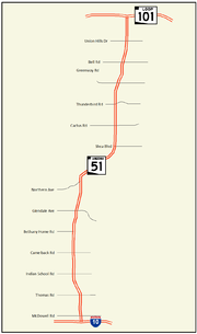
State Route 51 also known as the Piestewa Freeway, is a numbered state highway
in Phoenix
, Arizona
. It connects Interstate 10
in Downtown Phoenix
with Loop 101 on the north side of Phoenix, making it one of the area's major freeways. It is a largely north–south route and is known for traversing the Piestewa Peak
Recreation Area. Rapid growth and increased traffic demand on the east side of Metro Phoenix
made the Piestewa Freeway necessary. The freeway was named after Lori Piestewa
, the first known Native American
woman to die in combat for the U.S. Military. Prior to this time, the freeway was known as the Squaw Peak Parkway, a name considered offensive by many Native Americans.
The freeway was proposed at least as far back as 1955. Events in the planning of the freeway have led to speculation that the freeway was intended to become part of a never-constructed Interstate 510.
and Loop 202
immediately east of downtown Phoenix
. It heads north from the interchange through the northern sections of Phoenix. The freeway travels through some major areas of Phoenix, and past some major services such as the Phoenix Children's Hospital, Arizona Heart Hospital and Heart Institute, and the Camelback Colonnade at 20th Street and Camelback Road. The highway then begins to climb to the top of the Dreamy Draw, a mountain passage between Piestewa Peak
and North Mountain, before descending into the Paradise Valley area of North Phoenix. It reaches its northern terminus at an interchange with Loop 101 in northern Phoenix.
, included a spur freeway from what would become Interstate 10, proceeding north along a route similar to the modern Piestewa freeway.
 The routing of the freeway later appeared in route logs in 1968 under the designation of State Route 510 and the name Squaw Peak Freeway. This has led to speculation among some roadgeek
s that the road was originally intended to be part of the Interstate Highway System, and designated I-510.
The freeway was originally named the Squaw Peak Parkway. The modern usage of the word squaw
, which can be perceived as a derogatory term for Native American women, had led to guidelines from the U.S. Board on Geographic Names that the word should be phased out of the names of natural features. In 2003, Governor Janet Napolitano
announced her intent to rename the peak for which the freeway was named.
That same year, U.S. Army specialist and Arizona native Lori Piestewa
was killed in the 2003 invasion of Iraq
. According to U.S. Military records, Piestewa was the first known Native American woman to be killed on foreign soil while serving in combat for the military. As such, Governor Napolitano thought this was an appropriate new name for both the peak and the freeway.
The original five miles (8 km) of the freeway between McDowell Rd and Glendale Ave were constructed by the city of Phoenix (as the Squaw Peak Parkway) between 1986 and 1991. The first overpass
to be completed was in 1986 at Osborn Road. In 1987, the bridge over the Grand Canal had been completed, as well as the overpass at McDowell Road and the southbound connector to eastbound I-10. Also completed in 1987 were the overpasses at Colter Street and Missouri Avenue that passed over the freeway. Several more overpasses were completed in 1988 including those located at Indian School Road, Highland Avenue, Camelback Road and Bethany Home Road. Also in 1988, the state established a corridor for the freeway from Glendale Avenue north to Loop 101. In 1989, the bridge over the Arizona Canal
was complete, as well as the overpass at Thomas Road. The southbound Route 51 connector ramp to eastbound Loop 202 and the 20th Street overpass were completed in 1990. The city of Phoenix had the freeway completed as far north as Glendale Avenue in 1991.
During much of the road's early days in the 1990s, several decorative pots were mounted on top of the noise mitigation
walls, which were a source of controversy at the time of their installation due to cost and aesthetics. One resident installed a gold toilet in protest. They were all taken down during the ADOT reconstruction project between McDowell Rd and Shea Blvd in 2000, however.
In 1992, the southern portion was handed over to the Arizona Department of Transportation
. Since then, it has been extended to Loop 101 and retrofitted with rubberized asphalt
, standardized signage, an additional general purpose to create three lanes in each direction, and a new high occupancy vehicle lane up to Loop 101.
Starting in 2007, construction began to widen the Piestewa Freeway between Shea Blvd and the Loop 101 interchange to include a high occupancy vehicle lane in each direction and on ramps to Loop 101 eastbound. Work was completed in the summer of 2008.
State highway
State highway, state road or state route can refer to one of three related concepts, two of them related to a state or provincial government in a country that is divided into states or provinces :#A...
in Phoenix
Phoenix, Arizona
Phoenix is the capital, and largest city, of the U.S. state of Arizona, as well as the sixth most populated city in the United States. Phoenix is home to 1,445,632 people according to the official 2010 U.S. Census Bureau data...
, Arizona
Arizona
Arizona ; is a state located in the southwestern region of the United States. It is also part of the western United States and the mountain west. The capital and largest city is Phoenix...
. It connects Interstate 10
Interstate 10 in Arizona
In the U.S. state of Arizona, Interstate 10, the major east–west Interstate Highway in the southern United States, runs east from California, enters Arizona and continues through Phoenix and Tucson and exits at the border with New Mexico.-Route description:...
in Downtown Phoenix
Downtown Phoenix
Downtown Phoenix is the central business district of Phoenix, Arizona, United States. It is located near the geographic center of the Phoenix metropolitan area or Valley of the Sun. Phoenix, being the county seat of Maricopa County and the capital of Arizona, serves as the center of politics,...
with Loop 101 on the north side of Phoenix, making it one of the area's major freeways. It is a largely north–south route and is known for traversing the Piestewa Peak
Piestewa Peak
Piestewa Peak , at 2608 feet is the second highest point in the Phoenix Mountains, after Camelback Mountain, and the third highest in the city of Phoenix, Arizona. It is located in the Phoenix Mountain Preserve. Piestewa Peak is named in honor of Army Spc...
Recreation Area. Rapid growth and increased traffic demand on the east side of Metro Phoenix
Phoenix Metropolitan Area
The Phoenix metropolitan area, often referred to as The Valley of the Sun, is a metropolitan area, centered on the city of Phoenix, that includes much of the central part of the US state of Arizona...
made the Piestewa Freeway necessary. The freeway was named after Lori Piestewa
Lori Piestewa
SPC Lori Ann Piestewa was a U.S. Army Quartermaster Corps soldier killed during the same Iraqi Army attack in which fellow soldiers Shoshana Johnson and Jessica Lynch sustained injuries. A member of the Hopi tribe, Piestewa was the first Native American woman in history to die in combat while...
, the first known Native American
Indigenous peoples of the Americas
The indigenous peoples of the Americas are the pre-Columbian inhabitants of North and South America, their descendants and other ethnic groups who are identified with those peoples. Indigenous peoples are known in Canada as Aboriginal peoples, and in the United States as Native Americans...
woman to die in combat for the U.S. Military. Prior to this time, the freeway was known as the Squaw Peak Parkway, a name considered offensive by many Native Americans.
The freeway was proposed at least as far back as 1955. Events in the planning of the freeway have led to speculation that the freeway was intended to become part of a never-constructed Interstate 510.
Route description
The southern terminus of Route 51 is located at an interchange with I-10Interstate 10 in Arizona
In the U.S. state of Arizona, Interstate 10, the major east–west Interstate Highway in the southern United States, runs east from California, enters Arizona and continues through Phoenix and Tucson and exits at the border with New Mexico.-Route description:...
and Loop 202
Arizona State Route 202
State Route 202, or Loop 202, is the beltway encompassing the eastern Phoenix, Arizona, United States Metropolitan area. It navigates and surrounds the cities of Tempe, Mesa, Chandler, and Gilbert, making it very vital to the area freeway system...
immediately east of downtown Phoenix
Phoenix, Arizona
Phoenix is the capital, and largest city, of the U.S. state of Arizona, as well as the sixth most populated city in the United States. Phoenix is home to 1,445,632 people according to the official 2010 U.S. Census Bureau data...
. It heads north from the interchange through the northern sections of Phoenix. The freeway travels through some major areas of Phoenix, and past some major services such as the Phoenix Children's Hospital, Arizona Heart Hospital and Heart Institute, and the Camelback Colonnade at 20th Street and Camelback Road. The highway then begins to climb to the top of the Dreamy Draw, a mountain passage between Piestewa Peak
Piestewa Peak
Piestewa Peak , at 2608 feet is the second highest point in the Phoenix Mountains, after Camelback Mountain, and the third highest in the city of Phoenix, Arizona. It is located in the Phoenix Mountain Preserve. Piestewa Peak is named in honor of Army Spc...
and North Mountain, before descending into the Paradise Valley area of North Phoenix. It reaches its northern terminus at an interchange with Loop 101 in northern Phoenix.
History
General Location of National System of Interstate Highways, a 1955 proposal for what would become the Interstate Highway SystemInterstate Highway System
The Dwight D. Eisenhower National System of Interstate and Defense Highways, , is a network of limited-access roads including freeways, highways, and expressways forming part of the National Highway System of the United States of America...
, included a spur freeway from what would become Interstate 10, proceeding north along a route similar to the modern Piestewa freeway.
Roadgeek
A roadgeek is an individual involved in "roadgeeking" or "road enthusiasm"—an interest in roads, and especially going on road trips, as a hobby...
s that the road was originally intended to be part of the Interstate Highway System, and designated I-510.
The freeway was originally named the Squaw Peak Parkway. The modern usage of the word squaw
Squaw
Squaw is an English language loan-word, used as a noun or adjective, whose present meaning is an indigenous woman of North America. It is derived from the eastern Algonquian morpheme meaning 'woman' that appears in numerous Algonquian languages variously spelled squa, skwa, esqua, sqeh, skwe, que,...
, which can be perceived as a derogatory term for Native American women, had led to guidelines from the U.S. Board on Geographic Names that the word should be phased out of the names of natural features. In 2003, Governor Janet Napolitano
Janet Napolitano
Janet Napolitano is the third and current United States Secretary of Homeland Security, serving in the administration of President Barack Obama. She is the fourth person to hold the position, which was created after the 9/11 terrorist attacks. A member of the Democratic Party, she was the 21st...
announced her intent to rename the peak for which the freeway was named.
That same year, U.S. Army specialist and Arizona native Lori Piestewa
Lori Piestewa
SPC Lori Ann Piestewa was a U.S. Army Quartermaster Corps soldier killed during the same Iraqi Army attack in which fellow soldiers Shoshana Johnson and Jessica Lynch sustained injuries. A member of the Hopi tribe, Piestewa was the first Native American woman in history to die in combat while...
was killed in the 2003 invasion of Iraq
2003 invasion of Iraq
The 2003 invasion of Iraq , was the start of the conflict known as the Iraq War, or Operation Iraqi Freedom, in which a combined force of troops from the United States, the United Kingdom, Australia and Poland invaded Iraq and toppled the regime of Saddam Hussein in 21 days of major combat operations...
. According to U.S. Military records, Piestewa was the first known Native American woman to be killed on foreign soil while serving in combat for the military. As such, Governor Napolitano thought this was an appropriate new name for both the peak and the freeway.
The original five miles (8 km) of the freeway between McDowell Rd and Glendale Ave were constructed by the city of Phoenix (as the Squaw Peak Parkway) between 1986 and 1991. The first overpass
Overpass
An overpass is a bridge, road, railway or similar structure that crosses over another road or railway...
to be completed was in 1986 at Osborn Road. In 1987, the bridge over the Grand Canal had been completed, as well as the overpass at McDowell Road and the southbound connector to eastbound I-10. Also completed in 1987 were the overpasses at Colter Street and Missouri Avenue that passed over the freeway. Several more overpasses were completed in 1988 including those located at Indian School Road, Highland Avenue, Camelback Road and Bethany Home Road. Also in 1988, the state established a corridor for the freeway from Glendale Avenue north to Loop 101. In 1989, the bridge over the Arizona Canal
Arizona Canal
The Arizona Canal is a major canal in central Maricopa County that led to the founding of several communities, now among the wealthier neighborhoods of suburban Phoenix, in the late 1880s. Flood irrigation of residential yards is still common in these neighborhoods, using a system of lateral...
was complete, as well as the overpass at Thomas Road. The southbound Route 51 connector ramp to eastbound Loop 202 and the 20th Street overpass were completed in 1990. The city of Phoenix had the freeway completed as far north as Glendale Avenue in 1991.
During much of the road's early days in the 1990s, several decorative pots were mounted on top of the noise mitigation
Noise mitigation
Noise mitigation is a set of strategies to reduce noise pollution. The main areas of noise mitigation or abatement are: transportation noise control, architectural design, and occupational noise control...
walls, which were a source of controversy at the time of their installation due to cost and aesthetics. One resident installed a gold toilet in protest. They were all taken down during the ADOT reconstruction project between McDowell Rd and Shea Blvd in 2000, however.
In 1992, the southern portion was handed over to the Arizona Department of Transportation
Arizona Department of Transportation
The Arizona Department of Transportation is an Arizona state government agency charged with facilitating mobility within the state. In addition to managing the state's highway system, the agency is also involved with public transportation and municipal airports...
. Since then, it has been extended to Loop 101 and retrofitted with rubberized asphalt
Rubberized asphalt
Rubberized asphalt concrete , also known as asphalt rubber or just rubberized asphalt, is pavement material that consists of regular asphalt concrete mixed with crumb rubber–ground, used tires that might otherwise be discarded, taking up space in landfills, if they were not re-directed for use as...
, standardized signage, an additional general purpose to create three lanes in each direction, and a new high occupancy vehicle lane up to Loop 101.
Starting in 2007, construction began to widen the Piestewa Freeway between Shea Blvd and the Loop 101 interchange to include a high occupancy vehicle lane in each direction and on ramps to Loop 101 eastbound. Work was completed in the summer of 2008.
Exit list
External links
- Piestewa Freeway from Arizona Roads
- SR 51, also from Arizona Roads