

State Route 447 (Nevada)
Encyclopedia
State Route 447 is a state highway in the U.S. state of Nevada
. The highway is almost entirely within Washoe County
but does for a brief time enter Pershing County, Nevada
The highway begins at a junction with SR 427
, a historical routing of US 40, in Wadsworth, Nevada
. The highway ends in Gerlach, Nevada. Though passing through extremely remote and desolate areas of Nevada the highway has recently gained fame as the primary route to access the Black Rock Desert
, the site of the annual Burning Man
festival. A 4.5 miles (7.2 km) portion of this highway, along with portions of SR 445
and SR 446
, has been designated the Pyramid Lake Scenic Byway.
Ten solar energy arrays, totaling 451 kilowatts, have been installed along Nevada 447 with the help of Burning Man-related not-for-profit Black Rock Solar and Nevada's "Solar Generations" rebate program.
Nevada Governor Jim Gibbons issued an August 18, 2010 proclamation declaring the road "to be America's Solar Highway"
, and passes along the east side of the river's terminus at Pyramid Lake near Nixon
. The highway continues north following the western edge of Winnemucca Lake
, a dry lake that once also was the terminus of the Truckee river. During this portion the highway straddles the Washoe/Pershing County line.
The highway enters the Black Rock Desert
just before arriving at Empire, a city founded on processing gypsum
extracted from the desert. The highway ends 0.375 mile (0.6035025 km) north of crossing the Union Pacific Railroad
's Feather River Route
in Gerlach.
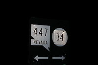
Just past where the official designation ends is the turn off for former State Route 34
, which is used to access the large Playa
of the Black Rock Desert and the site of the annual Burning Man Festival
.
to the California State Line near the Lassen
/Modoc
county line. This road is frequently called the Gerlach-Cederville
Road. Some maps erroneously list this road as part of State Route 447.
from Gerlach to Wadsworth
, and former SR 81 from Gerlach to the State line which today is present CR 447
 This major intersections table lists junctions for both State Route 447 and Washoe County Route 447. All junctions are located in Washoe County
.
Nevada
Nevada is a state in the western, mountain west, and southwestern regions of the United States. With an area of and a population of about 2.7 million, it is the 7th-largest and 35th-most populous state. Over two-thirds of Nevada's people live in the Las Vegas metropolitan area, which contains its...
. The highway is almost entirely within Washoe County
Washoe County, Nevada
Washoe County is a county located in the U.S. state of Nevada. The population was 421,407 at the 2010 census. Its county seat is Reno. Washoe County includes the Reno-Sparks metropolitan area.-History:...
but does for a brief time enter Pershing County, Nevada
Pershing County, Nevada
Pershing County is a county located in the U.S. state of Nevada. As of the 2000 census, the population was 6,693. Its county seat is Lovelock. The county was named after army general John J. Pershing . It was formed from Humboldt County in 1919, and the last county to be established in...
The highway begins at a junction with SR 427
Nevada State Route 427
State Route 427 is a state highway in the U.S. state of Nevada. It connects the community of Wadsworth in eastern Washoe County to the city of Fernley in western Lyon County. SR 427 comprises the former routing of U.S. Route 40 through the towns it serves...
, a historical routing of US 40, in Wadsworth, Nevada
Wadsworth, Nevada
Wadsworth is a census-designated place in Washoe County, Nevada, United States. The population was 881 at the 2000 census. It is part of the Reno–Sparks Metropolitan Statistical Area. The town was named for General James S. Wadsworth, a Civil War general killed at the battle of the...
. The highway ends in Gerlach, Nevada. Though passing through extremely remote and desolate areas of Nevada the highway has recently gained fame as the primary route to access the Black Rock Desert
Black Rock Desert
The Black Rock Desert is an arid region in the northern Nevada section of the Great Basin with a lakebed that is a dry remnant of Pleistocene Lake Lahontan...
, the site of the annual Burning Man
Burning Man
Burning Man is a week-long annual event held in the Black Rock Desert in northern Nevada, in the United States. The event starts on the Monday before the American Labor Day holiday, and ends on the holiday itself. It takes its name from the ritual burning of a large wooden effigy on Saturday evening...
festival. A 4.5 miles (7.2 km) portion of this highway, along with portions of SR 445
Nevada State Route 445
State Route 445 is a state highway in Washoe County, Nevada. The route follows Pyramid Way, a major thoroughfare in the city of Sparks, and connects the Reno metropolitan area to Pyramid Lake . The route is designated a Nevada Scenic Byway....
and SR 446
Nevada State Route 446
State Route 446 , is a state route that runs from SR 445 to SR 447 ....
, has been designated the Pyramid Lake Scenic Byway.
Ten solar energy arrays, totaling 451 kilowatts, have been installed along Nevada 447 with the help of Burning Man-related not-for-profit Black Rock Solar and Nevada's "Solar Generations" rebate program.
Nevada Governor Jim Gibbons issued an August 18, 2010 proclamation declaring the road "to be America's Solar Highway"
Route description
The route begins at a junction with Old US 40 in Wadsworth. The highway proceeds north following the path of the Truckee RiverTruckee River
The Truckee River is a stream in the U.S. states of California and Nevada. The river is about long. Its endorheic drainage basin is about , of which about are in Nevada. The Truckee is the sole outlet of Lake Tahoe and drains part of the high Sierra Nevada, emptying into Pyramid Lake in the Great...
, and passes along the east side of the river's terminus at Pyramid Lake near Nixon
Nixon, Nevada
Nixon is a census-designated place in Washoe County, Nevada, USA. The population was 418 at the 2000 census. It is part of the Reno–Sparks Metropolitan Statistical Area...
. The highway continues north following the western edge of Winnemucca Lake
Winnemucca Lake
Winnemucca Lake, just east of Pyramid Lake in the northwestern portion of the U.S. state of Nevada is on the dividing line between Washoe County and Pershing County counties.- Geography :...
, a dry lake that once also was the terminus of the Truckee river. During this portion the highway straddles the Washoe/Pershing County line.
The highway enters the Black Rock Desert
Black Rock Desert
The Black Rock Desert is an arid region in the northern Nevada section of the Great Basin with a lakebed that is a dry remnant of Pleistocene Lake Lahontan...
just before arriving at Empire, a city founded on processing gypsum
Gypsum
Gypsum is a very soft sulfate mineral composed of calcium sulfate dihydrate, with the chemical formula CaSO4·2H2O. It is found in alabaster, a decorative stone used in Ancient Egypt. It is the second softest mineral on the Mohs Hardness Scale...
extracted from the desert. The highway ends 0.375 mile (0.6035025 km) north of crossing the Union Pacific Railroad
Union Pacific Railroad
The Union Pacific Railroad , headquartered in Omaha, Nebraska, is the largest railroad network in the United States. James R. Young is president, CEO and Chairman....
's Feather River Route
Feather River Route
The Feather River Route is a rail line that was built and operated by the Western Pacific Railroad. It was constructed between 1906 and 1909, and connects the cities of Oakland, California, and Salt Lake City, Utah...
in Gerlach.
Just past where the official designation ends is the turn off for former State Route 34
Nevada State Route 34
Former SR 34 is a signed decommissioned State highway in Nevada from prior to the state's highway restructuring in 1978. Today a portion of former SR 34 is maintained by the Washoe County as a county highway with the not well known designation CR 34...
, which is used to access the large Playa
Sink (geography)
A geographic sink is a depression within an endorheic basin where water collects with no visible outlet. Instead of discharging, the collected water is lost due to evaporation and/or penetration...
of the Black Rock Desert and the site of the annual Burning Man Festival
Burning Man
Burning Man is a week-long annual event held in the Black Rock Desert in northern Nevada, in the United States. The event starts on the Monday before the American Labor Day holiday, and ends on the holiday itself. It takes its name from the ritual burning of a large wooden effigy on Saturday evening...
.
County Route 447
The State highway officially ends here, becoming CR 447 where the roadbed continues as a Washoe county roadto the California State Line near the Lassen
Lassen County, California
Lassen County is a county located in the northeastern portion of the U.S. state of California. As of the 2010 census, the population was 34,895, up from 33,828 at the 2000 census...
/Modoc
Modoc County, California
Modoc County is a county located in the far northeast corner of the U.S. state of California, bounded by the state of Oregon to the north and the state of Nevada to the east. As of the 2010 census, its population was 9,686, up from 9,449 at the 2000 census. The current county seat is Alturas, the...
county line. This road is frequently called the Gerlach-Cederville
Cedarville, California
Cedarville is a census-designated place in Modoc County, California. It is located east of Alturas, at an elevation of 4652 feet ....
Road. Some maps erroneously list this road as part of State Route 447.
History
The present day highway before 1978 was formed from part of SR 34Nevada State Route 34
Former SR 34 is a signed decommissioned State highway in Nevada from prior to the state's highway restructuring in 1978. Today a portion of former SR 34 is maintained by the Washoe County as a county highway with the not well known designation CR 34...
from Gerlach to Wadsworth
Wadsworth, Nevada
Wadsworth is a census-designated place in Washoe County, Nevada, United States. The population was 881 at the 2000 census. It is part of the Reno–Sparks Metropolitan Statistical Area. The town was named for General James S. Wadsworth, a Civil War general killed at the battle of the...
, and former SR 81 from Gerlach to the State line which today is present CR 447
Major intersections
Washoe County, Nevada
Washoe County is a county located in the U.S. state of Nevada. The population was 421,407 at the 2010 census. Its county seat is Reno. Washoe County includes the Reno-Sparks metropolitan area.-History:...
.
| Location | Mile |
Junction | Notes |
|---|---|---|---|
| Wadsworth Wadsworth, Nevada Wadsworth is a census-designated place in Washoe County, Nevada, United States. The population was 881 at the 2000 census. It is part of the Reno–Sparks Metropolitan Statistical Area. The town was named for General James S. Wadsworth, a Civil War general killed at the battle of the... |
0.00 | ||
| Nixon Nixon, Nevada Nixon is a census-designated place in Washoe County, Nevada, USA. The population was 418 at the 2000 census. It is part of the Reno–Sparks Metropolitan Statistical Area... |
, Pyramid Lake State Park | ||
| Gerlach | 74.64 | SR 447 ends and CR 447 begins | |
| 75 |  Nevada State Route 34 Former SR 34 is a signed decommissioned State highway in Nevada from prior to the state's highway restructuring in 1978. Today a portion of former SR 34 is maintained by the Washoe County as a county highway with the not well known designation CR 34... – Vya Vya, Nevada Vya, Nevada is a small ghost town located in Washoe County, in northwestern Nevada. It is to the east of the California state line, about 10 miles plus. Not much remains of the small town, which essentially died in the 1920s. Just two wooden buildings can still be seen—the Vya Post Office and Library... |
Former SR 34 | |
| 130 | Surprise Valley Rd – Eagleville Eagleville, Modoc County, California Eagleville is a census-designated place in Modoc County, California. It is located east-southeast of Alturas, at an elevation of 4642 feet . The population was 59 at the 2010 census.... , Cederville Cedarville, California Cedarville is a census-designated place in Modoc County, California. It is located east of Alturas, at an elevation of 4652 feet .... |
California California California is a state located on the West Coast of the United States. It is by far the most populous U.S. state, and the third-largest by land area... state line |
|