

Nevada State Route 34
Encyclopedia
Decommissioned highway
A decommissioned highway is a highway that has been removed from service, shut down or has had its authorization as a federal or state highway removed. Decommissioning can include the complete or partial demolition or abandonment of an old highway structure because the old roadway has lost its...
in Nevada
Nevada
Nevada is a state in the western, mountain west, and southwestern regions of the United States. With an area of and a population of about 2.7 million, it is the 7th-largest and 35th-most populous state. Over two-thirds of Nevada's people live in the Las Vegas metropolitan area, which contains its...
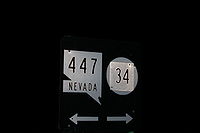
from prior to the state's highway restructuring in 1978. Today a portion of former SR 34 is maintained by the Washoe County
Washoe County, Nevada
Washoe County is a county located in the U.S. state of Nevada. The population was 421,407 at the 2010 census. Its county seat is Reno. Washoe County includes the Reno-Sparks metropolitan area.-History:...
as a county highway with the not well known designation CR 34. A portion of State Route 447 was formerly SR 34, though the former SR 34 road bed is still used from Gerlach, Nevada to near Vya, Nevada
Vya, Nevada
Vya, Nevada is a small ghost town located in Washoe County, in northwestern Nevada. It is to the east of the California state line, about 10 miles plus. Not much remains of the small town, which essentially died in the 1920s. Just two wooden buildings can still be seen—the Vya Post Office and Library...
.
History
Before 1978 SR 34 followed present day SR 447 route, from Gerlach to Wadsworth, NevadaWadsworth, Nevada
Wadsworth is a census-designated place in Washoe County, Nevada, United States. The population was 881 at the 2000 census. It is part of the Reno–Sparks Metropolitan Statistical Area. The town was named for General James S. Wadsworth, a Civil War general killed at the battle of the...
.
Major intersections
| Location | Junction | Notes |
|---|---|
| Gerlach |  |
|-
|
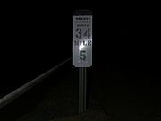
!colspan=2|CR 34 ends / Former SR 34 roadbed counties
|-
|Vya
|
|South end of SR 8A overlap
|-
|
|
|North end of SR 8A overlap
|-
|
!colspan=2|Oregon State line
Oregon
Oregon is a state in the Pacific Northwest region of the United States. It is located on the Pacific coast, with Washington to the north, California to the south, Nevada on the southeast and Idaho to the east. The Columbia and Snake rivers delineate much of Oregon's northern and eastern...
|-
|
|Coleman Valley Rd
|To
 OR 140 – Adel, Lakeview, Denio
|}