
.gif)
State Route 3 (Tennessee)
Encyclopedia
U.S. Route 51, mostly overlapped by the unsigned
State Route 3 (SR 3), is a north–south state highway
in the U.S. state
of Tennessee
, that is 135.9 miles (218.71 km) long. It begins in Shelby County
and ends in Obion County. The SR 3 designation is seen largely on mileposts.
The two places where US 51 and SR 3 differ are in Memphis, where US 51 has been moved to Danny Thomas Boulevard (State Route 1
/ State Route 4), while SR 3 remains on the one-way pair
of 2nd and 3rd Streets, and in South Fulton, where US 51 crosses the state line on State Route 215 to the Purchase Parkway
, while SR 3 remains on the old road, now U.S. Route 45.
and runs north through the cities of Millington
, Covington
, Henning
, Ripley
, Halls
, Dyersburg
, Troy
, Union City
, and South Fulton
. This highway crosses four interstate highways on its journey through the state and actually crosses Interstate 240
twice within the City of Memphis but interchanges with it only at Union Avenue. US 51 is the westernmost south–north United States Highway in the State of Tennessee. US 51 is an interstate standard facility from Dyersburg to South of Troy and then resuming interstate standard status north of Union City to South Fulton. US 51 is a four-lane or larger facility throughout the state with some sections north of Dyersburg carrying a 70 mi/h speed limit.
Near Henning is also the site of the Hatchie River
Bridge collapse on April 1, 1989 that killed 8 motorists when 3 spans of the structure collapsed. The 54-year old bridge was 45 miles (72.4 km) north of Memphis and carried the northbound lanes of US 51. Its collapse was the result of pier scour and movement of the river channel.
US 51 carries the Tennessee Scenic Parkway designation from its junction with SR 385 in Millington to SR 104 in Dyersburg and also carries the Great River Road
designation from US 64/US 70/US 79 in Memphis to SR 88 in Halls.
 US 51 traverses the counties shown in the table below.
. Plans currently call for Interstate 69 to run along the existing US 51 freeway from Dyersburg to Troy and from Union City to South Fulton. This section is part of SIU 7 for Interstate 69 and will require few changes beyond resigning the existing highway, however, a bypass
route around Troy and Union City will need to be built before this section of future Interstate 69 is completed. See Interstate 69 in Tennessee
for further information.
Unsigned highway
An unsigned highway is a highway that has been assigned a route number, but does not bear conventional road markings that would normally be used to identify the route with that number...
State Route 3 (SR 3), is a north–south state highway
State highway
State highway, state road or state route can refer to one of three related concepts, two of them related to a state or provincial government in a country that is divided into states or provinces :#A...
in the U.S. state
U.S. state
A U.S. state is any one of the 50 federated states of the United States of America that share sovereignty with the federal government. Because of this shared sovereignty, an American is a citizen both of the federal entity and of his or her state of domicile. Four states use the official title of...
of Tennessee
Tennessee
Tennessee is a U.S. state located in the Southeastern United States. It has a population of 6,346,105, making it the nation's 17th-largest state by population, and covers , making it the 36th-largest by total land area...
, that is 135.9 miles (218.71 km) long. It begins in Shelby County
Shelby County, Tennessee
Shelby County is a county located in the U.S. state of Tennessee. It is the state's largest both in terms of population and geographic area, with a population of 927,644 at the 2010 census...
and ends in Obion County. The SR 3 designation is seen largely on mileposts.
The two places where US 51 and SR 3 differ are in Memphis, where US 51 has been moved to Danny Thomas Boulevard (State Route 1
State Route 1 (Tennessee)
State Route 1 , known as the Memphis to Bristol Highway, is a mostly-unsigned state highway in the U.S. state of Tennessee that is 538 miles long. It stretches all the way from Memphis in the southwest corner of the state to Bristol in the northeast corner. Most of the route is overlaid on U.S....
/ State Route 4), while SR 3 remains on the one-way pair
One-way pair
A one-way pair, one-way couple, or just couplet is a pair of parallel, usually one-way streets that carry opposite directions of a signed route or major traffic flow, or sometimes opposite directions of a bus or streetcar route....
of 2nd and 3rd Streets, and in South Fulton, where US 51 crosses the state line on State Route 215 to the Purchase Parkway
Purchase Parkway
The Julian M. Carroll Purchase Parkway is a controlled-access highway running from Fulton, Kentucky to Calvert City, Kentucky, near Kentucky Dam, for a length of 52 miles...
, while SR 3 remains on the old road, now U.S. Route 45.
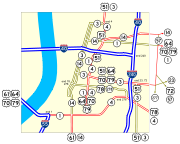
Route description
US 51 enters Tennessee at MemphisMemphis, Tennessee
Memphis is a city in the southwestern corner of the U.S. state of Tennessee, and the county seat of Shelby County. The city is located on the 4th Chickasaw Bluff, south of the confluence of the Wolf and Mississippi rivers....
and runs north through the cities of Millington
Millington, Tennessee
Millington is a city in Shelby County, Tennessee. As of the 2010 census, it had a population of 10,176. Millington was the home of the recently closed Memphis Motorsports Park. It was granted the title "Flag City Tennessee" by the Tennessee State Legislature. The Naval Support Activity Mid-South is...
, Covington
Covington, Tennessee
Covington is a city in central Tipton County in the State of Tennessee. Covington is the largest city and county seat of, Tipton County. Covington is located in one of just five counties of West Tennessee that are located along the Mississippi River, thus it is in extreme western Tennessee.This...
, Henning
Henning, Tennessee
Henning is a town in Lauderdale County, Tennessee, United States. The population was 970 at the 2000 census.-Geography:Henning is located at .According to the United States Census Bureau, the town has a total area of , all land....
, Ripley
Ripley, Tennessee
Ripley is a city in Lauderdale County, Tennessee, United States. The population was 7,844 at the 2000 census. It is the county seat of Lauderdale County...
, Halls
Halls, Tennessee
Halls is a town in Lauderdale County, Tennessee, United States. The population was 2,311 at the 2000 census.The town was founded in 1882. It is named after Hansford R. Hall, one of the founders...
, Dyersburg
Dyersburg, Tennessee
Dyersburg is a city in and the county seat of Dyer County, Tennessee, United States, north-northeast of Memphis on the Forked Deer River. The population was 17,145 at the 2010 census.-Geography:Dyersburg is located at...
, Troy
Troy, Tennessee
Troy is a town in Obion County, Tennessee, United States. The population was 1,273 at the 2000 census. It is part of the Union City, TN–KY Micropolitan Statistical Area.-Geography:...
, Union City
Union City, Tennessee
Union City is a city in Obion County, Tennessee, United States. The population was 10,876 at the 2000 census. It is the county seat of Obion County. The name comes from its location at the union of two railroads, one running roughly east-west and the other roughly north-south...
, and South Fulton
South Fulton, Tennessee
South Fulton is a city in Obion County, Tennessee, in the United States. The population was 2,517 at the 2000 census. It is part of the Union City, TN–KY Micropolitan Statistical Area.-Geography:South Fulton is located at ....
.
Interstate 240 (Tennessee)
Interstate 240 is an Interstate Highway in the U.S. state of Tennessee. Running or 31.0 km, it loops southward from Interstate 40 in east Memphis, then turning west at TN 385 . At I-55, the highway turns north and runs through midtown to end at I-40...
twice within the City of Memphis but interchanges with it only at Union Avenue. US 51 is the westernmost south–north United States Highway in the State of Tennessee. US 51 is an interstate standard facility from Dyersburg to South of Troy and then resuming interstate standard status north of Union City to South Fulton. US 51 is a four-lane or larger facility throughout the state with some sections north of Dyersburg carrying a 70 mi/h speed limit.
Near Henning is also the site of the Hatchie River
Hatchie River
The Hatchie River is a stream in northern Mississippi and southwestern Tennessee. It is of considerable geographic, cultural, and historic significance. In large measure this is because it is the only major stream of West Tennessee that has never been impounded, channelized, or otherwise...
Bridge collapse on April 1, 1989 that killed 8 motorists when 3 spans of the structure collapsed. The 54-year old bridge was 45 miles (72.4 km) north of Memphis and carried the northbound lanes of US 51. Its collapse was the result of pier scour and movement of the river channel.
US 51 carries the Tennessee Scenic Parkway designation from its junction with SR 385 in Millington to SR 104 in Dyersburg and also carries the Great River Road
Great River Road
The Great River Road is a collection of state, provincial, federal, and local roads which follow the course of the Mississippi River through ten states of the United States...
designation from US 64/US 70/US 79 in Memphis to SR 88 in Halls.
Counties traversed (south to north)
| Counties traversed by US 51 | ||
|---|---|---|
| County | miles | kilometers |
| Shelby Shelby County, Tennessee Shelby County is a county located in the U.S. state of Tennessee. It is the state's largest both in terms of population and geographic area, with a population of 927,644 at the 2010 census... |
33.1 | 53.2 |
| Tipton Tipton County, Tennessee Tipton County is a county located on the western end of the U.S. state of Tennessee. As of 2000, the population was 51,271. Its county seat is Covington. Tipton County is part of the Memphis, TN–MS–AR Metropolitan Statistical Area, centered on Shelby County, which borders Tipton on... |
22.2 | 35.6 |
| Lauderdale | 25.0 | 40.2 |
| Dyer | 24.7 | 39.7 |
| Obion | 30.9 | 49.7 |
History
Historic two-lane alignments of this highway from Henning north are represented by State Route 209, a portion of State Route 88, State Route 210, State Route 211, a portion of State Route 183 and State Route 184. From Memphis to Henning, most of the original two lane road was upgraded to four lane expressway in the 1960s.Future
Most of US 51 north of Dyersburg is expected to be upgraded as part of future Interstate 69Interstate 69
Interstate 69 is an Interstate Highway in the United States. It exists in two parts: a completed highway from Indianapolis, Indiana, northeast to the Canadian border in Port Huron, Michigan, and a mostly proposed extension southwest to the Mexican border in Texas...
. Plans currently call for Interstate 69 to run along the existing US 51 freeway from Dyersburg to Troy and from Union City to South Fulton. This section is part of SIU 7 for Interstate 69 and will require few changes beyond resigning the existing highway, however, a bypass
Bypass (road)
A bypass is a road or highway that avoids or "bypasses" a built-up area, town, or village, to let through traffic flow without interference from local traffic, to reduce congestion in the built-up area, and to improve road safety....
route around Troy and Union City will need to be built before this section of future Interstate 69 is completed. See Interstate 69 in Tennessee
Interstate 69 in Tennessee
The proposed Interstate 69 will pass through the western part of the U.S. state of Tennessee, serving the cities of Union City, Troy, Dyersburg, and Memphis. State officials are considering building parts of I-69 as a toll road...
for further information.
Major intersections
| County | Location | Mile | Intersects | Notes |
|---|---|---|---|---|
  (unsigned) begins at Mississippi (unsigned) begins at MississippiMississippi Mississippi is a U.S. state located in the Southern United States. Jackson is the state capital and largest city. The name of the state derives from the Mississippi River, which flows along its western boundary, whose name comes from the Ojibwe word misi-ziibi... State Line. SR 3 overlaps for 11.32 miles (18.2 km). |
||||
| Shelby Shelby County, Tennessee Shelby County is a county located in the U.S. state of Tennessee. It is the state's largest both in terms of population and geographic area, with a population of 927,644 at the 2010 census... |
Memphis Memphis, Tennessee Memphis is a city in the southwestern corner of the U.S. state of Tennessee, and the county seat of Shelby County. The city is located on the 4th Chickasaw Bluff, south of the confluence of the Wolf and Mississippi rivers.... |
1.80 | ||
| 4.70 | - St. Louis, Jackson Jackson, Mississippi Jackson is the capital and the most populous city of the US state of Mississippi. It is one of two county seats of Hinds County ,. The population of the city declined from 184,256 at the 2000 census to 173,514 at the 2010 census... |
|||
| 9.31 | ||||
| 9.90 | Begin US 64, US 70, US 79 overlap. SR 3 changes to primary designation and continues northbound overlap with US 51. | |||
| 10.15 | ||||
| 11.32 | End US 64, US 70, US 79 overlap. SR 1 overlap begins. | |||
| 12.12 | - Little Rock Little Rock, Arkansas Little Rock is the capital and the largest city of the U.S. state of Arkansas. The Metropolitan Statistical Area had a population of 699,757 people in the 2010 census... , Nashville Nashville, Tennessee Nashville is the capital of the U.S. state of Tennessee and the county seat of Davidson County. It is located on the Cumberland River in Davidson County, in the north-central part of the state. The city is a center for the health care, publishing, banking and transportation industries, and is home... |
|||
| 12.46 | Unsigned SR 1 overlap ends. Unsigned SR 4 overlap begins at North Parkway. | |||
| 12.49 | ||||
 (unsigned) continues northbound. Unsigned SR 3 changes to primary designation and resumes overlap for 121.77 miles (196 km). (unsigned) continues northbound. Unsigned SR 3 changes to primary designation and resumes overlap for 121.77 miles (196 km). |
||||
| 13.05 | (unsigned Unsigned highway An unsigned highway is a highway that has been assigned a route number, but does not bear conventional road markings that would normally be used to identify the route with that number... ) |
SR 4 overlap ends. SR 3 changes to primary designation and resumes overlap with US 51. | ||
| 15.51 | Eastbound Entrance. Highway is signed as "To I-40". | |||
| 18.37 | To Meeman-Shelby Forest State Park Meeman-Shelby Forest State Park Meeman-Shelby Forest State Park is a state park in Shelby County, Tennessee near Memphis, Tennessee, located in the Southeastern United States.... |
|||
| Millington Millington, Tennessee Millington is a city in Shelby County, Tennessee. As of the 2010 census, it had a population of 10,176. Millington was the home of the recently closed Memphis Motorsports Park. It was granted the title "Flag City Tennessee" by the Tennessee State Legislature. The Naval Support Activity Mid-South is... |
26.71 | |||
| 27.73 | ||||
| Tipton Tipton County, Tennessee Tipton County is a county located on the western end of the U.S. state of Tennessee. As of 2000, the population was 51,271. Its county seat is Covington. Tipton County is part of the Memphis, TN–MS–AR Metropolitan Statistical Area, centered on Shelby County, which borders Tipton on... |
35.24 | |||
| 37.71 | ||||
| Covington Covington, Tennessee Covington is a city in central Tipton County in the State of Tennessee. Covington is the largest city and county seat of, Tipton County. Covington is located in one of just five counties of West Tennessee that are located along the Mississippi River, thus it is in extreme western Tennessee.This... |
47.24 | Unsigned SR 59 overlap begins. | ||
| 49.28 | Unsigned SR 59 overlap ends. | |||
| 50.39 | ||||
| Lauderdale | 56.50 | |||
| Henning Henning, Tennessee Henning is a town in Lauderdale County, Tennessee, United States. The population was 970 at the 2000 census.-Geography:Henning is located at .According to the United States Census Bureau, the town has a total area of , all land.... |
58.06 | To Fort Pillow State Park Fort Pillow State Park Fort Pillow State Park is a state park in western Tennessee that preserves the American Civil War site of the Battle of Fort Pillow. The 1,642 acre Fort Pillow, located in Lauderdale County on the Chickasaw Bluffs overlooking the Mississippi River, is rich in both historic and archaeological... |
||
| Ripley Ripley, Tennessee Ripley is a city in Lauderdale County, Tennessee, United States. The population was 7,844 at the 2000 census. It is the county seat of Lauderdale County... |
61.99 | Begin hidden SR 19 overlap. | ||
| 63.68 | End hidden SR 19 overlap. | |||
| 64.59 | ||||
| 72.03 | ||||
| 75.20 | ||||
| Dyer | Dyersburg Dyersburg, Tennessee Dyersburg is a city in and the county seat of Dyer County, Tennessee, United States, north-northeast of Memphis on the Forked Deer River. The population was 17,145 at the 2010 census.-Geography:Dyersburg is located at... |
82.22 | ||
| 84.26 |  |
|||
| 86.57 | ||||
| 88.53 | To Reelfoot Lake State Park Reelfoot Lake State Park Reelfoot Lake State Park is a state park in the northwest corner of Tennessee in the United States. It encompasses Reelfoot Lake and is situated in Lake and Obion counties. A major hunting and fishing preserve, it comprises , of which are water, and harbors almost every kind of shorebird, as well... |
|||
| 90.25 | |
Begin hidden SR 211 overlap. | ||
Limited access freeway begins. (unsigned) exits and continues northbound.  continues northbound on old highway. continues northbound on old highway. |
||||
| 91.85 | End hidden SR 211 overlap. Begin US 412 overlap. | |||
| 92.24 | - St. Louis | End US 412 overlap. | ||
| 97.05 | ||||
| 104.32 | ||||
| Obion | 108.29 | |||
| Limited Access Freeway ends. (unsigned) continue northbound. |
||||
| 113.56 | ||||
| Troy Troy, Tennessee Troy is a town in Obion County, Tennessee, United States. The population was 1,273 at the 2000 census. It is part of the Union City, TN–KY Micropolitan Statistical Area.-Geography:... |
114.82 | Begin Unsigned SR 21 Overlap. | ||
| 115.25 | End Unsigned SR 21 Overlap. | |||
| Union City Union City, Tennessee Union City is a city in Obion County, Tennessee, United States. The population was 10,876 at the 2000 census. It is the county seat of Obion County. The name comes from its location at the union of two railroads, one running roughly east-west and the other roughly north-south... |
122.01 | Begin Unsigned SR 184 Overlap. | ||
| 122.11 | End Unsigned SR 184 Overlap. | |||
| 122.94 | Begin SR 22 Overlap. To Reelfoot Lake State Park Reelfoot Lake State Park Reelfoot Lake State Park is a state park in the northwest corner of Tennessee in the United States. It encompasses Reelfoot Lake and is situated in Lake and Obion counties. A major hunting and fishing preserve, it comprises , of which are water, and harbors almost every kind of shorebird, as well... |
|||
| 125.51 | ||||
Limited Access Freeway begins. (unsigned) continue northbound.  northbound overlaps for 7.74 miles (12.5 km). northbound overlaps for 7.74 miles (12.5 km). |
||||
| 127.08 | End SR 22 Overlap. | |||
| 134.41 | ||||
 (unsigned) exits and continues northbound. (unsigned) exits and continues northbound.  (unsigned) continue northbound on old highway. ends. (unsigned) continue northbound on old highway. ends. |
||||
| 134.82 | End SR 3 Overlap. US 45 and unsigned SR 3 continue north. US 45E and unsigned SR 215 begin southbound overlap. US 51 and unsigned SR 215 begin northbound overlap. To Julian M. Carroll Purchase Parkway Purchase Parkway The Julian M. Carroll Purchase Parkway is a controlled-access highway running from Fulton, Kentucky to Calvert City, Kentucky, near Kentucky Dam, for a length of 52 miles... |
|||
| (unsigned) ends at Kentucky Kentucky The Commonwealth of Kentucky is a state located in the East Central United States of America. As classified by the United States Census Bureau, Kentucky is a Southern state, more specifically in the East South Central region. Kentucky is one of four U.S. states constituted as a commonwealth... State Line.  overlap begins. overlap begins. |
||||