
St Peter Port
Encyclopedia
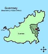
Saint Peter Port is the capital of Guernsey
as well as the main port
. The population in 2001 was 16,488. In Guernésiais and in French, historically the official language of Guernsey, the name of the town and its surrounding parish
is St Pierre Port. The "port" distinguishes this parish from Saint Pierre Du Bois
.
As well as being a parish, St. Peter Port is a small town consisting mostly of steep narrow streets and steps on the overlooking slopes. It is known that a trading post/town has existed here since before Roman times, the pre-Christian name of which has not survived into the modern era.
The post code for addresses in this parish starts with GY1.
People from St. Peter Port, were nicknamed "les Villais" (the townspeople) or "cllichards" in Guernésiais.
. It borders St Sampson's in the North, The Vale
in the North-West, St Andrew's
in the West and St Martin's
in the South.
or the Forest
). This means that there are quite a few cliffs on the coast between Havelet and Fermain.
In addition, the islands of Herm
and Jethou
belong to the parish, but are not part of any canton. They belong to Electoral district Saint Peter Port South.
 The features of the town include:
The following coastal roads (listed from North-South) are also very important as they provide access to the shops, carparks and the harbour
:
Guernsey
Guernsey, officially the Bailiwick of Guernsey is a British Crown dependency in the English Channel off the coast of Normandy.The Bailiwick, as a governing entity, embraces not only all 10 parishes on the Island of Guernsey, but also the islands of Herm, Jethou, Burhou, and Lihou and their islet...
as well as the main port
Port
A port is a location on a coast or shore containing one or more harbors where ships can dock and transfer people or cargo to or from land....
. The population in 2001 was 16,488. In Guernésiais and in French, historically the official language of Guernsey, the name of the town and its surrounding parish
Parish
A parish is a territorial unit historically under the pastoral care and clerical jurisdiction of one parish priest, who might be assisted in his pastoral duties by a curate or curates - also priests but not the parish priest - from a more or less central parish church with its associated organization...
is St Pierre Port. The "port" distinguishes this parish from Saint Pierre Du Bois
St Peter's, Guernsey
St Peter's , known officially as Saint Pierre du Bois is a parish in Guernsey...
.
As well as being a parish, St. Peter Port is a small town consisting mostly of steep narrow streets and steps on the overlooking slopes. It is known that a trading post/town has existed here since before Roman times, the pre-Christian name of which has not survived into the modern era.
The post code for addresses in this parish starts with GY1.
People from St. Peter Port, were nicknamed "les Villais" (the townspeople) or "cllichards" in Guernésiais.
Geography
St. Peter Port is located on the East coast of GuernseyGuernsey
Guernsey, officially the Bailiwick of Guernsey is a British Crown dependency in the English Channel off the coast of Normandy.The Bailiwick, as a governing entity, embraces not only all 10 parishes on the Island of Guernsey, but also the islands of Herm, Jethou, Burhou, and Lihou and their islet...
. It borders St Sampson's in the North, The Vale
Vale, Guernsey
Vale is one of the ten parishes of Guernsey.Until 1806 the parish occupied territory on the mainland of Guernsey, the Vingtaine de l'Epine, as well as the whole of Le Clos du Valle, a tidal island forming the northern extremity of Guernsey separated from the mainland by La Braye du Valle, a tidal...
in the North-West, St Andrew's
St Andrew's, Guernsey
Saint Andrew is located in the centre of Guernsey and as such is the only parish on the island to be landlocked.The post code for addresses in this parish starts with GY6.-Geography:...
in the West and St Martin's
St Martin's, Guernsey
Saint Martin is a parish in Guernsey, English Channel Islands...
in the South.
Relief
The land in the North and by the harbour is low lying but in the South, the land gets much higher (but not as high as St Martin'sSt Martin's, Guernsey
Saint Martin is a parish in Guernsey, English Channel Islands...
or the Forest
Forest, Guernsey
The Forest is a parish in Guernsey. It is the highest parish on the island, with altitudes of up to about 100 m. The full title being Ste Margurite de la Foret after the parish church....
). This means that there are quite a few cliffs on the coast between Havelet and Fermain.
Subdivisions
Saint Peter Port is subdivided into four cantons:- Canton 1 or North Canton
- Canton 2 or Canton of the North-West
- Canton 3 or Canton of the South-West
- Canton 4 or Canton of the South
In addition, the islands of Herm
Herm
Herm is the smallest of the Channel Islands that is open to the public and is part of the Bailiwick of Guernsey. Cars are banned from the small island just like its Channel Island neighbour, Sark. Unlike Sark, bicycles are also banned...
and Jethou
Jethou
Jethou is a small island that is part of the Bailiwick of Guernsey in the Channel Islands. It is privately leased, and not open to the public.It is immediately south of Herm and has an area of approximately .-History:...
belong to the parish, but are not part of any canton. They belong to Electoral district Saint Peter Port South.
Features
- The Royal Court House, seat of the States of GuernseyStates of GuernseyThe States of Guernsey is the parliament of the island of Guernsey. Some laws and ordinances approved by the States of Guernsey also apply to Alderney and Sark as "Bailiwick-wide legislation" with the consent of the governments of those islands...
- Hauteville HouseHauteville HouseHauteville House is a house where Victor Hugo lived during his exile from France, located at 38 Rue Hauteville in St. Peter Port in Guernsey. The house was donated to the City of Paris by Hugo's descendants in March, 1927...
, Victor HugoVictor HugoVictor-Marie Hugo was a Frenchpoet, playwright, novelist, essayist, visual artist, statesman, human rights activist and exponent of the Romantic movement in France....
's house of exile (now a museum run by the city of ParisParisParis is the capital and largest city in France, situated on the river Seine, in northern France, at the heart of the Île-de-France region...
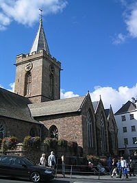
) - The Town Church, the parish church of St Peter Port at the heart of the town
- St Peter Port HarbourSt Peter Port HarbourSaint Peter Port Harbour is located in Saint Peter Port. It was a natural anchorage used by the Romans but it is now Guernsey's main port for passengers. However, a lot of cargo is shipped from St Sampson's harbour. Castle Cornet is on one of the breakwaters....
- Castle CornetCastle CornetCastle Cornet is a large island castle in Guernsey, and former tidal island, also known as Cornet Rock or Castle Rock, which has been part of one of the breakwaters of St Peter Port's harbour, the main one in the island, since 1859.- Geography :...
, the historic fortress that guarded the strategic entrance to the port. The castle was formerly a tidal islandTidal islandA tidal island is a piece of land that is connected to the mainland by a natural or man-made causeway that is exposed at low tide and submerged at high tide. Because of the mystique surrounding tidal islands many of them have been sites of religious worship, such as Mont Saint Michel with its...
that has been joined by a breakwaterBreakwater (structure)Breakwaters are structures constructed on coasts as part of coastal defence or to protect an anchorage from the effects of weather and longshore drift.-Purposes of breakwaters:...
to the enlarged harbourSt Peter Port HarbourSaint Peter Port Harbour is located in Saint Peter Port. It was a natural anchorage used by the Romans but it is now Guernsey's main port for passengers. However, a lot of cargo is shipped from St Sampson's harbour. Castle Cornet is on one of the breakwaters....
since 1859. - Elizabeth CollegeElizabeth College, GuernseyElizabeth College is an independent school in the town of St Peter Port, Guernsey, founded in 1563 under the orders of Queen Elizabeth I.- History :...
founded in 1563 by Elizabeth I of EnglandElizabeth I of EnglandElizabeth I was queen regnant of England and Ireland from 17 November 1558 until her death. Sometimes called The Virgin Queen, Gloriana, or Good Queen Bess, Elizabeth was the fifth and last monarch of the Tudor dynasty...
. The main building (built 1826) is a prominent feature of the skyline. - The market, the Arcade, the High Street and the Pollet, which are all part of the shopping district
- The Guernsey Aquarium, situated in fortified tunnels built by the Nazis during the German Occupation.
- Footes LaneFootes LaneFootes Lane is a multi-use sports stadium in Saint Peter Port, Guernsey. It is the main sports venue in Guernsey. It has a total capacity of 5,000 when hosting all-seated games.- Usage :The stadium is used for a number of sports on the island...
Main roads
The following main roads (listed from North-South) provide important links between St Peter Port and the other parishes:- Les Banques (leads up the coast to St Sampson'sSt Sampson's, GuernseySaint Sampson , is one of the parishes of Guernsey, Channel Islands.The Guernésiais nickname for people from St Sampson is roînes ....
and the North of the Island) - Rue des Varendes (leads to the parish of CastelCastel, GuernseyCastel is the largest Parish in Guernsey in terms of area.It hosts the North Show and Battle of Flowers in August, annually...
) - Mount Row (leads to St Andrew'sSt Andrew's, GuernseySaint Andrew is located in the centre of Guernsey and as such is the only parish on the island to be landlocked.The post code for addresses in this parish starts with GY6.-Geography:...
and the West of the Island) - Ruette Brayes (leads to St Martin'sSt Martin's, GuernseySaint Martin is a parish in Guernsey, English Channel Islands...
and the South of the Island) - Fort Road (leads to St Martin'sSt Martin's, GuernseySaint Martin is a parish in Guernsey, English Channel Islands...
)
The following coastal roads (listed from North-South) are also very important as they provide access to the shops, carparks and the harbour
St Peter Port Harbour
Saint Peter Port Harbour is located in Saint Peter Port. It was a natural anchorage used by the Romans but it is now Guernsey's main port for passengers. However, a lot of cargo is shipped from St Sampson's harbour. Castle Cornet is on one of the breakwaters....
:
- St George's Esplanade
- North Esplanade
- South Esplanade
- Mount Durand