

Southwark St Olave
Encyclopedia
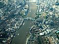
Southwark St Olave was an ancient civil and ecclesiastical parish on the south bank of the River Thames
River Thames
The River Thames flows through southern England. It is the longest river entirely in England and the second longest in the United Kingdom. While it is best known because its lower reaches flow through central London, the river flows alongside several other towns and cities, including Oxford,...
, covering the area around where Shard London Bridge
Shard London Bridge
Shard London Bridge is a skyscraper under construction in Southwark, London. When completed in May 2012, it will be the tallest building in the European Union and the 45th-tallest building in the world, standing tall...
now stands in the modern London Borough of Southwark
London Borough of Southwark
The London Borough of Southwark is a London borough in south east London, England. It is directly south of the River Thames and the City of London, and forms part of Inner London.-History:...
. The boundaries varied over time but in general the parish stretched east from London Bridge
London Bridge
London Bridge is a bridge over the River Thames, connecting the City of London and Southwark, in central London. Situated between Cannon Street Railway Bridge and Tower Bridge, it forms the western end of the Pool of London...
past Tower Bridge
Tower Bridge
Tower Bridge is a combined bascule and suspension bridge in London, England, over the River Thames. It is close to the Tower of London, from which it takes its name...
to St Saviour's Dock
St Saviour's Dock
St Saviour's Dock is a small dock on the south bank of the River Thames, London. It is located approximately 400 metres east of Tower Bridge and forms the eastern boundary of the picturesque and historic area of London known as Shad Thames...
.
Southwark St Olave and St Thomas replaced the civil parish in 1896. It was abolished in 1904 and absorbed by Bermondsey
Bermondsey (parish)
Bermondsey was a parish in the metropolitan area of London, England.The ancient parish was part of Hundred of Brixton and County of Surrey. In 1855 it was included in the area of responsibility of the Metropolitan Board of Works...
parish.
Boundary changes
Southwark St Olave formed part of the ancient Borough of SouthwarkSouthwark
Southwark is a district of south London, England, and the administrative headquarters of the London Borough of Southwark. Situated east of Charing Cross, it forms one of the oldest parts of London and fronts the River Thames to the north...
. Part of its area was split off around 1550 to create Southwark St Thomas, corresponding to the hospital of the Archbishop of Canterbury
Archbishop of Canterbury
The Archbishop of Canterbury is the senior bishop and principal leader of the Church of England, the symbolic head of the worldwide Anglican Communion, and the diocesan bishop of the Diocese of Canterbury. In his role as head of the Anglican Communion, the archbishop leads the third largest group...
. In 1773, part of area was used to create Southwark St John Horsleydown.
Administration
The parish became, with St John Horsleydown and St Thomas, part of the St Olave Poor LawPoor Law
The English Poor Laws were a system of poor relief which existed in England and Wales that developed out of late-medieval and Tudor-era laws before being codified in 1587–98...
Union and in 1855 it became part of the St Olave District
St Olave District (Metropolis)
St Olave was a local government district within the metropolitan area of London, England from 1855 to 1900. It was formed by the Metropolis Management Act 1855 and was governed by the St Olave District Board of Works, which consisted of elected vestrymen....
of the Metropolis. It was absorbed by the County of London
County of London
The County of London was a county of England from 1889 to 1965, corresponding to the area known today as Inner London. It was created as part of the general introduction of elected county government in England, by way of the Local Government Act 1888. The Act created an administrative County of...
in 1889.
In 1896 St Olave was abolished as a civil parish and was combined again with Southwark St Thomas to form Southwark St Olave and St Thomas. In 1900 the combined parish became part of the Metropolitan Borough of Bermondsey
Metropolitan Borough of Bermondsey
The Metropolitan Borough of Bermondsey was a Metropolitan borough in the County of London, created in 1900 by the London Government Act 1899. It was abolished and its area became part of the London Borough of Southwark in 1965.-History:...
and was abolished in 1904, with its former area absorbed into the Bermondsey civil parish, as was that of St John Horsleydown.
The ecclesiastical parish of St Olave was abolished in 1947, and then formed part of Southwark St Olave and St John.
See also
- Tooley StreetTooley StreetTooley Street is a road in South London connecting London Bridge to St Saviour's Dock; it runs past Tower Bridge on the Southwark side of the River Thames, and forms part of the A200 road. - St Olave :...
is the main thoroughfare of the parish and that article covers much of the secular history of the area