
Southern Great Lakes Derecho of 1991
Encyclopedia
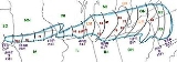
The Southern Great Lakes Derecho of 1991 is the derecho
event that occurred on July 7 and 8, 1991. It lasted 17 hours and raced from South Dakota
through southern Michigan
before dying out over western Pennsylvania
.
 This derecho started in southeastern South Dakota
at around 8 A.M. CDT.
causing more damage. Thousands of acres of corn
and soybean
crops were flattened causing $60 million in damage (1991 dollars).The strongest wind gust -- 103 mph (170 km/h) -- was recorded at Sioux Center, Iowa
. A school's roof was blown off in Orange City
.
A gust of 71 mph was recorded at Mason City
airport. There was also major damage inside the city. A woman was killed in McIntosh Woods State Park when a tree fell on her.
in the early afternoon hours, it died out and a new derecho quickly developed. The derecho quickly gained in size and was once again causing damage. Thirty farm buildings were destroyed and over 250 were damaged over southern Wisconsin. In Waukesha, Wisconsin
, a 300-year old Dunbar Oak tree was toppled. Dane
, Jefferson
, Waukesha
, Washington, and Ozaukee counties were declared Federal Disaster Areas by FEMA.
at around 6:30 P.M. EDT. It would move at up to 60 mph, and knock out power to nearly 853,000 customers. Up to this time this would be the largest number of customers in Michigan to lose power from the same storm system. For some customers it would take up to a week for the power to be restored.
An 84 mph (133 km/h) wind gust was reported at Grand Rapids, Michigan
and at Belding, Michigan
. A semi-trailer was blown over on I-69 near Marshall
.
around 9:30pm EDT. Many electrical lines were blown down and a number of roofs were damaged. A tornado touched down near Stratford
and numerous funnel clouds were reported.
and dissipated over western Pennsylvania
at around 2 A.M. EDT on July 8.
The Southern Great Lakes Derecho of 1991 traveled about 1000 miles (1600 km) in 17 hours, caused $100 million in damage (1991 dollars), cut off electrical power to nearly 1 million customers, killed 1 and injured about 12 others.
Derecho
A derecho is a widespread and long-lived, violent convectively induced straight-line windstorm that is associated with a fast-moving band of severe thunderstorms in the form of a squall line usually taking the form of a bow echo...
event that occurred on July 7 and 8, 1991. It lasted 17 hours and raced from South Dakota
South Dakota
South Dakota is a state located in the Midwestern region of the United States. It is named after the Lakota and Dakota Sioux American Indian tribes. Once a part of Dakota Territory, South Dakota became a state on November 2, 1889. The state has an area of and an estimated population of just over...
through southern Michigan
Michigan
Michigan is a U.S. state located in the Great Lakes Region of the United States of America. The name Michigan is the French form of the Ojibwa word mishigamaa, meaning "large water" or "large lake"....
before dying out over western Pennsylvania
Pennsylvania
The Commonwealth of Pennsylvania is a U.S. state that is located in the Northeastern and Mid-Atlantic regions of the United States. The state borders Delaware and Maryland to the south, West Virginia to the southwest, Ohio to the west, New York and Ontario, Canada, to the north, and New Jersey to...
.
South Dakota
South Dakota
South Dakota is a state located in the Midwestern region of the United States. It is named after the Lakota and Dakota Sioux American Indian tribes. Once a part of Dakota Territory, South Dakota became a state on November 2, 1889. The state has an area of and an estimated population of just over...
at around 8 A.M. CDT.
Iowa
The derecho moved into northern IowaIowa
Iowa is a state located in the Midwestern United States, an area often referred to as the "American Heartland". It derives its name from the Ioway people, one of the many American Indian tribes that occupied the state at the time of European exploration. Iowa was a part of the French colony of New...
causing more damage. Thousands of acres of corn
Maize
Maize known in many English-speaking countries as corn or mielie/mealie, is a grain domesticated by indigenous peoples in Mesoamerica in prehistoric times. The leafy stalk produces ears which contain seeds called kernels. Though technically a grain, maize kernels are used in cooking as a vegetable...
and soybean
Soybean
The soybean or soya bean is a species of legume native to East Asia, widely grown for its edible bean which has numerous uses...
crops were flattened causing $60 million in damage (1991 dollars).The strongest wind gust -- 103 mph (170 km/h) -- was recorded at Sioux Center, Iowa
Sioux Center, Iowa
Sioux Center is a city in Sioux County, Iowa, United States. The population was 6,002 at the 2000 census; a special census in 2005 counted 6,327 residents. The first report of Sioux Center's population from the 2010 census is 7,048...
. A school's roof was blown off in Orange City
Orange City, Iowa
As of the census of 2000, there were 5,582 people, 1,719 households, and 1,285 families residing in the city. The population density was 1,808.5 people per square mile . There were 1,805 housing units at an average density of 584.8 per square mile...
.
A gust of 71 mph was recorded at Mason City
Mason City, Iowa
Mason City is the county seat of Cerro Gordo County, Iowa, United States. The population was 28,079 in the 2010 census, a decline from 29,172 in the 2000 census. The Mason City Micropolitan Statistical Area includes all of Cerro Gordo and Worth counties....
airport. There was also major damage inside the city. A woman was killed in McIntosh Woods State Park when a tree fell on her.
Wisconsin
As this derecho moved into WisconsinWisconsin
Wisconsin is a U.S. state located in the north-central United States and is part of the Midwest. It is bordered by Minnesota to the west, Iowa to the southwest, Illinois to the south, Lake Michigan to the east, Michigan to the northeast, and Lake Superior to the north. Wisconsin's capital is...
in the early afternoon hours, it died out and a new derecho quickly developed. The derecho quickly gained in size and was once again causing damage. Thirty farm buildings were destroyed and over 250 were damaged over southern Wisconsin. In Waukesha, Wisconsin
Waukesha, Wisconsin
Waukesha is a city in and the county seat of Waukesha County, Wisconsin, in the Upper Midwest region of the United States. The population was 70,718 at the 2010 census, making it the largest community in the county and 7th largest in the state. The city is located adjacent to the Town of Waukesha...
, a 300-year old Dunbar Oak tree was toppled. Dane
Dane County, Wisconsin
As of the census of 2000, there were 426,526 people, 173,484 households, and 100,794 families residing in the county. The population density was 355 people per square mile . There were 180,398 housing units at an average density of 150 per square mile...
, Jefferson
Jefferson County, Wisconsin
Jefferson County is a county located in the U.S. state of Wisconsin. As of 2000, the population was 74,021. Its county seat is Jefferson.-Geography:According to the U.S...
, Waukesha
Waukesha County, Wisconsin
Waukesha County is a county in the U.S. state of Wisconsin. As of 2008, the population was 380,629. Its county seat is Waukesha.-History:The part of Wisconsin that Waukesha County now occupies was a part of Michigan when Milwaukee County was organized in September 1834. On July 4, 1836, the...
, Washington, and Ozaukee counties were declared Federal Disaster Areas by FEMA.
Southern Michigan
The derecho entered southern MichiganMichigan
Michigan is a U.S. state located in the Great Lakes Region of the United States of America. The name Michigan is the French form of the Ojibwa word mishigamaa, meaning "large water" or "large lake"....
at around 6:30 P.M. EDT. It would move at up to 60 mph, and knock out power to nearly 853,000 customers. Up to this time this would be the largest number of customers in Michigan to lose power from the same storm system. For some customers it would take up to a week for the power to be restored.
An 84 mph (133 km/h) wind gust was reported at Grand Rapids, Michigan
Grand Rapids, Michigan
Grand Rapids is a city in the U.S. state of Michigan. The city is located on the Grand River about 40 miles east of Lake Michigan. As of the 2010 census, the city population was 188,040. In 2010, the Grand Rapids metropolitan area had a population of 774,160 and a combined statistical area, Grand...
and at Belding, Michigan
Belding, Michigan
Belding is a city in Ionia County in the U.S. state of Michigan. The population was 5,877 at the 2000 census. Belding is a small rural city surrounded almost entirely by farmland...
. A semi-trailer was blown over on I-69 near Marshall
Marshall, Michigan
Marshall is a city located in the U.S. state of Michigan. It is part of the Battle Creek, Michigan Metropolitan Statistical Area. As of the 2000 census, the city population was 7,459. It is the county seat of Calhoun County...
.
Southwestern Ontario
After crossing lower Michigan, the derecho moved into in the Sarnia area of OntarioOntario
Ontario is a province of Canada, located in east-central Canada. It is Canada's most populous province and second largest in total area. It is home to the nation's most populous city, Toronto, and the nation's capital, Ottawa....
around 9:30pm EDT. Many electrical lines were blown down and a number of roofs were damaged. A tornado touched down near Stratford
Stratford, Ontario
Stratford is a city on the Avon River in Perth County in southwestern Ontario, Canada with a population of 32,000.When the area was first settled by Europeans in 1832, the townsite and the river were named after Stratford-upon-Avon, England. It is the seat of Perth County. Stratford was...
and numerous funnel clouds were reported.
Demise
The bow echo system then crossed over Lake ErieLake Erie
Lake Erie is the fourth largest lake of the five Great Lakes in North America, and the tenth largest globally. It is the southernmost, shallowest, and smallest by volume of the Great Lakes and therefore also has the shortest average water residence time. It is bounded on the north by the...
and dissipated over western Pennsylvania
Pennsylvania
The Commonwealth of Pennsylvania is a U.S. state that is located in the Northeastern and Mid-Atlantic regions of the United States. The state borders Delaware and Maryland to the south, West Virginia to the southwest, Ohio to the west, New York and Ontario, Canada, to the north, and New Jersey to...
at around 2 A.M. EDT on July 8.
The Southern Great Lakes Derecho of 1991 traveled about 1000 miles (1600 km) in 17 hours, caused $100 million in damage (1991 dollars), cut off electrical power to nearly 1 million customers, killed 1 and injured about 12 others.
External links
- The Southern Great Lakes Derecho of 1991 (Storm Prediction CenterStorm Prediction CenterThe Storm Prediction Center , located in Norman, Oklahoma, is tasked with forecasting the risk of severe thunderstorms and tornadoes in the contiguous United States. The agency issues convective outlooks, mesoscale discussions, and watches as a part of this process...
)