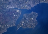
The
Solent is a
straitA strait or straits is a narrow, typically navigable channel of water that connects two larger, navigable bodies of water. It most commonly refers to a channel of water that lies between two land masses, but it may also refer to a navigable channel through a body of water that is otherwise not...
separating the
Isle of WightThe Isle of Wight is a county and the largest island of England, located in the English Channel, on average about 2–4 miles off the south coast of the county of Hampshire, separated from the mainland by a strait called the Solent...
from the mainland of
EnglandThe United Kingdom of Great Britain and Northern IrelandIn the United Kingdom and Dependencies, other languages have been officially recognised as legitimate autochthonous languages under the European Charter for Regional or Minority Languages...
.
The Solent is a major shipping route for passengers, freight and military vessels. It is an important recreational area for water sports, particularly
yachtingYachting refers to recreational sailing or boating, the specific act of sailing or using other water vessels for sporting purposes.-Competitive sailing:...
, hosting the
Cowes WeekCowes Week is one of the longest-running regular regattas in the world. With 40 daily races, up to 1,000 boats, and 8,500 competitors ranging from Olympic and world class professionals to weekend sailors, it is the largest sailing regatta of its kind in the world...
sailing event annually. It is sheltered by the
Isle of WightThe Isle of Wight is a county and the largest island of England, located in the English Channel, on average about 2–4 miles off the south coast of the county of Hampshire, separated from the mainland by a strait called the Solent...
and has a very complex
tidalTides are the rise and fall of sea levels caused by the combined effects of the gravitational forces exerted by the moon and the sun and the rotation of the Earth....
pattern, which has greatly benefited
SouthamptonSouthampton is the largest city in the county of Hampshire on the south coast of England, and is situated south-west of London and north-west of Portsmouth. Southampton is a major port and the closest city to the New Forest...
's success as a
portA port is a location on a coast or shore containing one or more harbors where ships can dock and transfer people or cargo to or from land....
.
PortsmouthPortsmouth is the second largest city in the ceremonial county of Hampshire on the south coast of England. Portsmouth is notable for being the United Kingdom's only island city; it is located mainly on Portsea Island...
lies on its shores.
SpitheadSpithead is an area of the Solent and a roadstead off Gilkicker Point in Hampshire, England. It is protected from all winds, except those from the southeast...
, an area off Gilkicker Point near
GosportGosport is a town, district and borough situated on the south coast of England, within the county of Hampshire. It has approximately 80,000 permanent residents with a further 5,000-10,000 during the summer months...
, is known as the place where the
Royal NavyThe Royal Navy is the naval warfare service branch of the British Armed Forces. Founded in the 16th century, it is the oldest service branch and is known as the Senior Service...
is traditionally reviewed by the monarch of the day.
The area is of great ecological and landscape importance, particularly because of the coastal and estuarine habitats along the edge of the Solent. Much of its coastline is designated as a
Special Area of ConservationA Special Area of Conservation is defined in the European Union's Habitats Directive , also known as the Directive on the Conservation of Natural Habitats and of Wild Fauna and Flora...
. It is bordered by and forms a part of the character of a number of nationally important protected landscapes including the
New ForestThe New Forest is an area of southern England which includes the largest remaining tracts of unenclosed pasture land, heathland and forest in the heavily-populated south east of England. It covers south-west Hampshire and extends into south-east Wiltshire....
National Park, and the
Isle of Wight AONBThe Isle of Wight Area of Outstanding Natural Beauty is an Area of Outstanding Natural Beauty on the Isle of Wight, England's largest offshore island....
.
First recorded in 731 as
Soluente, Solent is "an ancient pre-English name of uncertain origin and meaning."
Prehistory
Originally a river valley, the Solent has gradually widened and deepened for many thousands of years. The
River FromeThe River Frome is a river in Dorset in the south of England. At 30 miles long it is the major chalkstream in southwest England. It is navigable upstream from Poole Harbour as far as the town of Wareham.-Geography:...
was the source of the River Solent, with three other rivers - the Rivers Avon, the
ItchenThe River Itchen is a river in Hampshire, England. It flows from mid-Hampshire to join with Southampton Water below the Itchen Bridge in the city of Southampton. The river has a total length of , and is noted as one of England's - if not one of the World's - premier chalk streams for fly fishing,...
and
TestThe River Test is a river in Hampshire, England. The river has a total length of 40 miles and it flows through downland from its source near Ashe, 10 km to the west of Basingstoke , to the sea at the head of Southampton Water...
being tributaries of it.
http://www.hengistbury-head.co.uk/geology.htmhttp://www.soton.ac.uk/~imw/Solent-Introduction.htm Seismic sounding has shown that when the sea level was lower the River Solent incised its bed to a depth of at least 46 metres = about 151 feet below current
Ordnance DatumIn the British Isles, an Ordnance Datum or OD is a vertical datum used by an ordnance survey as the basis for deriving altitudes on maps. A spot height may be expressed as AOD for "above ordnance datum". Usually mean sea level is used for the datum...
. The
Purbeck Ball ClayPurbeck Ball Clay is a concentration of ball clay found on the Isle of Purbeck in the English county of Dorset.-Geology:The main concentration of ball clay in Dorset is to the north of the Purbeck Hills centred around Norden. Ball clays are sedimentary in origin...
contains
kaoliniteKaolinite is a clay mineral, part of the group of industrial minerals, with the chemical composition Al2Si2O54. It is a layered silicate mineral, with one tetrahedral sheet linked through oxygen atoms to one octahedral sheet of alumina octahedra...
and
micaThe mica group of sheet silicate minerals includes several closely related materials having highly perfect basal cleavage. All are monoclinic, with a tendency towards pseudohexagonal crystals, and are similar in chemical composition...
, showing that in the
LutetianThe Lutetian is, in the geologic timescale, a stage or age in the Eocene. It spans the time between and . The Lutetian is preceded by the Ypresian and is followed by the Bartonian. Together with the Bartonian it is sometimes referred to as the Middle Eocene subepoch...
stage of the
EoceneThe Eocene Epoch, lasting from about 56 to 34 million years ago , is a major division of the geologic timescale and the second epoch of the Paleogene Period in the Cenozoic Era. The Eocene spans the time from the end of the Palaeocene Epoch to the beginning of the Oligocene Epoch. The start of the...
water from a granite area, probably
DartmoorDartmoor is an area of moorland in south Devon, England. Protected by National Park status, it covers .The granite upland dates from the Carboniferous period of geological history. The moorland is capped with many exposed granite hilltops known as tors, providing habitats for Dartmoor wildlife. The...
, flowed into the River Solent.
Seabed survey shows that when the sea level was lower in the
Ice AgeAn ice age or, more precisely, glacial age, is a generic geological period of long-term reduction in the temperature of the Earth's surface and atmosphere, resulting in the presence or expansion of continental ice sheets, polar ice sheets and alpine glaciers...
the River Solent continued the line of the eastern Solent (
SpitheadSpithead is an area of the Solent and a roadstead off Gilkicker Point in Hampshire, England. It is protected from all winds, except those from the southeast...
) to a point roughly due east of the east end of the Isle of Wight and due south of a point about 3 km west of
Selsey BillSelsey Bill is a headland into the English Channel on the south coast of England in the county of West Sussex.The southern most town in Sussex is Selsey which is at the end of the Selsey Peninsula and Selsey Bill is situated on the towns southerncoastline...
, and then south-south-west for about 30 km, and then south for about 14 km, and then joined the main river flowing down the dry bed of the
English ChannelThe English Channel , often referred to simply as the Channel, is an arm of the Atlantic Ocean that separates southern England from northern France, and joins the North Sea to the Atlantic. It is about long and varies in width from at its widest to in the Strait of Dover...
. Since the retreat of the most recent glaciation the South East of England, like the
NetherlandsThe Netherlands is a constituent country of the Kingdom of the Netherlands, located mainly in North-West Europe and with several islands in the Caribbean. Mainland Netherlands borders the North Sea to the north and west, Belgium to the south, and Germany to the east, and shares maritime borders...
, has been steadily slowly sinking through historic time due to
forebulgeIn geology, a forebulge is a flexural bulge in front of a load on the lithosphere. This load causes the lithosphere to flex by depressing the plate beneath it. Because of the flexural rigidity of the lithosphere, the area around the load is uplifted by a height that is 4% of that of the depression...
sinking.
A new theory - that the Solent was originally a lagoon - was reported in the
Southern Daily Echo by Garry Momber from the Hampshire and Wight Trust for Maritime Archaeology.
The Isle of Wight was formerly contiguous with the
Isle of PurbeckThe Isle of Purbeck, not a true island but a peninsula, is in the county of Dorset, England. It is bordered by the English Channel to the south and east, where steep cliffs fall to the sea; and by the marshy lands of the River Frome and Poole Harbour to the north. Its western boundary is less well...
in Dorset - the Needles are the last remnant of this connection.
Human history
Remains of human habitation have been found from the prehistoric,
RomanRoman Britain was the part of the island of Great Britain controlled by the Roman Empire from AD 43 until ca. AD 410.The Romans referred to the imperial province as Britannia, which eventually comprised all of the island of Great Britain south of the fluid frontier with Caledonia...
and
SaxonAnglo-Saxon is a term used by historians to designate the Germanic tribes who invaded and settled the south and east of Great Britain beginning in the early 5th century AD, and the period from their creation of the English nation to the Norman conquest. The Anglo-Saxon Era denotes the period of...
eras, showing that humans retreated towards progressively higher ground over these periods. Offshore from Bouldnor, Isle of Wight, divers have found at 11 metres depth the submerged remains of a wooden building that was built there on land around 6000 BC when the sea level was lower and the land was higher.
There is an early
NormanNorman dynasty is the usual designation for the family that were the Dukes of Normandy and the English monarchs which immediately followed the Norman conquest and lasted until the Plantagenet dynasty came to power in 1154. It included Rollo and his descendants, and from William the Conqueror and...
period report that much land on the south of
Hayling Island-Leisure activities:Although largely residential, Hayling is also a holiday, windsurfing and sailing centre, the site where windsurfing was invented....
was lost to sea flood. South of
Hayling Island-Leisure activities:Although largely residential, Hayling is also a holiday, windsurfing and sailing centre, the site where windsurfing was invented....
in the Solent is a deposit of stones, which scuba divers found to be the remains of a stone building, probably a church. There is an old report that this church was formerly in the middle of Hayling Island. If similar amounts of land have been lost on other parts of the Solent shore, the Solent was likely much narrower in
RomanAncient Rome was a thriving civilization that grew on the Italian Peninsula as early as the 8th century BC. Located along the Mediterranean Sea and centered on the city of Rome, it expanded to one of the largest empires in the ancient world....
times, and it is possible to believe a Roman author's report that in his time men could wade to the Isle of Wight at low tide. Similarly, it is known that
SelseySelsey is a seaside town and civil parish, about seven miles south of Chichester, in the Chichester District of West Sussex, England. Selsey lies at the southernmost point of the Manhood Peninsula, almost cut off from mainland Sussex by the sea...
was once a port town, with
Selsey AbbeySelsey Abbey was almost certainly built at Church Norton, Selsey, Sussex, England. It was founded in 683AD, and became the seat of the Sussex bishopric, until it was moved in 1075AD to Chichester.-Historical Context :...
and a
cathedraA cathedra or bishop's throne is the chair or throne of a bishop. It is a symbol of the bishop's teaching authority in the Catholic Church and the Orthodox Church, and has in some sense remained such in the Anglican Communion and in Lutheran churches...
recorded until 1075, when the see of the
Diocese of SussexThe Diocese of Chichester is a Church of England diocese based in Chichester, covering Sussex. It was created in 1075 to replace the old Diocese of Selsey, which was based at Selsey Abbey from 681. The cathedral is Chichester Cathedral and the bishop is the Bishop of Chichester...
was moved inland to
ChichesterChichester is a cathedral city in West Sussex, within the historic County of Sussex, South-East England. It has a long history as a settlement; its Roman past and its subsequent importance in Anglo-Saxon times are only its beginnings...
.
During the late
Middle AgesThe Middle Ages is a periodization of European history from the 5th century to the 15th century. The Middle Ages follows the fall of the Western Roman Empire in 476 and precedes the Early Modern Era. It is the middle period of a three-period division of Western history: Classic, Medieval and Modern...
,
Henry VIII of EnglandHenry VIII was King of England from 21 April 1509 until his death. He was Lord, and later King, of Ireland, as well as continuing the nominal claim by the English monarchs to the Kingdom of France...
built an extensive set of
coastal defenceCoastal defence , Coastal defense and Coastal fortification are measures taken to provide protection against attack by military and naval forces at or near the shoreline...
s at each end of the Solent, part of his
Device FortsThe Device Forts, also known as Henrician Castles, are a series of artillery fortifications built to defend the southern coast of England by Henry VIII. After his divorce of Catherine of Aragon England was left politically isolated, and the peace of Nice between France and Spain in 1538 aroused...
, effectively controlling access to east and west. More forts were built on land and at sea in the 19th century. These were generally known as
Palmerston FortsThe Palmerston Forts that encircle Portsmouth were built in response to the 1859 Royal Commission dealing with the perceived threat of a French invasion. The forts were intended to defend the Dockyard in Portsmouth. Construction was carried out by the Royal Engineers and civilian contractors...
In 1685 King
James IIJames II & VII was King of England and King of Ireland as James II and King of Scotland as James VII, from 6 February 1685. He was the last Catholic monarch to reign over the Kingdoms of England, Scotland, and Ireland...
narrowly escaped shipwreck while sailing in the Solent. Musician
Henry PurcellHenry Purcell – 21 November 1695), was an English organist and Baroque composer of secular and sacred music. Although Purcell incorporated Italian and French stylistic elements into his compositions, his legacy was a uniquely English form of Baroque music...
wrote "They that go down to the sea in ships" to be sung by extraordinary voice of
John GostlingJohn Gostling was a 17th century Church of England clergyman and bass singer famed for his range and power. He was a favourite singer of Charles II and is particularly associated with the music of Henry Purcell.-Background:...
to commemorate it.
The Solent was one of two sites for the
sailingSailing/Yachting is a Olympic sport starting from the Games of the 1st Olympiad . With the exception of 1904 and possible 1916 sailing was always a part of the Olympic program....
events at the
1908 Summer OlympicsThe 1908 Summer Olympics, officially the Games of the IV Olympiad, were an international multi-sport event which was held in 1908 in London, England, United Kingdom. These games were originally scheduled to be held in Rome. At the time they were the fifth modern Olympic games...
.
The Solent became the departure area of the ill-fated ocean liner,
Titanic, in April 1912.
In 1982 Henry VIII's flagship, the
Mary RoseThe Mary Rose was a carrack-type warship of the English Tudor navy of King Henry VIII. After serving for 33 years in several wars against France, Scotland, and Brittany and after being substantially rebuilt in 1536, she saw her last action on 1545. While leading the attack on the galleys of a...
, was lifted off the seabed of the Solent, 437 years after it sank.
A bank in the centre of the Solent,
Bramble BankThe Bramble Bank, otherwise known simply as "The Brambles" is an arrowhead-shaped sandbar in the central Solent which is uncovered at low water spring tides. At other times it presents either a significant navigational hazard or a useful escape from the strong Solent tides. The bank is moving very...
, is exposed at
low water at spring tideTides are the rise and fall of sea levels caused by the combined effects of the gravitational forces exerted by the moon and the sun and the rotation of the Earth....
. This, combined with the unique tidal patterns in the area, makes navigation challenging. There is an annual
cricketCricket is a bat-and-ball game played between two teams of 11 players on an oval-shaped field, at the centre of which is a rectangular 22-yard long pitch. One team bats, trying to score as many runs as possible while the other team bowls and fields, trying to dismiss the batsmen and thus limit the...
match on Bramble Bank during the lowest tide of the year, but games are often cut short by rising tide.
Geology
Ten thousand years ago a band of relatively resistant
ChalkChalk is a soft, white, porous sedimentary rock, a form of limestone composed of the mineral calcite. Calcite is calcium carbonate or CaCO3. It forms under reasonably deep marine conditions from the gradual accumulation of minute calcite plates shed from micro-organisms called coccolithophores....
rock, part of the
Southern England Chalk FormationThe Chalk Formation of Southern England is a system of chalk downland in the south of England. The formation is perhaps best known for Salisbury Plain, the location of Stonehenge, the Isle of Wight and the twin ridgeways of the North Downs and South Downs....
ran from the
Isle of PurbeckThe Isle of Purbeck, not a true island but a peninsula, is in the county of Dorset, England. It is bordered by the English Channel to the south and east, where steep cliffs fall to the sea; and by the marshy lands of the River Frome and Poole Harbour to the north. Its western boundary is less well...
area of south
DorsetDorset , is a county in South West England on the English Channel coast. The county town is Dorchester which is situated in the south. The Hampshire towns of Bournemouth and Christchurch joined the county with the reorganisation of local government in 1974...
to the eastern end of
Isle of WightThe Isle of Wight is a county and the largest island of England, located in the English Channel, on average about 2–4 miles off the south coast of the county of Hampshire, separated from the mainland by a strait called the Solent...
, parallel to the
South DownsThe South Downs is a range of chalk hills that extends for about across the south-eastern coastal counties of England from the Itchen Valley of Hampshire in the west to Beachy Head, near Eastbourne, East Sussex, in the east. It is bounded on its northern side by a steep escarpment, from whose...
. Inland behind the Chalk were less resistant sands, clays and gravels. Through these weak soils and rocks ran many rivers, from the
Dorset FromeThe River Frome is a river in Dorset in the south of England. At 30 miles long it is the major chalkstream in southwest England. It is navigable upstream from Poole Harbour as far as the town of Wareham.-Geography:...
in the west and including the
StourThe River Stour is a 60.5 mile long river which flows through Wiltshire and Dorset in southern England, and drains into the English Channel. It is sometimes called the Dorset Stour to distinguish it from rivers of the same name...
,
Beaulieu RiverThe Beaulieu River , formerly known as the River Exe, is a small river flowing south through the New Forest in the county of Hampshire in southern England. The river is some long, of which the last are tidal...
,
TestThe River Test is a river in Hampshire, England. The river has a total length of 40 miles and it flows through downland from its source near Ashe, 10 km to the west of Basingstoke , to the sea at the head of Southampton Water...
,
ItchenThe River Itchen is a river in Hampshire, England. It flows from mid-Hampshire to join with Southampton Water below the Itchen Bridge in the city of Southampton. The river has a total length of , and is noted as one of England's - if not one of the World's - premier chalk streams for fly fishing,...
and
HambleThe River Hamble is a river in Hampshire, England. It rises near Bishop's Waltham and flows for some 7.5 miles through Botley, Bursledon and Swanwick before entering Southampton Water near Hamble-le-Rice and Warsash....
, which created a large
estuaryAn estuary is a partly enclosed coastal body of water with one or more rivers or streams flowing into it, and with a free connection to the open sea....
flowing west to east and into the English Channel at the eastern end of the present Solent. This great estuary ran through a wooded valley and is now referred to as the Solent River.
When
glacierA glacier is a large persistent body of ice that forms where the accumulation of snow exceeds its ablation over many years, often centuries. At least 0.1 km² in area and 50 m thick, but often much larger, a glacier slowly deforms and flows due to stresses induced by its weight...
s covering the north of Britain melted at the end of the last
ice ageAn ice age or, more precisely, glacial age, is a generic geological period of long-term reduction in the temperature of the Earth's surface and atmosphere, resulting in the presence or expansion of continental ice sheets, polar ice sheets and alpine glaciers...
, two things happened to create the Solent. Firstly, a great amount of flood water ran into the Solent River and its tributaries, carving the estuary deeper. Secondly,
post-glacial reboundPost-glacial rebound is the rise of land masses that were depressed by the huge weight of ice sheets during the last glacial period, through a process known as isostasy...
after the removal of the weight of ice over
ScotlandScotland is a country that is part of the United Kingdom. Occupying the northern third of the island of Great Britain, it shares a border with England to the south and is bounded by the North Sea to the east, the Atlantic Ocean to the north and west, and the North Channel and Irish Sea to the...
caused the island of
Great BritainGreat Britain or Britain is an island situated to the northwest of Continental Europe. It is the ninth largest island in the world, and the largest European island, as well as the largest of the British Isles...
to tilt about an east-west axis, because isostatic rebound in
ScotlandScotland is a country that is part of the United Kingdom. Occupying the northern third of the island of Great Britain, it shares a border with England to the south and is bounded by the North Sea to the east, the Atlantic Ocean to the north and west, and the North Channel and Irish Sea to the...
and
ScandinaviaScandinavia is a cultural, historical and ethno-linguistic region in northern Europe that includes the three kingdoms of Denmark, Norway and Sweden, characterized by their common ethno-cultural heritage and language. Modern Norway and Sweden proper are situated on the Scandinavian Peninsula,...
is pulling
mantleThe mantle is a part of a terrestrial planet or other rocky body large enough to have differentiation by density. The interior of the Earth, similar to the other terrestrial planets, is chemically divided into layers. The mantle is a highly viscous layer between the crust and the outer core....
rock out from under the
NetherlandsThe Netherlands is a constituent country of the Kingdom of the Netherlands, located mainly in North-West Europe and with several islands in the Caribbean. Mainland Netherlands borders the North Sea to the north and west, Belgium to the south, and Germany to the east, and shares maritime borders...
and south
EnglandEngland is a country that is part of the United Kingdom. It shares land borders with Scotland to the north and Wales to the west; the Irish Sea is to the north west, the Celtic Sea to the south west, with the North Sea to the east and the English Channel to the south separating it from continental...
: this is
forebulgeIn geology, a forebulge is a flexural bulge in front of a load on the lithosphere. This load causes the lithosphere to flex by depressing the plate beneath it. Because of the flexural rigidity of the lithosphere, the area around the load is uplifted by a height that is 4% of that of the depression...
sinking. Over thousands of years, the land sank in the south (a process still continuing) to submerge many valleys creating today's characteristic
riaA ria is a coastal inlet formed by the partial submergence of an unglaciated river valley. It is a drowned river valley that remains open to the sea. Typically, rias have a dendritic, treelike outline although they can be straight and without significant branches. This pattern is inherited from the...
s, such as
Southampton WaterSouthampton Water is a tidal estuary north of the Solent and the Isle of Wight in England. The city of Southampton lies at its most northerly point. Along its salt marsh-fringed western shores lie the New Forest villages of Hythe and "the waterside", Dibden Bay, and the Esso oil refinery at Fawley...
and
Poole HarbourPoole Harbour is a large natural harbour in Dorset, southern England, with the town of Poole on its shores. The harbour is a drowned valley formed at the end of the last ice age and is the estuary of several rivers, the largest being the Frome. The harbour has a long history of human settlement...
, as well as submerging the Solent. The estuary of the Solent River was gradually flooded, and eventually the
Isle of WightThe Isle of Wight is a county and the largest island of England, located in the English Channel, on average about 2–4 miles off the south coast of the county of Hampshire, separated from the mainland by a strait called the Solent...
became separated from the mainland as the
chalkChalk is a soft, white, porous sedimentary rock, a form of limestone composed of the mineral calcite. Calcite is calcium carbonate or CaCO3. It forms under reasonably deep marine conditions from the gradual accumulation of minute calcite plates shed from micro-organisms called coccolithophores....
ridge between
The NeedlesThe Needles is a row of three distinctive stacks of chalk that rise out of the sea off the western extremity of the Isle of Wight, England, close to Alum Bay. The Needles lighthouse stands at the end of the formation...
on the island and
Old Harry RocksThe Old Harry Rocks are two chalk sea stacks located at Handfast Point, on the Isle of Purbeck in Dorset, southern England.- Location :Old Harry Rocks lie directly east of Studland, about 4 kilometres northeast of Swanage, and about 10 kilometres south of the large towns of Poole and...
on the mainland was eroded. This is thought to have happened about 7,000 years ago.
The process of coastal change is still continuing, with the soft cliffs on some parts of the Solent, such as
Fort VictoriaFort Victoria was a single tier battery with defensible barracks west of Yarmouth, Isle of Wight, England, built in the 1850s, later used as a submarine mining centre and training area for military purposes....
, constantly eroding, whilst other parts, such as Ryde Sands, accreting.
The Solent is a comparatively shallow stretch of tidal water. It has an unusual double tide that is both favourable to maritime activities as well as a hazard with its strong tidal movements and quickly changing sea states.
Coupled with the above, the Solent is renowned for its large volume of vessel usage, thus resulting in one of the highest density of declared lifeboat stations in the world. This includes six RNLI (e.g.
CalshotCalshot is a coastal village in Hampshire, England at the west corner of Southampton_Water where it joins the Solent. A settlement at the site is believed to have existed since the fifth century AD...
and
CowesCowes is an English seaport town and civil parish on the Isle of Wight. Cowes is located on the west bank of the estuary of the River Medina facing the smaller town of East Cowes on the east Bank...
) and five independently run stations (e.g.
HambleHamble may refer to:* The last frontier film location.* The River Hamble in Hampshire, England**Hamble-Warsash Ferry, a ferry service on the River Hamble* Hamble-le-Rice, a village on the river Hamble, close to the city of Southampton, England...
Lifeboat and
GosportGosport is a town, district and borough situated on the south coast of England, within the county of Hampshire. It has approximately 80,000 permanent residents with a further 5,000-10,000 during the summer months...
and
FarehamThe market town of Fareham lies in the south east of Hampshire, England, between the cities of Southampton and Portsmouth, roughly in the centre of the South Hampshire conurbation.It gives its name to the borough comprising the town and the surrounding area...
Inshore Rescue).
See also
- Southampton Water
Southampton Water is a tidal estuary north of the Solent and the Isle of Wight in England. The city of Southampton lies at its most northerly point. Along its salt marsh-fringed western shores lie the New Forest villages of Hythe and "the waterside", Dibden Bay, and the Esso oil refinery at Fawley...
- Portsmouth Harbour
Portsmouth Harbour is a large natural harbour in Hampshire, England. Geographically it is a ria: formerly it was the valley of a stream flowing from Portsdown into the Solent River. The city of Portsmouth lies to the east on Portsea Island, and Gosport to the west on the mainland...
- Ports and harbours of the Solent
External links