
South Carolina Highway 90
Encyclopedia
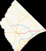
South Carolina Highway 90 (abbreviated S.C. Highway 90 or SC 90) is a two-lane highway from in Horry County going from Red Hill
(near Conway
) to Little River
. It provides a direct connection from Conway to the North Strand in Little River
.
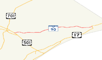 South Carolina Highway 90 begins and ends from US 17
/SC 9 Concurrent
at N. Myrtle Beach
from the bridge
across the Intracoastal Waterway
to US 501 Bus.
near Red Hill
and it directs Eastbound and Westbound with a "T" road on Robert Edge Parkway and Wampee Road near Wampee
and no interchange on SC 31, SC 90 is in the completed Horry County
.
will construct and widen South Carolina 90 into a 4-lane multilane roadway/Divided highway
with a Cement Median
and without the grass it will have road sign
s and sign holder
s with light fixtures, mileage signs, metal poles, Street light
s, traffic light
s, side road, T Road, Divided highway ends, signal ahead signs and so many more of them, the Old Reaves Ferry Road connects to SC 905
and it is not intersected with it. The interchange of US 17
/SC 9 Concurrent
would have the Trumpet Interchange
before and after the bridge
across the Intracoastal Waterway
from Little River
to N. Myrtle Beach
.
Red Hill, South Carolina
Red Hill is a census-designated place in Horry County, South Carolina, United States. The population was 10,509 at the 2000 census.-Geography:Red Hill is located at ....
(near Conway
Conway, South Carolina
Conway is a city in Horry County, South Carolina, United States. The population was 16,317 at the 2010 census. It is the county seat of Horry County and is part of the Myrtle Beach metropolitan area. It is the home of Coastal Carolina University....
) to Little River
Little River, South Carolina
Little River is a census-designated place in Horry County, South Carolina, United States. The population was 7,027 at the 2000 census....
. It provides a direct connection from Conway to the North Strand in Little River
Little River, South Carolina
Little River is a census-designated place in Horry County, South Carolina, United States. The population was 7,027 at the 2000 census....
.
Route description
U.S. Route 17 in South Carolina
In the U.S. state of South Carolina, U.S. Route 17 is a north–south highway located near the Atlantic Ocean. The route enters the state from Georgia at the Savannah River and serves Charleston and Myrtle Beach before entering North Carolina near Calabash.-Route description:US 17 enters into...
/SC 9 Concurrent
Concurrency (road)
A concurrency, overlap, or coincidence in a road network is an instance of one physical road bearing two or more different highway, motorway, or other route numbers...
at N. Myrtle Beach
North Myrtle Beach, South Carolina
North Myrtle Beach is a coastal resort city in Horry County, South Carolina, United States. It was created in 1968 from four existing municipalities north of Myrtle Beach, and serves as one of the primary tourist towns along the Grand Strand...
from the bridge
Bridge
A bridge is a structure built to span physical obstacles such as a body of water, valley, or road, for the purpose of providing passage over the obstacle...
across the Intracoastal Waterway
Intracoastal Waterway
The Intracoastal Waterway is a 3,000-mile waterway along the Atlantic and Gulf coasts of the United States. Some lengths consist of natural inlets, salt-water rivers, bays, and sounds; others are artificial canals...
to US 501 Bus.
U.S. Route 501
-North Carolina business loops:-Virginia business loop:-External links:*...
near Red Hill
Red Hill, South Carolina
Red Hill is a census-designated place in Horry County, South Carolina, United States. The population was 10,509 at the 2000 census.-Geography:Red Hill is located at ....
and it directs Eastbound and Westbound with a "T" road on Robert Edge Parkway and Wampee Road near Wampee
Wampee, South Carolina
Wampee is an unincorporated community in Horry County, South Carolina, United States, along South Carolina Highway 90. Wampee is located near North Myrtle Beach across from the Intracoastal Waterway. Robert Edge Parkway starts here....
and no interchange on SC 31, SC 90 is in the completed Horry County
Horry County, South Carolina
Horry County is a county located in the U.S. state of South Carolina. This name honored Revolutionary War Hero, Peter Horry. Brigadier General Horry was born in South Carolina sometime around 1743 and started his distinguished military career in 1775 as one of 20 captains the Provincial Congress...
.
History
In some times SCDOTSouth Carolina Department of Transportation
The South Carolina Department of Transportation is a government agency in the US state of South Carolina. Its mission is to build and maintain roads and bridges and administer mass transit services....
will construct and widen South Carolina 90 into a 4-lane multilane roadway/Divided highway
Dual carriageway
A dual carriageway is a class of highway with two carriageways for traffic travelling in opposite directions separated by a central reservation...
with a Cement Median
Central reservation
On divided roads, such as divided highways or freeways/motorways, the central reservation , median, parkway , median strip or central nature strip is the area which separates opposing lanes of traffic...
and without the grass it will have road sign
Traffic sign
Traffic signs or road signs are signs erected at the side of roads to provide information to road users. With traffic volumes increasing over the last eight decades, many countries have adopted pictorial signs or otherwise simplified and standardized their signs to facilitate international travel...
s and sign holder
Gantry (road sign)
A gantry is a traffic sign assembly in which signs are mounted on an overhead support, or railway signals supported....
s with light fixtures, mileage signs, metal poles, Street light
Street light
A street light, lamppost, street lamp, light standard, or lamp standard is a raised source of light on the edge of a road or walkway, which is turned on or lit at a certain time every night. Modern lamps may also have light-sensitive photocells to turn them on at dusk, off at dawn, or activate...
s, traffic light
Traffic light
Traffic lights, which may also be known as stoplights, traffic lamps, traffic signals, signal lights, robots or semaphore, are signalling devices positioned at road intersections, pedestrian crossings and other locations to control competing flows of traffic...
s, side road, T Road, Divided highway ends, signal ahead signs and so many more of them, the Old Reaves Ferry Road connects to SC 905
South Carolina Highway 905
South Carolina Highway 905 is a state highway in Horry County. It starts from Conway to the South Carolina state line continuing on to North Carolina Highway 905. It is parallel to the Waccamaw River.-Major intersections:...
and it is not intersected with it. The interchange of US 17
U.S. Route 17 in South Carolina
In the U.S. state of South Carolina, U.S. Route 17 is a north–south highway located near the Atlantic Ocean. The route enters the state from Georgia at the Savannah River and serves Charleston and Myrtle Beach before entering North Carolina near Calabash.-Route description:US 17 enters into...
/SC 9 Concurrent
Concurrency (road)
A concurrency, overlap, or coincidence in a road network is an instance of one physical road bearing two or more different highway, motorway, or other route numbers...
would have the Trumpet Interchange
Interchange (road)
In the field of road transport, an interchange is a road junction that typically uses grade separation, and one or more ramps, to permit traffic on at least one highway to pass through the junction without directly crossing any other traffic stream. It differs from a standard intersection, at which...
before and after the bridge
Bridge
A bridge is a structure built to span physical obstacles such as a body of water, valley, or road, for the purpose of providing passage over the obstacle...
across the Intracoastal Waterway
Intracoastal Waterway
The Intracoastal Waterway is a 3,000-mile waterway along the Atlantic and Gulf coasts of the United States. Some lengths consist of natural inlets, salt-water rivers, bays, and sounds; others are artificial canals...
from Little River
Little River, South Carolina
Little River is a census-designated place in Horry County, South Carolina, United States. The population was 7,027 at the 2000 census....
to N. Myrtle Beach
North Myrtle Beach, South Carolina
North Myrtle Beach is a coastal resort city in Horry County, South Carolina, United States. It was created in 1968 from four existing municipalities north of Myrtle Beach, and serves as one of the primary tourist towns along the Grand Strand...
.
Major intersections
The entire route is in the unincorporated Horry CountyHorry County, South Carolina
Horry County is a county located in the U.S. state of South Carolina. This name honored Revolutionary War Hero, Peter Horry. Brigadier General Horry was born in South Carolina sometime around 1743 and started his distinguished military career in 1775 as one of 20 captains the Provincial Congress...
| Location | Mile | Junction | Notes |
|---|---|---|---|
| Red Hill Red Hill, South Carolina Red Hill is a census-designated place in Horry County, South Carolina, United States. The population was 10,509 at the 2000 census.-Geography:Red Hill is located at .... |
0.0 | Western terminus | |
| 1.2 | French Collins Road | ||
| 2.5 | East Cox Ferry Road | ||
| 3.8 | Lees Landing Circle | ||
| Nixonville | 6.8 | International Drive | Connects to Grissom Parkway Robert Grissom Parkway Robert M. Grissom Parkway, locally known as Grissom Parkway, is a major four-lane connector highway in Myrtle Beach, South Carolina. The road begins at Harrelson Boulevard near Myrtle Beach International Airport and terminates in Carolina Forest, South Carolina at SC Highway 31 and International... |
| 10.0 | Old Reaves Ferry Road | Connects to | |
| Wampee Wampee, South Carolina Wampee is an unincorporated community in Horry County, South Carolina, United States, along South Carolina Highway 90. Wampee is located near North Myrtle Beach across from the Intracoastal Waterway. Robert Edge Parkway starts here.... |
12.5 | Full interchange | |
| 17.8 | Wampee Road North – Stephens Crossroads | ||
| 19.4 | Robert Edge Parkway West – DOWNTOWN N. Myrtle Beach North Myrtle Beach, South Carolina North Myrtle Beach is a coastal resort city in Horry County, South Carolina, United States. It was created in 1968 from four existing municipalities north of Myrtle Beach, and serves as one of the primary tourist towns along the Grand Strand... |
Connects to and Main Street. | |
| Little River Little River, South Carolina Little River is a census-designated place in Horry County, South Carolina, United States. The population was 7,027 at the 2000 census.... |
22.0 | Sea Mountain Highway | |
| 23.1 | Eastern terminus |