

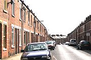
South Bank, York
Encyclopedia
River Ouse, Yorkshire
The River Ouse is a river in North Yorkshire, England. The river is formed from the River Ure at Cuddy Shaw Reach near Linton-on-Ouse, about 6 miles downstream of the confluence of the River Swale with the River Ure...
in York
York
York is a walled city, situated at the confluence of the Rivers Ouse and Foss in North Yorkshire, England. The city has a rich heritage and has provided the backdrop to major political events throughout much of its two millennia of existence...
. The area is dominated by the disused Terry's
Terry's
Terry's was a chocolate and confectionery maker in York, England. Its history stretched back to 1823, but in 1993 it was taken over by Kraft Foods. The York factory closed in 2005 and Terry's products are now produced in other Kraft facilities in Poland, Sweden, Belgium, and...
chocolate factory and the numerous streets of terraced housing that surround it. Terry's Chocolate Factory opened in 1926, where over the years it manufactured Terry's Chocolate Orange, Terry's All Gold and York Fruits. Terry's was acquired by Kraft Foods
Kraft Foods
Kraft Foods Inc. is an American confectionery, food and beverage conglomerate. It markets many brands in more than 170 countries. 12 of its brands annually earn more than $1 billion worldwide: Cadbury, Jacobs, Kraft, LU, Maxwell House, Milka, Nabisco, Oscar Mayer, Philadelphia, Trident, Tang...
in 1993, and the factory was finally closed in 2003 when production moved to various plants across Europe.
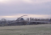
Near the factory is located York Racecourse
York Racecourse
York Racecourse is a horse racing track in the southwest of the city of York in North Yorkshire, England with a spectator capacity of 60,000. The most famous race to be held at York on an annual basis is the Ebor Handicap, which is run during the Ebor Festival meeting in August...
, which forms part of the larger Knavesmire
Knavesmire
The Knavesmire is one of a number of large, marshy undeveloped areas within the city of York in North Yorkshire, England which are collectively known as Strays...
. There is an Athletics Club, the Knavesmire Harriers, who train in this area. South Bank is also the location of Rowntree Park
Rowntree Park
Rowntree Park is a park in York, England open to the public, featuring children's playgrounds, tennis courts, bowling greens, basketball court, skateboarding area and general areas for picnicking...
near to the river. The Millennium Bridge is a footbridge built in 2001 that links South Bank to Fishergate
Fishergate
Fishergate is one of the centre wards of York, England. It is situated directly south of the city walls, on the east bank of the River Ouse, north of Fulford. On its north west corner is the confluence point of the Foss and the Ouse. This area is protected from floods by the Foss Barrier...
and Fulford
Fulford
Fulford is a historic village and civil parish on the outskirts of York, England. Situated to the south of the city, on the east bank of the River Ouse, it was the site of the 11th century Battle of Fulford...
on the other side of the river.
Knavesmire Primary School opened in 1914 and is the main primary school in the area. Millthorpe School
Millthorpe School
-Admissions:It comprises five blocks lettered A-E, and has over 1,100 pupils and 200 staff. It teaches a wide range of subjects from information technology to manufacturing....
is a specialist language college and has recently been awarded specialist status in science. The York branch of the College of Law is located on Bishopthorpe Road. Many law students rent houses in South Bank.
St Chad's Greys is the local Scout
The Scout Association
The Scout Association is the World Organization of the Scout Movement recognised Scouting association in the United Kingdom. Scouting began in 1907 through the efforts of Robert Baden-Powell. The Scout Association was formed under its previous name, The Boy Scout Association, in 1910 by the grant...
Group. It was formed in 1926 and is one of the largest groups in York and one of only three groups in North Yorkshire which have a Scout Band.
Location
(All walk times calculated by GPS from South Bank Avenue)- 20 minutes' walk or 5 minutes by bicycle to York railway stationYork railway stationYork railway station is a main-line railway station in the city of York, England. It lies on the East Coast Main Line north of London's King's Cross station towards Edinburgh's Waverley Station...
- 18 minutes' walk or 4 minutes by bicycle to York City Centre
- 14 minutes' walk or 3 minutes by bicycle to the York greenbeltGreen Belt (UK)In United Kingdom town planning, the green belt is a policy for controlling urban growth. The idea is for a ring of countryside where urbanisation will be resisted for the foreseeable future, maintaining an area where agriculture, forestry and outdoor leisure can be expected to prevail...
along the River OuseRiver Ouse, YorkshireThe River Ouse is a river in North Yorkshire, England. The river is formed from the River Ure at Cuddy Shaw Reach near Linton-on-Ouse, about 6 miles downstream of the confluence of the River Swale with the River Ure... - 7 minutes' walk or 1 minute by bicycle to York Racecourse
- The York to Selby cycle path (Distance: 15 miles one way) starts from near York Racecourse.
- 6 minutes' walk or 1 minute by bicycle to the proposed luxury development at the old Terry's Chocolate Factory