
Sonoma Mountains
Encyclopedia
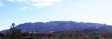
The Sonoma Mountains are a northwest-southeast trending formation of California Coast Ranges in Sonoma County, California
, USA. The range is approximately fourteen miles (22.5 km) long and separates the Sonoma Creek
watershed
from the Petaluma River
and Tolay Creek
watersheds. The highest point of this range is Sonoma Mountain
, elevation 2287 ft (697 m).
Jack London State Historic Park
, Crane Creek Regional Park
, and the Fairfield Osborn Preserve
are all on Sonoma Mountain. A number of threatened and endangered species
are found in the Sonoma Mountains including the Fragrant Fritillary, Fritillaria liliacea.
and Hinebaugh Creek
flow to the Laguna de Santa Rosa
, eventually entering the Pacific Ocean
just south of Jenner, California
. Matanzas Creek
and Spring Creek flow north into Santa Rosa Creek
, another tributary of the Laguna.
Tributaries of Sonoma Creek
rise on the eastern exposures of the Sonoma Mountains: Yulupa Creek
, Carriger Creek, Graham Creek
, Felder Creek, and Rogers Creek. These eventually enter San Pablo Bay
south of Sonoma, California
.
The southwestern slopes drain to San Pablo Bay
by other routes: either Tolay Creek
or else some tributary of the Petaluma River
such as Lichau Creek
, Lynch Creek
, or Adobe Creek
.
Sonoma County, California
Sonoma County, located on the northern coast of the U.S. state of California, is the largest and northernmost of the nine San Francisco Bay Area counties. Its population at the 2010 census was 483,878. Its largest city and county seat is Santa Rosa....
, USA. The range is approximately fourteen miles (22.5 km) long and separates the Sonoma Creek
Sonoma Creek
Sonoma Creek is a stream in northern California. It is one of two principal drainages of southern Sonoma County, California, with headwaters rising in the rugged hills of Sugarloaf Ridge State Park and discharging to San Pablo Bay, the northern arm of San Francisco Bay. The watershed drained by...
watershed
Drainage basin
A drainage basin is an extent or an area of land where surface water from rain and melting snow or ice converges to a single point, usually the exit of the basin, where the waters join another waterbody, such as a river, lake, reservoir, estuary, wetland, sea, or ocean...
from the Petaluma River
Petaluma River
The Petaluma River is a river in the California counties of Sonoma and Marin that becomes a tidal slough near its mouth. It springs from farmlands southwest of Cotati and flows generally southward through Petaluma's old town and of tidal marshes to end in northwest San Pablo Bay.-History:The word...
and Tolay Creek
Tolay Creek
Tolay Creek is a southward-flowing stream in southern Sonoma County, California, USA, which flows through Tolay Lake and ends in north San Pablo Bay.-History:The Alaguali were a Coast Miwok community of northern San Pablo Bay in the Tolay Creek region...
watersheds. The highest point of this range is Sonoma Mountain
Sonoma Mountain
Sonoma Mountain is a prominent landform within the Sonoma Mountains of southern Sonoma County, California. At elevation of , Sonoma Mountain offers expansive views of the Pacific Ocean to the west and the Sonoma Valley to the east...
, elevation 2287 ft (697 m).
Jack London State Historic Park
Jack London State Historic Park
Jack London State Historic Park, also known as Jack London Home and Ranch, is a California State Historic Park near Glen Ellen, California, United States, situated on the eastern slope of Sonoma Mountain...
, Crane Creek Regional Park
Crane Creek Regional Park
Crane Creek Regional Park is a regional park east of Rohnert Park, California, U.S.A. which is maintained by the Sonoma County Regional Parks Department. It covers an area of at...
, and the Fairfield Osborn Preserve
Fairfield Osborn Preserve
The Fairfield Osborn Preserve is a 411 acre nature reserve situated on the northwest flank of Sonoma Mountain in Sonoma County, California. There are eight plant communities within the property, oak woodland being the dominant type...
are all on Sonoma Mountain. A number of threatened and endangered species
Endangered species
An endangered species is a population of organisms which is at risk of becoming extinct because it is either few in numbers, or threatened by changing environmental or predation parameters...
are found in the Sonoma Mountains including the Fragrant Fritillary, Fritillaria liliacea.
Hydrology
Many creeks rise in the Sonoma Mountains. From the northwestern slopes, Copeland CreekCopeland Creek
Copeland Creek is a perennial stream that rises on Sonoma Mountain in Sonoma County, California.-Description:The headwaters area is slightly above the Fairfield Osborn Preserve, while the middle reaches drain grazing land and vineyards on the lower western slopes of the Sonoma Mountains...
and Hinebaugh Creek
Hinebaugh Creek
Hinebaugh Creek is a westward-flowing stream in western Sonoma County within the Laguna de Santa Rosa watershed. As this watercourse proceeds westerly through the city of Rohnert Park, it has largely been channelized and courses in an artificially straight alignment...
flow to the Laguna de Santa Rosa
Laguna de Santa Rosa
The Laguna de Santa Rosa is a long wetland complex that drains a 254-square mile watershed encompassing most of the Santa Rosa Plain in Sonoma County, California, USA.-Description:...
, eventually entering the Pacific Ocean
Pacific Ocean
The Pacific Ocean is the largest of the Earth's oceanic divisions. It extends from the Arctic in the north to the Southern Ocean in the south, bounded by Asia and Australia in the west, and the Americas in the east.At 165.2 million square kilometres in area, this largest division of the World...
just south of Jenner, California
Jenner, California
Jenner is a small coastal town and census-designated place with a population of about 136 in Sonoma County, California, U.S. It is located on the Pacific coast near the mouth of the Russian River. State Route 1 runs through the town and State Route 116 runs nearby, along the Russian River...
. Matanzas Creek
Matanzas Creek
Matanzas Creek is an year-round stream in Sonoma County, California, United States, a tributary of Santa Rosa Creek.-Course:Matanzas Creek springs from the northern slope of Sonoma Mountain and flows northward into Bennett Valley to join the South Fork Matanzas Creek...
and Spring Creek flow north into Santa Rosa Creek
Santa Rosa Creek
Santa Rosa Creek is a 22 mile long stream in Sonoma County, California which rises on Hood Mountain and discharges to the Laguna de Santa Rosa by way of the Santa Rosa Flood Control Channel...
, another tributary of the Laguna.
Tributaries of Sonoma Creek
Sonoma Creek
Sonoma Creek is a stream in northern California. It is one of two principal drainages of southern Sonoma County, California, with headwaters rising in the rugged hills of Sugarloaf Ridge State Park and discharging to San Pablo Bay, the northern arm of San Francisco Bay. The watershed drained by...
rise on the eastern exposures of the Sonoma Mountains: Yulupa Creek
Yulupa Creek
Yulupa Creek is a southeast-flowing perennial stream that rises on the southeastern flanks of the northern Sonoma Mountains in Sonoma County, California, United States...
, Carriger Creek, Graham Creek
Graham Creek
Graham Creek is a perennial stream in Sonoma County, California, tributary to Sonoma Creek. Graham Creek rises in the northern Sonoma Mountains and flows generally northeasterly down the northeastern flank of Sonoma Mountain. Historically this watercourse was called Wild Water Creek, a name used...
, Felder Creek, and Rogers Creek. These eventually enter San Pablo Bay
San Pablo Bay
San Pablo Bay is a tidal estuary that forms the northern extension of San Francisco Bay in northern California in the United States. Most of the Bay is shallow; however, there is a deep water channel approximately in mid bay, which allows access to Sacramento, Stockton, Benicia, Martinez, and...
south of Sonoma, California
Sonoma, California
Sonoma is a historically significant city in Sonoma Valley, Sonoma County, California, USA, surrounding its historic town plaza, a remnant of the town's Mexican colonial past. It was the capital of the short-lived California Republic...
.
The southwestern slopes drain to San Pablo Bay
San Pablo Bay
San Pablo Bay is a tidal estuary that forms the northern extension of San Francisco Bay in northern California in the United States. Most of the Bay is shallow; however, there is a deep water channel approximately in mid bay, which allows access to Sacramento, Stockton, Benicia, Martinez, and...
by other routes: either Tolay Creek
Tolay Creek
Tolay Creek is a southward-flowing stream in southern Sonoma County, California, USA, which flows through Tolay Lake and ends in north San Pablo Bay.-History:The Alaguali were a Coast Miwok community of northern San Pablo Bay in the Tolay Creek region...
or else some tributary of the Petaluma River
Petaluma River
The Petaluma River is a river in the California counties of Sonoma and Marin that becomes a tidal slough near its mouth. It springs from farmlands southwest of Cotati and flows generally southward through Petaluma's old town and of tidal marshes to end in northwest San Pablo Bay.-History:The word...
such as Lichau Creek
Lichau Creek
Lichau Creek is an southwest-flowing stream in Sonoma County, California, United States which flows through the town of Penngrove and discharges into the Petaluma River....
, Lynch Creek
Lynch Creek
Lynch Creek is a stream in Sonoma County, California, United States which discharges into the Petaluma River.-Course:Lynch Creek rises on the west flank of Sonoma Mountain and descends initially to the west. It flows under Sonoma Mountain Road, then turns southward and roughly parallels Lynch Road...
, or Adobe Creek
Adobe Creek
Adobe Creek is a southward-flowing stream in Sonoma County, California, United States which flows past the historic Rancho Petaluma Adobe on its course to its confluence with the Petaluma River. It has also been called Casa Grande Creek.-Course:...
.
See also
- Bennett MountainBennett MountainBennett Mountain is a summit in the Sonoma Mountains of California. Located on the west edge of Annadel State Park, it separates Bennett Valley in the Russian River drainage basin from Sonoma Valley in the Sonoma Creek drainage basin....
- Pomo peoplePomo peopleThe Pomo people are an indigenous peoples of California. The historic Pomo territory in northern California was large, bordered by the Pacific Coast to the west, extending inland to Clear Lake, and mainly between Cleone and Duncans Point...
- Taylor Mountain