
Skandagiri
Encyclopedia
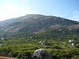
Skandagiri, also known as Kalavara Durga, is an ancient mountain fortress located approximately 70 km from Bangalore city, and 3 km from Chikballapur
in the India
n state of Karnataka
. It is off Bellary Road ( NH 7
Hyderabad-Bangalore
Highway), and overlooks Nandi Hills
, Muddenahalli
, and Kanivenarayanapura
. The peak is at an altitude of about 1350 meters. It is known as the "adventurer's paradise" and features a beautiful night trek, altitude camping, stunning sunrise, and serene and ocean like clouds.
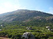
Skandagiri is one of the hill forts in the Nandi Hill ranges. The dilapidated walls of Tipu Sultan
's fort can be seen even today . This was built to be a sturdy, self sufficient fortress. It was built several centuries ago by a local king. As the story goes (told by the local people of the area), the king along with his soldiers defended the fort from Tipu Sultan for many days. After getting tired of taking the fort in this way, Tipu's generals bribed a couple of milk women who used to carry milk to the fort everyday. For several days after this, the milk women started carrying some seeds which they used to spread in the way so that Tipu's army will know the way in which to go up. On the day of the planned attack, the women added poison to the milk. Lot of the king's soldiers died after consuming the poisoned milk and the rest were killed by Tipu's invading troops.
Tippu used the fort as a military base in his fierce fight against the British. It surrendered to British troops on 19 October 1791 and was later dismantled. It remained in British hands until the peace treaty of 1792, which concluded the third Anglo-Mysore war.
There are 2 caves on the mountain. One starts from the base and as per locals, leads to the temple and fort at peak and another one is somewhere midway which is about 30 feet only. Both are yet unexplored, especially the first one. Locals say that there are pythons in the caves and have swallowed their goats who wander in the carves. Supposedly, there are 6 Samadhis in that cave and thus the area is considered holy.
Skandagiri aka Kalwarahalli Betta. Kalwara means ‘Thieves’, Halli means ‘Village’ and Betta means ‘Hill’. As the name goes, there are people around at night to fool trekkers. If one is planning to visit this beautiful place, watch out for vehicle thieves. and also while climbing be ware of snakes during night.
Directions:
At Kalawara village ask for Omkara Jyoti Ashrama/Papagni Mutt (13°25′26.6″N 77°41′28″E). There is a Shiva temple near the base of the hill, where vehicles can be parked near the gate. There are two routes up to skandagiri. One route, which can be accessed by taking the path to the left of the temple is quite steep and is recommended for more experienced climbers. The popular route is the path to the right of the temple (Between the Matt and the Ashram).
Must carry water, first aid box, snacks or light foods. Do not forget to take some warm clothing with you as it can get cold at the top. You might want to take a windsheeter or a waterproof Jerkin as the clouds passing over you can get you wet. Local villagers camp on the peak and sell omelettes, cold drinks, tea, and other refreshments. They even gather wood for you in case you want a campfire and can serve as guides over the terrain.
It is common to trek in the dark, and it's a lot fun on a beautiful full moon night. Trekkers usually start climbing at around 2:00 AM and aim to reach the top by around 5:00 AM to catch the sunrise. You must carry one torch per person if planning a night trek. Sometimes the night trek is banned because of security reasons. One must ensure that the night trek is available prior to trekking. Mid of December to second week of January is the best time to visit scandagiri and witness the beautiful scene of Sun rising over white bed of clouds under you.
This is a moderately difficult trek as the hill is precipitous and high. The trek starts from the Papagni Temple at the foot of the hill. The fortress is in full sight throughout the trek uphill. This steep and fantastic trek through a maze of dense shrub is highly intriguing. Skandagiri is a teaser. Just as you reach the fort wall content that you have topped the hill, you see another ring of fort. There are six such series of stonewalls protecting an abandoned ancient temple on the hilltop.
If you are a geologist and interested in doing some study on the trip, there are a few very old stone sculptures of Hindu deities about 100m before the base camp across a temple. Villagers have also built a modern temple right across the road.
Don't forget to carry your camera to take breathtaking pictures of 360 degree view of surroundings. You can also see Nandi Hills from here.
A local language(Kanada) guide is available at the foothill. He is staying near a small temple at foothill. He can be reached on ( +91 9141743260). You can park vehicle safely with his help.
Please take guides by finding one there or by pre-booking. If not, there is a very high chance (especially at night) of getting lost in case you are going for the 1st time or if you are not confident with the route.
Currently Night Trekking is BAN in Skandigiri ,To due to frequent cases of Snake bite .
Chikballapur
Chikkaballapur is the District Headquarters of the newly created Chikkaballapur district in the state of Karnataka, India. Located within 3 km of Muddenahalli and its nearby town, Kanivenarayanapura, the sites of the upcoming Sri Sathya Sai Baba University and College of Medicine, Indian...
in the India
India
India , officially the Republic of India , is a country in South Asia. It is the seventh-largest country by geographical area, the second-most populous country with over 1.2 billion people, and the most populous democracy in the world...
n state of Karnataka
Karnataka
Karnataka , the land of the Kannadigas, is a state in South West India. It was created on 1 November 1956, with the passing of the States Reorganisation Act and this day is annually celebrated as Karnataka Rajyotsava...
. It is off Bellary Road ( NH 7
National Highway 7 (India)
National Highway 7, commonly referred to as NH 7, is major North-South National Highway in India that runs through the states of Uttar Pradesh, Madhya Pradesh, Maharashtra, Andhra Pradesh, Karnataka, and Tamil Nadu....
Hyderabad-Bangalore
Bangalore
Bengaluru , formerly called Bengaluru is the capital of the Indian state of Karnataka. Bangalore is nicknamed the Garden City and was once called a pensioner's paradise. Located on the Deccan Plateau in the south-eastern part of Karnataka, Bangalore is India's third most populous city and...
Highway), and overlooks Nandi Hills
Nandi Hills
Nandi Hills may refer to:* Nandi Hills, Karnataka, India* Nandi Hills, Kenya...
, Muddenahalli
Muddenahalli
Muddenahalli is a centrally located town situated 7 km from Chikballapur and 1 km from Kanivenarayanapura in Chikballapur District of Karnataka State...
, and Kanivenarayanapura
Kanivenarayanapura
Kanivenarayanapura is a centrally located historical town situated 6 km from Chikballapur, 3 km from Nandi Town and 1 km from Muddenahalli in Chikballapur District of Karnataka State. It is adjacent to the birth place of the renowned Mokshagundam Visvesvarayya, one of India's most...
. The peak is at an altitude of about 1350 meters. It is known as the "adventurer's paradise" and features a beautiful night trek, altitude camping, stunning sunrise, and serene and ocean like clouds.
About
The village at the foothill of the mountain is called Kandavara Halli and the hill is called Kandavarahalli Betta (aka Skandagiri and Kalwarahalli Betta). It is in the Chikkaballapura district of Karnataka.Skandagiri is one of the hill forts in the Nandi Hill ranges. The dilapidated walls of Tipu Sultan
Tipu Sultan
Tipu Sultan , also known as the Tiger of Mysore, was the de facto ruler of the Kingdom of Mysore. He was the son of Hyder Ali, at that time an officer in the Mysorean army, and his second wife, Fatima or Fakhr-un-Nissa...
's fort can be seen even today . This was built to be a sturdy, self sufficient fortress. It was built several centuries ago by a local king. As the story goes (told by the local people of the area), the king along with his soldiers defended the fort from Tipu Sultan for many days. After getting tired of taking the fort in this way, Tipu's generals bribed a couple of milk women who used to carry milk to the fort everyday. For several days after this, the milk women started carrying some seeds which they used to spread in the way so that Tipu's army will know the way in which to go up. On the day of the planned attack, the women added poison to the milk. Lot of the king's soldiers died after consuming the poisoned milk and the rest were killed by Tipu's invading troops.
Tippu used the fort as a military base in his fierce fight against the British. It surrendered to British troops on 19 October 1791 and was later dismantled. It remained in British hands until the peace treaty of 1792, which concluded the third Anglo-Mysore war.
There are 2 caves on the mountain. One starts from the base and as per locals, leads to the temple and fort at peak and another one is somewhere midway which is about 30 feet only. Both are yet unexplored, especially the first one. Locals say that there are pythons in the caves and have swallowed their goats who wander in the carves. Supposedly, there are 6 Samadhis in that cave and thus the area is considered holy.
Skandagiri aka Kalwarahalli Betta. Kalwara means ‘Thieves’, Halli means ‘Village’ and Betta means ‘Hill’. As the name goes, there are people around at night to fool trekkers. If one is planning to visit this beautiful place, watch out for vehicle thieves. and also while climbing be ware of snakes during night.
| Altitude | About 1350 meters above sea level |
| Distance | 70 km from Bangalore |
| Nearest Town/Medical Help | Chikballapur Chikballapur Chikkaballapur is the District Headquarters of the newly created Chikkaballapur district in the state of Karnataka, India. Located within 3 km of Muddenahalli and its nearby town, Kanivenarayanapura, the sites of the upcoming Sri Sathya Sai Baba University and College of Medicine, Indian... , 5 km |
| Nearest Airport/ Railway station | Devanahalli(Bangaluru International Airport) |
| Co-ordinates | 13°25′3″N 77°40′58″E |
Getting there
There are two routes to Skandagiri:- From NH 7National Highway 7 (India)National Highway 7, commonly referred to as NH 7, is major North-South National Highway in India that runs through the states of Uttar Pradesh, Madhya Pradesh, Maharashtra, Andhra Pradesh, Karnataka, and Tamil Nadu....
, turn towards Nandi Hills. At the base of Nandi Hills turn right and proceed to Kalawara village via MuddenahalliMuddenahalliMuddenahalli is a centrally located town situated 7 km from Chikballapur and 1 km from Kanivenarayanapura in Chikballapur District of Karnataka State...
(birth place of Bharath Rathna Sir M Visvesvarayya). - From Chikballapur proceed directly to Kalawara village
Directions:
- Follow the Bangalore International Airport, better known as Bellary Road (NH 7). After crossing BIA take the diversion to Chikballapur. You can see the board for Chikballapur on NH 7 easily. Follow the same road for about 7–8 km until you find a Visvesvarayya statue to your Left. Note that this is a small bust and is easy to miss. There is also a small GaneshaGaneshaGanesha , also spelled Ganesa or Ganesh, also known as Ganapati , Vinayaka , and Pillaiyar , is one of the deities best-known and most widely worshipped in the Hindu pantheon. His image is found throughout India and Nepal. Hindu sects worship him regardless of affiliations...
temple right next to that left turn. - Take a left at this place and a right turn at the City Municipal Council a little further down. Later this shall directly lead to Papagni Mutt, which is the base of Skandagiri.
At Kalawara village ask for Omkara Jyoti Ashrama/Papagni Mutt (13°25′26.6″N 77°41′28″E). There is a Shiva temple near the base of the hill, where vehicles can be parked near the gate. There are two routes up to skandagiri. One route, which can be accessed by taking the path to the left of the temple is quite steep and is recommended for more experienced climbers. The popular route is the path to the right of the temple (Between the Matt and the Ashram).
- Nandi to Kalawara to Papagni Mutt is 6 km
- Chikballapur to Papagni Mutt is 3 km
Trekking
Level of Trekking : Moderately difficultMust carry water, first aid box, snacks or light foods. Do not forget to take some warm clothing with you as it can get cold at the top. You might want to take a windsheeter or a waterproof Jerkin as the clouds passing over you can get you wet. Local villagers camp on the peak and sell omelettes, cold drinks, tea, and other refreshments. They even gather wood for you in case you want a campfire and can serve as guides over the terrain.
It is common to trek in the dark, and it's a lot fun on a beautiful full moon night. Trekkers usually start climbing at around 2:00 AM and aim to reach the top by around 5:00 AM to catch the sunrise. You must carry one torch per person if planning a night trek. Sometimes the night trek is banned because of security reasons. One must ensure that the night trek is available prior to trekking. Mid of December to second week of January is the best time to visit scandagiri and witness the beautiful scene of Sun rising over white bed of clouds under you.
This is a moderately difficult trek as the hill is precipitous and high. The trek starts from the Papagni Temple at the foot of the hill. The fortress is in full sight throughout the trek uphill. This steep and fantastic trek through a maze of dense shrub is highly intriguing. Skandagiri is a teaser. Just as you reach the fort wall content that you have topped the hill, you see another ring of fort. There are six such series of stonewalls protecting an abandoned ancient temple on the hilltop.
If you are a geologist and interested in doing some study on the trip, there are a few very old stone sculptures of Hindu deities about 100m before the base camp across a temple. Villagers have also built a modern temple right across the road.
Don't forget to carry your camera to take breathtaking pictures of 360 degree view of surroundings. You can also see Nandi Hills from here.
A local language(Kanada) guide is available at the foothill. He is staying near a small temple at foothill. He can be reached on ( +91 9141743260). You can park vehicle safely with his help.
Important Information
Go to the right side of the Papagni Matt, then take a sharp left and go further for 500ft. Take a left turn that will take you directly to the side of the hill.Please take guides by finding one there or by pre-booking. If not, there is a very high chance (especially at night) of getting lost in case you are going for the 1st time or if you are not confident with the route.
Currently Night Trekking is BAN in Skandigiri ,To due to frequent cases of Snake bite .