
Shire of Wyalkatchem
Encyclopedia
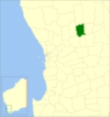
The Shire of Wyalkatchem is a Local Government Area
located in the Wheatbelt region of Western Australia
. Its seat of government is the town of Wyalkatchem
, about 190 kilometres (118 mi) northeast of Perth
, the state capital.
and Dowerin
Road Boards. On 1 July 1961, it became the Shire of Wyalkatchem under the Local Government Act 1960.
Local Government Areas of Western Australia
The Australian state of Western Australia is divided into 141 local government areas...
located in the Wheatbelt region of Western Australia
Western Australia
Western Australia is a state of Australia, occupying the entire western third of the Australian continent. It is bounded by the Indian Ocean to the north and west, the Great Australian Bight and Indian Ocean to the south, the Northern Territory to the north-east and South Australia to the south-east...
. Its seat of government is the town of Wyalkatchem
Wyalkatchem, Western Australia
Wyalkatchem townsite is located in the central agricultural region, east north east of Perth and east of Dowerin. At the 2006 census, Wyalkatchem had a population of 344....
, about 190 kilometres (118 mi) northeast of Perth
Perth, Western Australia
Perth is the capital and largest city of the Australian state of Western Australia and the fourth most populous city in Australia. The Perth metropolitan area has an estimated population of almost 1,700,000....
, the state capital.
History
On 18 June 1920, the Wyalkatchem Road District was created out of land previously administered by the NinghanShire of Trayning
The Shire of Trayning is a Local Government Area in the Wheatbelt region of Western Australia, about northwest of Merredin and about east of the state capital, Perth. The Shire covers an area of , and its seat of government is the town of Trayning.-History:...
and Dowerin
Shire of Dowerin
The Shire of Dowerin is a Local Government Area in the Wheatbelt region of Western Australia, about northeast of Perth, the state capital. The Shire covers an area of and its seat of government is the town of Dowerin.-History:...
Road Boards. On 1 July 1961, it became the Shire of Wyalkatchem under the Local Government Act 1960.
Wards
The shire has no wards, and seven councillors. The shire president is elected from amongst the councillors.Towns and localities
- WyalkatchemWyalkatchem, Western AustraliaWyalkatchem townsite is located in the central agricultural region, east north east of Perth and east of Dowerin. At the 2006 census, Wyalkatchem had a population of 344....
- BenjaberringBenjaberring, Western AustraliaBenjaberring is a small town in the Wheatbelt region of Western Australia.The name of the town originates from the Aboriginal name of a nearby water source....
- CowcowingCowcowing, Western AustraliaCowcowing is a small town located just of the Koorda-Wyalkatchem road 215km from Perthin the Wheatbelt region of Western Australia.The town originated as a railway siding and was later gazetted as a townsite in 1919. The name of the town is Aboriginal in origin and was first recorded by explorers...
- KorrelockingKorrelocking, Western AustraliaKorrelocking is a small town situated between Wyalkatchemand Trayning in the Wheatbelt region of Western Australia. At the 2006 census, Korrelocking had a population of 76....
- Nembudding
Population
| Year | Population |
|---|---|
| 1921 | 1,218 |
| 1933 | 1,533 |
| 1947 | 1,094 |
| 1954 | 1,235 |
| 1961 | 1,383 |
| 1966 | 1,252 |
| 1971 | 1,113 |
| 1976 | 1,005 |
| 1981 | 954 |
| 1986 | 786 |
| 1991 | 704 |
| 1996 | 628 |
| 2001 | 661 |
| 2006 | 564 |