

Serranía de la Macarena
Encyclopedia
Serranía de la Macarena (Macarena Mountains) is a Colombia
n mountain range located east of the Andes
in the Meta Department
. The mountains are separated by about 40 kilometers at their northern extreme from the Cordillera Oriental
(3°1′30"N 74°0′30"W). The range is orientated from north to south and is 120 kilometers in length and 30 kilometers wide. The highest peak, which is unnamed, reaches 2615 meters above sea level and is the highest point of the Llanos
. The first national reserve in Colombia was established in the central part of the mountain range in accordance with a Congressional Law promulgated in 1948. The status of National Natural Park (PNN) was designated in 1971. The ecologically protected area includes 6,200 km².
 La Macarena National Park includes the ecologically unique border areas where the flora and fauna of the Amazon
and the Orinoco
regions meet. Due to altitude, temperatures range from 42 °F to 88 °F, and this helps to maintain a high level of biodiversity
with numerous endemic species
.
Within the park one can find anteaters, jaguars, cougars, deer, 8 species of monkeys, 550 species of birds, 1,200 species of insects and 100 species of reptiles. The rare mountain tapir
does not occur in Serranía de la Macarena, but is found in the adjacent Cordillera de los Picachos National Park.
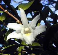
La Macarena is home to at least 48 species of orchids
, and botanists studying the area have identified more than 2,000 other species of plant life.
, labeled one of the most beautiful rivers in the world, which has been chronicled by the Colombian journalist and explorer Andrés Hurtado García.
There are also other important waterfalls such as Angostura I in the Guayabero and Caño Cafre rivers, surrounded by rocky edges with a great amount of petroglifos. Many waterfalls area difficult to spot due to the steep topography.
granite of the Guyana Shield in the Guaviare River
valley and the San Jose del Guaviare
area. The rocks of the shield are overlain by sandstone
s and conglomerates
of the Vaupes Formation of Lower Paleozoic
to the lower Oligocene
age. In the Cicuco Oil Field of the Magdalena River
Oligocene limestone
overlies the granite basement.
) dates from this period.
In recent years, portions of the Park have been used both to grow coca
, plant landmines and to house irregular rebel forces, because it is difficult for Colombian authorities to access and control the area.
By 2005 an estimated 45 km² of the Park's extension was used to grow drugs as part of the illegal drug trade
. Increased coca cultivation has contributed to damaging the Park's eco-system and diversity.
Despite the existence of drug crops, for many years the Park had never been subjected to controversial glyphosate fumigation
, as it had been forbidden by law to do so in National Parks. Later reforms relaxed the law's restrictions, allowing for the use of fumigation only after a set criteria has been met, including viability and ecological impact studies.
In late 2005, after FARC guerrillas ambushed a number of Colombian security forces near the Park, the Colombian government publicly announced the beginning of a manual coca eradication
campaign in La Macarena as a form of retaliation. Manual eradication efforts, consisting of a heavy police and military presence on the ground as a way of protecting workers, began in January 2006. These efforts lasted until the middle of the same year, manually eradicating an estimated 29.1 km² of coca from the Park.
After a number of workers and Colombian law enforcement authorities were wounded and killed due to ambushes, mines and other forms of guerrilla attacks, the government announced that fumigation would be employed to eradicate the remaining 17 km² of drug crops.
This decision has been criticized, because environmentalists fear that fumigation will contribute to the further deterioration of the Park's eco-system.
Sistema de Información Ambiental Territorial de la Amazonia colombiana SIAT-AC
Colombia
Colombia, officially the Republic of Colombia , is a unitary constitutional republic comprising thirty-two departments. The country is located in northwestern South America, bordered to the east by Venezuela and Brazil; to the south by Ecuador and Peru; to the north by the Caribbean Sea; to the...
n mountain range located east of the Andes
Andes
The Andes is the world's longest continental mountain range. It is a continual range of highlands along the western coast of South America. This range is about long, about to wide , and of an average height of about .Along its length, the Andes is split into several ranges, which are separated...
in the Meta Department
Meta Department
Meta is a department of Colombia. It is close to the geographic center of the country, to the east of the Andean mountains. A large portion of the department, which is also crossed by the Meta River, is covered by a grassland plain known as the Llanos. Its capital is Villavicencio...
. The mountains are separated by about 40 kilometers at their northern extreme from the Cordillera Oriental
Cordillera Oriental, Colombia
The Cordillera Oriental is one of three main mountain ranges that divides the Cordillera in the Andes Mountains of Colombia.It extends from southeast to northeast from the "Colombian Massif" in Huila to the Perijá Mountains in La Guajira....
(3°1′30"N 74°0′30"W). The range is orientated from north to south and is 120 kilometers in length and 30 kilometers wide. The highest peak, which is unnamed, reaches 2615 meters above sea level and is the highest point of the Llanos
Llanos
The Llanos is a vast tropical grassland plain situated to the east of the Andes in Colombia and Venezuela, in northwestern South America. It is an ecoregion of the Flooded grasslands and savannas Biome....
. The first national reserve in Colombia was established in the central part of the mountain range in accordance with a Congressional Law promulgated in 1948. The status of National Natural Park (PNN) was designated in 1971. The ecologically protected area includes 6,200 km².
Flora and fauna
Amazon Basin
The Amazon Basin is the part of South America drained by the Amazon River and its tributaries that drains an area of about , or roughly 40 percent of South America. The basin is located in the countries of Bolivia, Brazil, Colombia, Ecuador, Guyana, Peru, and Venezuela...
and the Orinoco
Orinoco
The Orinoco is one of the longest rivers in South America at . Its drainage basin, sometimes called the Orinoquia, covers , with 76.3% of it in Venezuela and the remainder in Colombia...
regions meet. Due to altitude, temperatures range from 42 °F to 88 °F, and this helps to maintain a high level of biodiversity
Biodiversity
Biodiversity is the degree of variation of life forms within a given ecosystem, biome, or an entire planet. Biodiversity is a measure of the health of ecosystems. Biodiversity is in part a function of climate. In terrestrial habitats, tropical regions are typically rich whereas polar regions...
with numerous endemic species
Endemic (ecology)
Endemism is the ecological state of being unique to a defined geographic location, such as an island, nation or other defined zone, or habitat type; organisms that are indigenous to a place are not endemic to it if they are also found elsewhere. For example, all species of lemur are endemic to the...
.
Within the park one can find anteaters, jaguars, cougars, deer, 8 species of monkeys, 550 species of birds, 1,200 species of insects and 100 species of reptiles. The rare mountain tapir
Mountain Tapir
The Mountain Tapir or Woolly Tapir is the smallest of the four species of tapir and is the only one to live outside of tropical rainforests in the wild...
does not occur in Serranía de la Macarena, but is found in the adjacent Cordillera de los Picachos National Park.
La Macarena is home to at least 48 species of orchids
Orchidaceae
The Orchidaceae, commonly referred to as the orchid family, is a morphologically diverse and widespread family of monocots in the order Asparagales. Along with the Asteraceae, it is one of the two largest families of flowering plants, with between 21,950 and 26,049 currently accepted species,...
, and botanists studying the area have identified more than 2,000 other species of plant life.
Eco-tourism
The La Macarena National and Ecological Reserve Park is internationally known the Caño CristalesCaño Cristales
Caño Cristales is a Colombian river located in the Serrania de la Macarena, province of Meta. The river is commonly called "The River of Five Colors," "The Liquid Rainbow" or even "The Most Beautiful River in the World" due to the algae produced colors like red, yellow, green and blue at the bottom...
, labeled one of the most beautiful rivers in the world, which has been chronicled by the Colombian journalist and explorer Andrés Hurtado García.
There are also other important waterfalls such as Angostura I in the Guayabero and Caño Cafre rivers, surrounded by rocky edges with a great amount of petroglifos. Many waterfalls area difficult to spot due to the steep topography.
Geology
Basement rocks on the east side of the Macarenas include the PrecambrianPrecambrian
The Precambrian is the name which describes the large span of time in Earth's history before the current Phanerozoic Eon, and is a Supereon divided into several eons of the geologic time scale...
granite of the Guyana Shield in the Guaviare River
Guaviare River
The Guaviare is a tributary of the Orinoco located in Colombia.The Guaviare has its source in two other rivers, the Ariari and the Guayabero, which in turn have their own sources in the eastern part of the Andes. At long, it is the longest river on the Orinoco and is navigable for of its total...
valley and the San Jose del Guaviare
San José del Guaviare
San José del Guaviare is a town and municipality in Colombia, capital of the department of Guaviare by the Guaviare River.-External links: *...
area. The rocks of the shield are overlain by sandstone
Sandstone
Sandstone is a sedimentary rock composed mainly of sand-sized minerals or rock grains.Most sandstone is composed of quartz and/or feldspar because these are the most common minerals in the Earth's crust. Like sand, sandstone may be any colour, but the most common colours are tan, brown, yellow,...
s and conglomerates
Conglomerate (geology)
A conglomerate is a rock consisting of individual clasts within a finer-grained matrix that have become cemented together. Conglomerates are sedimentary rocks consisting of rounded fragments and are thus differentiated from breccias, which consist of angular clasts...
of the Vaupes Formation of Lower Paleozoic
Paleozoic
The Paleozoic era is the earliest of three geologic eras of the Phanerozoic eon, spanning from roughly...
to the lower Oligocene
Oligocene
The Oligocene is a geologic epoch of the Paleogene Period and extends from about 34 million to 23 million years before the present . As with other older geologic periods, the rock beds that define the period are well identified but the exact dates of the start and end of the period are slightly...
age. In the Cicuco Oil Field of the Magdalena River
Magdalena River
The Magdalena River is the principal river of Colombia, flowing northward about through the western half of the country. It takes its name from the biblical figure Mary Magdalene. It is navigable through much of its lower reaches, in spite of the shifting sand bars at the mouth of its delta, as...
Oligocene limestone
Limestone
Limestone is a sedimentary rock composed largely of the minerals calcite and aragonite, which are different crystal forms of calcium carbonate . Many limestones are composed from skeletal fragments of marine organisms such as coral or foraminifera....
overlies the granite basement.
The problem of colonization, illegal drug crops and fumigation
The integrity of the National Park has been historically threatened by the arrival of colonists since 1970, seeking land. The town of Buenavista (MetaMeta Department
Meta is a department of Colombia. It is close to the geographic center of the country, to the east of the Andean mountains. A large portion of the department, which is also crossed by the Meta River, is covered by a grassland plain known as the Llanos. Its capital is Villavicencio...
) dates from this period.
In recent years, portions of the Park have been used both to grow coca
Coca
Coca, Erythroxylum coca, is a plant in the family Erythroxylaceae, native to western South America. The plant plays a significant role in many traditional Andean cultures...
, plant landmines and to house irregular rebel forces, because it is difficult for Colombian authorities to access and control the area.
By 2005 an estimated 45 km² of the Park's extension was used to grow drugs as part of the illegal drug trade
Illegal drug trade
The illegal drug trade is a global black market, dedicated to cultivation, manufacture, distribution and sale of those substances which are subject to drug prohibition laws. Most jurisdictions prohibit trade, except under license, of many types of drugs by drug prohibition laws.A UN report said the...
. Increased coca cultivation has contributed to damaging the Park's eco-system and diversity.
Despite the existence of drug crops, for many years the Park had never been subjected to controversial glyphosate fumigation
Fumigation
Fumigation is a method of pest control that completely fills an area with gaseous pesticides—or fumigants—to suffocate or poison the pests within. It is utilized for control of pests in buildings , soil, grain, and produce, and is also used during processing of goods to be imported or...
, as it had been forbidden by law to do so in National Parks. Later reforms relaxed the law's restrictions, allowing for the use of fumigation only after a set criteria has been met, including viability and ecological impact studies.
In late 2005, after FARC guerrillas ambushed a number of Colombian security forces near the Park, the Colombian government publicly announced the beginning of a manual coca eradication
Coca eradication
Coca eradication is a controversial strategy strongly promoted by the United States government starting in 1961 as part of its "War on Drugs" to eliminate the cultivation of coca, a plant whose leaves are not only traditionally used by indigenous cultures but also, in modern society, in the...
campaign in La Macarena as a form of retaliation. Manual eradication efforts, consisting of a heavy police and military presence on the ground as a way of protecting workers, began in January 2006. These efforts lasted until the middle of the same year, manually eradicating an estimated 29.1 km² of coca from the Park.
After a number of workers and Colombian law enforcement authorities were wounded and killed due to ambushes, mines and other forms of guerrilla attacks, the government announced that fumigation would be employed to eradicate the remaining 17 km² of drug crops.
This decision has been criticized, because environmentalists fear that fumigation will contribute to the further deterioration of the Park's eco-system.
External links
- La Macarena National Park, Spanish site of the Colombian Government
- "The colonization of La Macarena Ecological Reserve" (Virtual book in Spanish of the Colombian Luis Ángel Arango Libray).
Sistema de Información Ambiental Territorial de la Amazonia colombiana SIAT-AC