
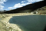
Scofield Reservoir
Encyclopedia
Scofield Reservoir is a 2815 acres (11.4 km²) reservoir
in Carbon County
, Utah
, United States
. Located on the Price River
, a tributary of the Green River
, Scofield Reservoir is adjacent to northernmost boundary of the Manti-La Sal National Forest
. The reservoir sits at an elevation of 7618 feet (2,322 m), on the northern edge of the Wasatch Plateau. Utah State Route 96
runs along the western shoreline.
After initial attempts to complete a permanent dam on the Price River, the Scofield Project was initiated by the US Bureau of Reclamation. The Scofield Project eventually irrigated area lands originally to be served by Mammoth Dam, and later by the defunct Gooseberry Project. The present day dam was completed in 1946. Besides providing flood protection due to variable stream flow, the reservoir is an important source of water for municipal and industrial sources. It is also a popular fishing and outdoor recreation spot for nearby communities.
The Mammoth Reservoir Company was incorporated and made filings on the floodwaters of the Price River
in 1896. In 1900, a group of farmers from Sanpete County
secured the rights of the company for storing water and conveying it by transmountain diversion to their lands.
During 1902, the Sanpete group had financial difficulties and the project passed into the hands of the Irrigated Lands Co. The latter company abandoned the idea of watering Sanpete County lands and made plans to irrigate 25000 acres (101.2 km²) near Price, Utah
. The company, in cooperation with the State of Utah
, proceeded with construction of Mammoth Dam. After going through considerable financial difficulty, the Irrigated Lands Co. was reorganized in 1911 to form the Price River Irrigation Co., which developed the project as rapidly as financial conditions and demand for water would permit. The dam failed June 25, 1917, when it was only partly completed, releasing 11000 acre.ft of water and causing flood damage estimated at $1 million to railroad and mining property.
The Price River Water Conservation District, a municipal corporation, was organized in 1921 for developing storage facilities in the Price River
watershed to replace the destroyed Mammoth Dam. Under the district's direction, Scofield Dam 39°47′12"N 111°07′13"W was constructed during 1925-1926. The reservoir formed behind the dam had a capacity of 6000 acre.ft. In May 1928, with the reservoir practically filled for the first time, the dam partially failed.
Emergency repairs, together with rapid evacuation of storage water through the outlet tunnel, were effective in preventing complete failure and a devastating flood. Numerous attempts at placing the dam in a safe operating condition were unsuccessful. In view of the apparent weakness of the dam, storage in Scofield Reservoir was strictly limited to a maximum of 30000 acre.ft.
The replacement of the original dam was expedited during World War II
because a potential failure of the existing dam posed a threat to the war effort. The Bureau of Reclamation investigated the development of the Scofield Project in accordance with a cooperative contract between the United States
and the State of Utah
. The study resulted in the adoption of the plan to replace the unsafe Scofield Dam with a completely new and larger structure to be erected about 800 feet (243.8 m) downstream from the existing dam.
The project was authorized by the president on June 24, 1943, under the terms of the Water Conservation and Utilization Act of August 11, 1939 (53 Stat. 1418), as amended.
Under the Utah Water Conservancy Act of 1941, the Carbon Water Conservancy District was organized in 1943 for the purpose of negotiating a contract with the United States for construction of the new dam. Contract negotiations between this district, the Price River Water Conservation District, and the United States were completed in 1943.
Construction of the new storage works by the W.W. Clyde Company
of Springville, Utah
was undertaken during World War II
to prevent possible flood damage to the main line of the Denver and Rio Grande Western Railroad
, the State highway
, the telephone and telegraph lines, and the coal mines, all of which were important to the war effort. The new dam was completed June 15, 1946.
Initially, the Federal
government viewed the dam as a flood control measure to prevent damage to vital defense industries and transportation. For the local population, Scofield Dam and Reservoir also supplied irrigation water for surrounding farms. In 1943, local farms grew alfalfa, barley, beans, corn, oats, wheat, potatoes, sugar beets, and pasture. Orchard crops around Helper
included peaches, pears, apricots, and apples.
Crop values on the Scofield Project reached over one million dollars in the 1960s and early 1970s. From 1973 to 1974, crop values jumped from $1,552,089 to $3,672,419. Drought of 1977, caused the value plunged to $1,515,005. Gross crop value reached four million dollars in 1981.
While still providing flood protection and sustainable water supply, the reservoir now serves as a popular recreation area. It is part of Scofield State Park, part of the Utah State Parks
system.
Scofield has traditionally been one of Utah's
top fisheries. Besides producing desirable sizes and quantities of trout
, it is unique in that it is an outstanding shore fishery. The reservoir is home to rainbow trout
, cutthroat trout
, redside shiner, mountain sucker
. Common invertebrate species include damselfly
, mayfly
, and crayfish
. It is also popular during the winter as an ice fishery. In recent years the fishery and its management have been impacted due to water quality impairments.
The reservoir is also home to the Scofield Triathlon, held annually since 2006.
. Approximately 45 miles (72.4 km) northwest, lies the Provo
-Orem
metropolitan area.
Reservoir
A reservoir , artificial lake or dam is used to store water.Reservoirs may be created in river valleys by the construction of a dam or may be built by excavation in the ground or by conventional construction techniques such as brickwork or cast concrete.The term reservoir may also be used to...
in Carbon County
Carbon County, Utah
Carbon County is a county located in the U.S. state of Utah. Named for the major coal deposits in the area, the county seat and largest city, is Price. Carbon County is the second largest natural gas producer in Utah , with 94 billion cubic feet produced in 2008. As of 2010 the population was...
, Utah
Utah
Utah is a state in the Western United States. It was the 45th state to join the Union, on January 4, 1896. Approximately 80% of Utah's 2,763,885 people live along the Wasatch Front, centering on Salt Lake City. This leaves vast expanses of the state nearly uninhabited, making the population the...
, United States
United States
The United States of America is a federal constitutional republic comprising fifty states and a federal district...
. Located on the Price River
Price River
The Price River is a river in the state of Utah, in the United States. The river originates in the Wasatch Plateau in central Utah and flows southeastward through Price Canyon, alongside U.S. Route 6, to the cities of Helper and Price...
, a tributary of the Green River
Green River (Utah)
The Green River, located in the western United States, is the chief tributary of the Colorado River. The watershed of the river, known as the Green River Basin, covers parts of Wyoming, Utah, and Colorado. The Green River is long, beginning in the Wind River Mountains of Wyoming and flowing...
, Scofield Reservoir is adjacent to northernmost boundary of the Manti-La Sal National Forest
Manti-La Sal National Forest
The Manti-La Sal National Forest covers 1,270,646 acres and is located in the central and southeastern parts of the U.S. state of Utah and the extreme western part of Colorado...
. The reservoir sits at an elevation of 7618 feet (2,322 m), on the northern edge of the Wasatch Plateau. Utah State Route 96
Utah State Route 96
State Route 96 is a state highway in the U.S. state of Utah, connecting SR-264 and the town of Scofield to US-6 in a span of . The route is known as the Eccles Canyon Scenic Byway, part of The Energy Loop, a National Scenic Byway....
runs along the western shoreline.
After initial attempts to complete a permanent dam on the Price River, the Scofield Project was initiated by the US Bureau of Reclamation. The Scofield Project eventually irrigated area lands originally to be served by Mammoth Dam, and later by the defunct Gooseberry Project. The present day dam was completed in 1946. Besides providing flood protection due to variable stream flow, the reservoir is an important source of water for municipal and industrial sources. It is also a popular fishing and outdoor recreation spot for nearby communities.
Hydrology
The reservoir is situated on the Price River. The reservoir is also fed by ground water and many small intermittent mountain streams during spring runoff. Principal among these are Fish Creek (Utah) and Clear Creek Canyon (Utah) Annual inflow is 52000 acre.ft.History
Irrigation development of lands served by the Scofield Project began in 1883. Ditch companies were organized, and the water was diverted from the natural flow of the Price River. From time to time, canal systems were combined and extended until it was found that natural flow of the river was inadequate to supply irrigation demands fully.The Mammoth Reservoir Company was incorporated and made filings on the floodwaters of the Price River
Price River
The Price River is a river in the state of Utah, in the United States. The river originates in the Wasatch Plateau in central Utah and flows southeastward through Price Canyon, alongside U.S. Route 6, to the cities of Helper and Price...
in 1896. In 1900, a group of farmers from Sanpete County
Sanpete County, Utah
Sanpete County is a county located in the U.S. state of Utah. The population according to the 2010 U.S. Census was 27,822. It was possibly named for a Ute Indian chief named Sanpitch, which was corrupted to Sanpete. Its county seat is Manti and its largest city is Ephraim.-Geography:According to...
secured the rights of the company for storing water and conveying it by transmountain diversion to their lands.
During 1902, the Sanpete group had financial difficulties and the project passed into the hands of the Irrigated Lands Co. The latter company abandoned the idea of watering Sanpete County lands and made plans to irrigate 25000 acres (101.2 km²) near Price, Utah
Price, Utah
Price is a city in Carbon County, Utah, United States. The city is home to the USU-College of Eastern Utah, as well as the large USU Eastern Prehistoric Museum affiliated with the college. Price is located within short distances from both Nine Mile Canyon and the Manti-La Sal National Forest...
. The company, in cooperation with the State of Utah
Utah
Utah is a state in the Western United States. It was the 45th state to join the Union, on January 4, 1896. Approximately 80% of Utah's 2,763,885 people live along the Wasatch Front, centering on Salt Lake City. This leaves vast expanses of the state nearly uninhabited, making the population the...
, proceeded with construction of Mammoth Dam. After going through considerable financial difficulty, the Irrigated Lands Co. was reorganized in 1911 to form the Price River Irrigation Co., which developed the project as rapidly as financial conditions and demand for water would permit. The dam failed June 25, 1917, when it was only partly completed, releasing 11000 acre.ft of water and causing flood damage estimated at $1 million to railroad and mining property.
The Price River Water Conservation District, a municipal corporation, was organized in 1921 for developing storage facilities in the Price River
Price River
The Price River is a river in the state of Utah, in the United States. The river originates in the Wasatch Plateau in central Utah and flows southeastward through Price Canyon, alongside U.S. Route 6, to the cities of Helper and Price...
watershed to replace the destroyed Mammoth Dam. Under the district's direction, Scofield Dam 39°47′12"N 111°07′13"W was constructed during 1925-1926. The reservoir formed behind the dam had a capacity of 6000 acre.ft. In May 1928, with the reservoir practically filled for the first time, the dam partially failed.
Emergency repairs, together with rapid evacuation of storage water through the outlet tunnel, were effective in preventing complete failure and a devastating flood. Numerous attempts at placing the dam in a safe operating condition were unsuccessful. In view of the apparent weakness of the dam, storage in Scofield Reservoir was strictly limited to a maximum of 30000 acre.ft.
The replacement of the original dam was expedited during World War II
World War II
World War II, or the Second World War , was a global conflict lasting from 1939 to 1945, involving most of the world's nations—including all of the great powers—eventually forming two opposing military alliances: the Allies and the Axis...
because a potential failure of the existing dam posed a threat to the war effort. The Bureau of Reclamation investigated the development of the Scofield Project in accordance with a cooperative contract between the United States
United States
The United States of America is a federal constitutional republic comprising fifty states and a federal district...
and the State of Utah
Utah
Utah is a state in the Western United States. It was the 45th state to join the Union, on January 4, 1896. Approximately 80% of Utah's 2,763,885 people live along the Wasatch Front, centering on Salt Lake City. This leaves vast expanses of the state nearly uninhabited, making the population the...
. The study resulted in the adoption of the plan to replace the unsafe Scofield Dam with a completely new and larger structure to be erected about 800 feet (243.8 m) downstream from the existing dam.
The project was authorized by the president on June 24, 1943, under the terms of the Water Conservation and Utilization Act of August 11, 1939 (53 Stat. 1418), as amended.
Under the Utah Water Conservancy Act of 1941, the Carbon Water Conservancy District was organized in 1943 for the purpose of negotiating a contract with the United States for construction of the new dam. Contract negotiations between this district, the Price River Water Conservation District, and the United States were completed in 1943.
Construction of the new storage works by the W.W. Clyde Company
W.W. Clyde Company
W.W. Clyde is a heavy civil construction firm based in Springville, Utah.W.W. Clyde was founded in 1926 by Wilford W. Clyde, brother to George Dewey Clyde, who later became a Governor of Utah...
of Springville, Utah
Springville, Utah
Springville is a city in Utah County, Utah, United States. It is part of the Provo–Orem, Utah Metropolitan Statistical Area. The population was 20,424 at the 2000 census, while the 2008 estimates placed it at 28,520. Just minutes south of Provo, Springville is a bedroom community for...
was undertaken during World War II
World War II
World War II, or the Second World War , was a global conflict lasting from 1939 to 1945, involving most of the world's nations—including all of the great powers—eventually forming two opposing military alliances: the Allies and the Axis...
to prevent possible flood damage to the main line of the Denver and Rio Grande Western Railroad
Denver and Rio Grande Western Railroad
The Denver & Rio Grande Western Railroad , often shortened to Rio Grande or D&RGW, formerly the Denver & Rio Grande Railroad, is a defunct U.S. railroad company. The railroad started as a narrow gauge line running south from Denver, Colorado in 1870; however, served mainly as a transcontinental...
, the State highway
Utah State Route 96
State Route 96 is a state highway in the U.S. state of Utah, connecting SR-264 and the town of Scofield to US-6 in a span of . The route is known as the Eccles Canyon Scenic Byway, part of The Energy Loop, a National Scenic Byway....
, the telephone and telegraph lines, and the coal mines, all of which were important to the war effort. The new dam was completed June 15, 1946.
Current dam
Scofield Dam is a zoned earthfill structure with a structural height of 125 feet (38.1 m). The dam's crest length is 575 feet (175.3 m) with a top width of thirty feet. It contains 204,000 cubic yards of material. The maximum base width is 400 feet (121.9 m). Total capacity of Scofield Reservoir is 73600 acre.ft with an active capacity of 65800 acre.ft. The spillway is an uncontrolled concrete crest and concrete lined chute at the right abutment.Uses
Uses of Scofield Reservoir and its watershed include coal mining, agriculture, residential, fishing, hunting, snowmobiling, camping, and a variety of other types of summer and winter recreations.Initially, the Federal
Federal government of the United States
The federal government of the United States is the national government of the constitutional republic of fifty states that is the United States of America. The federal government comprises three distinct branches of government: a legislative, an executive and a judiciary. These branches and...
government viewed the dam as a flood control measure to prevent damage to vital defense industries and transportation. For the local population, Scofield Dam and Reservoir also supplied irrigation water for surrounding farms. In 1943, local farms grew alfalfa, barley, beans, corn, oats, wheat, potatoes, sugar beets, and pasture. Orchard crops around Helper
Helper, Utah
Helper is a city in Carbon County, Utah, United States about 120 miles southeast of Salt Lake City and northwest of the city of Price. It is also known as the "Hub of Carbon County". The population was 2,025 at the 2000 census....
included peaches, pears, apricots, and apples.
Crop values on the Scofield Project reached over one million dollars in the 1960s and early 1970s. From 1973 to 1974, crop values jumped from $1,552,089 to $3,672,419. Drought of 1977, caused the value plunged to $1,515,005. Gross crop value reached four million dollars in 1981.
While still providing flood protection and sustainable water supply, the reservoir now serves as a popular recreation area. It is part of Scofield State Park, part of the Utah State Parks
Utah State Parks
Utah State Parks is the common name for the Division of Utah State Parks and Recreation; a division of the Utah Department of Natural Resources. This is the state agency that manages the state park system of the U.S...
system.
Scofield has traditionally been one of Utah's
Utah
Utah is a state in the Western United States. It was the 45th state to join the Union, on January 4, 1896. Approximately 80% of Utah's 2,763,885 people live along the Wasatch Front, centering on Salt Lake City. This leaves vast expanses of the state nearly uninhabited, making the population the...
top fisheries. Besides producing desirable sizes and quantities of trout
Trout
Trout is the name for a number of species of freshwater and saltwater fish belonging to the Salmoninae subfamily of the family Salmonidae. Salmon belong to the same family as trout. Most salmon species spend almost all their lives in salt water...
, it is unique in that it is an outstanding shore fishery. The reservoir is home to rainbow trout
Rainbow trout
The rainbow trout is a species of salmonid native to tributaries of the Pacific Ocean in Asia and North America. The steelhead is a sea run rainbow trout usually returning to freshwater to spawn after 2 to 3 years at sea. In other words, rainbow trout and steelhead trout are the same species....
, cutthroat trout
Cutthroat trout
The cutthroat trout is a species of freshwater fish in the salmon family of order Salmoniformes. It is one of the many fish species colloquially known as trout...
, redside shiner, mountain sucker
Mountain sucker
The Mountain Sucker is a sucker found throughout western North America.This is a slender and streamlined sucker, generally olive green to brown above and on the sides, and white to yellowish underneath. There may be a pattern of darker blotches along the sides...
. Common invertebrate species include damselfly
Damselfly
Damselflies are insects in the order Odonata. Damselflies are similar to dragonflies, but the adults can be distinguished by the fact that the wings of most damselflies are held along, and parallel to, the body when at rest...
, mayfly
Mayfly
Mayflies are insects which belong to the Order Ephemeroptera . They have been placed into an ancient group of insects termed the Palaeoptera, which also contains dragonflies and damselflies...
, and crayfish
Crayfish
Crayfish, crawfish, or crawdads – members of the superfamilies Astacoidea and Parastacoidea – are freshwater crustaceans resembling small lobsters, to which they are related...
. It is also popular during the winter as an ice fishery. In recent years the fishery and its management have been impacted due to water quality impairments.
The reservoir is also home to the Scofield Triathlon, held annually since 2006.
Communities
To the direct south of the reservoir is the town of Scofield, UtahScofield, Utah
Scofield is a town in Carbon County, Utah, United States. The population was 28 at the 2000 census. Scofield's name is frequently applied to the 1900 mine disaster in the Pleasant Valley Coal Company's Winter Quarters mine. The community was named for General Charles W...
. Approximately 45 miles (72.4 km) northwest, lies the Provo
Provo, Utah
Provo is the third largest city in the U.S. state of Utah, located about south of Salt Lake City along the Wasatch Front. Provo is the county seat of Utah County and lies between the cities of Orem to the north and Springville to the south...
-Orem
Orem, Utah
Orem is a city in Utah County, Utah, United States, in the north-central part of the state. It is adjacent to Provo, Lindon, and Vineyard and is about south of Salt Lake City. Orem is one of the principal cities of the Provo-Orem, Utah Metropolitan Statistical Area, which includes all of Utah and...
metropolitan area.