

Utah State Parks
Encyclopedia
Utah State Parks is the common name for the Division of Utah State Parks and Recreation; a division of the Utah Department of Natural Resources. This is the state agency that manages the state park
system of the U.S. state
of Utah
.
Utah's state park system began with four heritage parks in 1957: Sugar House Park
(which was later removed from the system), Utah Territorial Statehouse
in Fillmore, This Is the Place Monument
in Salt Lake City, and Camp Floyd
outside of Lehi.
Today, there are 43 Utah State Parks and several undeveloped areas totaling over 95000 acres (384.5 km²) of land and more than one million surface acres of water. Utah's state parks are scattered throughout Utah; from Bear Lake State Park
at the Utah/Idaho
border to Edge of the Cedars State Park Museum deep in the Four Corners region, and everywhere in between.
The Division of Utah State Parks and Recreation also administers the Utah off highway vehicle, boating, and trails programs. In this capacity, they work to provide access to waterways and trails, and promote education, safety, and resource protection.
The division's mission statement is "To enhance the quality of life by preserving and providing natural, cultural, and recreational resources for the enjoyment, education, and inspiration of this and future generations."

State park
State parks are parks or other protected areas managed at the federated state level within those nations which use "state" as a political subdivision. State parks are typically established by a state to preserve a location on account of its natural beauty, historic interest, or recreational...
system of the U.S. state
U.S. state
A U.S. state is any one of the 50 federated states of the United States of America that share sovereignty with the federal government. Because of this shared sovereignty, an American is a citizen both of the federal entity and of his or her state of domicile. Four states use the official title of...
of Utah
Utah
Utah is a state in the Western United States. It was the 45th state to join the Union, on January 4, 1896. Approximately 80% of Utah's 2,763,885 people live along the Wasatch Front, centering on Salt Lake City. This leaves vast expanses of the state nearly uninhabited, making the population the...
.
Utah's state park system began with four heritage parks in 1957: Sugar House Park
Sugar House Park
Sugar House Park, or Sugarhouse Park, is located between I-80, 2100 South, 1300 East, and 1700 East in Salt Lake City, Utah. The park is at the heart of the Sugar House neighborhood and is the site of a fireworks show and concert every Independence Day of the United States and a popular sledding...
(which was later removed from the system), Utah Territorial Statehouse
Utah Territorial Statehouse
The Utah Territorial Statehouse in Fillmore, Utah, USA, was built between 1852 and 1855. After becoming a territory in 1850, Utah's leaders choose Fillmore as the territory's capital city, and the statehouse was constructed to be the area's first capitol building...
in Fillmore, This Is the Place Monument
This Is The Place Monument
"This Is The Place" redirects here. For the song by Red Hot Chili Peppers, see By the WayThe This Is The Place Monument is a historical monument at the This Is The Place Heritage Park, located on the east side of Salt Lake City, Utah, at the mouth of Emigration Canyon...
in Salt Lake City, and Camp Floyd
Camp Floyd
Camp Floyd was a short-lived U.S. Army post near Fairfield, Utah, United States. The site is now a Utah state park known as Camp Floyd / Stagecoach Inn State Park and Museum.-Camp Floyd:...
outside of Lehi.
Today, there are 43 Utah State Parks and several undeveloped areas totaling over 95000 acres (384.5 km²) of land and more than one million surface acres of water. Utah's state parks are scattered throughout Utah; from Bear Lake State Park
Bear Lake State Park (Utah)
Bear Lake State Park is a state park of Utah, USA, along the shore of Bear Lake on the Idaho border. It offers three recreation areas: Rendezvous Beach, Bear Lake Marina, and East Beach. The park also hosts many annual events, such as a Mountain Man Rendezvous and Bear Lake Raspberry...
at the Utah/Idaho
Idaho
Idaho is a state in the Rocky Mountain area of the United States. The state's largest city and capital is Boise. Residents are called "Idahoans". Idaho was admitted to the Union on July 3, 1890, as the 43rd state....
border to Edge of the Cedars State Park Museum deep in the Four Corners region, and everywhere in between.
The Division of Utah State Parks and Recreation also administers the Utah off highway vehicle, boating, and trails programs. In this capacity, they work to provide access to waterways and trails, and promote education, safety, and resource protection.
The division's mission statement is "To enhance the quality of life by preserving and providing natural, cultural, and recreational resources for the enjoyment, education, and inspiration of this and future generations."
| Park Name | Web- site |
County or Counties | Area in Acres (ha) | Elevation | Date Opened |
Remarks |
|---|---|---|---|---|---|---|
| Anasazi State Park Museum | http://stateparks.utah.gov/parks/anasazi | Garfield Garfield County, Utah Garfield County is a county located in the U.S. state of Utah. As of 2000 the population was 4,735. It was named for James A. Garfield, President of the United States in 1881. Its county seat and largest city is Panguitch.-Geography:... |
6 acres (2.4 ha) | 6,700 ft (2042 m) | 1970 | Interprets a large Ancestral Puebloan Ancient Pueblo Peoples Ancient Pueblo People or Ancestral Pueblo peoples were an ancient Native American culture centered on the present-day Four Corners area of the United States, comprising southern Utah, northern Arizona, northwest New Mexico, and southern Colorado... village occupied from AD 1160 to 1235. |
| Antelope Island State Park Antelope Island State Park Antelope Island State Park is a Utah state park on Antelope Island in the Great Salt Lake. The park is in Davis County, Utah in the United States. It is open for year-round recreation and features an abundant wildlife population, including one of the largest free roaming herds of American Bison in... |
http://stateparks.utah.gov/parks/antelope-island | Davis Davis County, Utah Davis County is a county located in the U.S. state of Utah. As of 2010 the population was 306,479, a 28.2% increase over the 2000 figure of 238,994. It was named for Daniel C. Davis, captain in the Mormon Battalion. The county is part of the Ogden–Clearfield Metropolitan Statistical Area as... |
22,022 acres (11340 ha) | 5,308 ft (1618 m) | 1969 | Protects Antelope Island Antelope Island Antelope Island, with an area of , is the largest island of 10 islands located within the Great Salt Lake, Utah, United States. The island lies in the southeastern portion of the lake, near Salt Lake City and Davis County, and becomes a peninsula when the lake is at extremely low levels. Antelope... , the largest island in the Great Salt Lake Great Salt Lake The Great Salt Lake, located in the northern part of the U.S. state of Utah, is the largest salt water lake in the western hemisphere, the fourth-largest terminal lake in the world. In an average year the lake covers an area of around , but the lake's size fluctuates substantially due to its... and habitat for bison American Bison The American bison , also commonly known as the American buffalo, is a North American species of bison that once roamed the grasslands of North America in massive herds... , pronghorn antelope Pronghorn The pronghorn is a species of artiodactyl mammal endemic to interior western and central North America. Though not an antelope, it is often known colloquially in North America as the prong buck, pronghorn antelope, or simply antelope, as it closely resembles the true antelopes of the Old World and... , and bighorn sheep Bighorn Sheep The bighorn sheep is a species of sheep in North America named for its large horns. These horns can weigh up to , while the sheep themselves weigh up to . Recent genetic testing indicates that there are three distinct subspecies of Ovis canadensis, one of which is endangered: Ovis canadensis sierrae... . |
| Bear Lake State Park Bear Lake State Park (Utah) Bear Lake State Park is a state park of Utah, USA, along the shore of Bear Lake on the Idaho border. It offers three recreation areas: Rendezvous Beach, Bear Lake Marina, and East Beach. The park also hosts many annual events, such as a Mountain Man Rendezvous and Bear Lake Raspberry... |
http://stateparks.utah.gov/parks/bear-lake | Rich Rich County, Utah Rich County is a county located in the U.S. state of Utah. The southern half of Bear Lake and the Bear Lake Valley lie on the northern edge of the county. The Bear River Valley lies in most of the eastern portion of the county. The elevation of these valleys is close to , and the rest of the county... |
5,900 ft (1798 m) | 1962 | Comprises three units on Bear Lake. | |
| Camp Floyd / Stagecoach Inn State Park and Museum Camp Floyd Camp Floyd was a short-lived U.S. Army post near Fairfield, Utah, United States. The site is now a Utah state park known as Camp Floyd / Stagecoach Inn State Park and Museum.-Camp Floyd:... |
http://stateparks.utah.gov/stateparks/parks/camp-floyd/ | Utah Utah County, Utah Utah County is a county located in the U.S. state of Utah. As of 2000, the population was 368,536 and by 2008 was estimated at 530,837. It was named for the Spanish name for the Ute Indians. The county seat and largest city is Provo... |
40 acres (16 ha) | 4,877 ft (1487 m) | 1958 | Interprets sites from the time of a massive 1858-1861 U.S. Army camp prompted by fear of the Utah War Utah War The Utah War, also known as the Utah Expedition, Buchanan's Blunder, the Mormon War, or the Mormon Rebellion was an armed confrontation between LDS settlers in the Utah Territory and the armed forces of the United States government. The confrontation lasted from May 1857 until July 1858... . |
| Coral Pink Sand Dunes State Park Coral Pink Sand Dunes State Park Coral Pink Sand Dunes State Park is a state park of Utah, USA, located between Mount Carmel Junction and Kanab, south and west of U.S. Highway 89 in southwestern Utah... |
http://stateparks.utah.gov/parks/coral-pink | Kane Kane County, Utah As of the census of 2000, there were 6,046 people, 2,237 households, and 1,628 families residing in the county. The population density was 2 people per square mile . There were 3,767 housing units at an average density of 1 per square mile... |
3,730 acres (1510 ha) | 6,000 ft (1829 m) | 1963 | Preserves the only dune Dune In physical geography, a dune is a hill of sand built by wind. Dunes occur in different forms and sizes, formed by interaction with the wind. Most kinds of dunes are longer on the windward side where the sand is pushed up the dune and have a shorter "slip face" in the lee of the wind... field on the Colorado Plateau Colorado Plateau The Colorado Plateau, also called the Colorado Plateau Province, is a physiographic region of the Intermontane Plateaus, roughly centered on the Four Corners region of the southwestern United States. The province covers an area of 337,000 km2 within western Colorado, northwestern New Mexico,... , with a unique color caused by iron oxide Iron oxide Iron oxides are chemical compounds composed of iron and oxygen. All together, there are sixteen known iron oxides and oxyhydroxides.Iron oxides and oxide-hydroxides are widespread in nature, play an important role in many geological and biological processes, and are widely utilized by humans, e.g.,... s and minerals in the Navajo sandstone Navajo Sandstone Navajo Sandstone is a geologic formation in the Glen Canyon Group that is spread across the U.S. states of northern Arizona, northwest Colorado, and Utah; as part of the Colorado Plateau province of the United States... . |
| Dead Horse Point State Park Dead Horse Point State Park Dead Horse Point State Park is a state park of Utah, USA, featuring a dramatic overlook of the Colorado River and Canyonlands National Park. The park is so named because of its use as a natural corral by cowboys in the 19th century... |
http://stateparks.utah.gov/stateparks/parks/dead-horse/ | Grand Grand County, Utah Grand County is a county located in the U.S. state of Utah. As of 2000 the population was 8,485, and by 2005 had been estimated at 8,743. It was named for the Colorado River, which at the time of statehood was known as the Grand River. Its county seat and largest city is Moab.-Geography:According... and San Juan San Juan County, Utah As of the current census of 2010, there were 14,746 people and 4,505 households. The racial and ethnic composition of the population was 50.4% Native American, 45.8% white, 0.3% Asian, 0.2% African American and 2.3% reporting two or more races... |
5,300 acres (2145 ha) | 5,900 ft (1798 m) | 1959 | Showcases views of the Colorado River Colorado River The Colorado River , is a river in the Southwestern United States and northwestern Mexico, approximately long, draining a part of the arid regions on the western slope of the Rocky Mountains. The watershed of the Colorado River covers in parts of seven U.S. states and two Mexican states... and Canyonlands National Park Canyonlands National Park Canyonlands National Park is a U.S. National Park located in southeastern Utah near the town of Moab and preserves a colorful landscape eroded into countless canyons, mesas and buttes by the Colorado River, the Green River, and their respective tributaries. The park is divided into four districts:... from a finger of land once used as a horse corral. |
| Deer Creek State Park Deer Creek State Park Deer Creek State Park a state park of Utah, USA, featuring large Deer Creek Dam and Reservoir. The park is located near Midway, Utah, in the southeast corner of Heber Valley.- The park :... |
http://stateparks.utah.gov/parks/deer-creek/ | Wasatch Wasatch County, Utah Wasatch County is a county located in the U.S. state of Utah. It was named for a Ute Indian word meaning mountain pass or low place in the high mountains. Its county seat and largest city is Heber City.The county is governed by a county council with an appointed county manager.Wasatch County is... |
3,260 acres (1319 ha) | 5,400 ft (1646 m) | 1971 | Adjoins the extremely popular 2965 acres (1,199.9 ha) Deer Creek Reservoir Deer Creek Dam and Reservoir The Deer Creek Dam and Reservoir hydroelectric facilities are located on the Provo River in western Wasatch County, about northeast of Provo, Utah. The dam is a zoned earthfill structure high with a crest length of . The dam contains 2,810,000 cubic yards of material and forms a reservoir of ... . |
| East Canyon State Park East Canyon State Park East Canyon State Park is a state park of Utah, USA, featuring a reservoir. The park is located northeast of Salt Lake City in Morgan County, Utah.- Park facilities :Located in a narrow-walled canyon, East Canyon State Park is at an elevation of... |
http://www.stateparks.utah.gov/parks/east-canyon | Morgan Morgan County, Utah Morgan County is a county located in the U.S. state of Utah. As of 2010 the population was 9,469. It was named for Jedediah Morgan Grant, father of Heber J. Grant, who served as president of the Church of Jesus Christ of Latter-day Saints... |
267 acres (108 ha) | 5,700 ft (1737 m) | 1962 | Features a reservoir in a canyon first traversed by the Donner Party Donner Party The Donner Party was a group of American pioneers who set out for California in a wagon train. Delayed by a series of mishaps, they spent the winter of 1846–47 snowbound in the Sierra Nevada... and soon thereafter by Mormon pioneers. |
| Edge of the Cedars State Park Museum | http://stateparks.utah.gov/parks/edge-of-the-cedars | San Juan San Juan County, Utah As of the current census of 2010, there were 14,746 people and 4,505 households. The racial and ethnic composition of the population was 50.4% Native American, 45.8% white, 0.3% Asian, 0.2% African American and 2.3% reporting two or more races... |
16 acres (6.5 ha) | 6,200 ft (1890 m) | 1978 | Interprets an Ancestral Puebloan Ancient Pueblo Peoples Ancient Pueblo People or Ancestral Pueblo peoples were an ancient Native American culture centered on the present-day Four Corners area of the United States, comprising southern Utah, northern Arizona, northwest New Mexico, and southern Colorado... village occupied from AD 825 to 1125. |
| Escalante Petrified Forest State Park Escalante Petrified Forest State Park Escalante Petrified Forest State Park is a state park of Utah, USA, located just outside the town of Escalante. In 1954 Wide Hollow Reservoir was constructed to provide irrigation for the town of Escalante. The reservoir is stocked with rainbow trout and bluegill, and is popular for water sports... |
http://stateparks.utah.gov/parks/escalante | Garfield Garfield County, Utah Garfield County is a county located in the U.S. state of Utah. As of 2000 the population was 4,735. It was named for James A. Garfield, President of the United States in 1881. Its county seat and largest city is Panguitch.-Geography:... |
1,350 acres (546 ha) | 5,900 ft (1798 m) | 1976 | Features petrified wood Petrified wood Petrified wood is the name given to a special type of fossilized remains of terrestrial vegetation. It is the result of a tree having turned completely into stone by the process of permineralization... and other fossil Fossil Fossils are the preserved remains or traces of animals , plants, and other organisms from the remote past... s plus a recreational reservoir. |
| Flight Park State Recreation Area Flight Park State Recreation Area Flight Park State Recreation Area is a state park of Utah, USA, dedicated to hang gliding and paragliding. The park is located on the south side of Point of the Mountain, just north of Lehi... |
http://stateparks.utah.gov/parks/flight-park | Salt Lake Salt Lake County, Utah Salt Lake County is a county located in the U.S. state of Utah. It had a population of 1,029,655 at the 2010 census. Its county seat and largest city is Salt Lake City, the state capital. It occupies Salt Lake Valley, as well as parts of the surrounding mountains, the Oquirrh Mountains to the west... and Utah Utah County, Utah Utah County is a county located in the U.S. state of Utah. As of 2000, the population was 368,536 and by 2008 was estimated at 530,837. It was named for the Spanish name for the Ute Indians. The county seat and largest city is Provo... |
147 acres (60 ha) | 5,146 ft (1569 m) | 2006 | Offers one of the world's best training sites for hang gliding Hang gliding Hang gliding is an air sport in which a pilot flies a light and unmotorized foot-launchable aircraft called a hang glider .... and parasailing Parasailing Parasailing, also known as parascending, or "parakiting" is a recreational kiting activity where a person is towed behind a vehicle while attached to a specially designed canopy wing that reminds one of a parachute, known as a parasail wing... , plus a modelport for radio control Radio control Radio control is the use of radio signals to remotely control a device. The term is used frequently to refer to the control of model vehicles from a hand-held radio transmitter... aircraft. |
| Fremont Indian State Park and Museum | http://stateparks.utah.gov/stateparks/parks/fremont/ | Sevier Sevier County, Utah As of the census of 2000, there were 18,842 people, 6,081 households, and 4,907 families residing in the county. The population density was 10 people per square mile . There were 7,016 housing units at an average density of 4 per square mile... |
889 acres (360 ha) | 5,900 ft (1798 m) | 1987 | Preserves rock art Rock art Rock art is a term used in archaeology for any human-made markings made on natural stone. They can be divided into:*Petroglyphs - carvings into stone surfaces*Pictographs - rock and cave paintings... and artifacts from the largest Fremont culture Fremont culture The Fremont culture or Fremont people is a pre-Columbian archaeological culture which received its name from the Fremont River in the U.S. state of Utah where the first Fremont sites were discovered. The Fremont River itself is named for John Charles Frémont, an American explorer. It inhabited... village yet discovered. |
| Frontier Homestead State Park Museum Frontier Homestead State Park Museum Frontier Homestead State Park Museum is state park and museum of Utah, USA, located in Cedar City. The museum was opened to the public in 1980, originally named "Iron Mission State Park" for the pioneering attempts of Mormon settlers to create an iron industry... |
http://stateparks.utah.gov/parks/frontier-homestead | Iron Iron County, Utah As of the census of 2000, there were 33,779 people, 10,627 households, and 8,076 families residing in the county. The population density was 10 people per square mile . There were 13,618 housing units at an average density of 4 per square mile... |
11 acres (4 ha) | 5,800 ft (1768 m) | 1973 | Preserves historic structures and equipment from the 1850s to the 1920s, including Old Iron Town Old Iron Town, Utah Old Iron Town, originally Iron City, is a ghost town in Iron County, in the U.S. state of Utah. It is located in Dixie National Forest, about from Cedar City. The settlement was founded in 1868 as a second attempt to mine iron from Iron Mountain after a disappointing yield from Cedar City... and an extensive collection of horse-drawn vehicles. Formerly called Iron Mission State Park. |
| Goblin Valley State Park Goblin Valley State Park Goblin Valley State Park is a state park of Utah, USA.Its eminent feature is its thousands of hoodoos and hoodoo rocks, which are formations of mushroom-shaped rock pinnacles, some as high as several meters... |
http://stateparks.utah.gov/stateparks/parks/goblin-valley/ | Emery Emery County, Utah Emery County is a county located in the U.S. state of Utah. As of 2000 the population was 10,860, and by 2009 had been estimated to decrease to 10,629. It was named for George W. Emery, governor of the Utah Territory in 1875... |
3,654 acres (1479 ha) | 5,000 ft (1524 m) | 1974 | Showcases an unearthly landscape of hoodoo Hoodoo (geology) A hoodoo is a tall, thin spire of rock that protrudes from the bottom of an arid drainage basin or badland. Hoodoos consist of relatively soft rock topped by harder, less easily eroded stone that protects each column from the elements... s and other rock formations. |
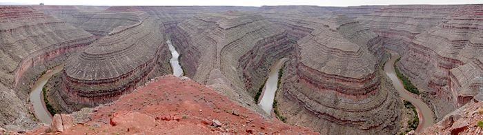
| Goosenecks State Park Goosenecks State Park Goosenecks State Park is a state park of Utah, USA, overlooking a deep meander of the San Juan River. The park is located near the southern border of the state a short distance from Mexican Hat, Utah. Millions of years ago, the Monument Upwarp forced the river to carve incised meanders over deep... |
http://stateparks.utah.gov/parks/goosenecks | San Juan San Juan County, Utah As of the current census of 2010, there were 14,746 people and 4,505 households. The racial and ethnic composition of the population was 50.4% Native American, 45.8% white, 0.3% Asian, 0.2% African American and 2.3% reporting two or more races... |
10 acres (4 ha) | 4,500 ft (1372 m) | 1962 | Overlooks some dramatic meander Meander A meander in general is a bend in a sinuous watercourse. A meander is formed when the moving water in a stream erodes the outer banks and widens its valley. A stream of any volume may assume a meandering course, alternately eroding sediments from the outside of a bend and depositing them on the... s of the San Juan River. |
| Great Salt Lake Great Salt Lake The Great Salt Lake, located in the northern part of the U.S. state of Utah, is the largest salt water lake in the western hemisphere, the fourth-largest terminal lake in the world. In an average year the lake covers an area of around , but the lake's size fluctuates substantially due to its... State Marina |
http://stateparks.utah.gov/parks/salt-lake | Salt Lake Salt Lake County, Utah Salt Lake County is a county located in the U.S. state of Utah. It had a population of 1,029,655 at the 2010 census. Its county seat and largest city is Salt Lake City, the state capital. It occupies Salt Lake Valley, as well as parts of the surrounding mountains, the Oquirrh Mountains to the west... |
162 acres (66 ha) | 4,200 ft (1280 m) | 1978 | Maintains a public boat launch and 320-slip marina Marina A marina is a dock or basin with moorings and supplies for yachts and small boats.A marina differs from a port in that a marina does not handle large passenger ships or cargo from freighters.... on the Great Salt Lake Great Salt Lake The Great Salt Lake, located in the northern part of the U.S. state of Utah, is the largest salt water lake in the western hemisphere, the fourth-largest terminal lake in the world. In an average year the lake covers an area of around , but the lake's size fluctuates substantially due to its... . |
| Green River State Park Green River State Park Green River State Park is a state park of Utah, USA, located in the town of Green River. The park consists of a nine-hole golf course, a campground shaded with cottonwood trees, and a boat ramp. The Green River hosts catfish, carp, and four unique native fish that are threatened with extinction... |
http://stateparks.utah.gov/parks/green-river | Emery Emery County, Utah Emery County is a county located in the U.S. state of Utah. As of 2000 the population was 10,860, and by 2009 had been estimated to decrease to 10,629. It was named for George W. Emery, governor of the Utah Territory in 1875... and Grand Grand County, Utah Grand County is a county located in the U.S. state of Utah. As of 2000 the population was 8,485, and by 2005 had been estimated at 8,743. It was named for the Colorado River, which at the time of statehood was known as the Grand River. Its county seat and largest city is Moab.-Geography:According... |
53 acres (21 ha) | 4,050 ft (1234 m) | 1965 | Features a shady campground, nine-hole golf course, and float trip launching on the Green River Green River (Utah) The Green River, located in the western United States, is the chief tributary of the Colorado River. The watershed of the river, known as the Green River Basin, covers parts of Wyoming, Utah, and Colorado. The Green River is long, beginning in the Wind River Mountains of Wyoming and flowing... . |
| Gunlock State Park Gunlock State Park Gunlock State Park is a state park of Utah, USA, adjoining a reservoir. The park is located approximately northwest of St George. The reservoir dam was constructed in 1970 for irrigation water and flood control.... |
http://stateparks.utah.gov/parks/gunlock | Washington Washington County, Utah As of the census of 2000, there were 90,354 people, 29,939 households, and 23,442 families residing in the county. The population density was 37 people per square mile . There were 36,478 housing units at an average density of 15 per square mile... |
549 acres (222 ha) | 3,600 ft (1097 m) | 1970 | Adjoins a 266 acres (107.6 ha) reservoir. |
| Historic Union Pacific Rail Trail State Park Historic Union Pacific Rail Trail State Park The Historic Union Pacific Rail Trail State Park is a recreational trail that follows abandoned railroad lines in Summit County, Utah, United States.The Historic Union Pacific Rail Trail is long, and averages wide... |
http://stateparks.utah.gov/parks/historic-union | Summit Summit County, Utah Summit County is a county located in the U.S. state of Utah, occupying a rugged and mountainous area. In 2010 its population was 36,324. It is part of the Salt Lake City Metropolitan Statistical Area as well as the Salt Lake City–Ogden–Clearfield Combined Statistical Area. The county is... |
450 acres (182 ha) | 6,900 ft (2103 m) | 1992 | Comprises a 28 miles (45.1 km) rail trail Rail trail A rail trail is the conversion of a disused railway easement into a multi-use path, typically for walking, cycling and sometimes horse riding. The characteristics of former tracks—flat, long, frequently running through historical areas—are appealing for various development. The term sometimes also... on a route used by the Union Pacific Railroad Union Pacific Railroad The Union Pacific Railroad , headquartered in Omaha, Nebraska, is the largest railroad network in the United States. James R. Young is president, CEO and Chairman.... from 1880 to 1989. |
| Huntington State Park Huntington State Park Huntington State Park is a state park of Utah, USA, featuring a warm-water reservoir. The park is located near the town of Huntington.Huntington Reservoir was completed in 1966 as part of an Emery County irrigation and recreation project. This warm-water reservoir supports waterskiing, fishing,... |
http://stateparks.utah.gov/parks/huntington | Emery Emery County, Utah Emery County is a county located in the U.S. state of Utah. As of 2000 the population was 10,860, and by 2009 had been estimated to decrease to 10,629. It was named for George W. Emery, governor of the Utah Territory in 1875... |
111 acres (45 ha) | 5,840 ft (1780 m) | 1966 | Features a warm-water reservoir. |
| Hyrum State Park Hyrum State Park Hyrum State Park is a state park and reservoir in Cache County, Utah, USA.Hyrum State Park is in the northeastern part of Utah. It lies at , and consists of surrounding a reservoir... |
http://stateparks.utah.gov/parks/hyrum | Cache | 264 acres (107 ha) | 4,700 ft (1433 m) | 1959 | Surrounds a 450 acres (182.1 ha) reservoir. |
| Jordan River Off-Highway Vehicle State Recreation Area Jordan River Off-Highway Vehicle State Recreation Area Jordan River Off-Highway Vehicle State Recreation Area is a Utah State Park located in Salt Lake City, Utah, USA. The park is dedicated to recreation with off highway vehicles. It consists of four separate tracks, with tabletops and banked turns, and is open from approximately early April to... |
http://stateparks.utah.gov/parks/jordan-river | Salt Lake Salt Lake County, Utah Salt Lake County is a county located in the U.S. state of Utah. It had a population of 1,029,655 at the 2010 census. Its county seat and largest city is Salt Lake City, the state capital. It occupies Salt Lake Valley, as well as parts of the surrounding mountains, the Oquirrh Mountains to the west... |
350 acres (142 ha) | 4,700 ft (1433 m) | 2002 | Offers four tracks for off highway vehicles along the Jordan River Jordan River (Utah) The Jordan River in the U.S. state of Utah is a river about long. Regulated by pumps at its headwaters at Utah Lake, it flows northward through the Salt Lake Valley and empties into the Great Salt Lake. Four of Utah's five largest cities—Salt Lake City, West Valley City, West Jordan and... . |
| Jordanelle State Park Jordanelle Reservoir Jordanelle Reservoir is a reservoir in Wasatch County, Utah, United States, just north of Heber City.Jordanelle Reservoir is fed and drained primarily by the Provo River, and is impounded by the Jordanelle Dam, an Earthen dam. The construction of the dam resulted in the reroutings of U.S. Route 40... |
http://stateparks.utah.gov/parks/jordanelle | Wasatch Wasatch County, Utah Wasatch County is a county located in the U.S. state of Utah. It was named for a Ute Indian word meaning mountain pass or low place in the high mountains. Its county seat and largest city is Heber City.The county is governed by a county council with an appointed county manager.Wasatch County is... |
6,166 ft (1879 m) | 1995 | Comprises two recreation areas on Jordanelle Reservoir Jordanelle Reservoir Jordanelle Reservoir is a reservoir in Wasatch County, Utah, United States, just north of Heber City.Jordanelle Reservoir is fed and drained primarily by the Provo River, and is impounded by the Jordanelle Dam, an Earthen dam. The construction of the dam resulted in the reroutings of U.S. Route 40... . |
|
| Kodachrome Basin State Park Kodachrome Basin State Park Kodachrome Basin is a state park of Utah, USA. It is situated above sea level, south of Utah Route 12, and southeast of Bryce Canyon National Park. It is accessible from the north from Cannonville by a paved road and from the south by Road 400, a dirt road from the Page, Arizona area to... |
http://stateparks.utah.gov/stateparks/parks/kodachrome/ | Kane Kane County, Utah As of the census of 2000, there were 6,046 people, 2,237 households, and 1,628 families residing in the county. The population density was 2 people per square mile . There were 3,767 housing units at an average density of 1 per square mile... |
2,240 acres (906 ha) | 5,800 ft (1768 m) | 1963 | Showcases 67 rock spires and other geologic wonders in a basin so photogenic it was named after Kodachrome Kodachrome Kodachrome is the trademarked brand name of a type of color reversal film that was manufactured by Eastman Kodak from 1935 to 2009.-Background:... film. |
| Millsite State Park Millsite State Park Millsite State Park is a state park of Utah, USA, located at the mouth of Ferron Canyon near the town of Ferron.Millsite State Park offers access to off highway vehicle and mountain bike riding areas. The reservoir is open to swimming, boating, waterskiing, and fishing... |
http://stateparks.utah.gov/parks/millsite | Emery Emery County, Utah Emery County is a county located in the U.S. state of Utah. As of 2000 the population was 10,860, and by 2009 had been estimated to decrease to 10,629. It was named for George W. Emery, governor of the Utah Territory in 1875... |
638 acres (258 ha) | 6,100 ft (1859 m) | Features a reservoir and lands for off highway vehicles and mountain biking Mountain biking Mountain biking is a sport which consists of riding bicycles off-road, often over rough terrain, using specially adapted mountain bikes. Mountain bikes share similarities with other bikes, but incorporate features designed to enhance durability and performance in rough terrain.Mountain biking can... . |
|
| Otter Creek State Park Otter Creek Reservoir Otter Creek Reservoir is a high alpine reservoir located in Piute County Utah, United States.It is a popular location for rainbow trout fishing.... |
http://stateparks.utah.gov/parks/otter-creek | Piute Piute County, Utah Piute County is a county located in the U.S. state of Utah. The population in 2000 was 1,435, and by 2005 had been estimated to decrease to 1,365. It was named for the Paiute tribe of Native Americans. The county seat is Junction and the largest city is Circleville.-Geography:According to the U.S... |
80 acres (32 ha) | 5,900 ft (1798 m) | Features a 3120 acres (1,262.6 ha) reservoir, begun in 1897 as one of the earliest dam projects in Utah. | |
| Palisade State Park Palisade State Park Palisade State Park is a state park of Utah, USA, located just outside the small town of Sterling. The park offers tent, RV, and cabin camping, along with fishing, swimming, non-motorized boating, golfing, and hiking. Off highway vehicle trails are also accessible from the park.-History:In the... |
http://stateparks.utah.gov/parks/palisade | Sanpete Sanpete County, Utah Sanpete County is a county located in the U.S. state of Utah. The population according to the 2010 U.S. Census was 27,822. It was possibly named for a Ute Indian chief named Sanpitch, which was corrupted to Sanpete. Its county seat is Manti and its largest city is Ephraim.-Geography:According to... |
64 acres (26 ha) | 5,800 ft (1768 m) | 1962 | Features a reservoir and 18-hole golf course on the former site of a private resort founded in the 1860s. |
| Piute State Park Piute State Park Piute State Park is a state park of Utah, USA, located just north of Junction. This park is a primitive area; there are no facilities. Piute offers camping, swimming, boating, and fishing for rainbow trout, cutthroat trout and brown trout.- History :... |
http://stateparks.utah.gov/parks/piute | Piute Piute County, Utah Piute County is a county located in the U.S. state of Utah. The population in 2000 was 1,435, and by 2005 had been estimated to decrease to 1,365. It was named for the Paiute tribe of Native Americans. The county seat is Junction and the largest city is Circleville.-Geography:According to the U.S... |
40 acres (16 ha) | 5,900 ft (1798 m) | 1963 | Protects a quiet fishing reservoir on the Sevier River Sevier River The Sevier River , extending , is the longest Utah river entirely in the state and drains an extended chain of mountain farming valleys to the intermittent Sevier Lake... . |
| Quail Creek State Park Quail Creek State Park Quail Creek State Park is a state park of Utah, USA, featuring a reservoir. The park is located west of Hurricane and south of Harrisburg. Quail Creek State Park offers camping, boating, swimming, and fishing.... |
http://stateparks.utah.gov/parks/quail-creek | Washington Washington County, Utah As of the census of 2000, there were 90,354 people, 29,939 households, and 23,442 families residing in the county. The population density was 37 people per square mile . There were 36,478 housing units at an average density of 15 per square mile... |
3,300 ft (1006 m) | 1986 | Adjoins a 600 acres (242.8 ha) reservoir surrounded by red rock desert. | |
| Red Fleet State Park Red Fleet State Park Red Fleet State Park is a state park of Utah, USA, featuring a reservoir and a fossil trackway of dinosaur footprints. The park is located north of Vernal.-Geography:... |
http://stateparks.utah.gov/parks/red-fleet | Uintah Uintah County, Utah This page deals with the Utah County. For the Wyoming County, see Uinta County, Wyoming.Uintah County is a county located in the U.S. state of Utah. As of 2000 the population was 25,224 and by 2009 was estimated at 31,536. It was named for the Ute Indians, the tribe that lives in the basin. Its... |
1,963 acres (794 ha) | 5,500 ft (1676 m) | 1988 | Features a 750 acres (303.5 ha) reservoir and a fossil trackway Fossil trackway A fossil trackway is a type of trace fossil, a trackway made by an organism. Many fossil trackways were made by dinosaurs, early tetrapods, and other quadrupeds and bipeds on land... of dinosaur Dinosaur Dinosaurs are a diverse group of animals of the clade and superorder Dinosauria. They were the dominant terrestrial vertebrates for over 160 million years, from the late Triassic period until the end of the Cretaceous , when the Cretaceous–Paleogene extinction event led to the extinction of... footprints. |
| Rockport State Park Rockport Reservoir Rockport Reservoir, also called Wanship Reservoir, is a reservoir in Summit County, Utah, United States.-Reservoir:Rockport Reservoir is located just south of the town of Wanship on Utah State Route 32... |
http://stateparks.utah.gov/parks/rockport | Summit Summit County, Utah Summit County is a county located in the U.S. state of Utah, occupying a rugged and mountainous area. In 2010 its population was 36,324. It is part of the Salt Lake City Metropolitan Statistical Area as well as the Salt Lake City–Ogden–Clearfield Combined Statistical Area. The county is... |
550 acres (223 ha) | 6,000 ft (1829 m) | 1966 | Features a 1080 acres (437.1 ha) reservoir. |
| Sand Hollow State Park Sand Hollow State Park Sand Hollow State Park is a state park of Utah, USA, featuring a reservoir and an extensive off highway vehicle recreation area on Sand Mountain. The park is near the town of Hurricane.... |
http://stateparks.utah.gov/parks/sand-hollow | Washington Washington County, Utah As of the census of 2000, there were 90,354 people, 29,939 households, and 23,442 families residing in the county. The population density was 37 people per square mile . There were 36,478 housing units at an average density of 15 per square mile... |
20,611 acres (8341 ha) | 3,000 ft (914 m) | 2003 | Features a 1322 acres (535 ha) reservoir and an extensive off highway vehicle recreation area. |
| Scofield State Park Scofield Reservoir Scofield Reservoir is a reservoir in Carbon County, Utah, United States. Located on the Price River, a tributary of the Green River, Scofield Reservoir is adjacent to northernmost boundary of the Manti-La Sal National Forest. The reservoir sits at an elevation of , on the northern edge of the... |
http://stateparks.utah.gov/stateparks/parks/scofield/ | Carbon Carbon County, Utah Carbon County is a county located in the U.S. state of Utah. Named for the major coal deposits in the area, the county seat and largest city, is Price. Carbon County is the second largest natural gas producer in Utah , with 94 billion cubic feet produced in 2008. As of 2010 the population was... |
7,600 ft (2316 m) | 1965 | Features a 2800 acres (1,133.1 ha) reservoir. | |
| Snow Canyon State Park Snow Canyon State Park Snow Canyon State Park is a state park of Utah, USA, featuring a canyon carved from the red and white Navajo sandstone in the Red Mountains. The park is located near Ivins, Utah in Washington County... |
http://stateparks.utah.gov/stateparks/parks/snow-canyon/ | Washington Washington County, Utah As of the census of 2000, there were 90,354 people, 29,939 households, and 23,442 families residing in the county. The population density was 37 people per square mile . There were 36,478 housing units at an average density of 15 per square mile... |
7,400 acres (2995 ha) | 3,100 ft (945 m) | 1962 | Showcases a canyon carved out of colorful Navajo sandstone Navajo Sandstone Navajo Sandstone is a geologic formation in the Glen Canyon Group that is spread across the U.S. states of northern Arizona, northwest Colorado, and Utah; as part of the Colorado Plateau province of the United States... and landforms created by the Santa Clara Volcano Santa Clara Volcano Santa Clara Volcano is a volcanic field and lava flow in southwest Utah. The most prominent features are two cinder cones that rise above Snow Canyon. The southern cinder cone and most of the north cinder cone are within the boundaries of Snow Canyon State Park. The city of St. George, Utah is... . |
| Starvation State Park Starvation State Park Starvation State Park and Reservoir is a state park in northeastern Utah, USA, featuring a reservoir. The park is northwest of the town of Duchesne, Utah.-Facilities:... |
http://stateparks.utah.gov/parks/starvation | Duchesne Duchesne County, Utah Duchesne County is a county located in the U.S. state of Utah. As of 2010 the population was 18,607, a 29.5% increase over the 2000 figure of 14,371. Its county seat is Duchesne and the largest city is Roosevelt.-Geography:... |
3,500 acres (1416 ha) | 5,700 ft (1737 m) | 1972 | Features a 3495 acres (1,414.4 ha) reservoir where early settlers once struggled against starvation. |
| Steinaker State Park Steinaker State Park Steinaker State Park is a state park and reservoir of Utah, USA, located north of Vernal in Uintah County, Utah.Steinaker State Park opened to the public in 1964. It lies at an elevation of in northeastern Utah, south of the Uinta Mountains. The climate is arid with hot summers and cold winters.... |
http://stateparks.utah.gov/parks/steinaker | Uintah Uintah County, Utah This page deals with the Utah County. For the Wyoming County, see Uinta County, Wyoming.Uintah County is a county located in the U.S. state of Utah. As of 2000 the population was 25,224 and by 2009 was estimated at 31,536. It was named for the Ute Indians, the tribe that lives in the basin. Its... |
2,283 acres (924 ha) | 5,500 ft (1676 m) | 1964 | Features an 820 acres (331.8 ha) reservoir. |
| This Is the Place Heritage Park This Is The Place Heritage Park The This Is the Place Heritage Park is located on the east side of Salt Lake City, Utah, USA at the foot of the Wasatch Range and near the mouth of Emigration Canyon.-History:... |
http://stateparks.utah.gov/parks/this-is-the-place | Salt Lake Salt Lake County, Utah Salt Lake County is a county located in the U.S. state of Utah. It had a population of 1,029,655 at the 2010 census. Its county seat and largest city is Salt Lake City, the state capital. It occupies Salt Lake Valley, as well as parts of the surrounding mountains, the Oquirrh Mountains to the west... |
450 acres (182 ha) | 4,921 ft (1500 m) | Interprets Utah's settlement era with a living history Living history Living history is an activity that incorporates historical tools, activities and dress into an interactive presentation that seeks to give observers and participants a sense of stepping back in time. Although it does not necessarily seek to reenact a specific event in history, living history is... village and This Is the Place Monument This Is The Place Monument "This Is The Place" redirects here. For the song by Red Hot Chili Peppers, see By the WayThe This Is The Place Monument is a historical monument at the This Is The Place Heritage Park, located on the east side of Salt Lake City, Utah, at the mouth of Emigration Canyon... . |
|
| Territorial Statehouse State Park Museum Utah Territorial Statehouse The Utah Territorial Statehouse in Fillmore, Utah, USA, was built between 1852 and 1855. After becoming a territory in 1850, Utah's leaders choose Fillmore as the territory's capital city, and the statehouse was constructed to be the area's first capitol building... |
http://stateparks.utah.gov/parks/territorial-statehouse | Millard Millard County, Utah Millard County is a county located in the U.S. state of Utah. In 2010, its population was 12,420. It was named for Millard Fillmore, thirteenth President of the United States. Its county seat is Fillmore and the largest city is Delta.-Geography:... |
3 acres (1.2 ha) | 5,100 ft (1554 m) | 1957 | Interprets the capitol of Utah Territory Utah Territory The Territory of Utah was an organized incorporated territory of the United States that existed from September 9, 1850, until January 4, 1896, when the final extent of the territory was admitted to the Union as the State of Utah.... , the state's oldest government building, constructed between 1852 and 1855. |
| Utah Field House of Natural History State Park Museum | http://stateparks.utah.gov/parks/field-house | Uintah Uintah County, Utah This page deals with the Utah County. For the Wyoming County, see Uinta County, Wyoming.Uintah County is a county located in the U.S. state of Utah. As of 2000 the population was 25,224 and by 2009 was estimated at 31,536. It was named for the Ute Indians, the tribe that lives in the basin. Its... |
2 acres (0.8 ha) | 5,300 ft (1615 m) | 1959 | Houses a state-owned museum of natural history Natural history Natural history is the scientific research of plants or animals, leaning more towards observational rather than experimental methods of study, and encompasses more research published in magazines than in academic journals. Grouped among the natural sciences, natural history is the systematic study... . |
| Utah Lake State Park Utah Lake State Park Utah Lake State Park is a state park of Utah, USA. It contains part of Utah Lake, the largest fresh water lake in the state.- Camping :Lakeshore CampgroundCamping April 1-October 31Reservations Accepted - April 15-October 15Stay Limit - 14 Days... |
http://stateparks.utah.gov/parks/utah-lake/ | Utah Utah County, Utah Utah County is a county located in the U.S. state of Utah. As of 2000, the population was 368,536 and by 2008 was estimated at 530,837. It was named for the Spanish name for the Ute Indians. The county seat and largest city is Provo... |
308 acres (125 ha) | 4,500 ft (1372 m) | 1970 | Adjoins Utah Lake Utah Lake Utah Lake is a freshwater lake in the U.S. state of Utah. On the western side of Utah Valley, the lake is overlooked by Mount Timpanogos and Mount Nebo. The lake's only river outlet, the Jordan River, is a tributary of the Great Salt Lake and is highly regulated with pumps. Evaporation accounts... , the state's largest body of fresh water. |
| Wasatch Mountain State Park Wasatch Mountain State Park Wasatch Mountain State Park is a state park of Utah, USA, located in the Heber Valley of Wasatch County near Midway.Established in 1961, Wasatch Mountain State Park is Utah's most developed state park. Named for Wasatch Mountain, the park consists of , and sits at an elevation of... |
http://stateparks.utah.gov/parks/wasatch | Wasatch Wasatch County, Utah Wasatch County is a county located in the U.S. state of Utah. It was named for a Ute Indian word meaning mountain pass or low place in the high mountains. Its county seat and largest city is Heber City.The county is governed by a county council with an appointed county manager.Wasatch County is... |
21,592 acres (8738 ha) | 5,900 ft (1798 m) | 1968 | Features extensive recreational developments, including facilities built for the 2002 Winter Olympics 2002 Winter Olympics The 2002 Winter Olympics, officially the XIX Olympic Winter Games, were a winter multi-sport event that was celebrated in February 2002 in and around Salt Lake City, Utah, United States. Approximately 2,400 athletes from 77 nations participated in 78 events in fifteen disciplines, held throughout... . |
| Willard Bay State Park Willard Bay Willard Bay is a reservoir in Northern Utah.- Geography :Willard Bay is a freshwater reservoir located in eastern Box Elder County, Utah, north-west of the city of Ogden, on the north-eastern floodplains of the Great Salt Lake. The reservoir is operated by the Weber Basin Water Conservancy... |
http://www.utah.com/stateparks/willard_bay.htm | Box Elder Box Elder County, Utah Box Elder County is a county located in the U.S. state of Utah. It lies on the north end of the Great Salt Lake, covering a large area north to the Idaho border and west to the Nevada border. Included in this area are large tracts of barren desert, contrasted by high, forested mountains. The... |
4,200 ft (1280 m) | 1966 | Provides water recreation opportunities on a 9900 acres (4,006.4 ha) freshwater reservoir on the floodplain Floodplain A floodplain, or flood plain, is a flat or nearly flat land adjacent a stream or river that stretches from the banks of its channel to the base of the enclosing valley walls and experiences flooding during periods of high discharge... of the Great Salt Lake Great Salt Lake The Great Salt Lake, located in the northern part of the U.S. state of Utah, is the largest salt water lake in the western hemisphere, the fourth-largest terminal lake in the world. In an average year the lake covers an area of around , but the lake's size fluctuates substantially due to its... . |
|
| Yuba State Park Yuba State Park Yuba State Park is a state park of Utah, USA, featuring the Yuba Reservoir on the Sevier River. The park is located approximately south of Nephi. Recreational opportunities include camping, boating, swimming, fishing, and nearby off highway vehicle riding.-History:Yuba State Park got its name... |
http://stateparks.utah.gov/parks/yuba | Juab Juab County, Utah Juab County is a county located in the U.S. state of Utah. As of 2000 the population was 8,238, and by 2005 had been estimated at 9,113. It was named from an Indian word meaning thirsty valley, or possibly only valley. Its county seat and largest city is Nephi.Juab County is part of the... and Sanpete Sanpete County, Utah Sanpete County is a county located in the U.S. state of Utah. The population according to the 2010 U.S. Census was 27,822. It was possibly named for a Ute Indian chief named Sanpitch, which was corrupted to Sanpete. Its county seat is Manti and its largest city is Ephraim.-Geography:According to... |
15,940 acres (6451 ha) | 5,100 ft (1554 m) | 1970 | Features a reservoir on the Sevier River Sevier River The Sevier River , extending , is the longest Utah river entirely in the state and drains an extended chain of mountain farming valleys to the intermittent Sevier Lake... . |